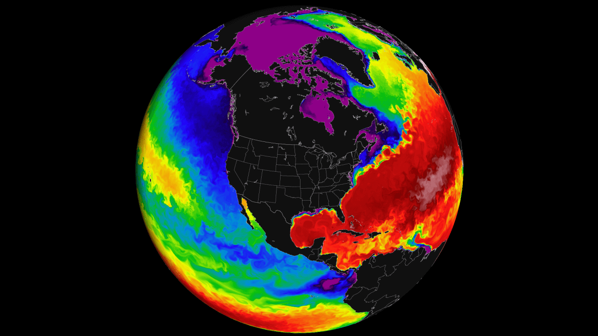
The tropical Pacific Ocean is undergoing a strong transformation as we enter 2026, with La Niña dissolving faster than initially expected. A powerful Westerly Wind Burst has swept across the tropics, erasing a lot of the cold anomalies and signaling the end of an era for the current atmospheric cycle.
As we head into the Spring season, the weather influence of La Niña is forecast to fade across North America and Europe. A rapid transition is now underway, with models pointing toward a new El Niño event emerging already in Summer and reaching peak intensity during the 2026/2027 Winter season.
We are currently also monitoring a stratospheric Polar Vortex disruption above the North Pole, which could redefine weather patterns deep into Spring, while the La Niña fades. In this article, we will break down the latest oceanic shifts and long-range forecasts to see how this transition from La Niña to El Niño will reshape weather across the Northern Hemisphere in the coming months.
ENSO Cycle: Running the Global Weather System
ENSO is short for “El Niño Southern Oscillation”. This is a region of the equatorial Pacific Ocean that changes between warm and cold phases in about every 1-3 years.
These ocean temperature anomalies don’t just bring the main “impact” for global weather, but can also act as the “indicator light”, indicating the changes in the global weather system as they form and also dissipate.
The image below shows the ENSO regions across the tropical Pacific. The main area covers the central part, shown in the image as the Niño 3.4 region. In this region, we determine the ENSO phases by looking at the seasonal sea-surface temperature anomalies (warmer/colder).
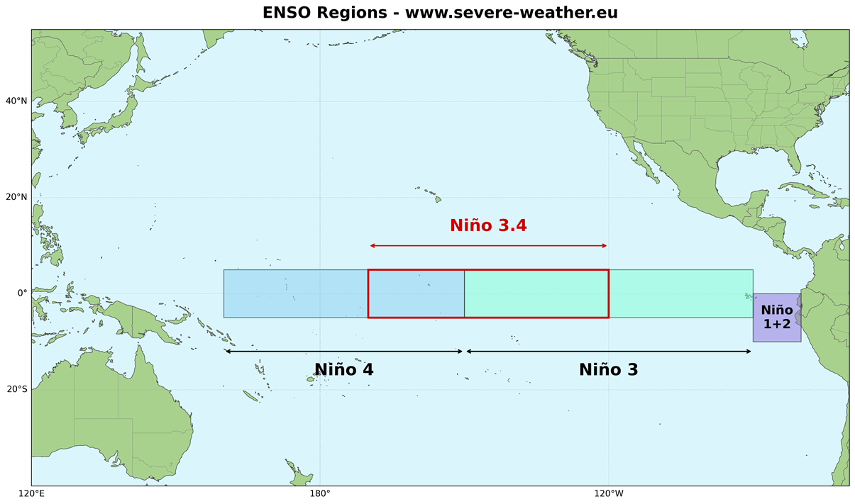
The cold ENSO phase is called La Niña, and the warm phase is called El Niño. Each ENSO phase has a major influence on the complex ocean-atmosphere feedback system. These changes gradually affect global circulation, altering weather patterns worldwide.
A specific phase usually starts to develop between late summer and early fall and typically lasts until next summer. But some events can last even up to two years.
In the image below, you can see a direct comparison between ocean temperature anomalies for each of the ENSO phases. Both examples show realistic data from the 10 strongest events for each phase.
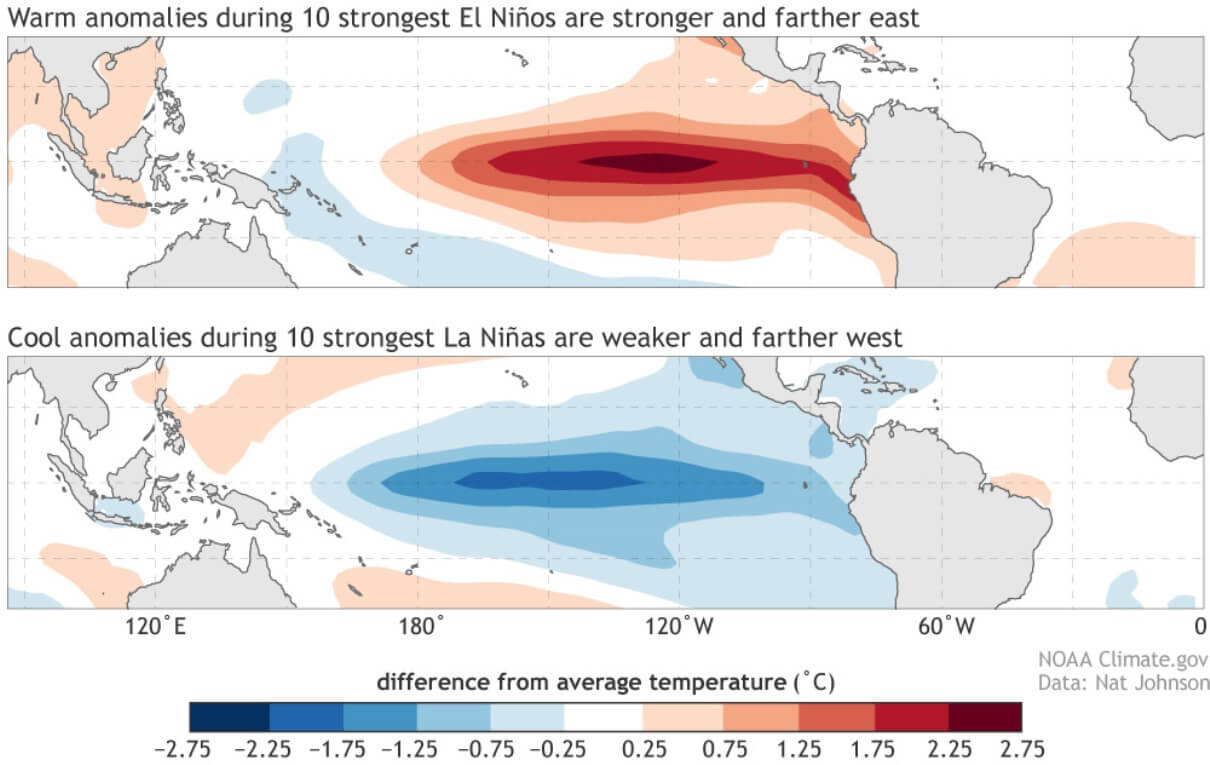
Each phase has a very different pressure and rainfall impact on the tropics, and (over time) on the global weather circulation.
But how exactly does the ENSO shift between these phases? The answer is that the tropical trade winds usually start or stop a certain phase by mixing the ocean surface layers and altering the ocean currents, and thus the ocean temperature.
The trade winds are steady and persistent, blowing towards (and along) the Equator in both Hemispheres.
Below is our updated map, which shows the prevailing near-surface winds, based on actual ECMWF data from the past 4 decades. You can nicely see the easterly trade winds in the Atlantic Ocean and in the Pacific Ocean, which help to drive the ENSO region warming and cooling.
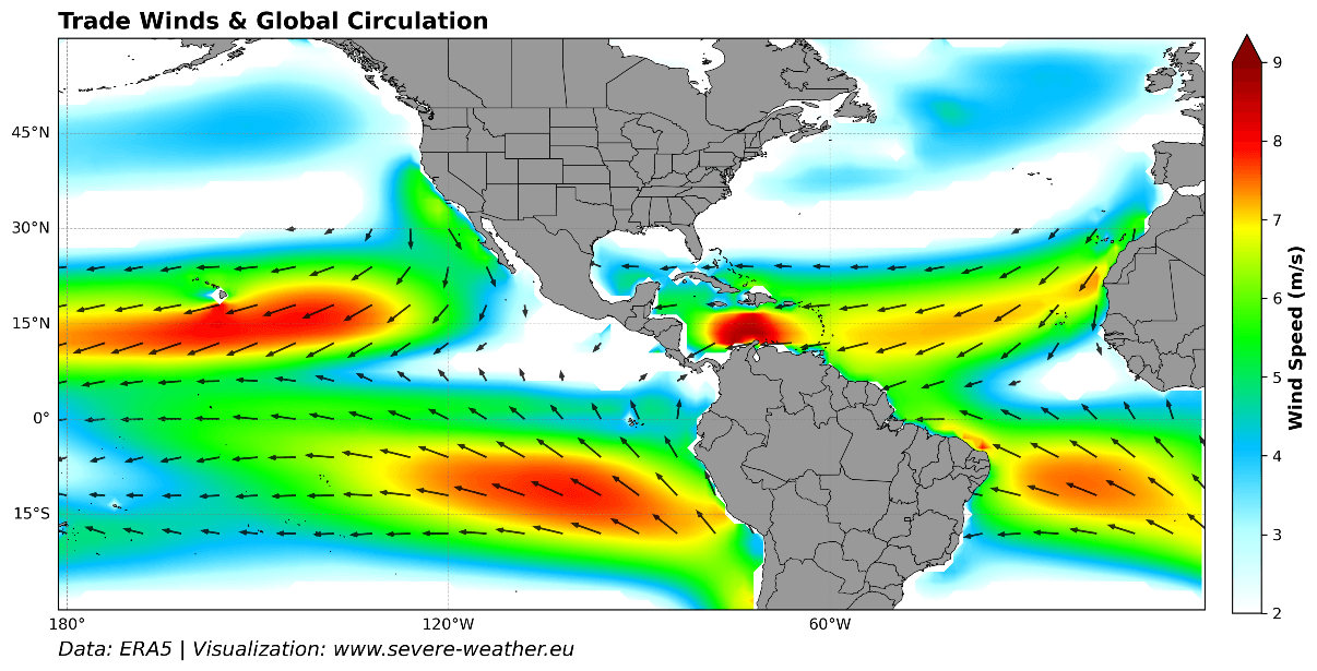
When these easterly winds get stronger, they change the ocean surface currents and start pushing the water from east to west. This moves warm surface water towards the west, bringing up deeper (colder) water closer to the surface to replace it, starting a La Niña. This event is called upwelling.
But when these trade winds get weak or reversed, the westerly flow promotes warmer ocean temperatures on the surface, reversing the ocean cooling and starting an El Niño event.
We have recently seen a very strong trade wind anomaly, called a Westerly Wind Burst. These westerly winds moved across the ENSO regions, removing a lot of the cold ocean anomaly of the La Niña.
La Niña Rapid Breakdown Goes Into Overdrive
Below is a special graphic that shows the changing ocean surface temperature in recent months across the tropics. You can see the cold La Niña event reach peak strength and area in late Fall. But since then, the cold anomalies have begun to dissipate slowly, with a much stronger collapse in recent weeks.
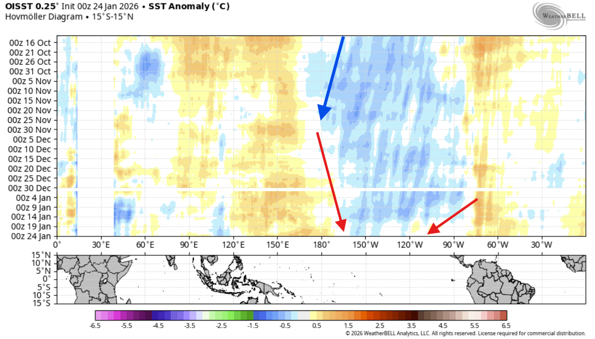
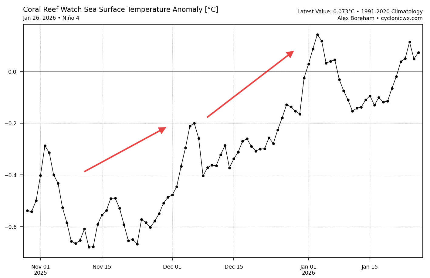
This is confirmed by the ENSO region 4 (west) analysis below, which shows the anomaly data for the past 3 months. You can see a rapid temperature anomaly rise since mid-November, now already reaching into positive values, removing the cold anomalies from the western ENSO region.
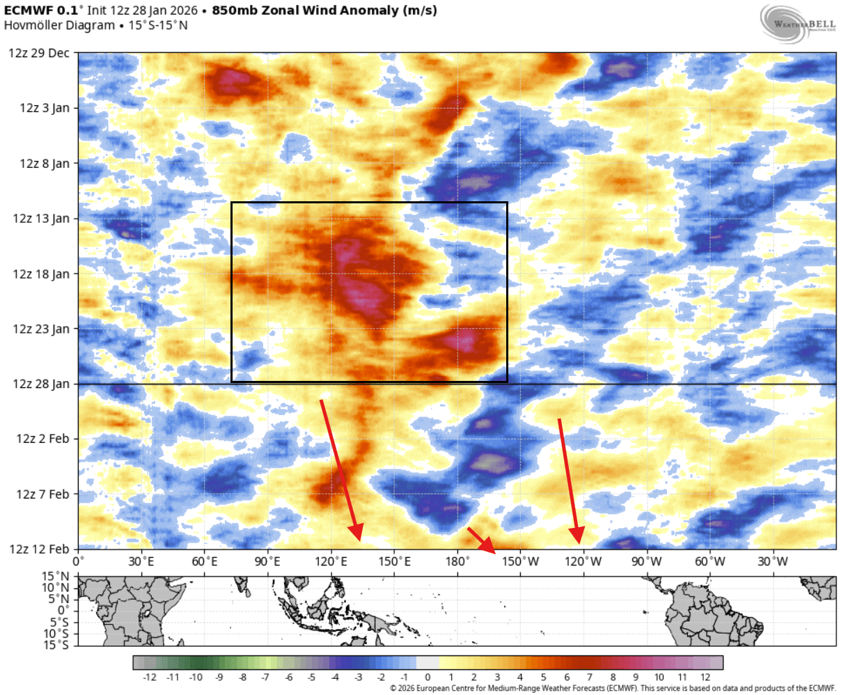
Below you can see the latest trade wind analysis and forecast, which shows the unusually strong westerly wind burst across the Pacific in recent days. Westerly wind anomalies can rapidly erode weak cold anomalies. In the forecast part, you can also see the continued trend for more westerly trade wind anomalies.
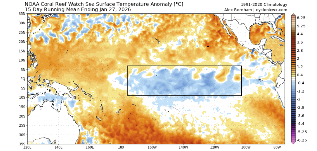
The latest ocean analysis below shows the main ENSO region that we watch. You can still see the cold La Niña anomaly, but it’s getting weaker on both sides to the east and west. The actual negative values are also not as strong anymore across this region, and are also starting to mix with warmer anomalies.
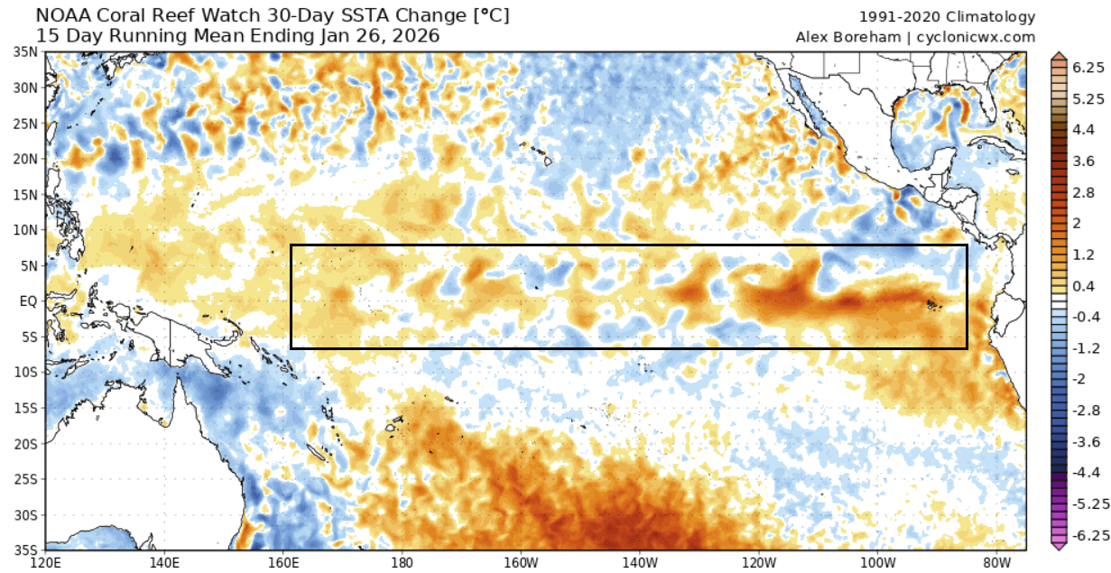
The whole process is nicely reflected below in the latest 30-day ocean temperature change map, where you can see the warming trend across all the ENSO regions. We have recently seen a stronger burst of warming in the eastern parts, nicely seen in the analysis below, and driven by weaker trade winds in that part.
This is much better seen in the video below, which shows the last 90 days of ocean temperature changes in the ENSO region. You can see a healthy La Niña event and how rapidly it started to dissolve in recent weeks.
All this is connected to strong temperature changes deep beneath the ocean surface. The image below shows the latest subsurface ocean temperature anomalies across the tropical Pacific. A large warm pool has developed in the west, at around 100-250m (300-800ft) depth, making its way further east, eroding the cold subsurface temperatures.
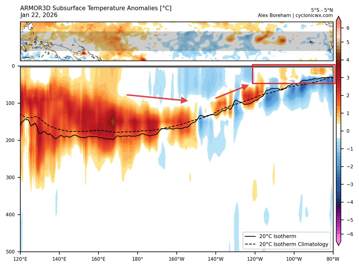
The expansion also results in the cutoff of colder water from the depth. This makes the ocean surface more prone to continued warming as the warm pool expands below the surface to the east.
But the atmospheric impact of La Niña still takes time to disappear from the atmosphere, as it’s not an instant response to the ocean anomalies. That’s why we can still expect to see the La Niña weather influence at least into the early part of Spring.
The 2026 Outlook: A Major Oceanic Shift
Looking ahead, we can see a clear indication of the end of La Niña and a rapid transition into a new El Niño event.
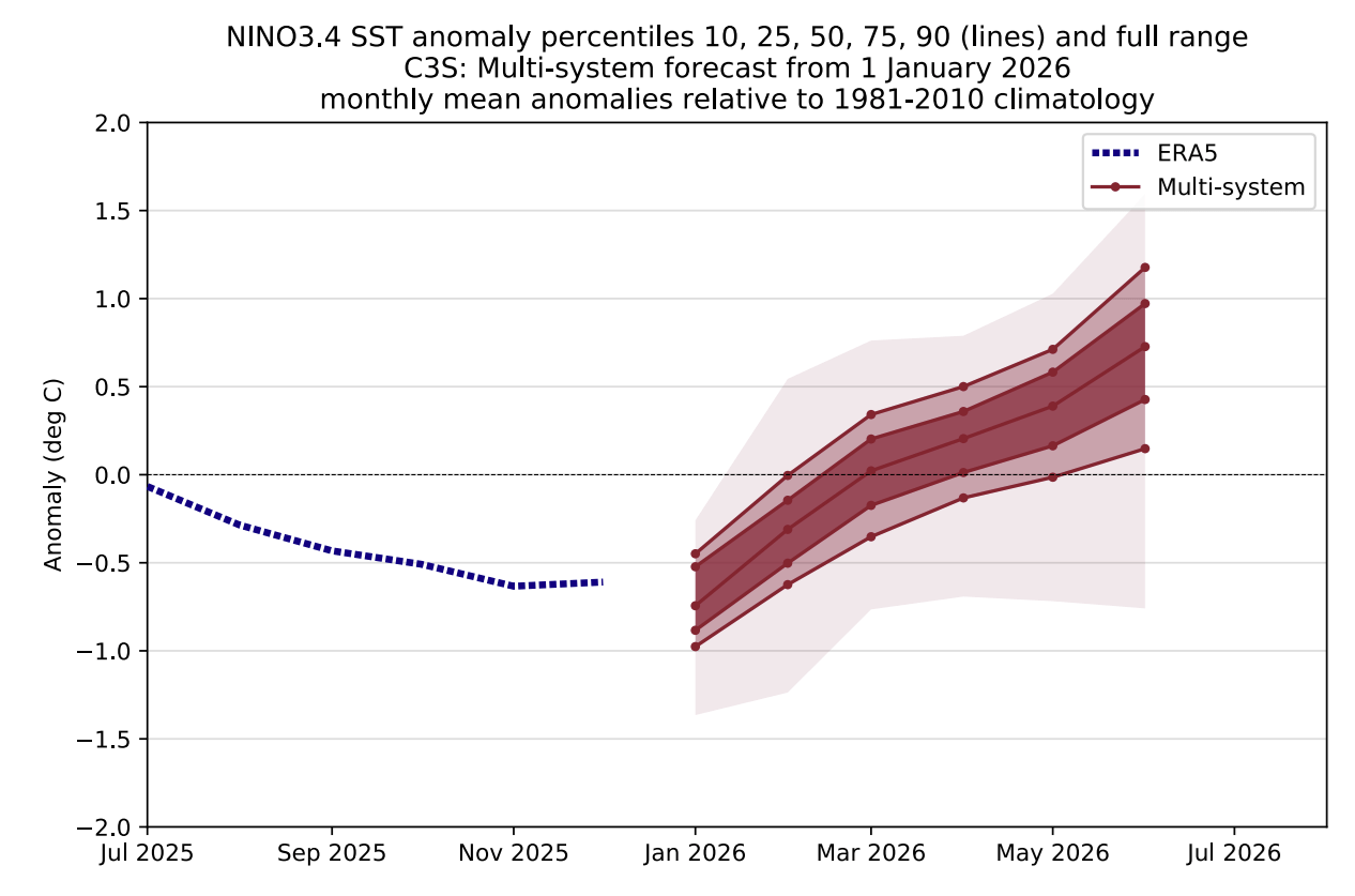
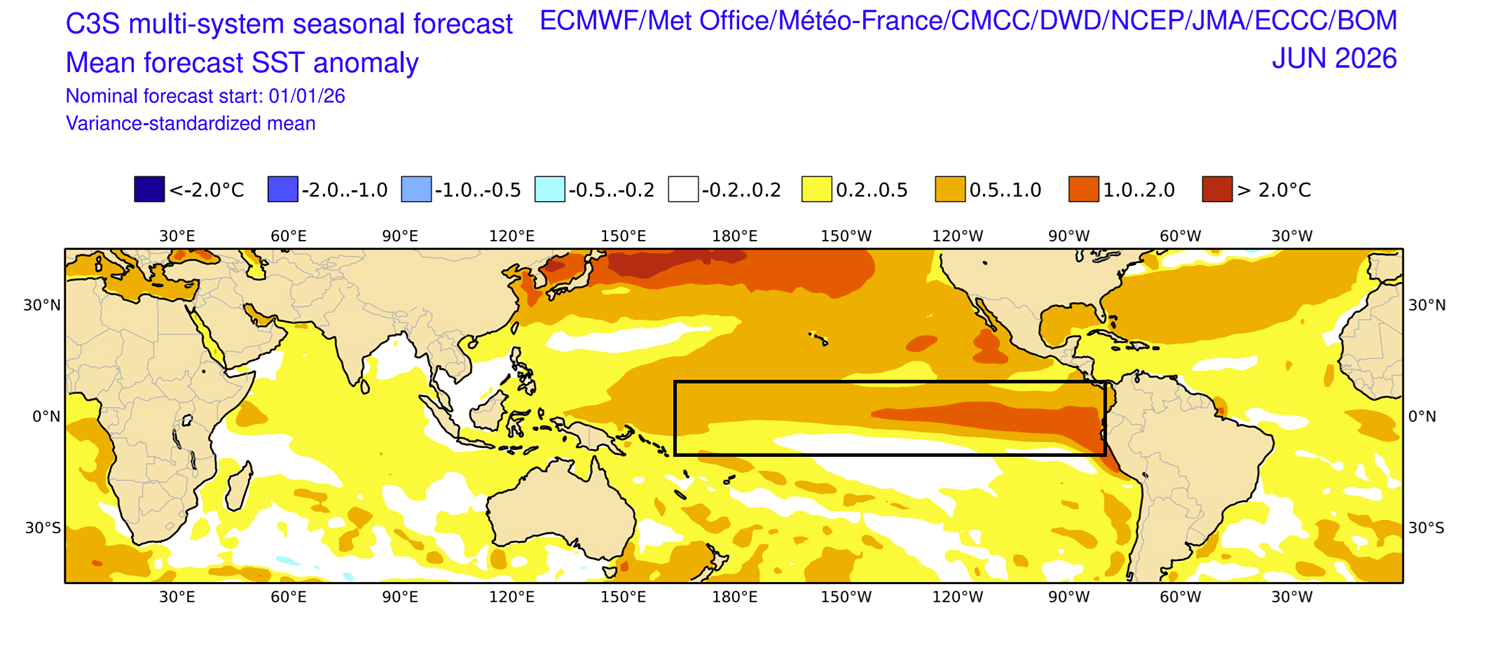
Below is the latest ENSO multi-model forecast for the next few months from the C3S system. It shows a rapid end of the La Niña and a rapid transition into an El Niño. Since this is a combined forecast from multiple long-range models, this is a high-confidence outlook. All the individual solutions agree on the end of La Niña and a shift into an early warm phase by Summer.
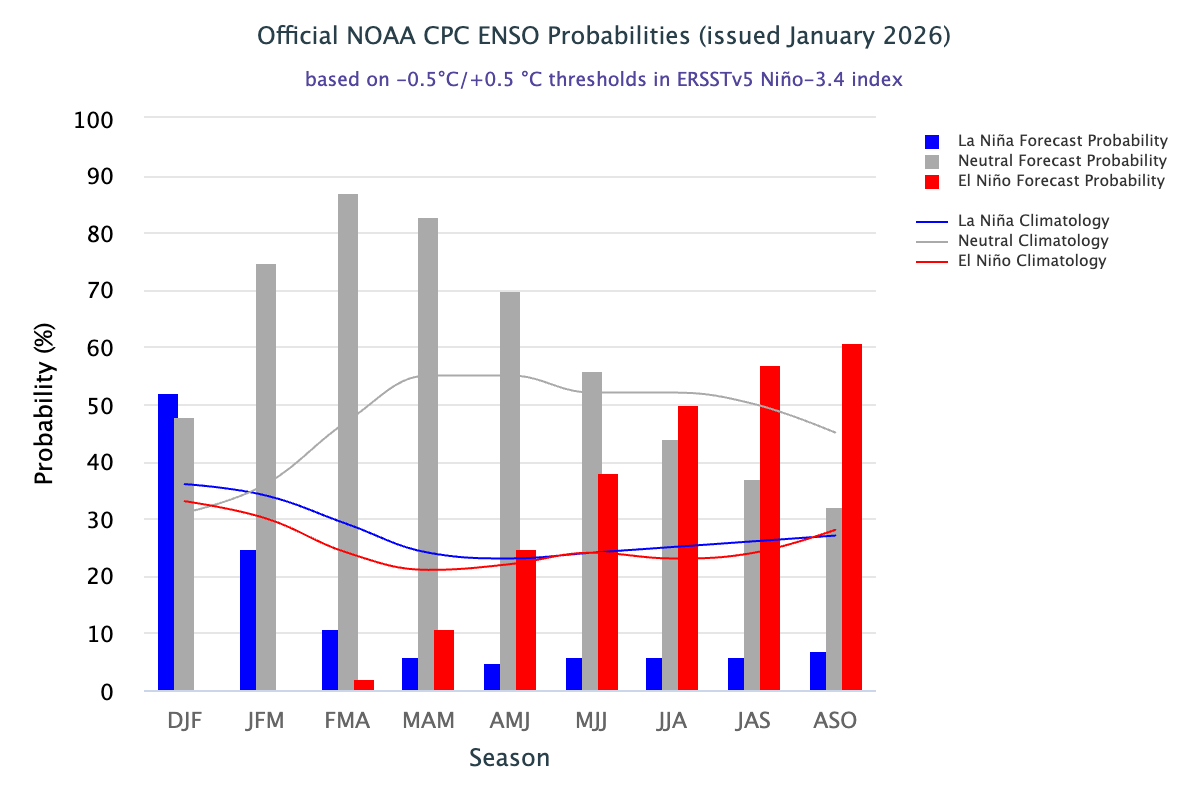
The IRI probabilistic ENSO forecast from NOAA-CPC data indicates a rapid end to La Niña and the emergence of El Niño during Summer. This means that El Niño is likely to peak during Winter, bringing its main impact during the 2026/2027 Winter season across the United States, Canada, and also Europe.
Looking at the latest multi-model forecast for June, you can already see a clear El Niño warm anomaly emerging across the tropical Pacific by Summer. This is not a full-blown El Niño yet, but it’s exactly what we would expect to see at this point in early summer, as the event starts developing fully by late Summer or early Fall.
All these forecasts show a very clear and rather rapid shift from a cold to a warm ENSO phase. This tells us that we are in for a strong global weather shift in 2026. We decided to look at some past data to find years with a similar shift from a weak cold ENSO phase into an El Niño, as is forecast for 2026.
Several years stood out in the data, and we decided to merge all the data together to see how the weather evolved in those years during late Winter and early Spring.
From Ocean to the Stratosphere: The Weather Disruption Begins
La Niña has a well-known atmospheric impact during the Winter and Spring seasons. This is also important when we transition from one phase to another, as the global weather system is re-adjusting.
Below is a late Winter/early Spring pressure anomaly pattern for years with a similar La Niña to El Niño shift, made with NOAA PSL tools. You can see a high-pressure blocking system over Greenland and the North Atlantic. This enables low-pressure over North America and Europe, bringing down colder air from the Polar regions.
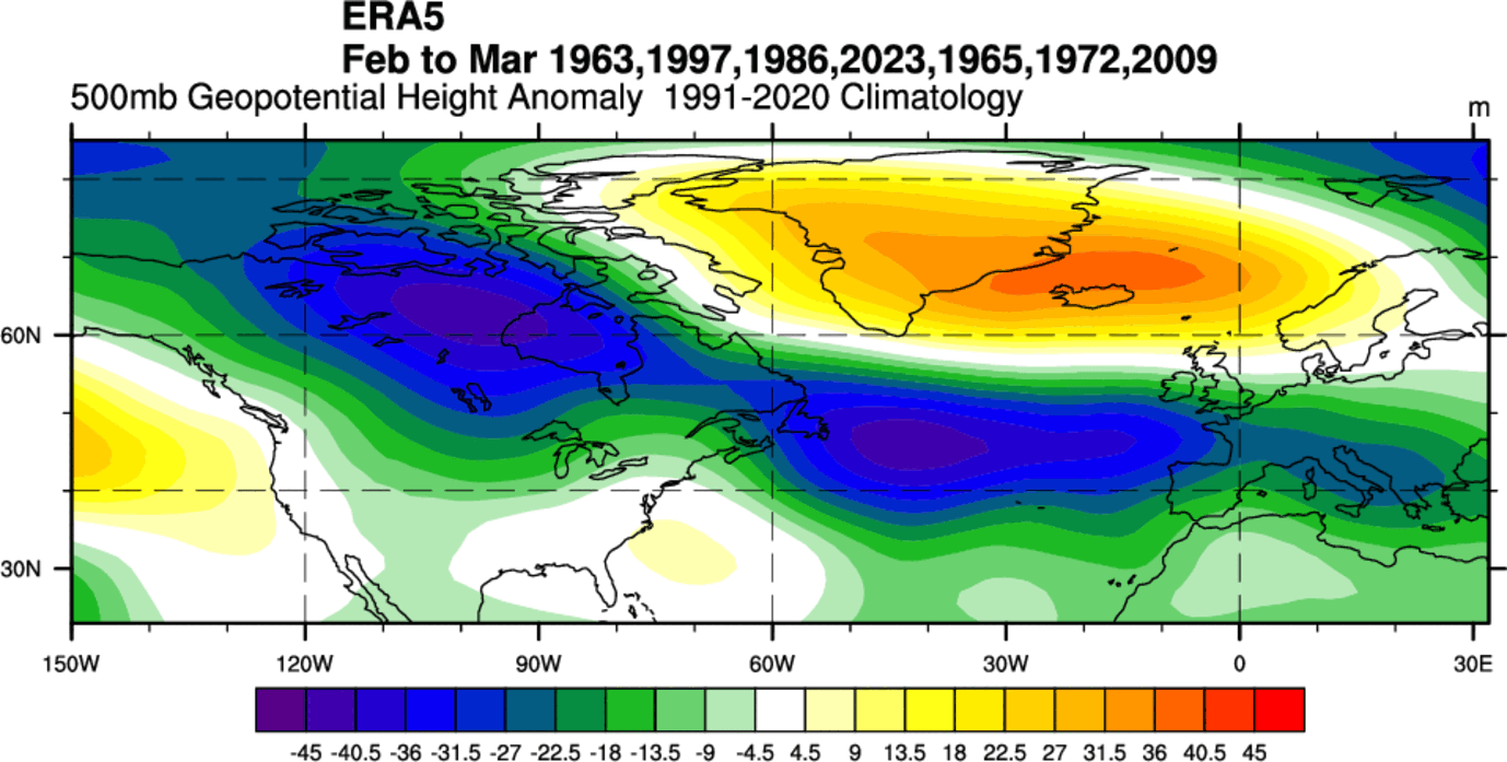
A low-pressure area over central and eastern Canada supports a more northerly flow, transporting colder air into the northern half of the United States. At the same time, a colder easterly pattern can develop over Europe.
If we look at the latest ensemble pressure forecast for February, you can actually see a very similar pressure pattern to that in the past years above. A high-pressure blocking system is over Greenland, with low-pressure systems spanning from western Canada, the United States, and the Atlantic into Europe.
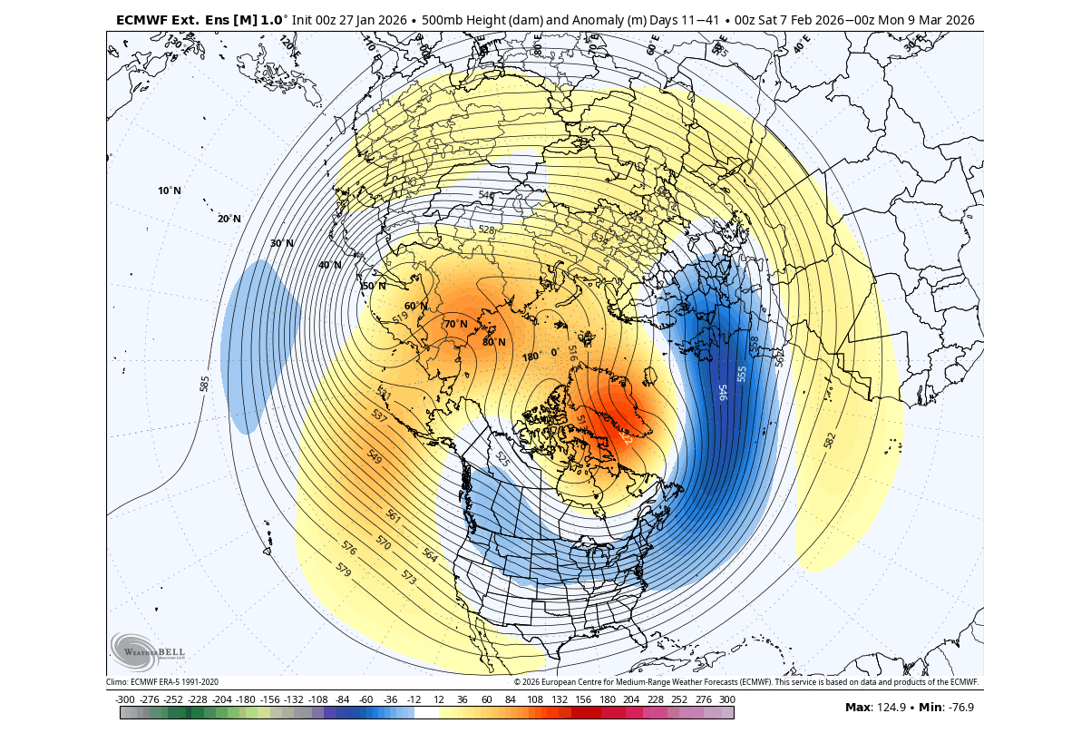
This is a supportive pattern for colder air transport into the United States and also for a cooldown over Europe. But at this point, we also have to add that this pattern will be powered by not just ocean anomalies, but by a Stratospheric Warming event in early February.
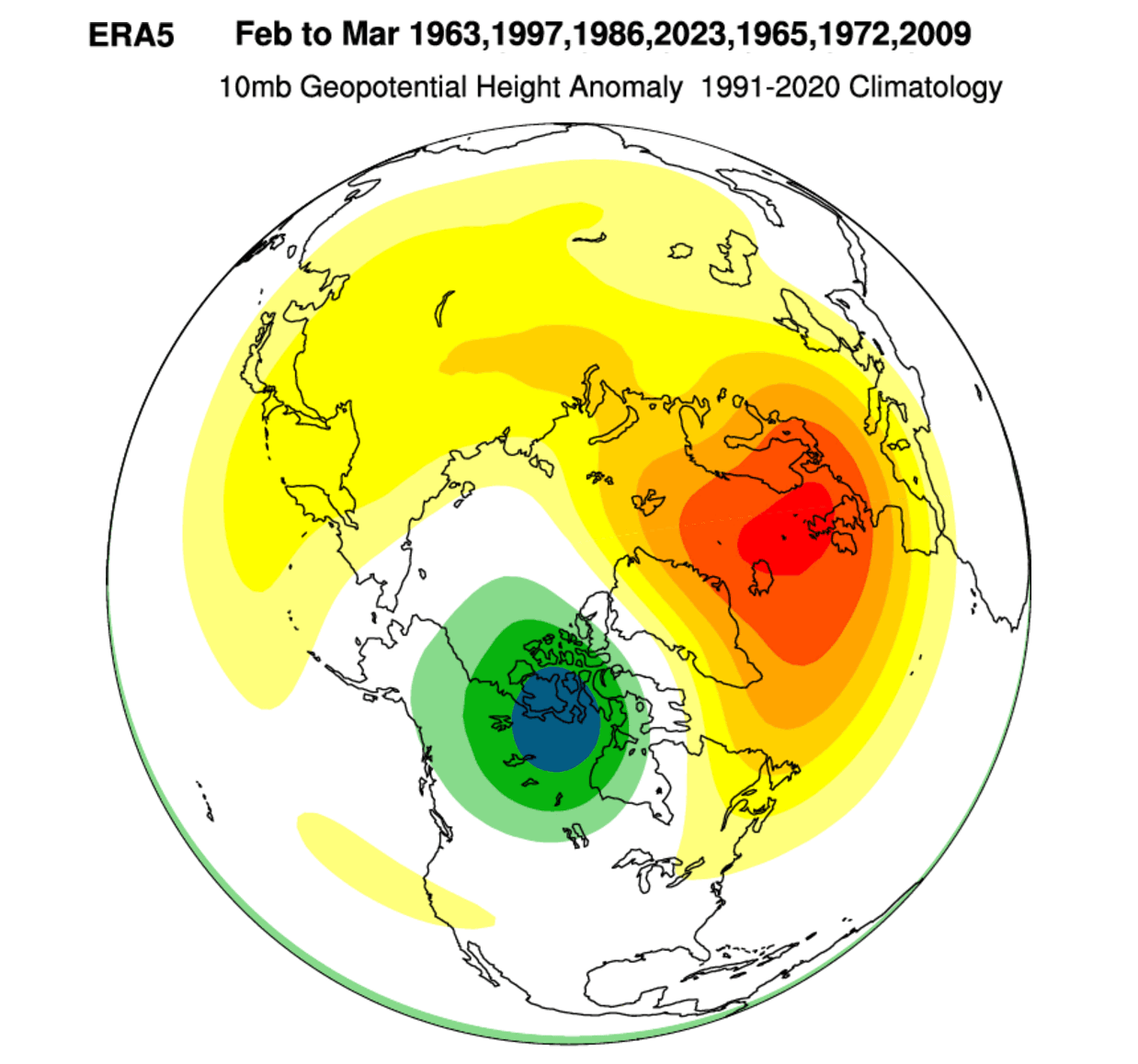
Below is the mid-stratosphere pressure anomaly forecast for the 10mb level (30km/18.5miles height) around February 10th. In this image, you can clearly see the powerful high-pressure anomaly in the mid-stratosphere, collapsing the Polar Vortex, splitting it into two separate cores, and changing the course of weather in February and likely into March.
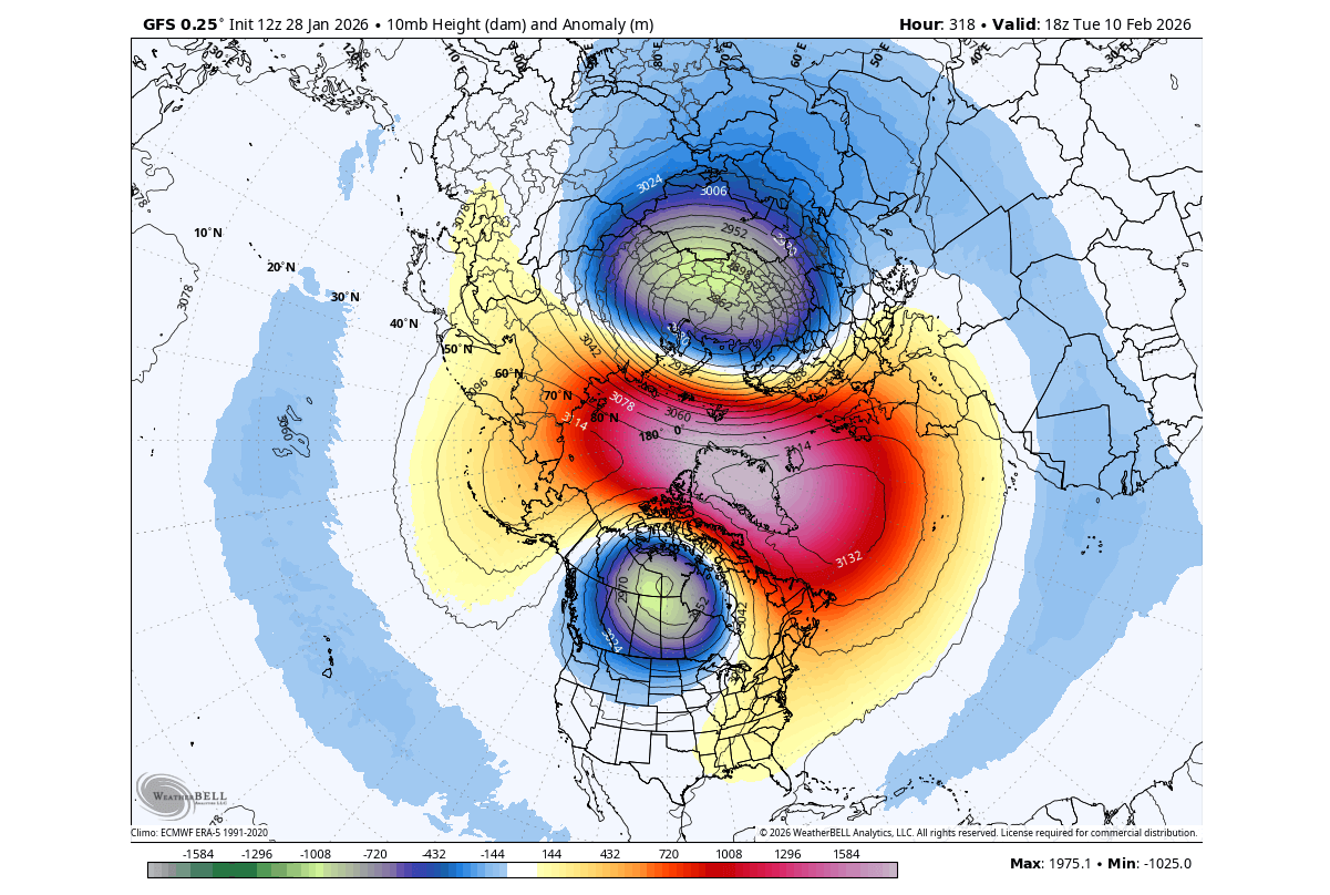
This event basically disrupts the pressure anomalies below, helping to create the high-latitude blocking pattern, with high-pressure over Greenland and Polar regions. This means that the cold polar air can escape more easily into the United States or Europe.
But if we look at the mid-stratosphere pressure anomalies for the same past years as above, we get a very interesting image. Below you can see that we also have a stratospheric warming signature in the past years with a rapid La Niña collapse. A disrupted Polar Vortex, with a remaining core over North America, just like in the 2026 forecast above.
This can tell us that some past years with the same ENSO shift also had stratospheric warming events at this time of year. That can also be a result or side-effect of the tropical patterns starting to change, helping to send energy into the stratosphere, disrupting the Polar Vortex.
Looking at the temperature for the past similar years, you can see a cold air anomaly over Canada, reaching into the northern United States. Keep in mind that this is a 2-month average, and it still shows a cold trend for the northern and eastern United States. Individual cold events can extend across the whole central and eastern United States.
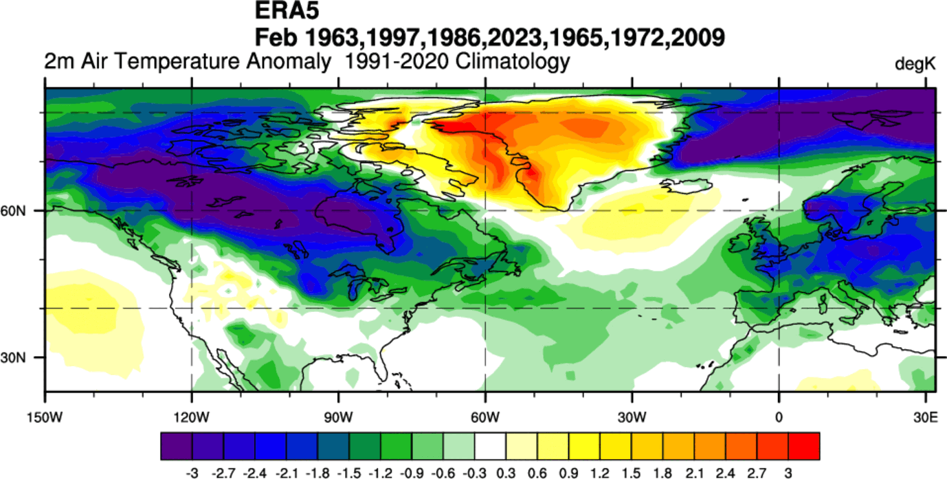
You can also see a colder signal over Europe, which is an expected result from the stratospheric warming events, and also from the shift in the global weather system. But again, this is a 2-month average from different years, so individual years can have a bit different placement of cold.
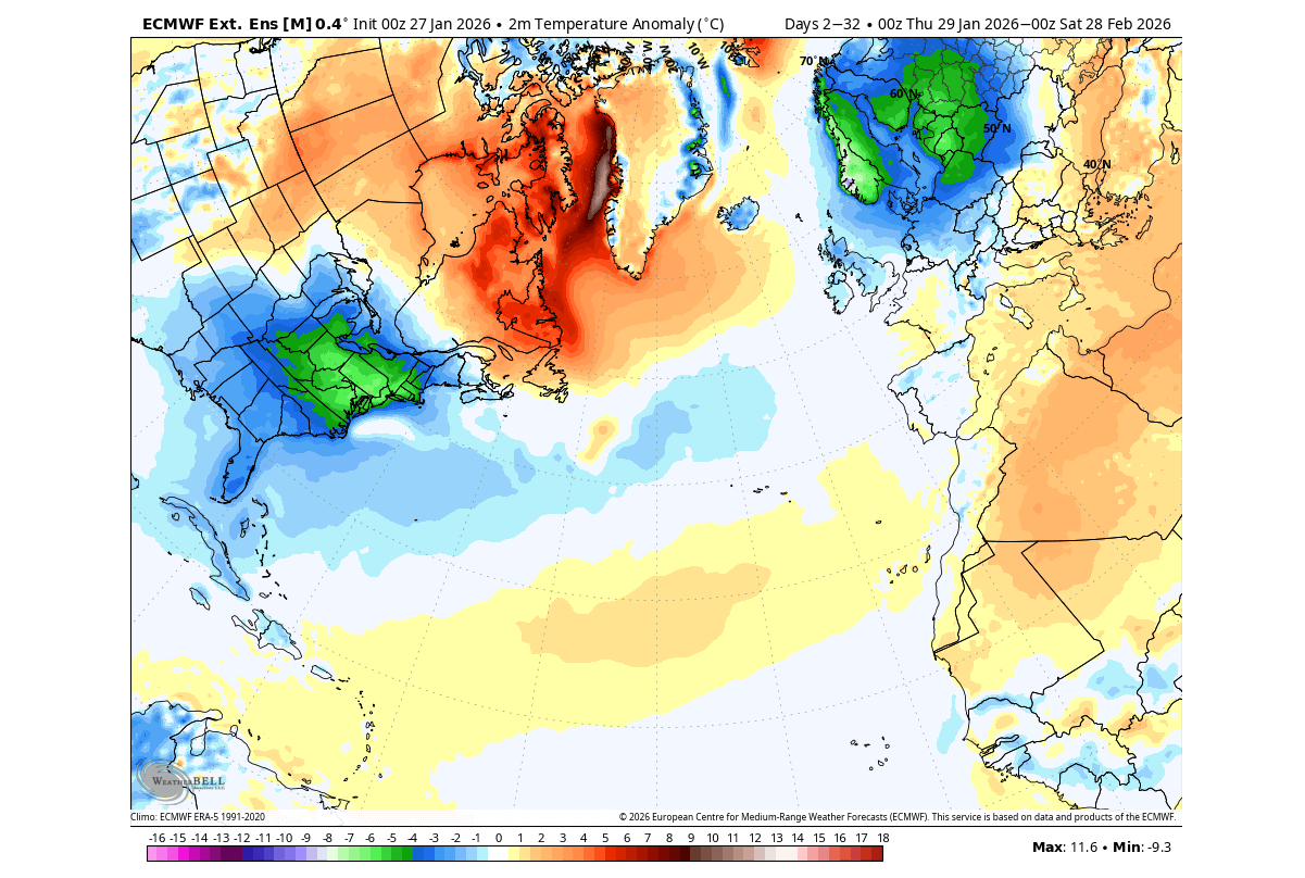
If we look at the actual ensemble forecast for February, you can see a colder trend emerging for the whole eastern United States. There is also an expanding cold area over the northern and north-central parts of Europe. This is an extended range ensemble forecast, so this trend will further adjust as the Stratospheric Warming materializes.
But overall, these images and data show us a very interesting, similar weather pattern in the past, present, and future, with connections across the oceans and different layers of the atmosphere.
Of course, 2 years never have the exact same weather, despite similar events like the La Niña collapse and the Stratospheric Warming. But what the data shows is that on average, these events are likely connected, and have a tendency to create a specific (colder) weather pattern in late Winter and early Spring.
But what weather patterns can we expect once the La Niña is fully gone, and a new El Niño appears?
The Winter 2026/2027 Preview: Will El Niño Return with Cold and Snow?
The long-range ocean forecasts above show that the El Niño event will likely emerge during Summer, which would bring its first clear atmospheric impact by the 2026 hurricane season. It is too soon for any real hurricane forecast, but we can look at the past data for the El Niño influence on hurricane season.
Looking at precipitation data, you can see much less precipitation in the main development zone during an El Niño. The south coastal areas of the United States, the Caribbean, and most of the tropical Atlantic are drier than normal, indicating that El Niño is preventing major tropical development or hurricane landfalls.
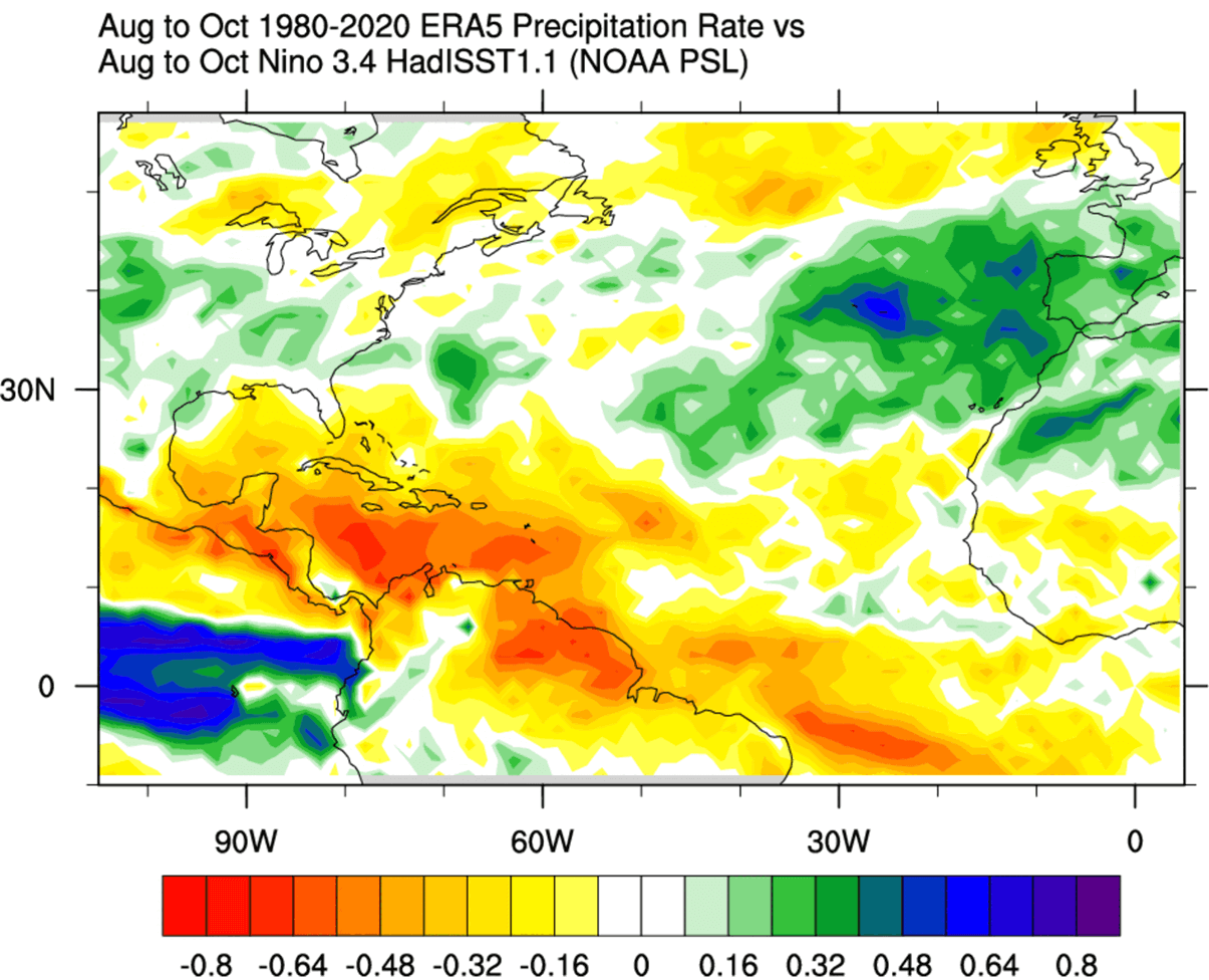
This is mostly a result of higher pressure and more stable conditions across the tropical Atlantic. This means fewer tropical storms and weaker systems. So, an El Niño can greatly reduce the chance of strong hurricanes impacting the United States.
But the biggest weather impact is usually during the Winter season, and here the El Niño has a completely opposite influence to a La Niña.
Below, we produced three images that show the El Niño winter anomalies in past years from the ECMWF ERA-5 dataset. We first used the same years as above for the February/March forecast, but no we can simply look at how all those years advanced into winter with an active El Niño.
The data shows that El Niño winters in similar years were warmer than usual across Canada and parts of the northern United States. At the same time, colder temperatures prevail over the western, southern, and eastern United States.
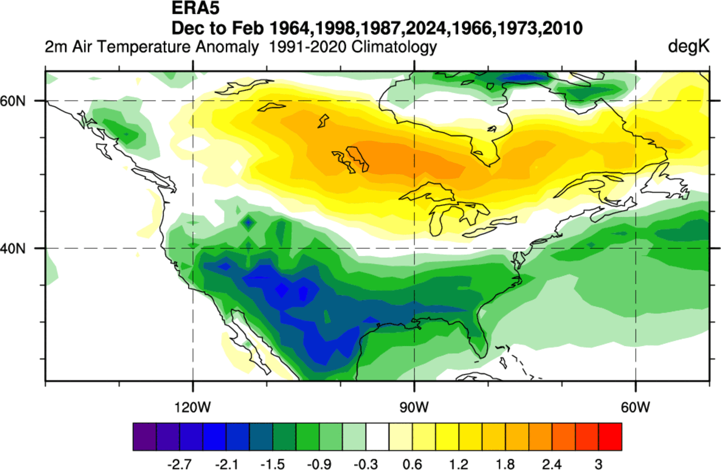
This appears to be a more typical El Niño winter pattern, with the difference that in these specific years the colder temperatures covered more of the western and eastern United States than in an average El Niño cold season.
As you can see in the image below, an El Niño event also changes the snowfall patterns. The data shows less snowfall in the northern United States and the Midwest during an average El Niño winter. But we see snowfall over eastern Canada, in the central and southern United States, across the Plains, and also over the eastern United States and into the Northeast.
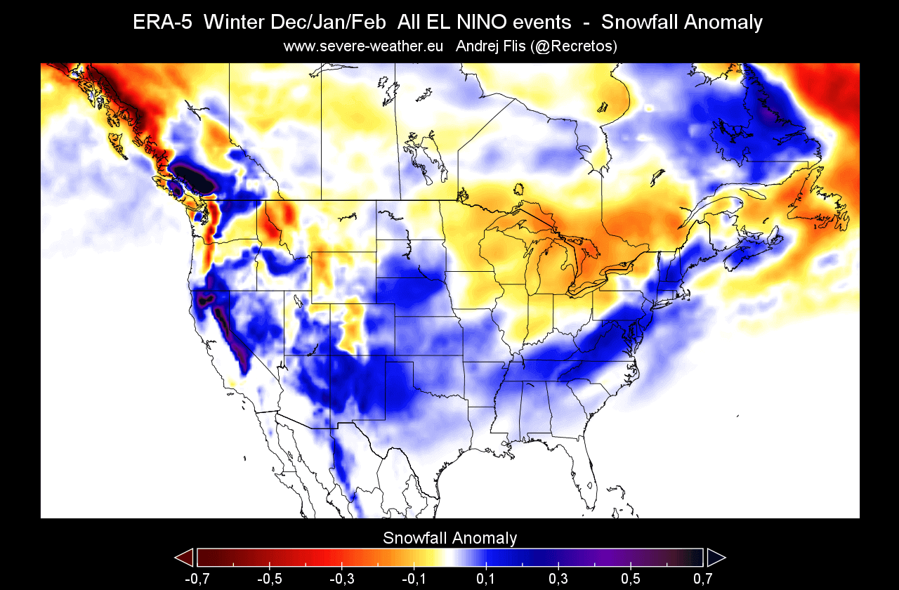
This is because low-pressure systems are trailing across the southern United States in an El Niño. With cooler air and moisture (if available), the chances of snowfall increase in the southern half of the country and towards the east. But a lot depends on the availability of the cold air from the north.
We can also see less snowfall over the Midwest, but that is likely associated with a lack of precipitation overall in this region, very typical for an El Niño winter.
Europe also feels the impact of an El Niño in winter, but much less directly, as it’s further away from the main ENSO region. And also, there are a lot of pressure systems and interference in the North Atlantic.
But looking at the temperature anomalies for Europe, the specific years show a cold winter trend over the northern parts of the continent, spreading ocasionally down into the western and central part. Keep in mind that there are some older and colder winters in this combination of years.
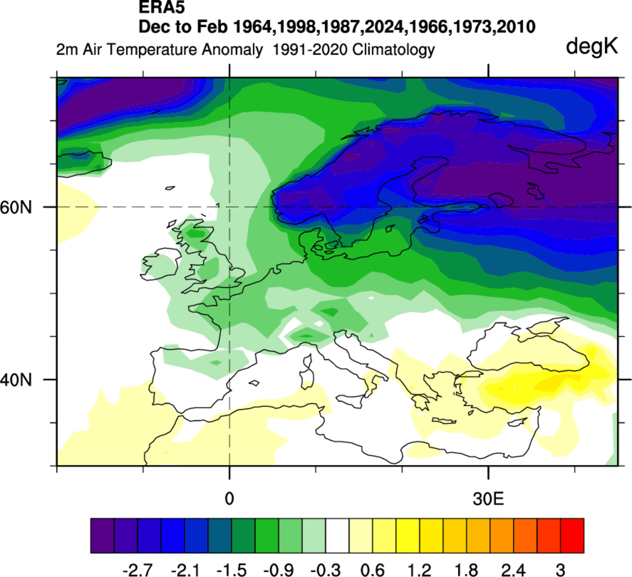
We do have to consider that Europe is usually not under a direct El Niño influence, but can still experience the changes on a global level, which affects the weather patterns in the Northern Hemisphere.
Forecast images in this article are from cyclonicwx.com and WeatherBell, using a commercial license.
We will keep you updated on global weather development and long-range outlooks, so bookmark our page. Also, if you have seen this article in the Google App (Discover) feed, click the like (♥) button to see more of our forecasts and our latest articles on weather and nature in general.
Don’t miss: