The unseasonably warm weather across Canada and the United States is soon ending. A more progressive weather pattern will develop across North America through mid and late February. A significant winter storm, Kayden, will impact the Northeast U.S. and Nova Scotia, Canada, with deep snow and blizzards around Valentine’s Day. More than a foot of snow will blanket the corridor from Pennsylvania through the northern New York City metro area to Boston and across Nova Scotia, impacting tens of millions with blizzard conditions and impassable roads.
A significant winter storm development is expected across the Northeast U.S., accompanied by strong winds and heavy snowfall. Many areas will experience blowing snow, which will reduce visibility. Travel will be difficult because of the combination of snow and winds, leading to blizzard conditions.
The new storm system will produce snow from the Mountain West to the Northeast, with snow reaching western Texas and Oklahoma Sunday night, then continuing across the mid-Mississippi Valley to Ohio Valley.
Following Monday, deep snow will blanket parts of the Northeast, including parts of the New York City metro area and Boston. Winter storm watches have been issued for the Northeast, including State College, Hartford, and Boston, where roads may become impassable and travel difficult.
Conditions will deteriorate rapidly and become dangerous Monday night into Tuesday as winter storm Kayden intensifies further and tracks northeast; blizzard conditions will spread across the Northeast states.
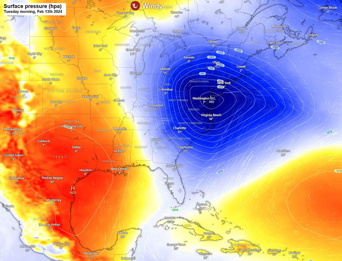
The frontal system will travel across the Northeast on Monday and Tuesday while intensifying into a Nor’Easter towards Nova Scotia, Canada, significantly impacted by a major snowstorm last week. To the south of the center low, rain will spread across the mid-Atlantic states early Monday. Once the colder air arrives Monday night, the rain will turn to snow, along with the deepening of the surface depression.
Further south, across the Southeast U.S., the warm influx of moist sub-tropical air mass from the Gulf Coast will develop severe thunderstorms that could bring severe winds, tornadoes, and flash floods.
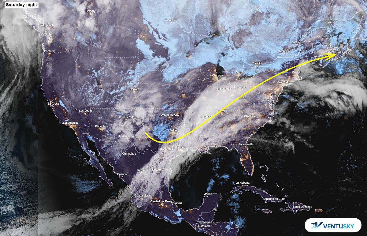
Over the weekend, the satellite across North America reveals an impressive frontal zone extending from the East Coast across Texas to Mexico. To the west of it, a new upper core is shaping up. The yellow line indicates the approximate path of the new winter storm developing Sunday night, tracking towards the Northeast U.S. by Tuesday.
The attached video summarizes the rapidly deteriorating winter storm conditions and Arctic cold developing across Canada and the U.S. in the following 10 days. The surface low continues deepening as Nor’Easter develops a major snow and blizzard impact for the Northeast U.S. and Nova Scotia.
As the system tracks towards the Northeast on Monday, the cold front brings significant weather and severe thunderstorms potential for the Southeast U.S. and East Coast. In the wake of winter storm Kayden, a much colder Arctic air mass will gradually spread south next weekend and through late February.
Before we head into deeper details regarding the potential evolution of the winter storm Kayden next week, let’s have a quick overview of the trigger behind these weather systems. The Polar Vortex above us is responsible for significant winter weather events in the northern hemisphere, including North America.
Here is why it is essential to know when we track our daily weather.
What is the Polar Vortex
Our atmosphere is built of six layers around our planet. The majority of the dynamics for our daily weather occur in the lowest two layers. Those two are known as the troposphere and the stratosphere layers.
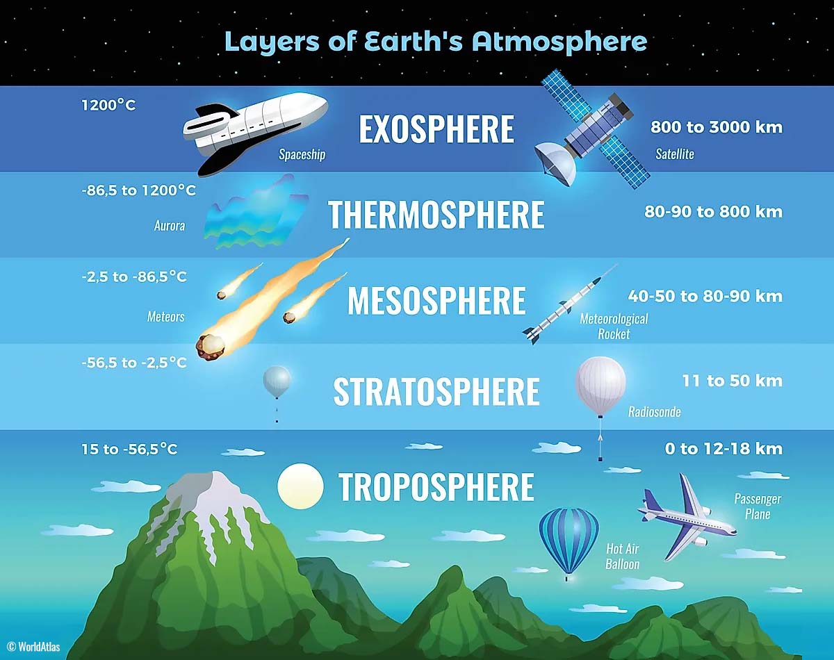
The layer that is the closest to the Earth’s surface is the troposphere. It is about 12 km deep layer, extending from the ground up high into the sky. The depth of it varies from around 8 km to almost 20 km, depending on where you live. The troposphere is the deepest above the equatorial region but gets much thinner above the North and South poles.
Above this layer is a much deeper one known as the Stratosphere. It is an 11-50 km thick layer with very dry air. The stratosphere also has the ozone layer, vital in protecting our planet’s life against the potential impact of solar storms from the Sun or outer space.
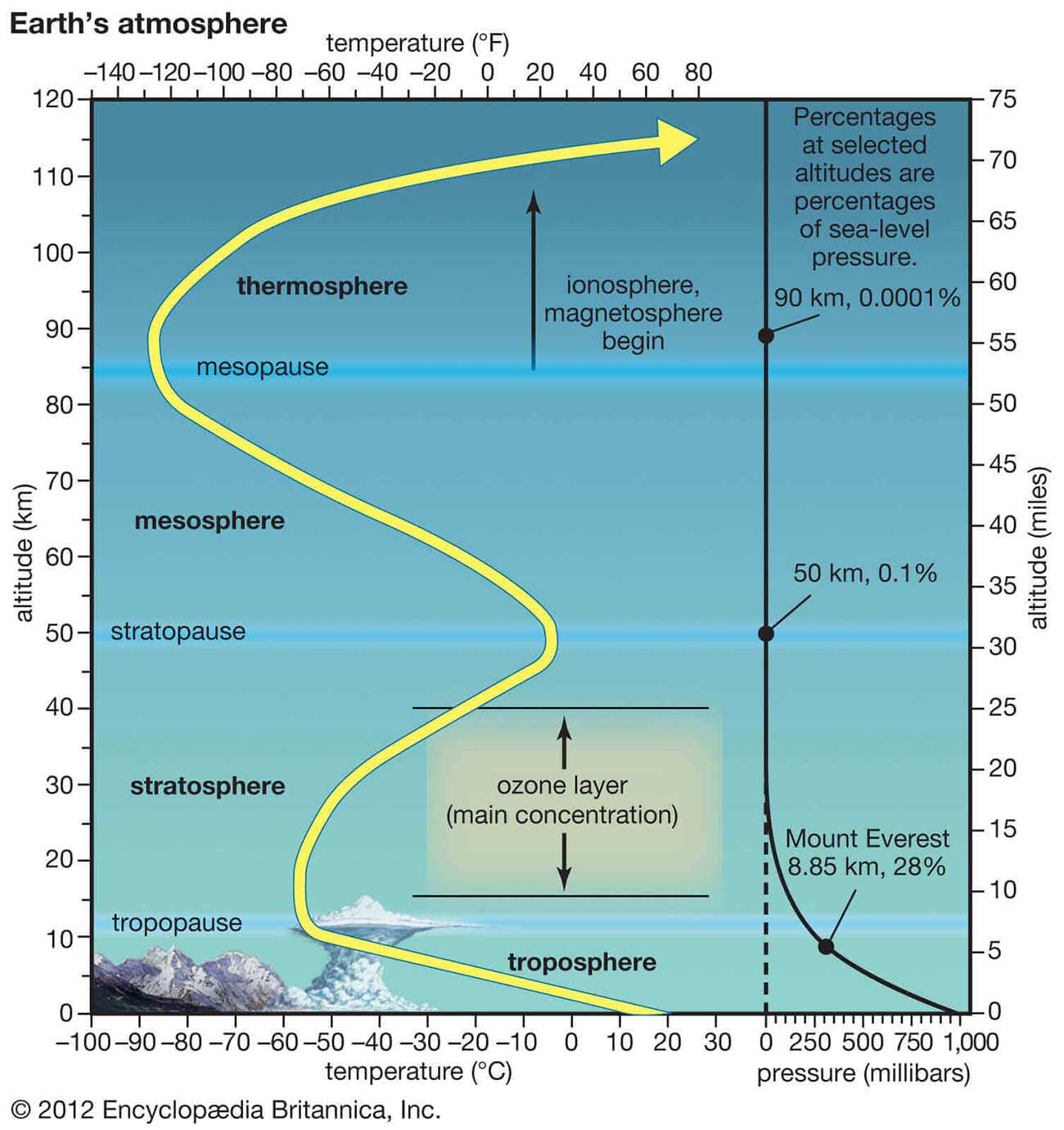
Another essential feature in the stratosphere, which makes our weather even more variable, often triggers significant large-scale weather events. This is the Polar Vortex, an enormous, tri-dimensional ring of powerful winds moving through the sky above us. The Polar Vortex is spinning around the North Pole, grazing through the air at about 20-50 km above the Earth’s surface with violent wind speed.
The troposphere and the stratosphere are crucial for our climate, as the Polar Vortex covers most of the bottom half of the atmosphere. Since the vortex extends from the middle of Earth’s troposphere up into the stratosphere layer, it has the main major effect on the winter weather across the high and mid-latitudes yearly.
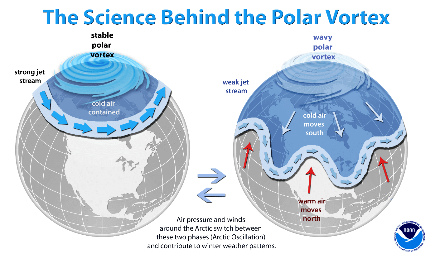
We could experience this in Canada, the U.S., and recently in northern Europe and Asia as the vortex has been disrupted and shifted on the other side of the northern hemisphere.
The Polar Vortex is the strongest during winter in both the Northern and Southern hemispheres. Although it spins well above our heads, it remains closely connected with the lowest parts of our atmosphere. Thus, it leads to our daily weather shape in many different ways, as it generally works as one sizeable hemispheric circulation.

The Polar Vortex above us has triggered all the dynamic weather systems, from the frigid cold outbreaks and winter storms in Canada and the United States to the lack of winter weather and snow in other parts of the northern hemisphere.
How does the Polar Vortex form, and why does it strengthen?
During the fall months, the polar regions receive much less energy from the Sun. This way, the cooling over the northern regions becomes more robust, and as a result, polar nights also occur for several consecutive months, with days without any sunlight following.
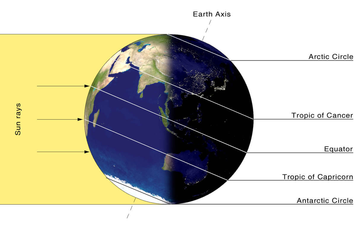
While the temperatures in the polar region are dropping into deep freeze, the atmosphere layers farther to the south are still relatively warm as they receive more of the sun’s energy simultaneously. Therefore, the south’s equatorial layers remain much warmer than the areas farther north. So, this leads to a high-temperature contrast between them.
Cooling the polar regions also lowers the ambient surface pressure, with a similar weather process also happening in the stratosphere layer. Therefore, the temperature difference between the North Pole and the equatorial areas increases across both layers. This creates a large low-pressure cyclonic circulation across the polar stratosphere, where this feature became famous – the Polar Vortex.
Putting all these puzzle pieces together, the Polar Vortex is an enormous cyclone in our atmosphere. It expands across the North Pole during winter and sometimes becomes very intense, extending south to the mid-latitude regions. The same is also happening in the southern hemisphere during their winter period as the Polar Vortex intensifies around the South Pole.
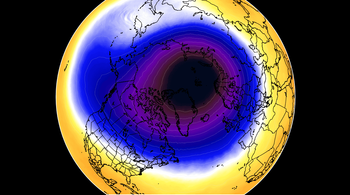
The weather model chart above hints at a very typical situation of the Polar Vortex fully established above us, representing the pressure at around 30 km (18 miles) altitude. This area is near the top of the stratosphere layer during winter.
The active and strong Polar Vortex during the Winter season 2023/24 has been the main trigger behind the frigid cold outbreaks over Siberia in December and the historic Arctic cold blast into Canada and the U.S. through the first half of January.
In early February, the most intense part of the vortex, its southern lobe, is gradually shifting towards the North American side of the northern hemisphere once again.
A profound new wave emerges from Canada into the Northeast U.S. Winter Storm Kayden forms
The general weather picture across North America through mid-February indicates a new deep upper-level wave digging south from Canada into the eastern Contiguous U.S.
By early next week, the wave will gradually become a relatively small upper low and move towards the Mid-Atlantic and Northeast U.S.
This wave will significantly disturb the upper levels, developing a significant winter storm Kayden across the eastern U.S. The system will bring colder air mass in its wake, clashing with moist and warm air from the Gulf Coast region northwards.
Thus, significant winter weather around the storm’s core and severe thunderstorms on the front side. The following chart represents the upper-level winds where a deep wave disturbance with violent high-level winds spread across the Southeast United States.

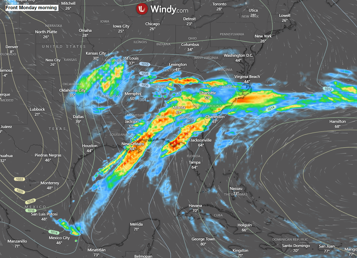
In response to gradual high falls in the upper levels as the low digs this far south, the pressure falls will lead to surface cyclogenesis from the southern Rockies towards the mid-Mississippi Valley on Monday, strengthening further east towards Northeast states early Tuesday.
The low will be pumping vast amounts of moisture from the Gulf towards the surface frontal system and, simultaneously, a much colder air mass in its wake from the Great Lakes region. Thus, the front will intensify with significant severe weather Monday night into Tuesday.
Snow will gradually spread from West Texas to Oklahoma early Monday, then continue towards the mid-Mississippi Valley by the afternoon. Conditions will worsen Monday night with developing blizzard conditions as the low deepens across the Ohio Valley and tracks towards the Northeast.
Conditions will deteriorate with time as the system continues deepening its central pressure and intensifying further on Tuesday as it tracks across the Northeast U.S. towards Nova Scotia.
Ahead of the cold front, a large unstable warm sector will develop thunderstorms with potential tornadoes, damaging winds, and flooding for the South and Southeast U.S., rapidly moving east along the Gulf Coast.
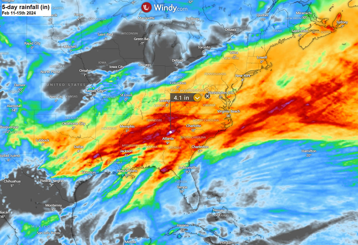
A swath of multiple rounds of storms will result in high rainfall along the Gulf Coast and the Southeast U.S., with high amounts of rain likely to expand across the East Coast and Mid-Atlantic Monday into Tuesday as the winter storm progresses further northeast.
Around 3-5 inches of rain could accumulate in some areas, leading to flooding potential, from the lower Mississippi Valley across Northern Alabama and Tennessee towards the Carolinas.
Heavy thunderstorms will also produce flash floods potential during the main cold front passage from Monday afternoon into early Tuesday, besides the other potential threats, such as tornadoes and potentially damaging winds.
Winter storm Kayden, with heavy snow and blizzard, will blast the Northeast U.S. on pre-Valentine’s Day, then Nova Scotia
When the deep upper wave digs south U.S. enough, it intensifies the surface low that will eject towards the East Coast on Monday. With the help of a strong jet stream rounding the base of the upper core, the development of the surface disturbance will be pretty fast.

The following two charts indicate the position of the frontal system on Monday night (left) and Tuesday midday (right). A developing snowstorm will spread from the central Plains and mid-Mississippi Valley towards Tennessee Valley by the evening hours.
Then, a swath of heavy snowfall and blizzard conditions will gradually develop Monday night into early Tuesday across the lower Ohio Valley towards Pennsylvania. Becoming more widespread and intense on Tuesday daytime across the Northeast states with intense blizzards underway.
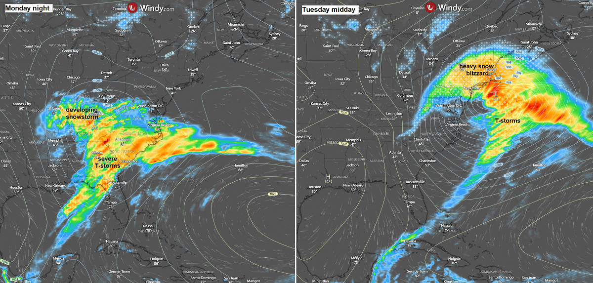
Farther south along the cold front, there will be a swath of severe thunderstorms across the Southeast states and towards the East Coast from Monday afternoon through Tuesday morning.
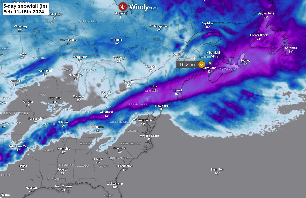
The amounts of snow will be the highest across Pennsylvania, New York, Connecticut, and Massachusetts, including the New York City metro area, New Haven, Hartford, and Boston. The most significant snow depth will develop where the interaction of the moist southerly air mass and cold Arctic air mass from the north will be sharpest.
A swath of snow with 10 to 20 inches accumulated will likely spread from central Pennsylvania and New York to Massachusetts, with most snowfall falling within 24 hours of winter storm Kayden’s passage.
The most significant snowfall will be along the northern edge of the strengthening surface low as it tracks northeast early Tuesday morning. Blizzard conditions will result in strong to severe winds in sharp pressure and temperature contrast. Significantly reducing visibility with whiteout conditions is likely to be expected, with many roads across the Northeast becoming impassable.
Expect significant travel disruptions on Tuesday, the pre-Valentine’s Day.
The following chart of peak winds on Tuesday indicates strong to severe winds will develop along the Atlantic coast as Nor’Easter deepens across the Northeast. The highest winds will, however, remain off the coast, with gusts around 80 mph. However, strong to severe winds will also impact Cape Cod and the Bay.
Conditions will be intense through most of Tuesday.
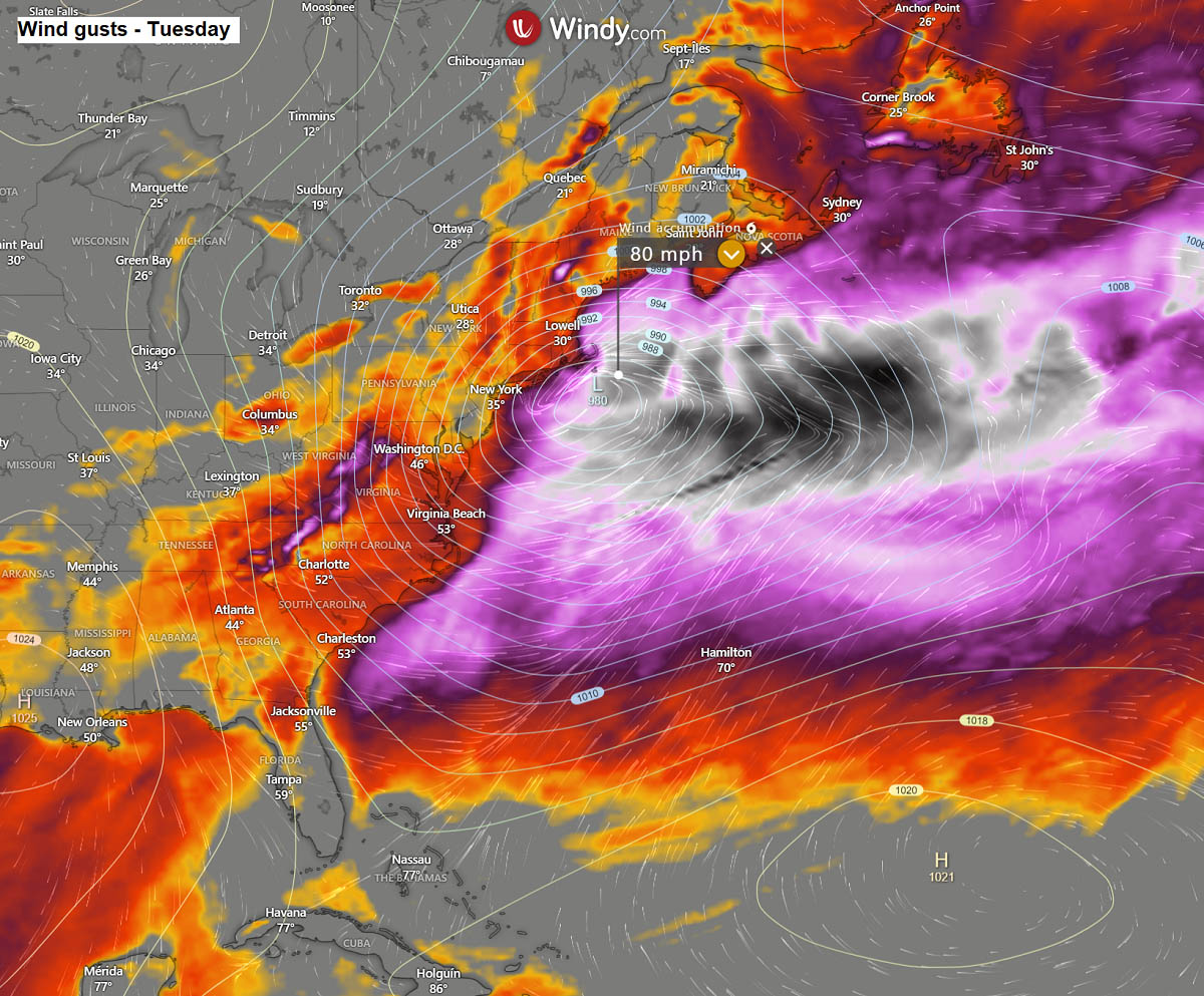
The core of Tuesday’s further developing Nor’Easter storm, associated with a solid and robust cold frontal boundary, will extend from New England towards Nova Scotia, Canada. Very heavy snowfall will spread the peninsula once again, accompanied by intense blizzard conditions.
Winter Storm Kayden could dump more than 20 inches of fresh snow within 24 hours from midday Tuesday through Wednesday morning across Nova Scotia. Causing more trouble for the region. Roads will be blocked, and travel will be nearly impossible as a significant impact of strong winds and downpouring snow will emerge.
Next weekend, the potential increases for a new deep Arctic cold outbreak in Canada and the United States
The Winter Storm Kayden will be rapidly ejecting off the Northeast United States, moving across Nova Scotia and significantly impacting Newfoundland on Wednesday. While the weather will improve in its wake, the further deformation of the Polar Vortex aloft will flip the general weather pattern across North America.
The mid-term weather forecast indicates a solid blocking pattern will gradually establish across the North Pacific, Alaska, and Arctic Canada. This generally means a more meridional, northerly flow would be established over Canada towards the United States.
In short, the global weather model consensus is in good agreement for another potentially significant Arctic outbreak that could develop from the north around the following weekend.
The following chart for the Pacific and North America hints at this large and deep upper wave/low placed over central Canada and the U.S. following Monday. This is usually a sign that a mighty cold will likely develop.

The cold outbreak is forecast to develop over the following weekend, with a significantly colder Arctic air mass spreading across most of Canada and the north-central United States from the weekend through late February.
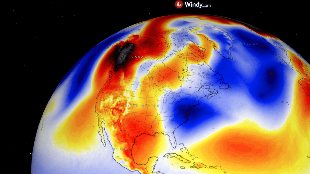
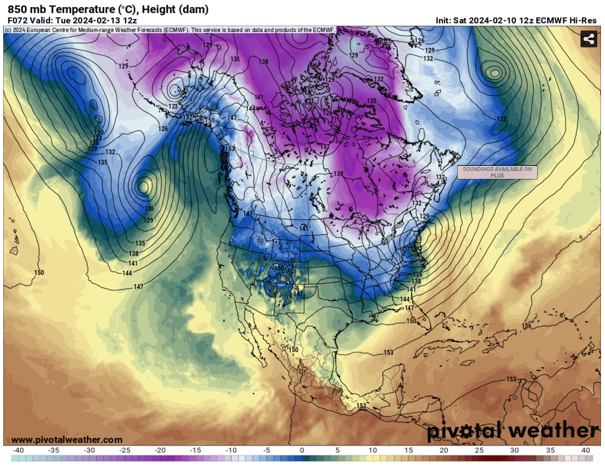
The mid-range weather charts indicate an impressive temperature anomaly across the Northern CONUS and Canadian Prairies through around Friday next week, intensifying through the weekend. Then, another push of even colder air mass will likely follow by Monday and Tuesday, with an ‘off the charts’ temperature anomaly.
The anomaly charts suggest temperatures could be spiking more than 25 °C below average at the 850 mbar level. This means frigid cold surface temperatures, resulting in days lasting cold, far below freezing, with the lowest temperature in the -30 °F range across the northern U.S. and south-central Canada.
The Arctic cold will also gradually spread east and south across the United States after the following weekend and could extend through the remainder of February.

The most aggressive weather model is the European ECMWF for now, while the GFS model is lagging this change by two days. Nonetheless, both model’s consensus hints that a new Arctic cold blast is coming next week.
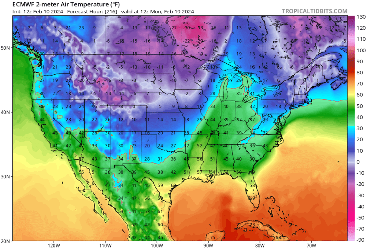
Attached is the 2m temperature anomaly for Monday morning, February 19th. The temperatures are forecast to be extremely low. About 30 degrees C below average, 40-50 °F colder than usual.
This results in dangerous, frigid cold conditions for southern Canada and the northern U.S., combined with very low wind chills.

Temperatures from Sunday through Tuesday will be very low, with some areas having daily low temperatures below -30 °F (-35 °C), especially across central and southern Canada.
Temperatures will remain far below freezing, about -10 to 20 °F in the morning and 0 to -10 °F during the day.
While the south and central U.S. might initially stay in relatively mild conditions, the large Arctic cold pool will likely spread east and south through late February, as the weather model forecasts suggested.
The long-term projections hint that the Arctic cold could persist well into the week after, through late February, and gradually expand across large parts of Canada and the United States.
How far south and intense the cold would be is yet to be determined as these charts show more than 7 days ahead of now. But the weather model consensus is entirely aligned that a significant cold is shaping up on the horizons.
We are closely monitoring the evolution of the weather pattern and plan to update the forecast in the coming days when details about the potential Arctic outbreak will be better defined on the weather models. Stay tuned.
Wxcharts, Windy, and Pivotalweather provided images used in this article.
See also: