The Polar Vortex is starting to power up and will drive a weather pattern change in the coming days, creating warm conditions over the United States and Europe. But its power-up will be quickly followed by a disruption event. A strong stratospheric warming wave is forecast to emerge, putting a question mark on the weather patterns for the rest of the Winter season.
Weather and the stratospheric Polar Vortex are strongly connected, especially in Winter. So it matters greatly in what shape or form the Polar Vortex is as we go through the season.
We will look at the important role of the Polar Vortex during the Winter season and how it played into the recent cold outbreaks. But more importantly, we will look closely at the latest forecasts and why the Polar Vortex might be the deciding factor for the weather patterns for the rest of the Winter season.
WEATHER CIRCULATION, TOP TO BOTTOM
As we head into autumn, the polar regions start to cool. This is because the Sun gets lower, and less energy reaches the North Pole. But as the polar temperatures drop, the atmosphere further to the south is still relatively warm as it still receives energy from the Sun.
This causes a strong temperature difference between the polar and sub-tropical regions, and a large low-pressure (cyclonic) circulation starts to develop across the Northern Hemisphere. It extends from the surface layers far up into the Stratosphere. This is known as the Polar Vortex.
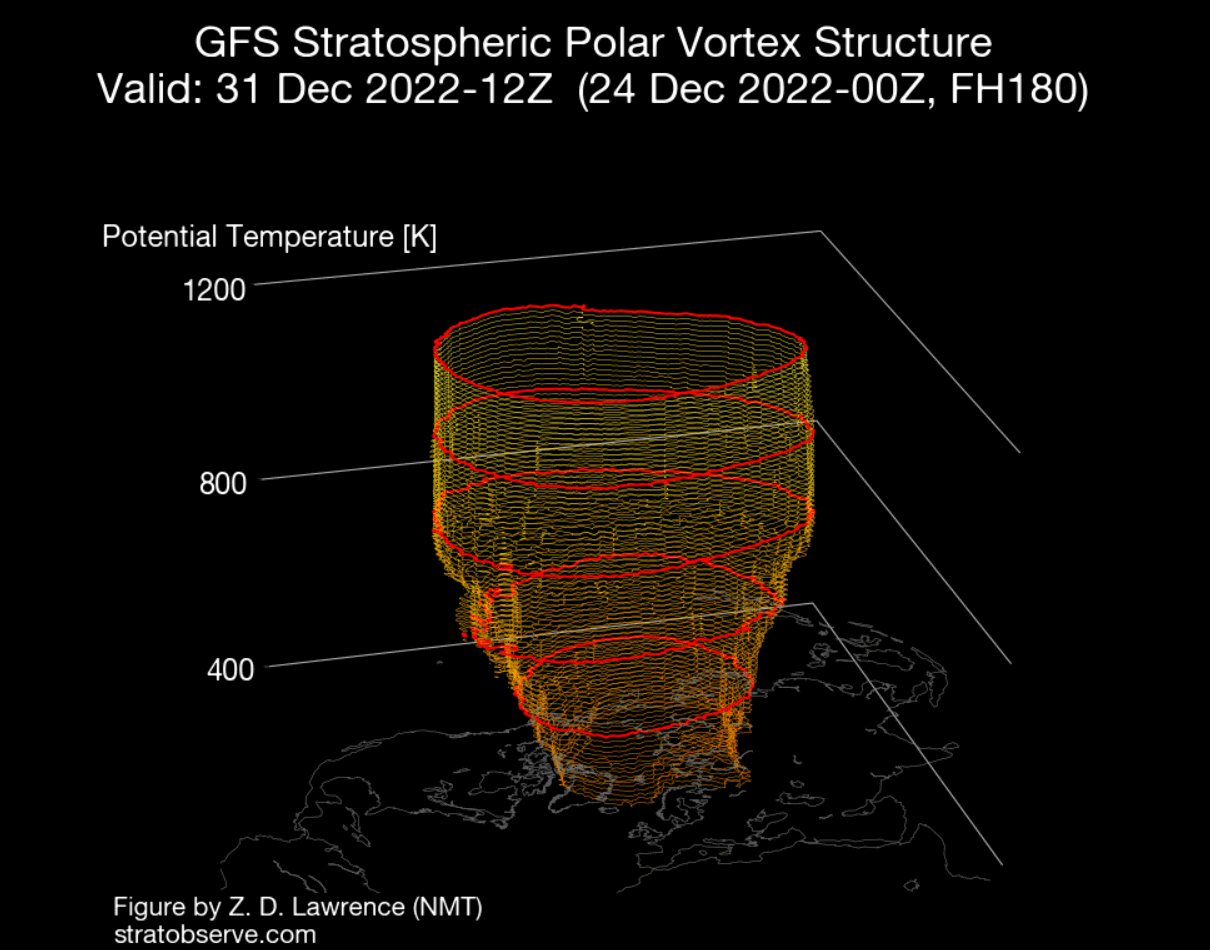
We produced a 3-dimensional image of the Polar Vortex, extending from the lower levels into the Stratosphere. The vertical axis is greatly enhanced for better visual presentation. You can see what the actual structure of the Polar Vortex looks like.
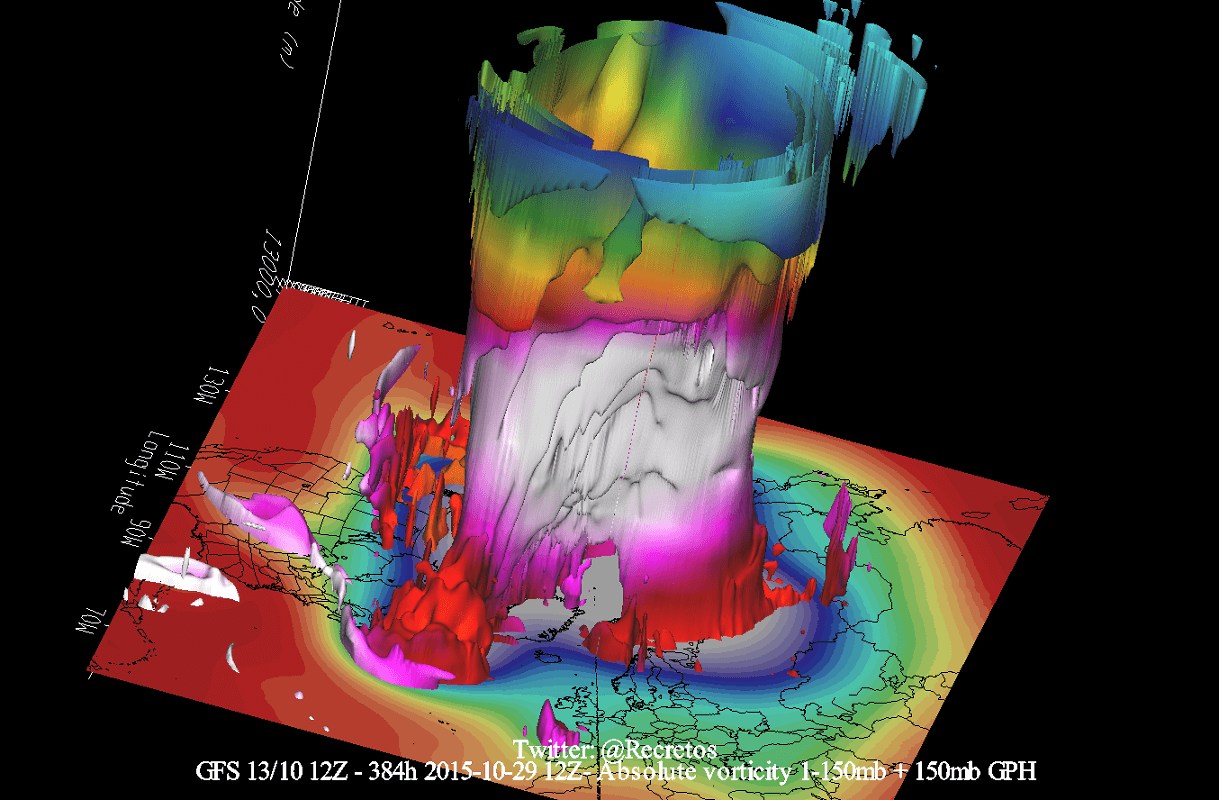
The upper (stratospheric) part is more circular and symmetrical as it spins higher above the ground. But the lower structure of the polar vortex is much more uneven and mainly disrupted. That is due to the influence of the terrain/mountains and strong pressure systems acting as obstacles in the flow.
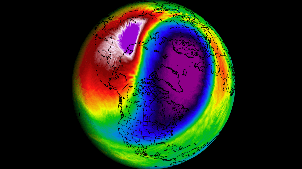
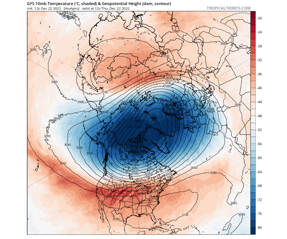
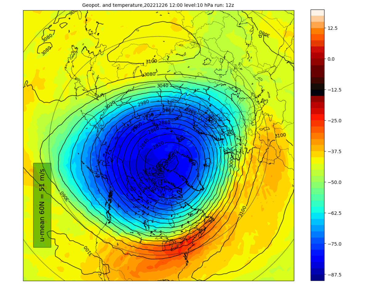
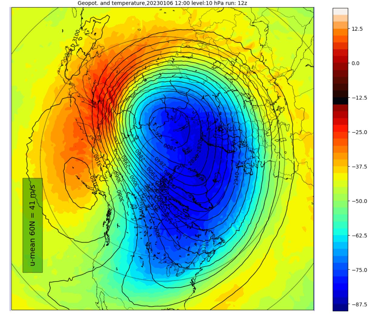
The image below shows the high-altitude Polar Vortex at around 30km/18.5miles in the middle Stratosphere during Winter. It is circular, with the temperature dropping quickly towards its inner core.
The stronger winds are typically found in the outer edge, also called “the surf zone”. Winds are of great importance when describing the polar vortex, as they are usually the first to show that something in the polar vortex is changing.
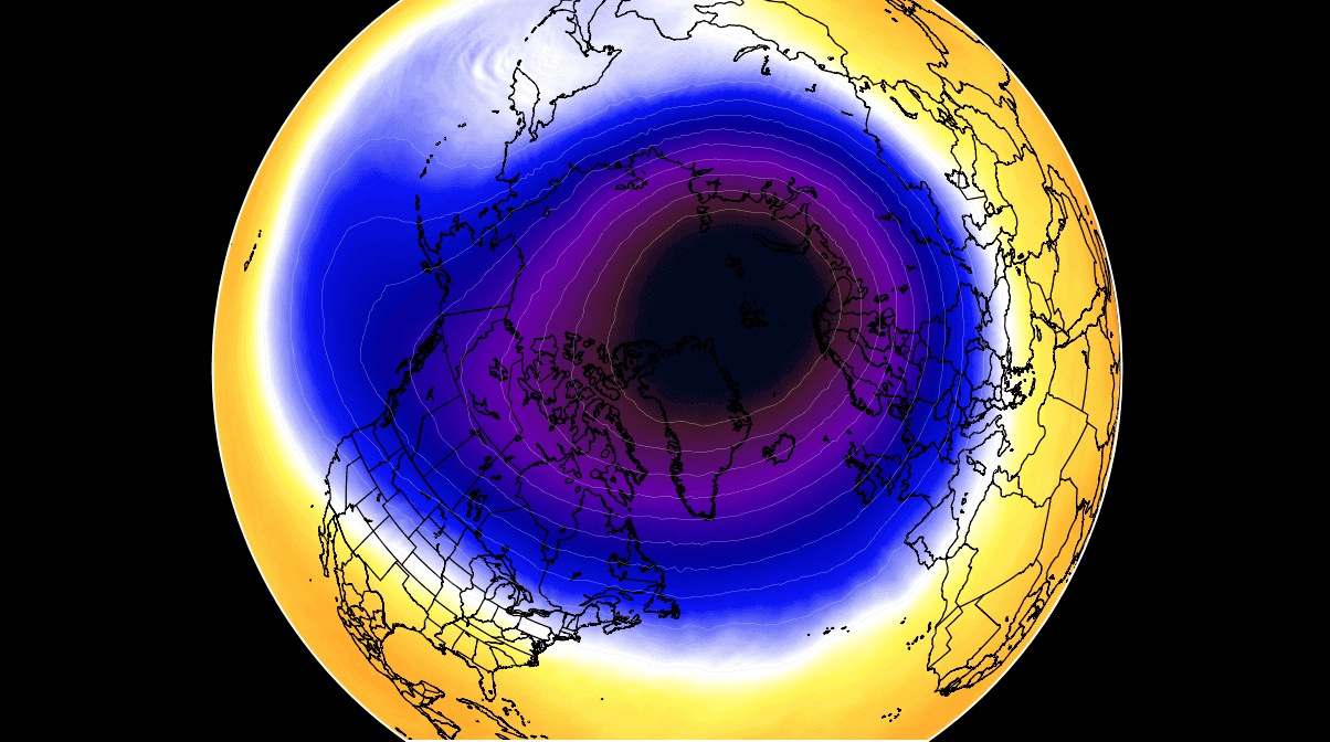
In the following image below, we have the lower layers of the polar vortex at around 5km/3miles. The closer to the ground we go, the more deformed the polar vortex gets. That is because it has to interact with the terrain and strong pressure systems.

Notice the cold “arms” extending colder air and snowfall into the lower latitudes. These arms pack a lot of energy and can create strong winter storms, like the latest artic outbreak across the United States.
So to recap, the Polar Vortex behaves like a very large cyclone, covering the whole north pole down to the mid-latitudes. It is connected through all atmospheric levels, from the ground up, but can have different shapes at different altitudes.
We monitor any Polar Vortex activity because it can have weather implications across the entire Northern Hemisphere. And that is regardless if it is weak or strong.
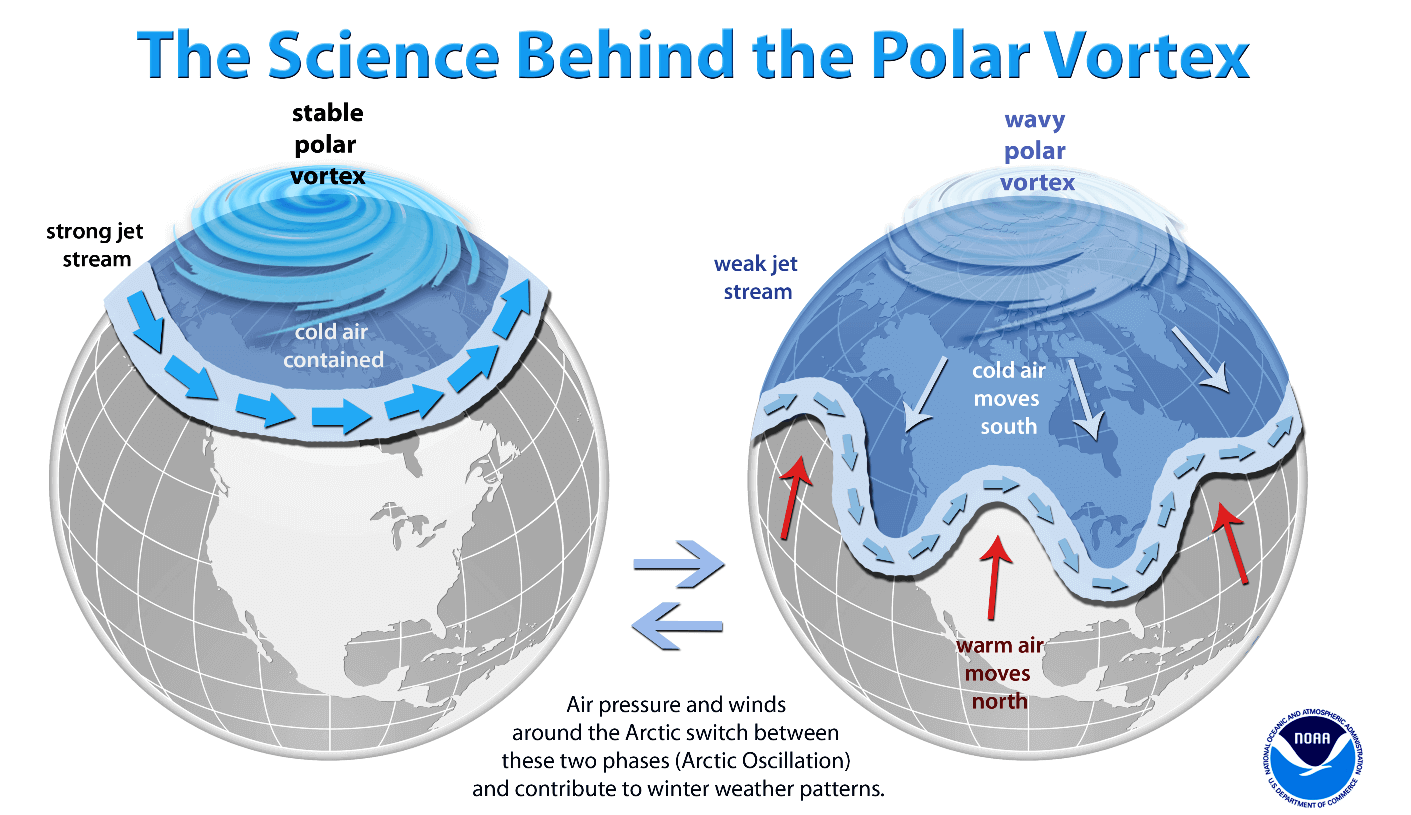
A strong Polar Vortex usually means strong polar circulation. This locks the colder air into the Arctic circle, creating milder conditions for most of the United States and Europe.
In contrast, a weak Polar Vortex creates a weak jet stream pattern. As a result, it has a harder time containing the cold air, which can now escape from the polar regions into the United States and Europe. Image by NOAA.
To put the Polar Vortex into perspective, we produced a high-resolution video below, showing the vortex spinning over the Northern Hemisphere in the Stratosphere at the 30mb level, around 23km/14miles altitude.
The video mainly shows that the Polar Vortex is not just one winter storm or a cold outbreak that moves from the Midwest into the northeastern United States.
It is a large cyclonic area spinning over the entire Northern Hemisphere, from the ground up to the top of the Stratosphere and beyond, reaching over 50km/31miles in altitude.
POLAR VORTEX AND WINTER START
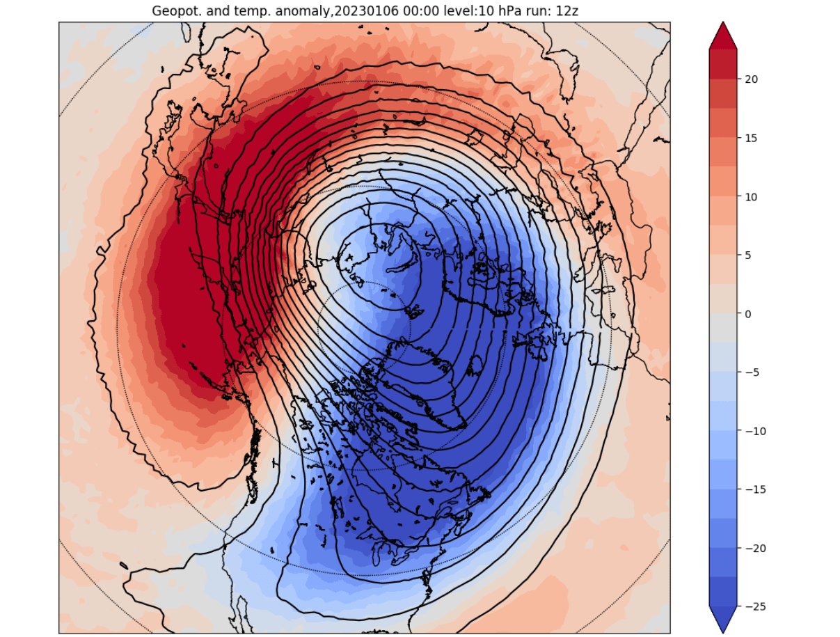
Winter 2022/2023 began in a very interesting way when it comes to the Polar Vortex. The image below shows the pressure anomalies from the ground up into the upper Stratosphere. There are strong high-pressure anomalies in the lower levels and low-pressure anomalies in the Stratosphere above.
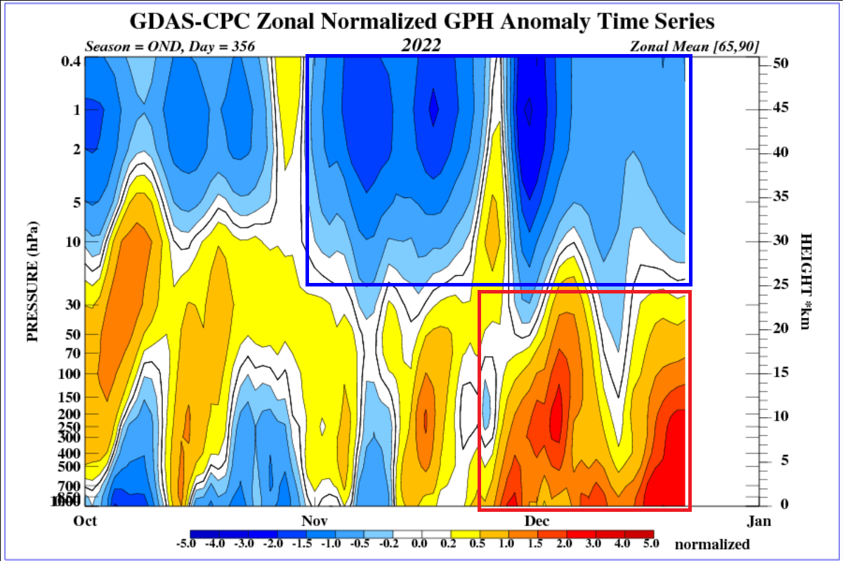
This shows a significant disconnect between the lower and upper polar circulation. While the stratospheric polar vortex remained strong, the lower levels were heavily disrupted.
You can see this disrupted pattern in the pressure analysis below. Strong high-pressure systems dominated the polar circulation. That enabled a release of cold Arctic air down into the United States.

You can see these cold anomalies in the temperature analysis below. Again, Arctic cold spilled down into the United States, while strong warm anomalies pushed into the polar regions.
But, at the same time, the stratospheric polar vortex retained its composure. It had a healthy cold core and a good shape. However, it failed to push its influence downwards towards the surface, as the high-pressure systems were too strong. But that is soon to change.
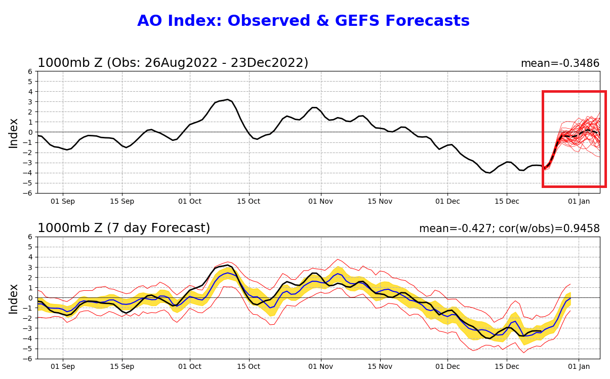
Below we have the Arctic Oscillation (AO) index. It simply tells us how strong or disrupted polar circulation is. You can see strong negative values, indicating a disrupted pattern and cold weather. But the ensemble forecast shows a return to neutral values, indicating a weather pattern change.
FROM THE STRATOSPHERE TO THE SURFACE
The stratospheric Polar Vortex is expected to intensify rapidly in the coming days. You can see it in the image below. It will have a very circular shape, a broad cold core, and a healthy wind field.
If we look at the 3D structure, we can see the Polar Vortex in all its glory. We see the nice and stable vertical structure connected to the lower levels. This is an almost perfect example of a stable winter Polar Vortex.
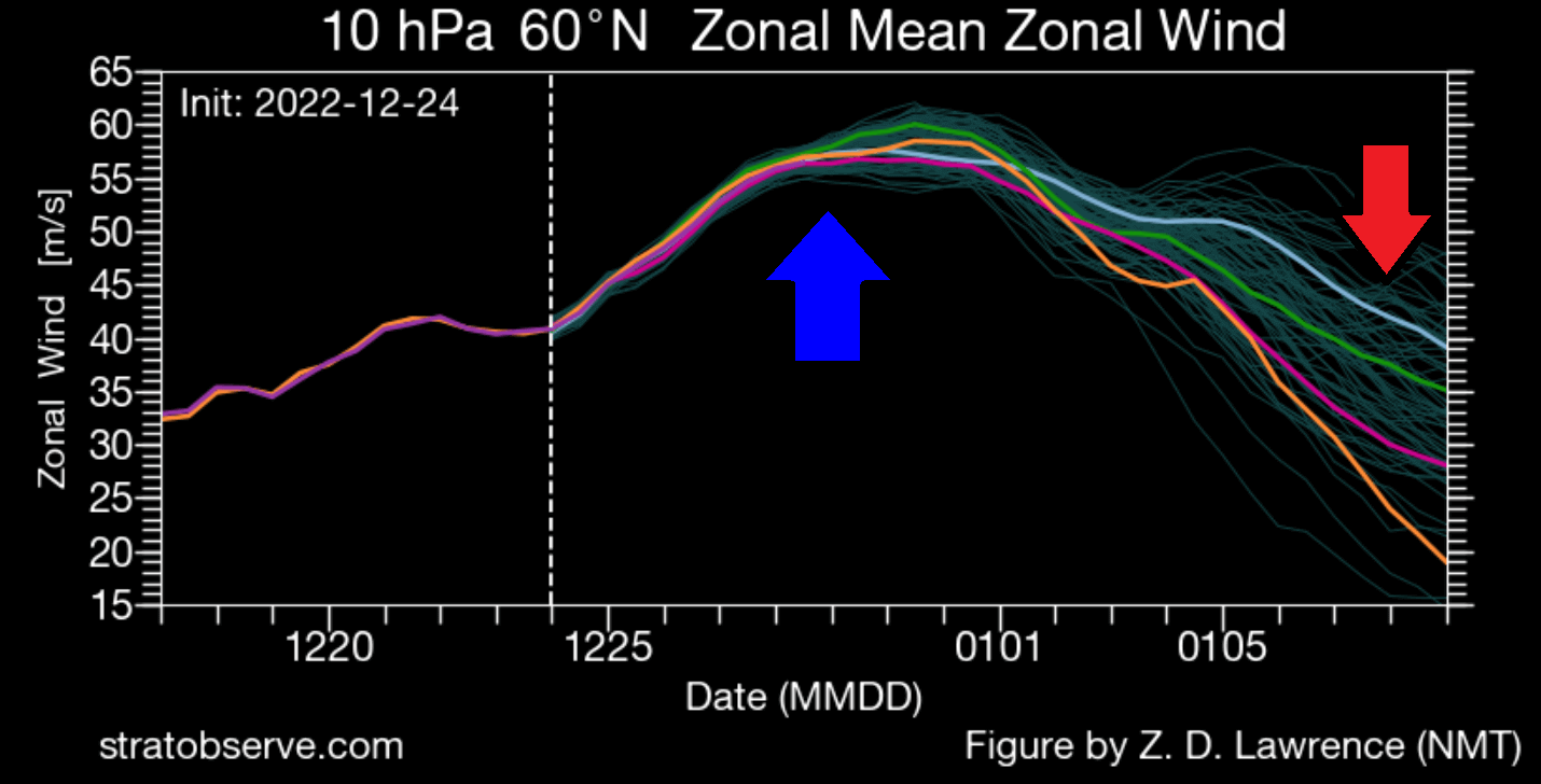
The wind forecast in the image below also shows the increase in power. We see wind speeds increasing around the stratospheric Polar Vortex, which in most cases indicates a power-up. But note a decrease in the later stages. We will touch on that soon.
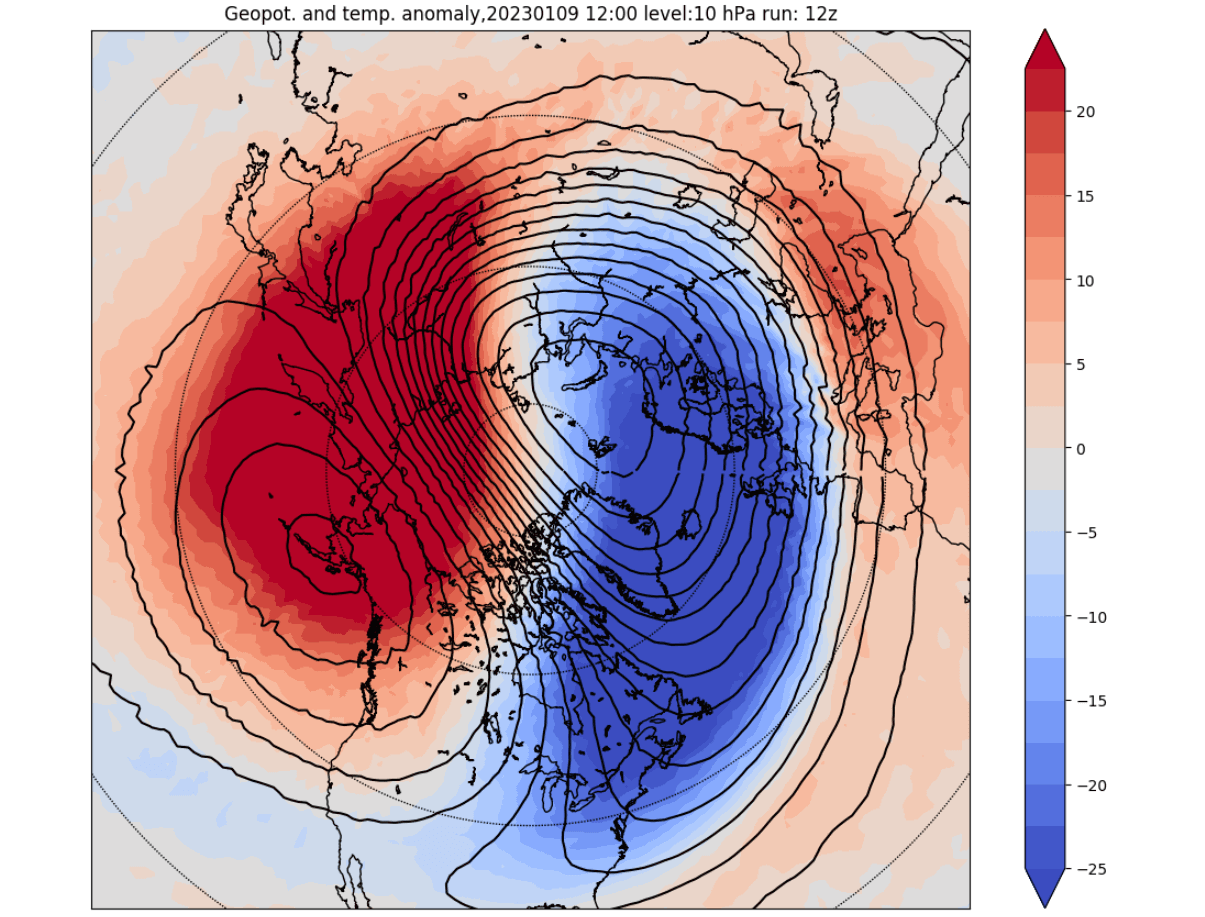
The best way to track the influence of the stratospheric Polar Vortex is by looking at the pressure anomalies. You can see the vertical pressure anomalies in the image below. The red square shows the outgoing high-pressure anomalies. But note the strong low pressure (blue) coming down from the Stratosphere.
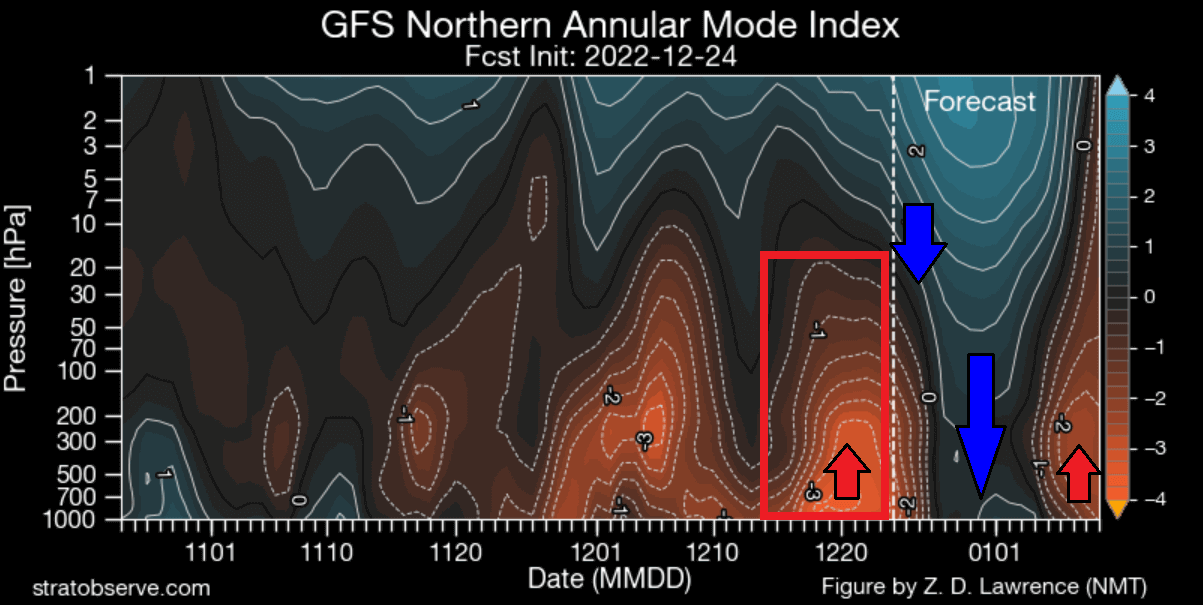
This low-pressure anomaly is the strong Polar Vortex connecting to lower levels. We can trace that by observing the pressure changes in the lower altitude, usually by low-pressure areas appearing over or around the polar regions.
Looking below is the pressure pattern forecast for next week. You can see these low-pressure areas taking over the polar regions. There is an extension into the western United States and the North Atlantic. This will initiate a weather change across North America, driving unseasonably warm weather to replace the cold air.

WEATHER PATTERN CHANGE
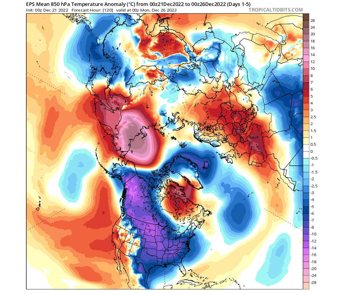
The low-pressure area over the western United States enables a strong southerly flow over the central and eastern United States. The southerly flow is usually warm and can cause unseasonably warm weather if strong enough.
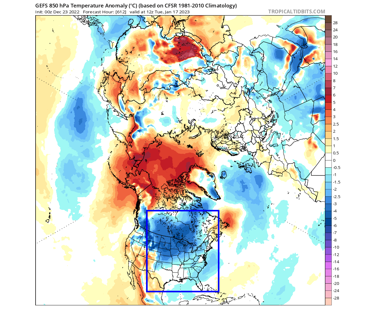
If you look at the temperature forecast below, you can see significant warm anomalies over much of the central and eastern United States. That is due to the strong southerly flow, extending warm anomalies all the way up into Canada.
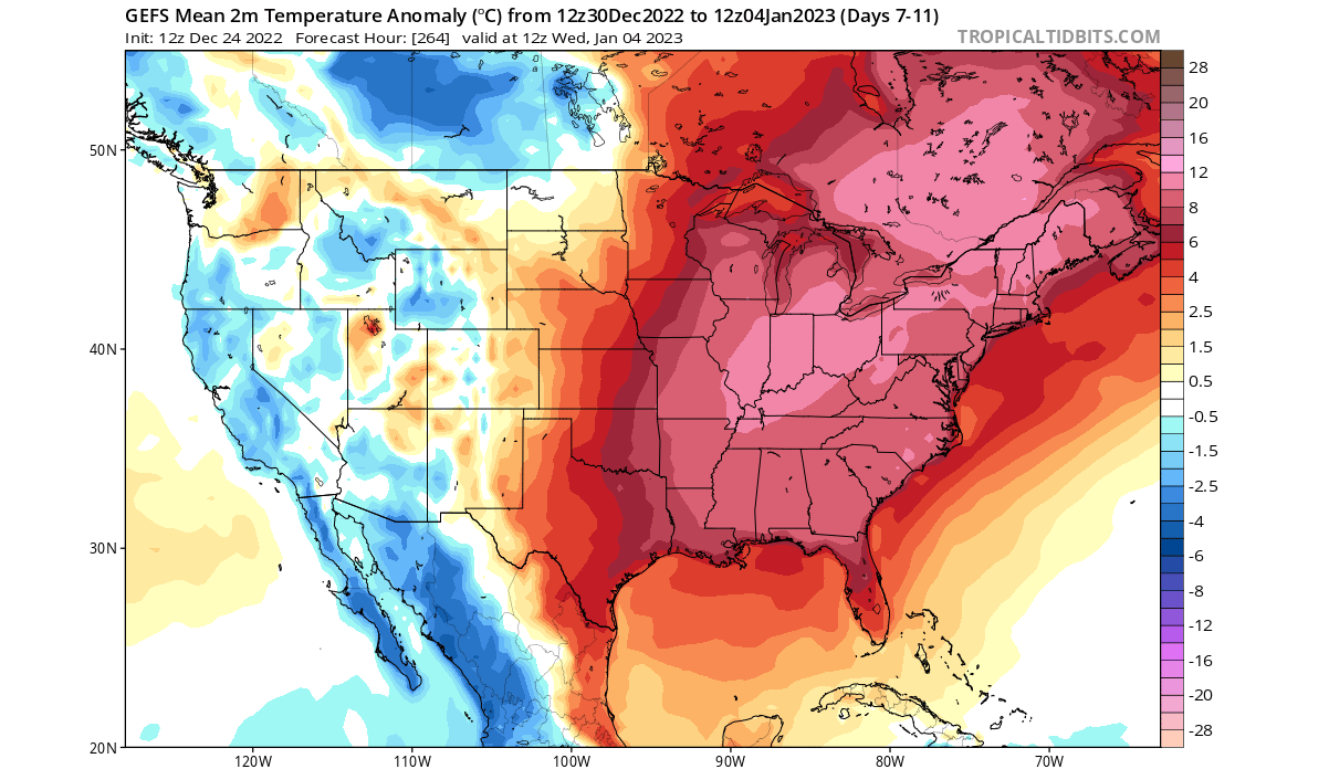
Looking at the official 6-10 day temperature forecast by NOAA, you can also see a significant warm anomaly over the eastern United States. This will be quite an unseasonable event for Winter, even more so as it will follow the current record cold outbreak.

With westerly and southerly winds, there is also a lot of moisture. And the NOAA’s official 6-10 day precipitation forecast shows more precipitation than normal over much of the United States.

The pattern change also brings low pressure into the North Atlantic, enabling a warm pattern over Europe. High pressure and westerly winds will enable warmer weather over much of the continent.

But as mentioned in an earlier graphic, a new disruption is starting to appear in the forecast.
STRATOSPHERIC POLAR VORTEX DISRUPTION WAVE
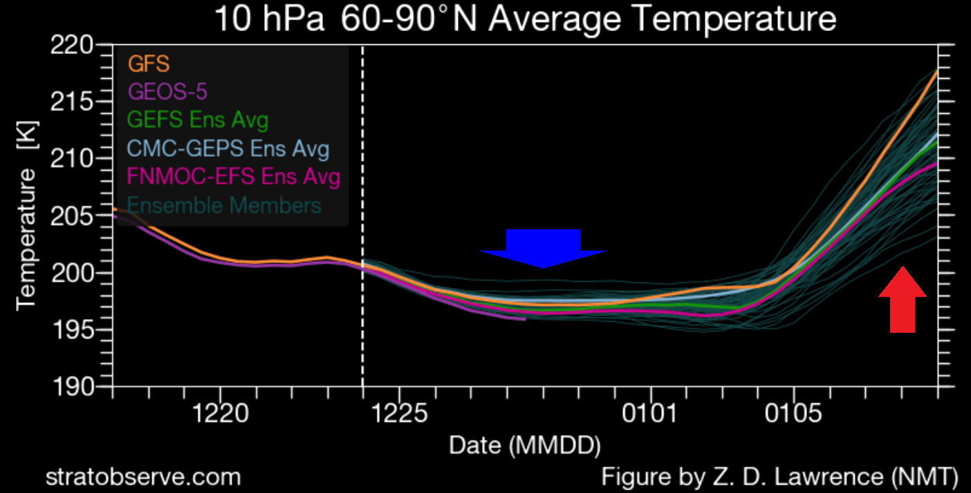
Looking at the ensemble graphic again, we have the stratospheric temperature forecast at the 10mb level (30km/18.5miles). Again, you can see the cooling of the polar vortex as it intensifies in the following days. But a rapid temperature rise is forecast, as a warming wave will begin.
But where does this warming wave suddenly come from? Usually, it is from the direct influence of strong pressure systems, having an impact upwards into the Stratosphere. Pairs of pressure systems are also known as Rossby Waves.
Strong Rossby Waves systems deflect energy upwards into the Stratosphere. That energy can deform the polar vortex, temporarily pausing its strengthening or weakening its circulation.
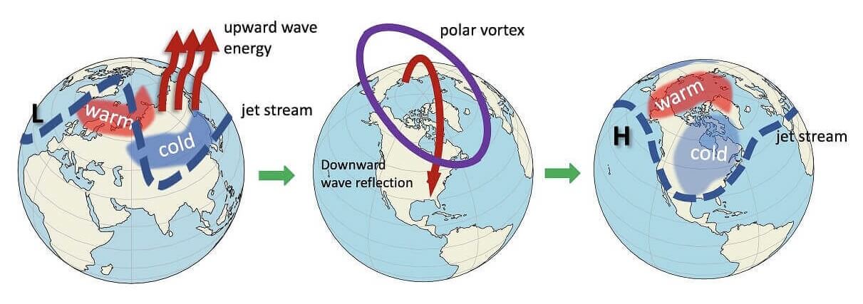
In the image below, you can see the vertical wave activity example. First, the energy goes upwards into the Stratosphere, which impacts the polar vortex, which then affects the polar circulation back down, changing the weather patterns.
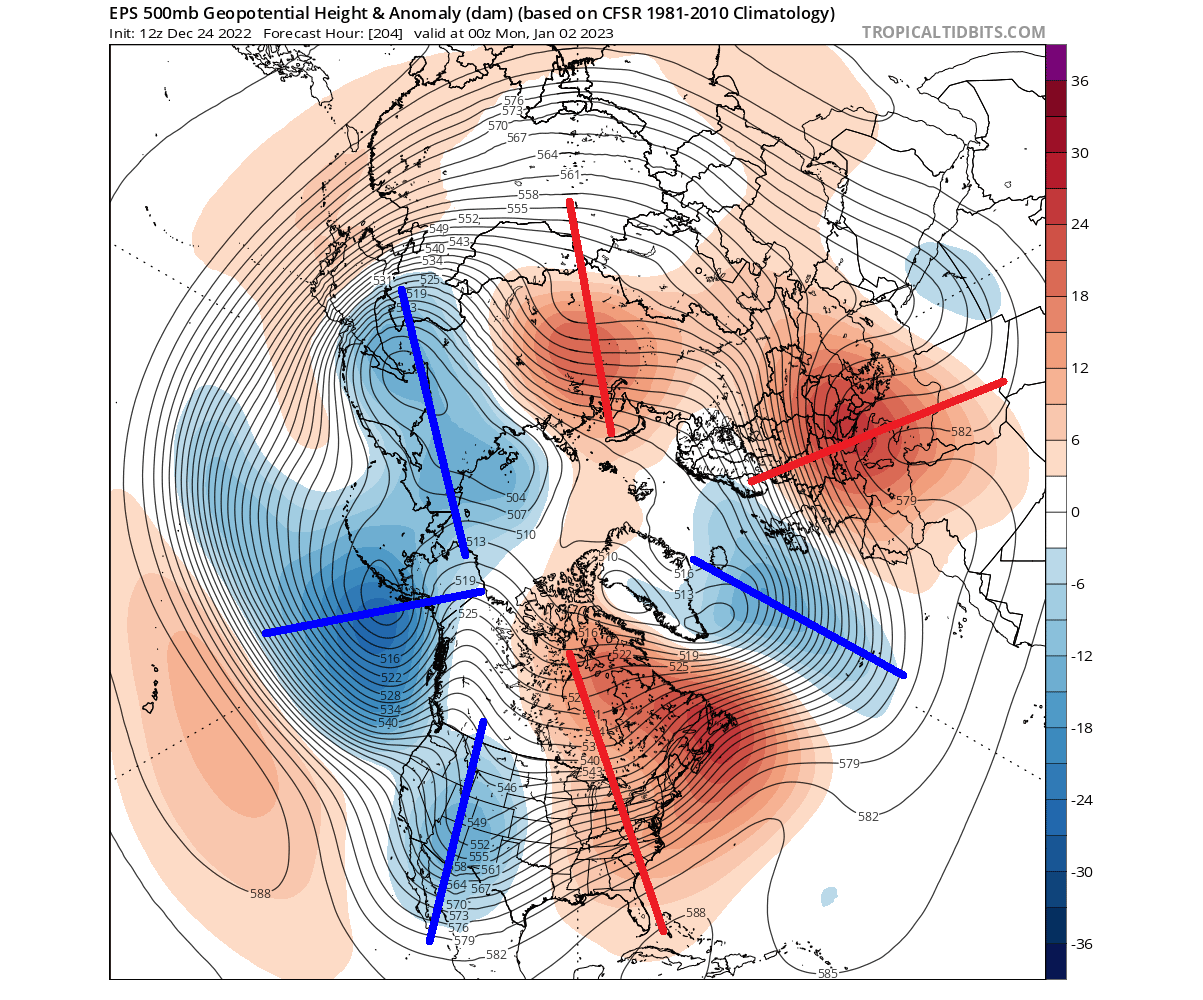
We can see the Rossby waves in the pressure forecast below. Notice the pairings of high and low-pressure regions. This setup enables the “wave breaking”, sending energy upwards into the Stratosphere and disrupting the Polar Vortex dynamics.
We can see the first signs of an emerging stratospheric warming wave in around ten days. A high-pressure region will emerge in the North Pacific in the Stratosphere. It will start deforming the Polar Vortex, creating a more oval shape.
At the same time, a warming wave will start emerging over eastern Siberia. You can see it better in the temperature anomaly below for the middle Stratosphere. This is the first step in the chain of events that can substantially impact weather patterns down the line.
The extended ensemble forecast from the ECMWF shows this warming wave in the wind speed forecast. You can see it below, showing the before-mentioned intensification and the power drop as the warming wave starts.

But what comes after this warming wave is not certain. The extended ECMWF is notorious for showing a stronger Polar Vortex. So it could be underestimating the aftermath of the warming wave and potentially more serious disruption.
STRATOSPHERIC WARMING INTENSIFIES
Vertical energy transport is forecast to be strong. We can track it in the special graphic that shows its vertical motion. Marked on the image below, you can see the vertical energy (heat) transport into the Stratosphere. It drives the temperature wave and the Polar Vortex disruption.

The forecast below shows the stratospheric high-pressure area over the North Pacific getting stronger. At the same time, the temperature wave is also intensifying. As a result, the Polar Vortex is even more “compressed” or displaced, along with its cold core.

You can see that even better if we look at the anomalies at this level for the same forecast period. Below is the pressure anomaly, which reveals the growing impact of the stratospheric high-pressure area over the North Pacific.

Below is the temperature anomaly forecast, which shows a substantial temperature departure from normal. This is a good start to potentially evolve into a proper Polar Vortex collapse event. But the forecast data is not there yet, and we first need to get this warming event into a closer range.
Looking at the extended ensemble forecast for mid-January, we can see a disrupted lower-level pattern again. You can see a high-pressure anomaly over the polar regions and the low-pressure areas into lower latitudes.
This would enable another cold air outbreak over the United States, as seen in the temperature forecast below. Such patterns are common after strong Polar Vortex disruptions. And as the extended ensembles show such a development, it is likely connected to the stratospheric dynamics. Especially since we see the stratospheric warming wave developing in the same forecast.
But there is a difference between small warming waves and a proper collapse of the Polar Vortex.
MID-WINTER POLAR VORTEX COLLAPSE
A proper Polar Vortex collapse event (Sudden Stratospheric Warming) basically means a strong temperature and pressure rise in the Stratosphere and a resulting collapse of the Polar Vortex circulation.
For a disruption event to be classified as a Sudden Stratospheric Warming event or a full collapse, there is one major condition. The stratospheric winds, which are mostly westerly in Winter, must be reversed to easterly.
One such major event was recorded two winters back. Below you can see the temperature in the mid-stratosphere as the Sudden Stratospheric Warming event was in progress. The temperature wave fully spread over the North Pole, splitting the Polar Vortex and breaking its circulation.

But what does such an event mean for our everyday weather at the surface? Well, you have to understand that it takes some time for the effects from the Stratosphere to reach the lower levels. That is why we usually look at the 0-30 day periods after such an event to identify the weather changes.
The average temperature of 0-30 days after a Polar Vortex collapse event shows that most of the United States are typically colder than normal, along with Europe. Note: this is an average picture of many SSW events. Each stratospheric warming event is different and does not automatically mean a strong winter pattern.
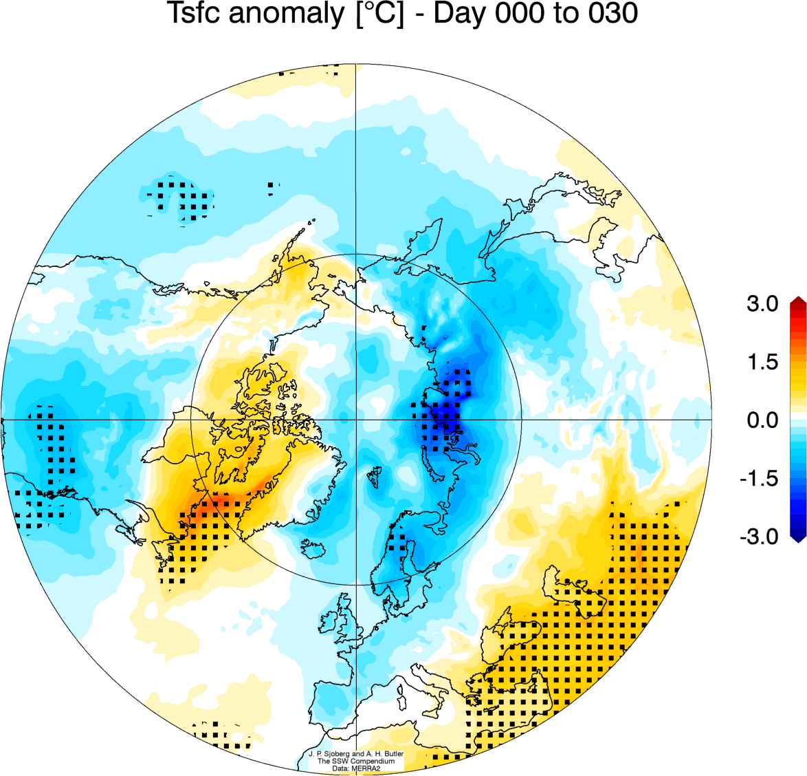
Looking at the snowfall below, we can see above-average snowfall over much of the eastern United States and Europe. Again, this is an expected response, as typically, after major stratospheric warming, the colder air has an easier path towards the south and into these regions.

So as you can see, having a strong or weak Polar Vortex can significantly change Winter weather in the United States, Canada, and Europe. For this reason, we closely monitor the weather patterns and all activity surrounding the Polar Vortex.
We will keep you updated on the global weather pattern development for the coming seasons, so make sure to bookmark our page. Also, if you have seen this article in the Google App (Discover) feed, click the like button (♥) there to see more of our forecasts and our latest articles on weather and nature in general.
Don’t miss:
Significant warm relief is forecast after Christmas over the United States and Canada