More than 200 million were under the effect of a historic Arctic blast and winter storm Elliot, gradually departing Northeast U.S. A record-breaking cold, frigid windchill, blizzard, and deep lake-effect snow blanket for Buffalo are soon over. And in just a matter of a few days, North America’s weather pattern will dramatically flip into much higher temperatures in the final days before New Year’s Day 2023. Thanks to a southern lobe of the Polar Vortex aloft moving east.
This Christmas weekend holidays are the coldest in 20-30 years for millions across Canada and the United States. What started as an unpreceded 30+ degrees rapid temperature drop along the High Plains in Wyoming and Colorado on Thursday has led to a widespread deep freeze rapidly moving across the Lower 48. Reaching Gulf Coast and Northeast U.S. within 24 to 36 hours from its beginning.
Winter Storm Elliot then had an explosive development over the Great Lakes; a so-called bomb cyclone formed and was battering the southern and eastern shores of the lakes. Abundant and heavy snow combined with extreme winds, gusting 60-80 mph around Buffalo, NY. This weekend, hundreds were stranded in deep snow, drifts, and blizzard conditions.
Soon after Christmas, a significant change will follow, with temperatures fast recovering from west to east across the nation. This Saturday, dramatic warming has already been observed along the Rocky Mountains from southern Alberta to New Mexico. Temperatures are 40-50 °F warmer than they were just 24 hours ago, on Friday.

After the historic arctic front spread the cold across more than two-thirds of the country, warming up is already underway across the central parts of the U.S. The front is leaving Florida and East Coast into the open Atlantic, ac bomb cyclone is forecast to reach its peak over eastern Canada for Christmas Day.
The final week of 2022 will dramatically increase temperatures across most of the U.S. and southern Canada. Temperatures are forecast to climb very high, being well above the average. Most days next week will be around 20-30 °F warmer than usual. Especially across the eastern two-thirds of the U.S. and Canada, lasting into the New Year 2023.
The video animation forecast below reveals this rapid change of temperatures across North America as the Arctic front exits the continent to the east on Christmas Day. Warmer air will wash away most of the continent’s bitterly cold air. Forecast to become extremely anomalous right around the New Year, especially across the east-central United States and Canada.
An outstanding temperature flip is forecast, with air mass to become nearly 30-40 °F above the average for the Upper Midwest, Great Lakes, Ohio Valley, Northeast U.S., Quebec, and Ontario, Canada. Can one imagine how extreme this pattern flip is since we are going from 40 degrees below average to 30-40 degrees F warmer than usual in just a few days? 2022 is finishing with a bang, from one extreme to another.
All these intense and rapid weather changes are the results of the Polar Vortex circulation aloft, being particularly powerful as the Winter season of 2022 officially starts. Through mid-December, its coldest parts, known as the southern lobe, were parked above Arctic Canada. It releases the Arctic Blast towards the south, and now, as it shifts towards eastern Canada and Greenland, it will flip the weather pattern across North America.
We must understand that the Polar Vortex feature plays an important role during winter. Very often, it sends deep upper troughs with major cold outbreaks, resulting in extreme winter weather and snowstorms across the North American and European continents.
Let’s look at some details to understand its effects on our weather better before we dig into the upcoming pattern change.
WHAT IS THE POLAR VORTEX, AND HOW DOES IT AFFECT OUR WEATHER?
Earth’s atmosphere has several layers that are rounding our planet. Most of our planet’s weather dynamics occur in the lowest two layers. These are the troposphere and the stratosphere immediately above it.
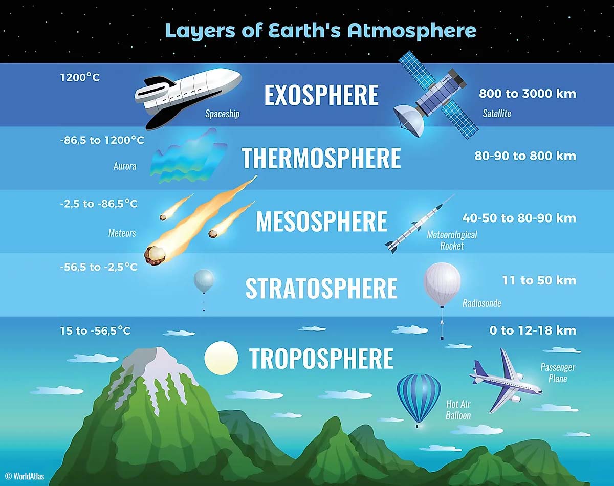
The troposphere layer is the lowest one, where all the weather changes we experience take place. The troposphere layer extends from the Earth’s surface (sea surface) into the sky. The troposphere’s depth varies greatly, from 8 km to nearly 20 km, depending on where you live. It is deepest above the equator but gets much thicker above both poles.
Above this layer is a much deeper layer known as the stratosphere. A stratosphere layer is about 11-50 km thick and very dry. We also find the Ozone layer in it, which is vital in protecting our planet.
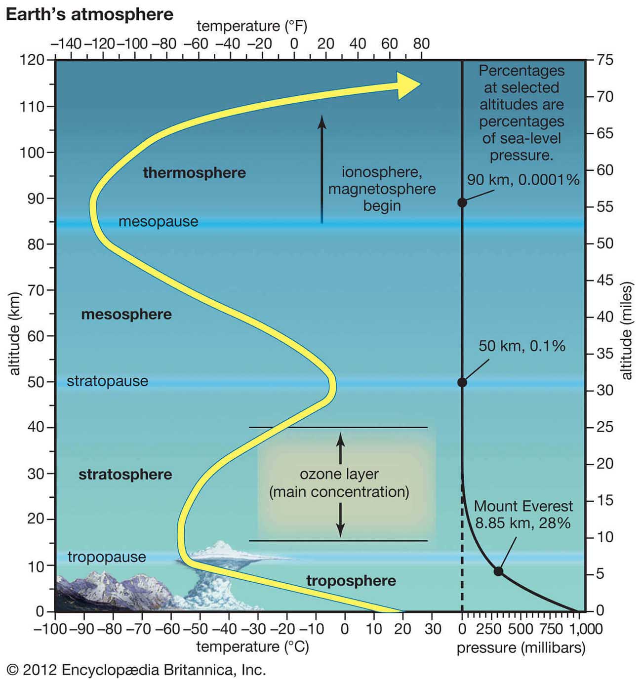
Generally, weather behavior has one vital feature in the stratosphere for all its dynamics. It is the Polar Vortex. The Polar Vortex is an enormous, three-dimensional ring of violent winds, blowing 150-200 mph, located about 20-50 km above the Earth’s surface. Earth has two vortices, one surrounds the North, and the other is above the South pole. The intensity of the Polar Vortex is the strongest during winter.
Therefore, the troposphere and the stratosphere layers are crucial for Earth’s climate because the Polar Vortex covers most of the bottom half of the atmosphere. Starting from the Earth’s troposphere and extending up into the stratosphere. So it has an important role in the winter weather dynamics across the high and mid-latitudes.
Despite the vortex spinning high above our troposphere, it is still directly connected to the lowest part of the atmosphere where we live. The Polar Vortex shapes our daily weather in many ways. As it works as one sizeable hemispheric circulation.
FORMATION OF THE POLAR VORTEX
So, the Polar Vortex generally has seasonal differences. It is the strongest during the winter, as we learned. During the autumn months, the polar regions receive much less sunlight over time due to the inclination of the Earth’s axis, which sends the North Pole into a position where the cooling begins faster.
While the Polar regions are getting cooler with time, the atmosphere further south towards the equator remains quite warm. Those layers receive much more sunlight and energy from the Sun than the polar regions. Thus, the weather is warmer.

As the temperatures fall over the polar regions, they also lower the ambient surface pressure. And a similar process occurs in the stratosphere layer above as well. Therefore, the temperature difference between the North pole and the equatorial region significantly increases. Forming a large low-pressure (cyclonic) circulation across the polar stratosphere.
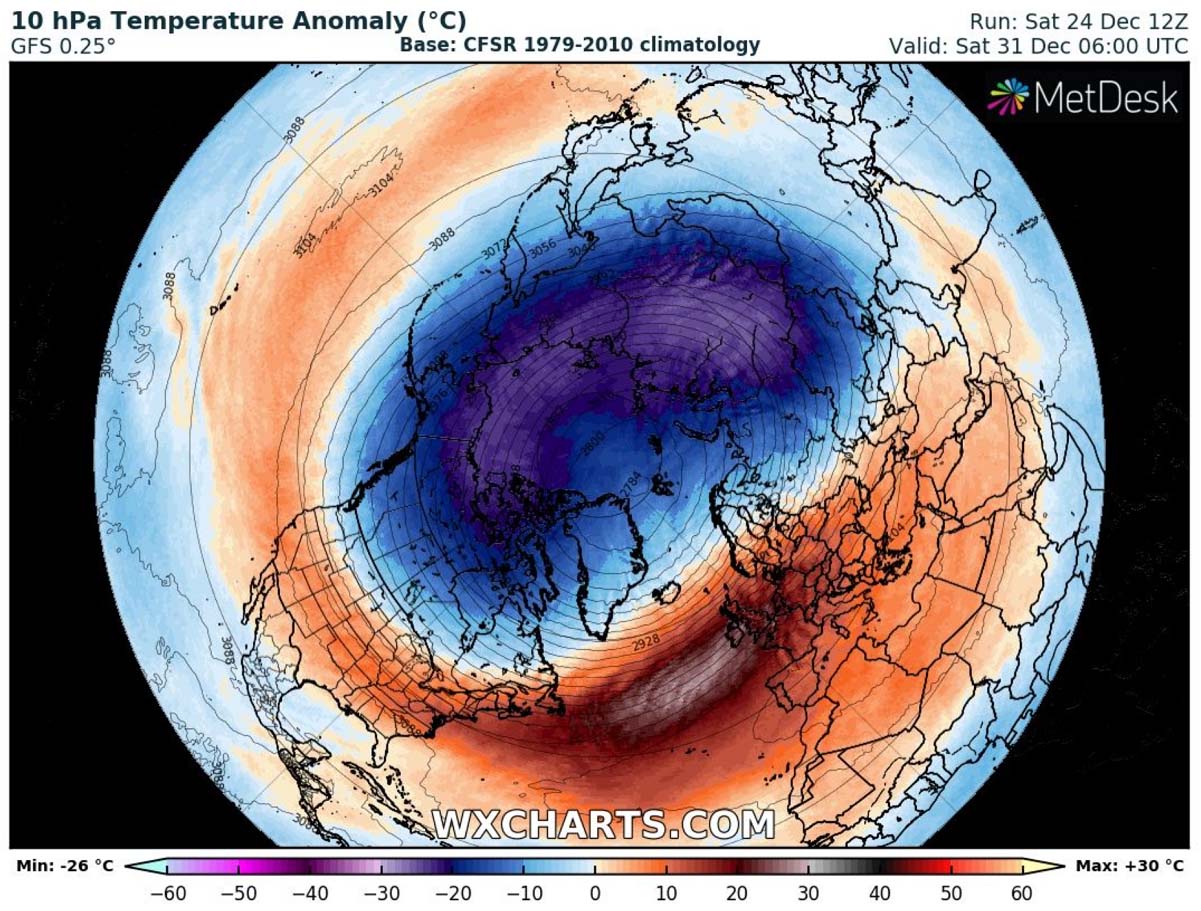
The above chart represents a typical example of the Polar Vortex, which is set at around 30 km (18 miles) altitude during the winter. It shows the powerful jet stream winds rounding the vortex core inside. So, when discussing the Polar Vortex’s behavior, we usually look at 10 mbar level charts.

Knowing these details, we can conclude that the Polar Vortex is a very large cyclone. It covers the whole north pole region. With the wavy dynamics of the jet stream and the Polar front, the vortex occasionally develops strong lobes.
These lobes then turn south, towards the mid-latitudes, since the polar front is a very dynamic feature due to the high contrast of pressure and temperature. The Polar lobes’ intensity strongly depends on the intensity of the vortex itself.
COLD PATTERN FLIPS INTO MUCH WARMER FOR NORTH AMERICA
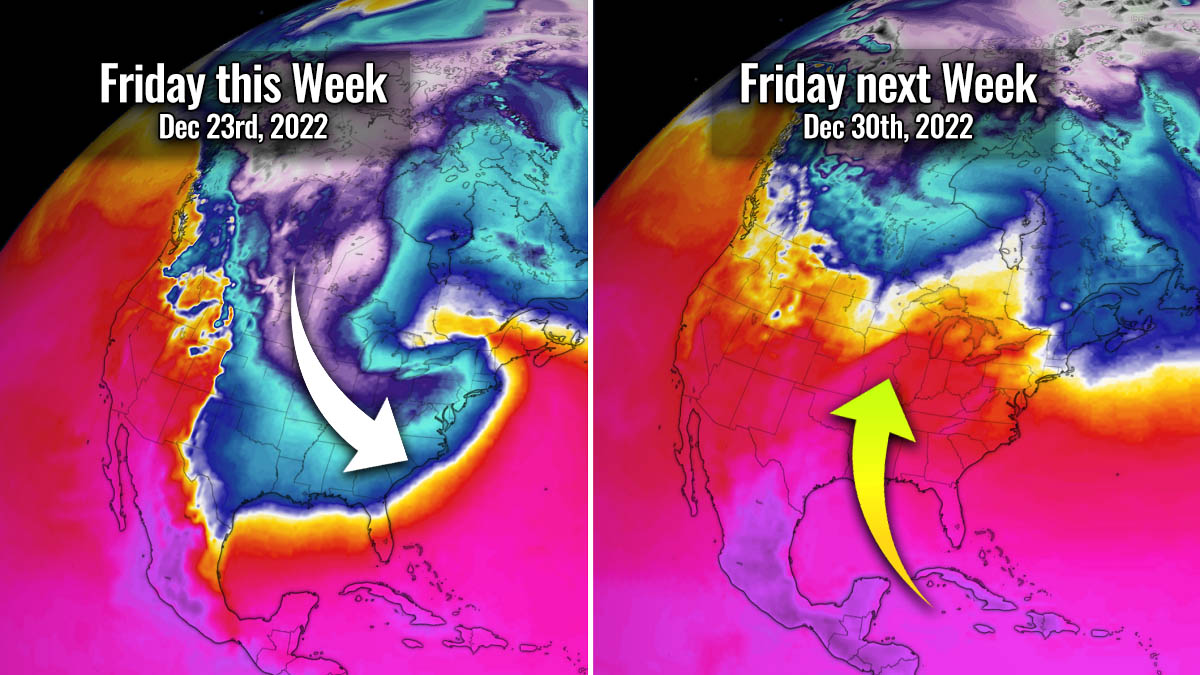
The ongoing weather pattern across North America will dramatically flip in just a few days this last week of 2022. Form a well-pronounced dipole weather pattern beneath the front edge of the Polar Vortex lobe aloft; the deep Low over the eastern half will be replaced by a strong High. While on the west, deep troughs develop and spreads south across the West Coast.
So, as we experienced, the High on the west and Low on the east mean Arctic air plunges south, and the flipped weather pattern means the opposite. After Christmas, air masses will arrive from the south and southwest of the much warmer sub-tropical region. The 500 mbar chart below represents a weather change from Saturday before Christmas Day against Thursday next week, Dec 30th.

When an upper High takes place, it also brings more stable weather and much warmer days. As the final week of 2022 advances, Arctic cold and deep freeze will vanish shortly after Christmas. The high contrast of pressure will follow, flipped from the Christmas weekend.
With the decaying Arctic blast, the associated high-pressure system is also dragged into the eastern parts of the U.S. and Canada. In contrast, pressure lowers under the upper trough farther west. By judging the isobars (lines connecting equal pressure), we can understand that air mass will be advecting from the south.

Indeed, the strong pressure difference pumps warmer air from the south that will extend for days. And gradually spread across more than two-thirds of the continent before the New Year. The air mass will get warmer daily and reach its most anomalous period around New Year.
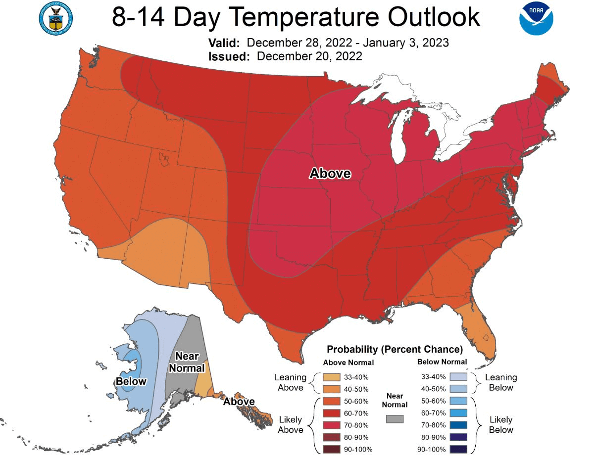
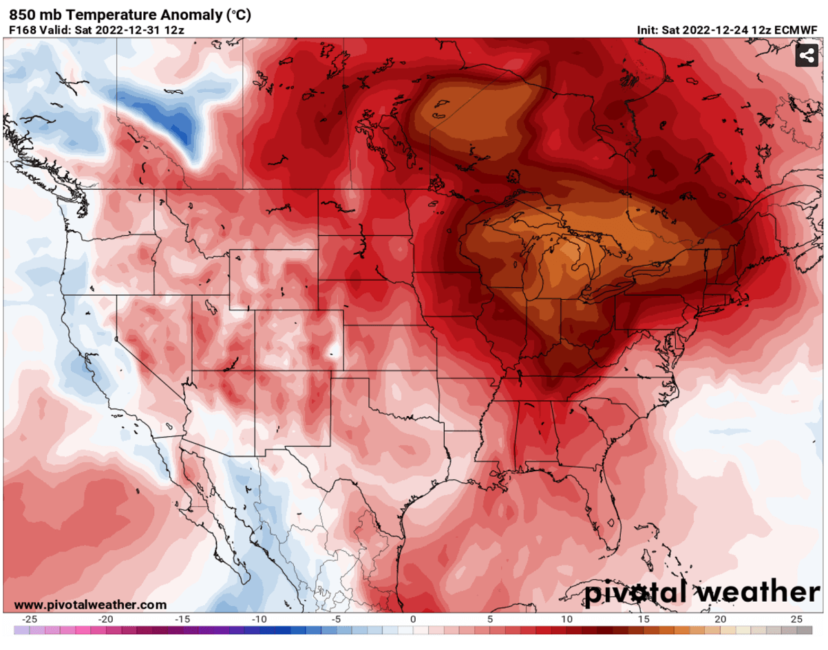
The attached chart below represents the 850 mbar temperature across southern Canada and the U.S. for Saturday, Dec 31st. Only a minor part of the continent is near-normal values, while a large part of the eastern U.S. and Canada will see extremely warmer weather than average. 15-20 °C above normal for this time.
This is an extreme pattern change in just a couple of days if we look out of the window and experience the ongoing cold weather. By Wednesday, temperatures will finally release the cold from the remainder of the east and southeast portions of the U.S.
While the warmth takes a higher gear across the west and central parts. 20 to 30 degrees F warmer than average temperatures will spread across all the states on the western two-thirds of the country. Being the most significant from New Mexico and west Texas to Colorado, Wyoming to Nebraska, and South Dakota.

During the second half of the week, as we approach the New Year, temperatures are forecast to climb much higher, spread north and east across the country. Placed under the strengthening dome of stable blocking High aloft, significantly warmer weather is forecast for the next holiday weekend.
Daytime temperatures on Saturday and New Year’s Day will be particularly warmer from the low/mid-Mississippi Valley into the Upper Midwest and Ohio Valley and farther to East Coast, around 25 to nearly 40 °F above the average. The most intense temperature anomaly will be over the Mid-Atlantic, the Great Lakes, Quebec, and Ontario on Jan 1st. The warmth will also extend into the first week of 2023.

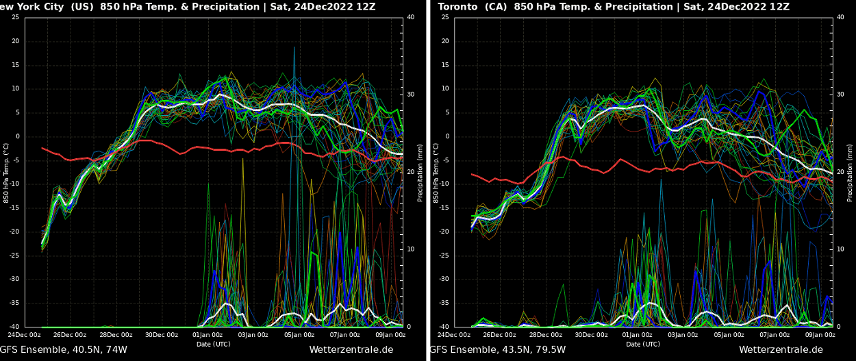
How extremely anomalous is the air mass with the upcoming weather pattern flip is best to represent with the Meteogram graf for the next 14 days. Attached below is the chart for New York City and Toronto, Canada. Both charts indicate extreme warming will take place soon after Christmas.
The left chart for New York City shows a warm-up from nearly -25 °C in the lowest levels on Christmas Day to nearly 10 °C by Friday, Dec 30th. That is a nearly 35 °C change in just a couple of days. Toronto chart is revealing quite a similar warming as well, both going with steep trend every day.
Furthermore, the return of the much warmer weather and moisture from the Gulf of Mexico will also increase the chance for precipitation along the Gulf Coast and the Southeast United States. Potential will also increase for thunderstorms to develop along the frontal system from Friday through Sunday.
Our team wishes you All the best for the holidays and the New Year 2023. We will continue covering the most extreme weather events that have the potential to impact many across the continues around the planet.
Images used in this article were provided by Windy, Pivotalweather and Wxcharts.
See also: