The situation across Europe this week is supported by a dipole weather pattern, with low pressure over the Atlantic and western Europe and more stable weather farther east and south. Starting tonight, an Arctic cold blast will begin spreading from north to south into the UK and Ireland first, gradually overspreading the rest of western and also central Europe for the weekend. Temperatures will be significantly lower than normal, the coldest for this winter season so far.
A lot of snow is forecast for the Alps while flooding rain farther south as several frontal systems will cross the European continent. Potential is also increasing for some good amounts of snow across a large part of central and partly western Europe later next week.
What we will discuss in detail below is the development of a persistent and progressive weather pattern, with a huge pool of very cold air mass coming up for a large part of the European continent. This will result after a strong upper High sitting over the Arctic region, sending a major cold outbreak far toward the south.
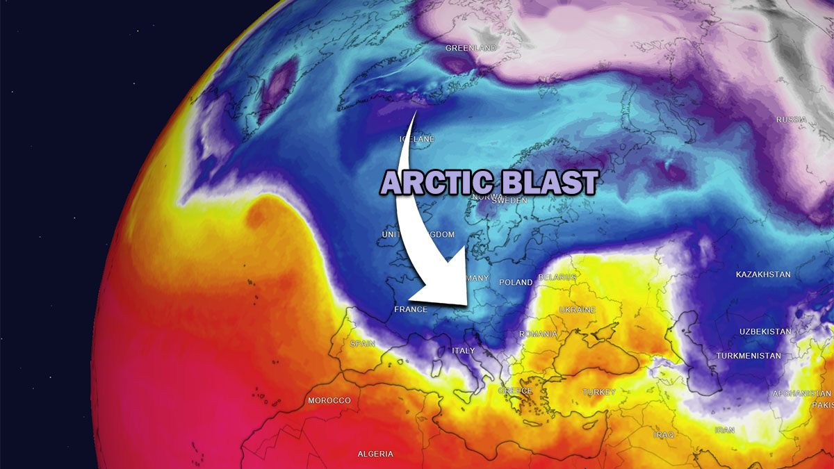
The evolution of the progressive weather pattern dynamics is best represented in the video animation below. We can clearly see how a huge reservoir of much colder-than-normal air mass is forecast to spread into Europe, sending countries into the coldest days for the winter season so far.
The next days, possibly even extending into late next week, will see pretty cold mid-December weather, which should bring winter storms, snow, local blizzards, and significant amounts of rain with flooding for parts of the Mediterranean region.
Let’s now dig into details to see how the cold blast will take its steps over Europe.
POWERFUL BLOCKING HIGH OVER THE ARCTIC, PUSHES DEEP TROUGHS AND COLD BLASTS TOWARD EUROPE
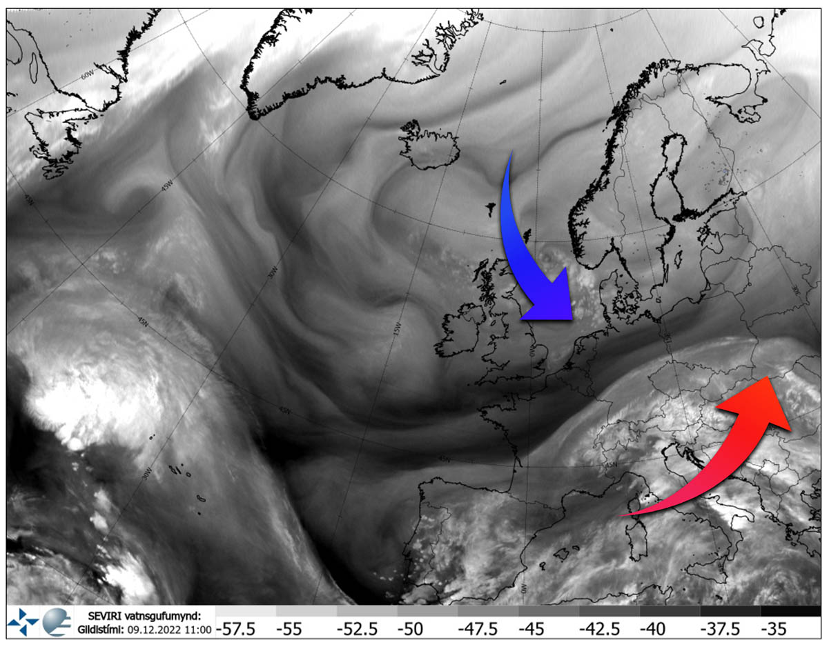
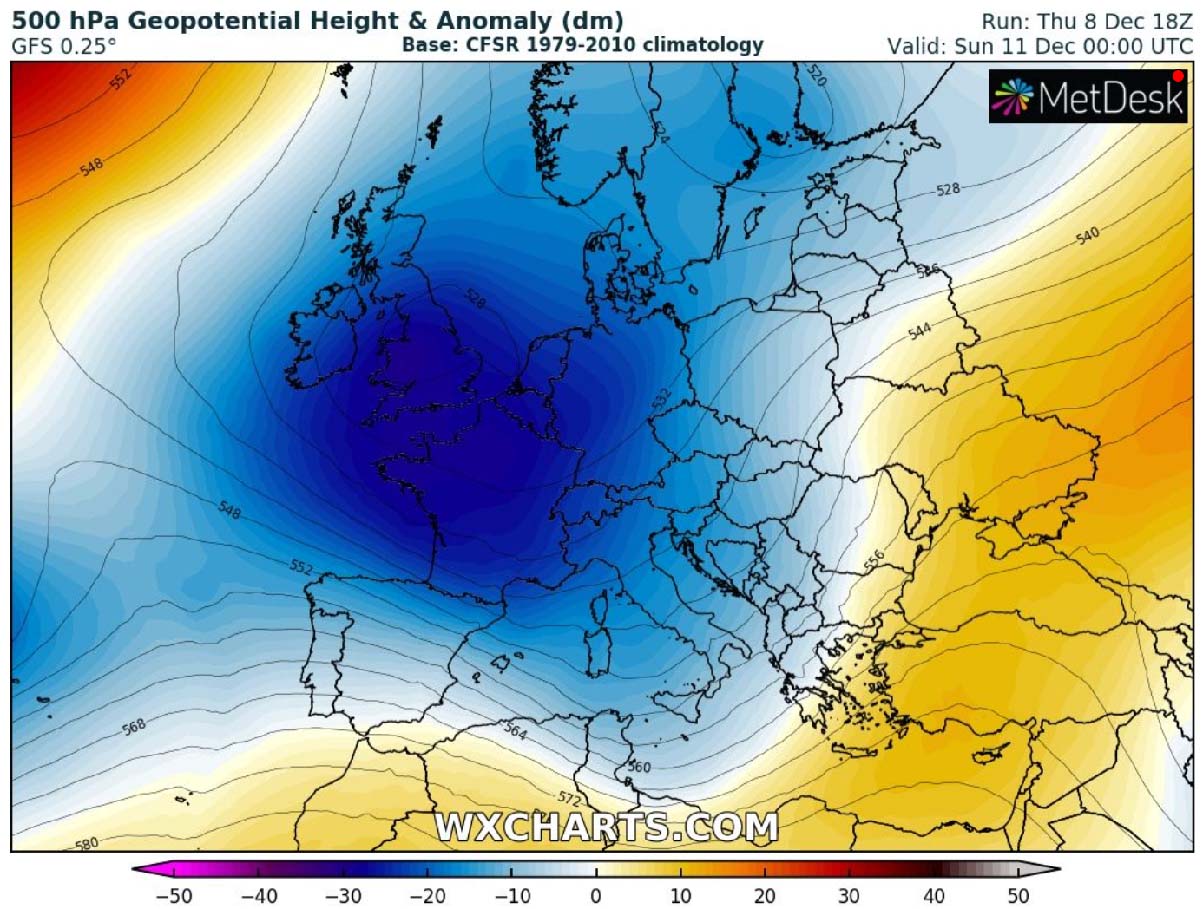
Analysis of the satellite imagery across Europe and the North Atlantic paints an interesting picture with a strong zonal flow established across the southern portions of the European continent. This sends a much warmer and very moist air mass from the Mediterranean towards the east-northeast. To the north, we can see a large pool of much colder weather developing over Scandinavia and the North Sea.
This is the start of the most significant Arctic cold blast this winter season 2022/23. The arrival of a much colder Arctic air mass into the region will deepen the upper trough, allowing cold temperatures to spread farther south and also into the lowlands.
While we can see the low and its core relatively small today, it will become much larger as we head into the weekend. Thanks to the deepening upper levels as mentioned above. This will increase the wind flow in between the colliding colder air from the north and much warmer from the south. Therefore, frontal systems will develop and help to intensify the advection of cold air mass into western and central Europe in their wake.
A STRONG LOCKED-IN PATTERN DEVELOPS OVER EUROPE THIS WEEKEND, PERSISTING INTO NEXT WEEK
As the weekend starts, the upper-level ridge over the far North Atlantic and the Arctic will help to develop a channeling flow of significantly colder air toward Europe. First, days will become much colder over northern and western Europe, gradually also over central Europe.
A large and deep upper-level trough will develop, completely dominating the weather across Europe for several days.
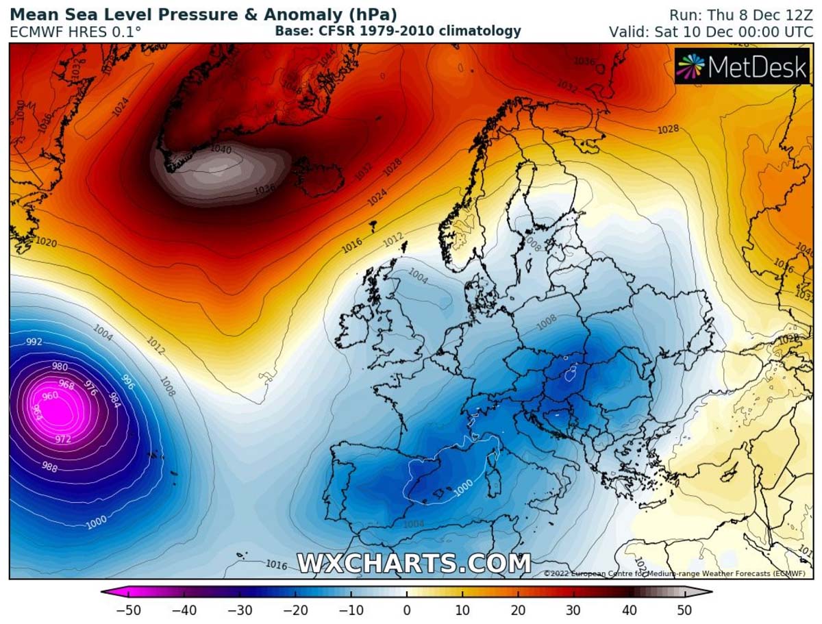
At the surface, very high pressure will maintain over the far North Atlantic, connecting with the High over Greenland and the Arctic region. While lower pressure will gradually establish over most of Europe this weekend.
The strong High over the northern Atlantic will be powerful enough to block the zonal flow so that the air masses will be blowing from the north for quite some time. Thus maintaining cold weather for several days. Days will be gradually colder from today onwards, at least until Tuesday.
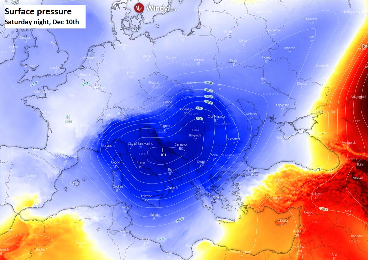
A frontal system with a winter storm will develop across the northern Mediterranean and central Europe.
So, as the blocking zonal flow turns, the air masses become more meridional, and coming from the north, significantly colder temperatures will overspread the European continent. There will be a strong temperature contrast between the west and east on Saturday, thanks to the winter storm on the edge of the Arctic blast.
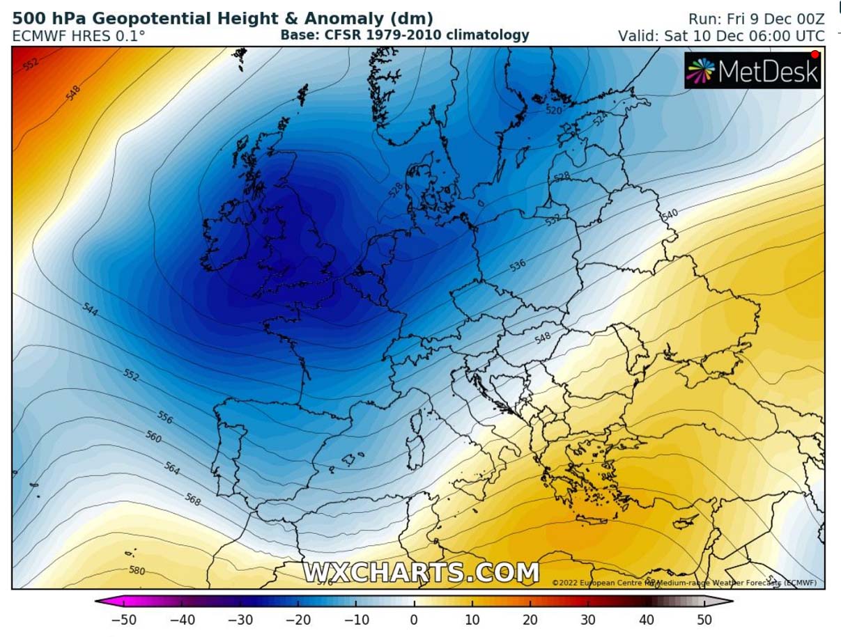
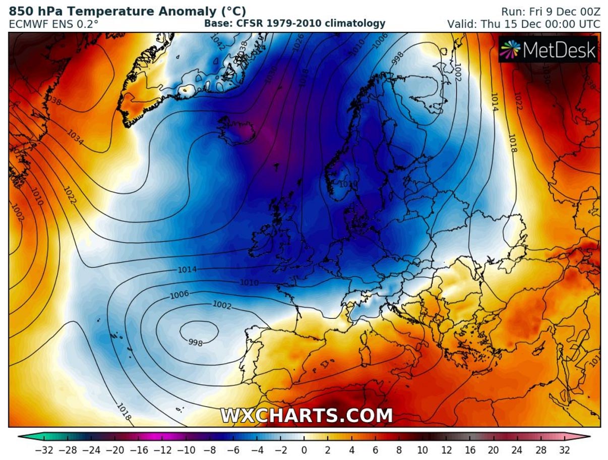
The temperature anomaly chart below hints at how this pattern is evolving. We can see the warm air developing into the Balkan peninsula, Ukraine, and the Black Sea, while a large pool of strong cold spreads across the west.

So the virtual channel is being established in between the two large-scale features, the Arctic upper High and the deep trough over western Europe. Connecting with the Arctic cold air masses will deliver the coldest air or the winter season into western and central Europe.
AN ARCTIC BLAST SPREADS THE COLDER TEMPERATURES THIS WINTER SEASON INTO A LARGE PART OF EUROPE
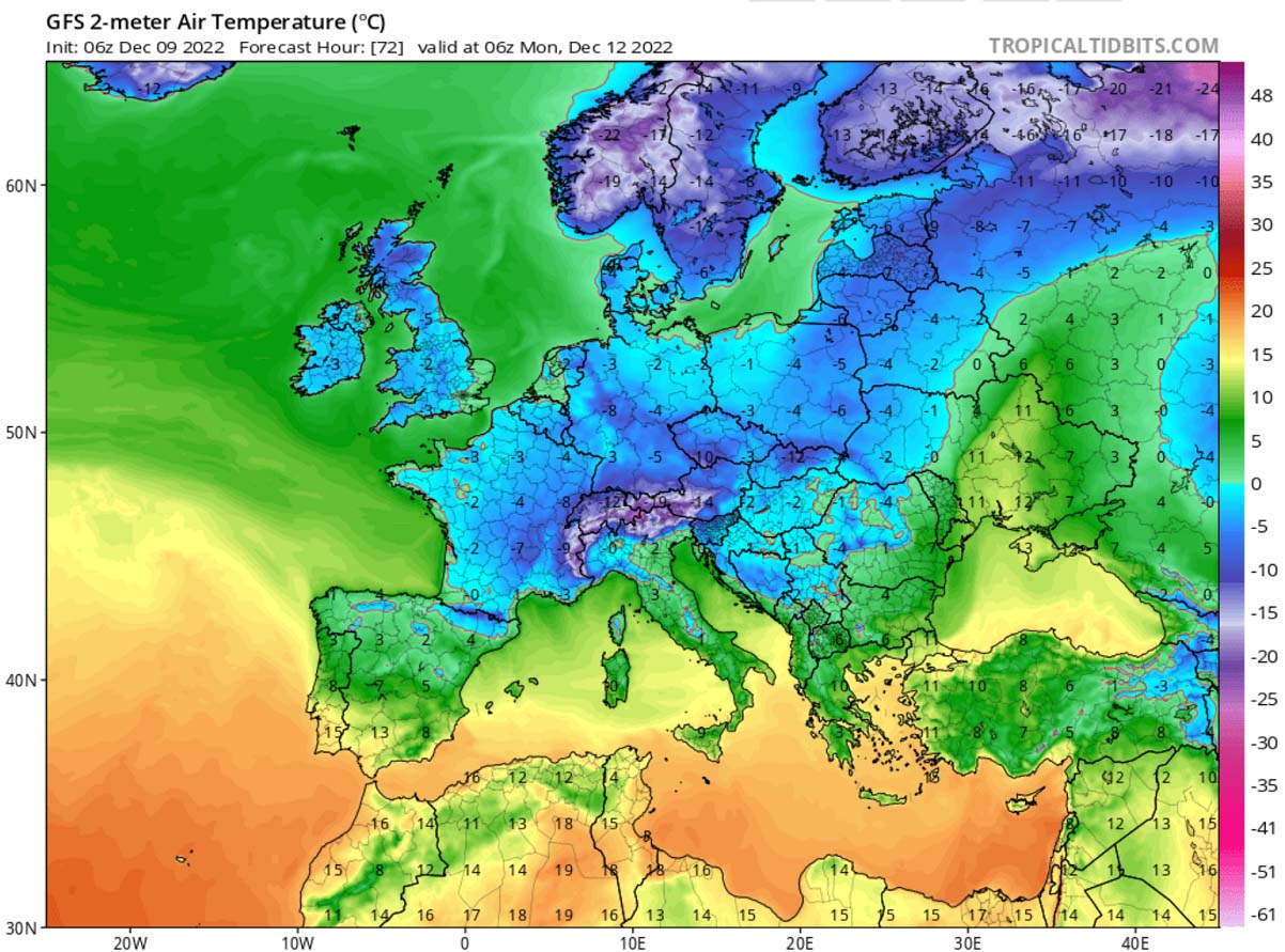
The real blast of much colder air mass Europe has been experiencing so far this December begins on early Saturday. The general weather pattern gets in a higher gear. As the North Atlantic upper ridge (High) and surface High slide south, it introduces stronger meridional northerly flow into the western half of continental Europe. And this forms a large and deep upper trough, growing bigger and deepening across much of Europe.
A powerful upper low/trough will develop and persist for days, forecast to bring much colder weather over the next 5-7 days for many. The trough will expand east and south on Sunday and Monday, spreading across central Europe as well.
Once such a large-scale feature matures, a huge and deep pool of much colder than normal air mass will begin its progress towards the south. Overspreading western, central Europe and later on also eastern Europe and the Balkan peninsula early next week. Temperatures are forecast to be more than ten °C below average for mid-December.
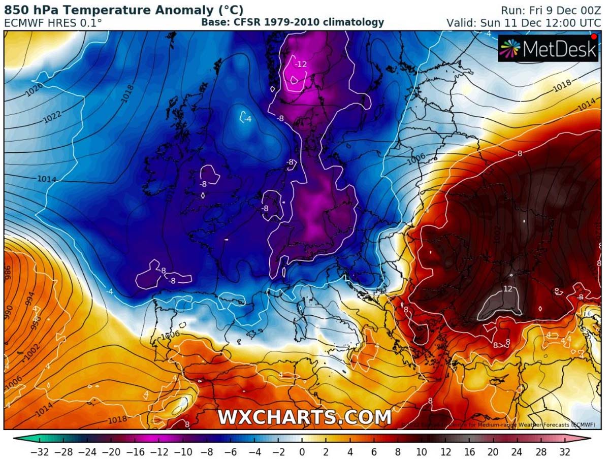
As we can see above, the central and western parts of the European continent are forecast to experience a much below-normal temperature as the weekend unfolds, and it continues into next week. Actually, the majority of Europe will see colder weather, except the far southern and southeastern Europe, before the cold mixed there as well.
The warmth ahead of the winter storm will be strongly anomalous over the Balkans and the Black Sea region, more than 10 degrees C warmer.
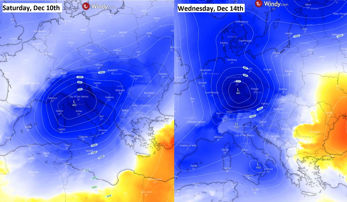
With the eastward progress of the deep low moving across central Europe and the northern Mediterranean through Saturday and Sunday, the cold follows in its wake. Also, vanishing the warmth on its front end farther east and cooling down the air mass also across eastern Europe. The low-pressure system should not be particularly deep, but it will be pretty large to support heavy rain to the south of the surface cold front and heavy snow with blizzards to its north.
Farther west over the North Atlantic, the strong surface high-pressure system will remain intact and likely to slide towards the south through mid-next week. This means the zonal flow will remain disturbed and should not bring the warmth back into the continent soon. The potential is gradually increasing. There will be another cold blast following sometime late next week, at least into western Europe. Thanks to the persistent Atlantic High.
The following chart indicates the temperature anomaly on Tuesday next week, where we see a vanishing of the most significant cold pool over central and eastern Europe. But additional cold is already shaping up for the western parts. And should gradually continue spreading south and east later on.

This should, therefore, also increase the chances for snowfall events in western countries through midweek and towards the next weekend.
A TRAIN OF WINTER STORMS DEVELOPS, WITH LOTS OF RAIN AND FLOODING IN SOUTHERN EUROPE. SNOW IS FORECAST FURTHER NORTH
Between the large cold pool to the north and High across southern Europe, a strong west-southwesterly flow will be established from late Friday onwards across the Mediterranean into the Balkan peninsula. This persistent flow will result in high moisture advection from the still warmer seas into the lands.
There will be several frontal systems and winter storms generally moving from west to east across central and southern Europe, thus forming a lot of precipitation. Both rain and snow.
Much colder air across central Europe should finally deliver some significant amounts of snow into the Alps, but also into the surrounding areas given the strong Arctic blast this weekend.
The 10-day snowfall forecast below hints at 50-100 cm or even more snow over the Alps through mid-December. We can see some significant amounts of snow also across the northern Balkan countries, as well as farther northeast into Poland and Baltic countries.

Global weather models also hint at some fresh snow potentially coming up late next week for Germany, France, Benelux, and even UK as well. However, the snow forecast in these regions strongly depends on the weather pattern evolution next week. If the colder temperatures continue, snow will likely develop and blanket western Europe countries.
With the relatively sharp temperature contrast between the north and south, precipitation will be as rain farther south over Italy and the western Balkans. There’s a high probability of flooding waters again across parts of southern Italy and along the eastern Adriatic.
Areas from northwestern Croatia towards the Dalmatia region and to Montenegro are prone to experience heavy and excessive rain during several frontal systems passage in the next 5-10 days. The highest rainfall sums are expected where the typical most significant orographic rainfall occurs. Those areas should expect 200-400 mm of rain over the next 10 days.
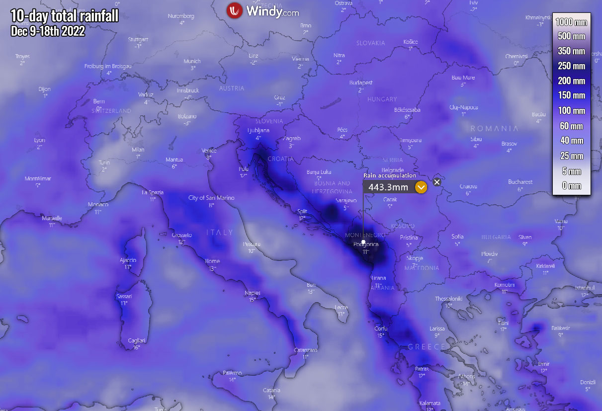
So the general pattern will bring a significant amount of rain and further increase the flooding potential, especially across the southern Balkans. The combination of warm advection and the frontal system should bring very heavy rain, as well as thunderstorms, and possibly severe weather as well.
Also, colder mid-levels overspreading the still-warm Mediterranean should raise the potential for waterspouts or even tornadoes in the far south of the affected regions.
COLD BLAST WILL BE THE REAL STRESS TEST FOR THE EUROPEAN ELECTRIC GRID THIS WEEKEND
With temperatures forecast to fall significantly in the coming days, this is also posing a first major winter test of the region’s energy grids.
Temperatures in many countries across western, northern, and central, as well as eastern Europe, are set to drop well below-freezing levels this weekend into early days next week.
The projected cold blast is considered a significant stress test for Europe’s fragile energy market systems. Note that about two-thirds of Europe’s energy is made by burning fossil fuels (gas, oil, and coal), and gas storage levels play an important role in electricity production.
Europe’s gas storage levels were in a relatively strong position for the evolving winter season. However, parts of Germany may be vulnerable to significant freezing temperatures also due to partial nuclear outages in France.
Countries, especially across western and central Europe, have warned that strained tensions in the energy market could lead to potential power outages and rolling electricity outages in the upcoming weeks as temperatures become much lower.
Both the risk of power outages and much higher prices than last winter season are damaging both the consumers and the industry.

Britain’s National Grid, for example, noted that there are possibilities that households could face blackouts in the afternoon hours if some significant Arctic cold air mass spreads across the UK this winter. It all depends if the gas imports are reduced, despite the storage currently being at high levels.
A similar situation is also warned by French authorities.
Also, the Nordic European countries have warned citizens of potential power outages, which have increased due to uncertainty in domestic energy production and foreign both gas and electricity imports.

So, the general weather model consensus is still a bit uncertain about the pattern evolution in mid-next week. It depends on the North Atlantic dynamics if a strong upper High will re-establish to limit the warm advection (more zonal flow) coming back into the continent.
North Atlantic High into the Arctics normally maintains more north-northwesterly flow into the European continent. Below is the global model forecast hinting at its solution, supporting warmth to return into areas south of the Alps but re-intensity into western Europe.
As we can clearly see, the general flow from the Arctic cold to the north could still remain connected to the large cold pool developed over west-central Europe. This could mean that until the westerly flow cuts this channeling flow from the Arctics, the weather pattern should not have many chances to change significantly for western Europe.
In short words, this means the significant cold could extend well into mid to late next week for the western countries, the UK, France, and Benelux in particular.
We can see how the general overlook for the temperature and rainfall forecast for the next 14 days across central, western, and northern Europe appears on the Meteogram charts. Attached below is the GFS model for several European cities to give an idea of anomalous temperatures with this widespread cold blast.

As we can see, a quite long period of much-below-normal temperature is forecast to spread over the weekend, potentially expanding towards mid-December across central and western Europe. Very cold for December will also be across Nordic countries.
Southern countries across Italy and the western Balkans will again be at risk for additional flooding as rain amounts will be very high, as we have seen earlier above.
Images were provided by Windy, Wxcharts, and Wetterzentrale.
SEE ALSO: