Live Tracker: A powerful bomb cyclone, known as Storm Goretti, is on the way to Western Europe tonight, impacting southern UK, the English Channel, and northern France.
A rapidly developing Atlantic low was named Storm Goretti by Météo-France, as its effects are forecast to be significant. Storm is expected to produce a sting jet wind maximum with severe, potentially damaging winds.
Parts of Wales and south-central England could see 15-30 cm of snow, as the colder side of the low develops an environment conducive to heavy snowfall as the storm’s core travels across the English Channel tonight.
A few Key Highlights with Storm Goretti overview Thursday night:
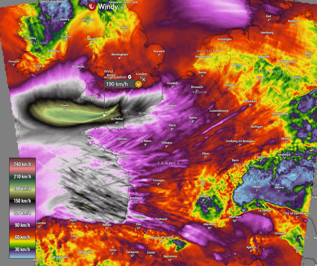
The Sting Jet winds: We are monitoring the potential for a ‘sting jet’ wind maximum, a narrow corridor of particularly intense winds that can form in rapidly intensifying Atlantic storms. This wind maximum could lead to localized gusts significantly higher than those of the surrounding storm, 180-200 km/h (120+ mph) across the English Channel and the coasts of northwestern France.
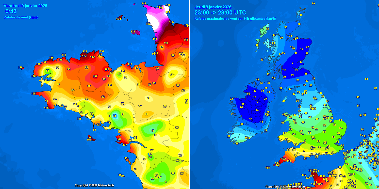
Warnings in effect: Red Warnings are in place for Cornwall and the Isles of Scilly, where gusts could reach 80–100 mph (140-160 km/h) in exposed areas. Much of the South West and South Wales will see 60–70 mph winds.
The snowstorm impact: As the storm’s moisture meets with colder air mass on the northern side of its core, parts of the Midlands, Wales, and Northern England could see 15–30 cm (6–12 inches) of snow overnight. Snow will be heavy, combined with strong winds.
Note: The following posts are live tracker updates as the evolution unfolds. The last update is always at the top of the article.
EXTREME peak wind gusts of 213 km/h reported at Cotentin Peninsula, Normandy, France
Update: Jan 9th, 00:30 UTC
The full power of the sting jet wind maximum core has blasted into the Cotentin Peninsula, France. The weather station Barfleur – Gatteville-le-Phare has reported EXTREME wind gusts up to 213 km/h!
In addition, other stations across the peninsula have also reported higher gusts than before: Barneville – Carteret – 182 km/h, Saint-Vaast-la-Hougue – 177 km/h, Cap de la Hague – 157 km/h, Vigiu Du Humet – 152 km/h. Up to 157 km/h was also reported further northeast along the Normandy coast, in Fécamp.
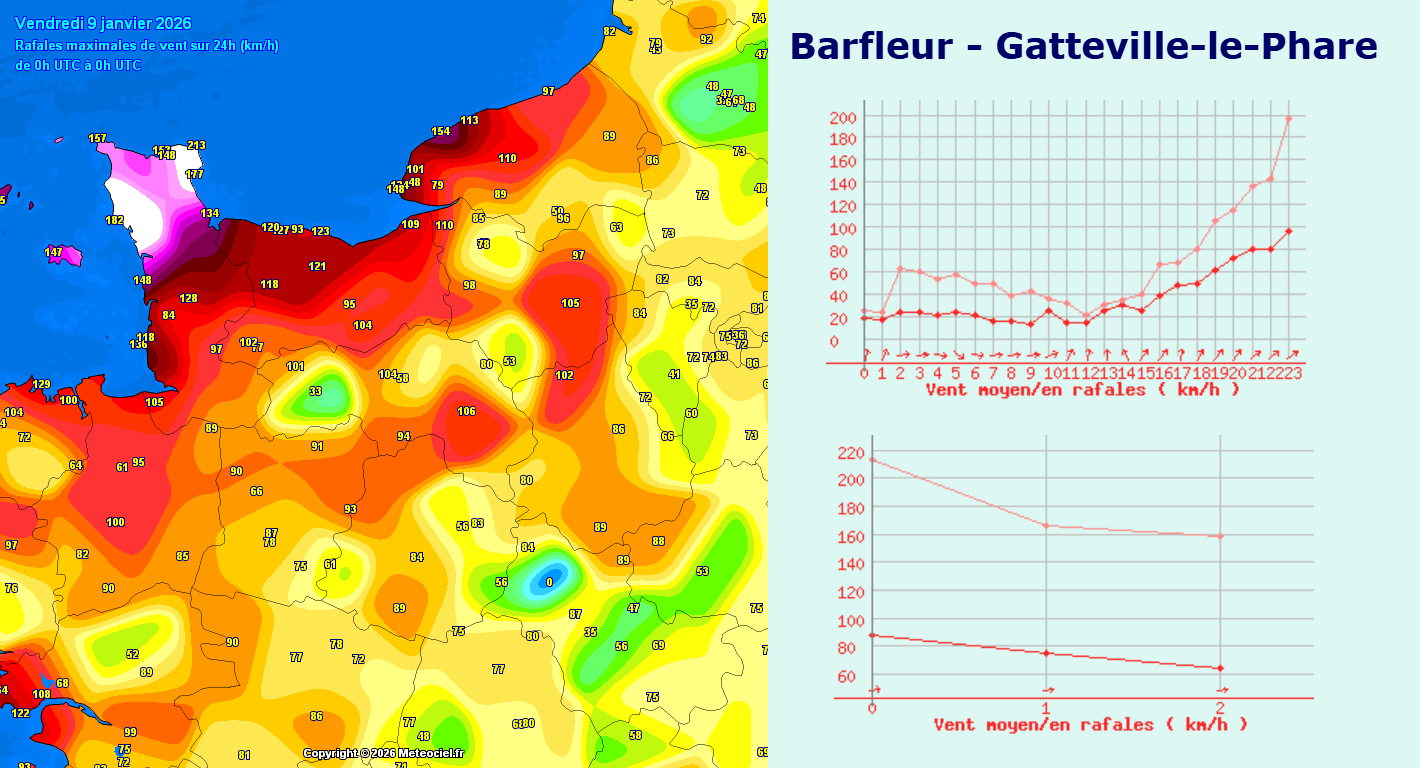
We are awaiting confirmation of the official report from Meteo France, but wind gusts this high are near the absolute record values for the Normandy coast! Damage will be significant. Stay tuned for more updates on Friday.
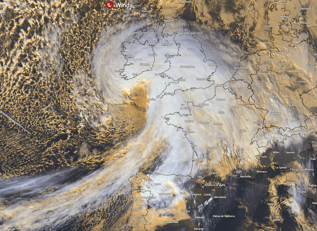
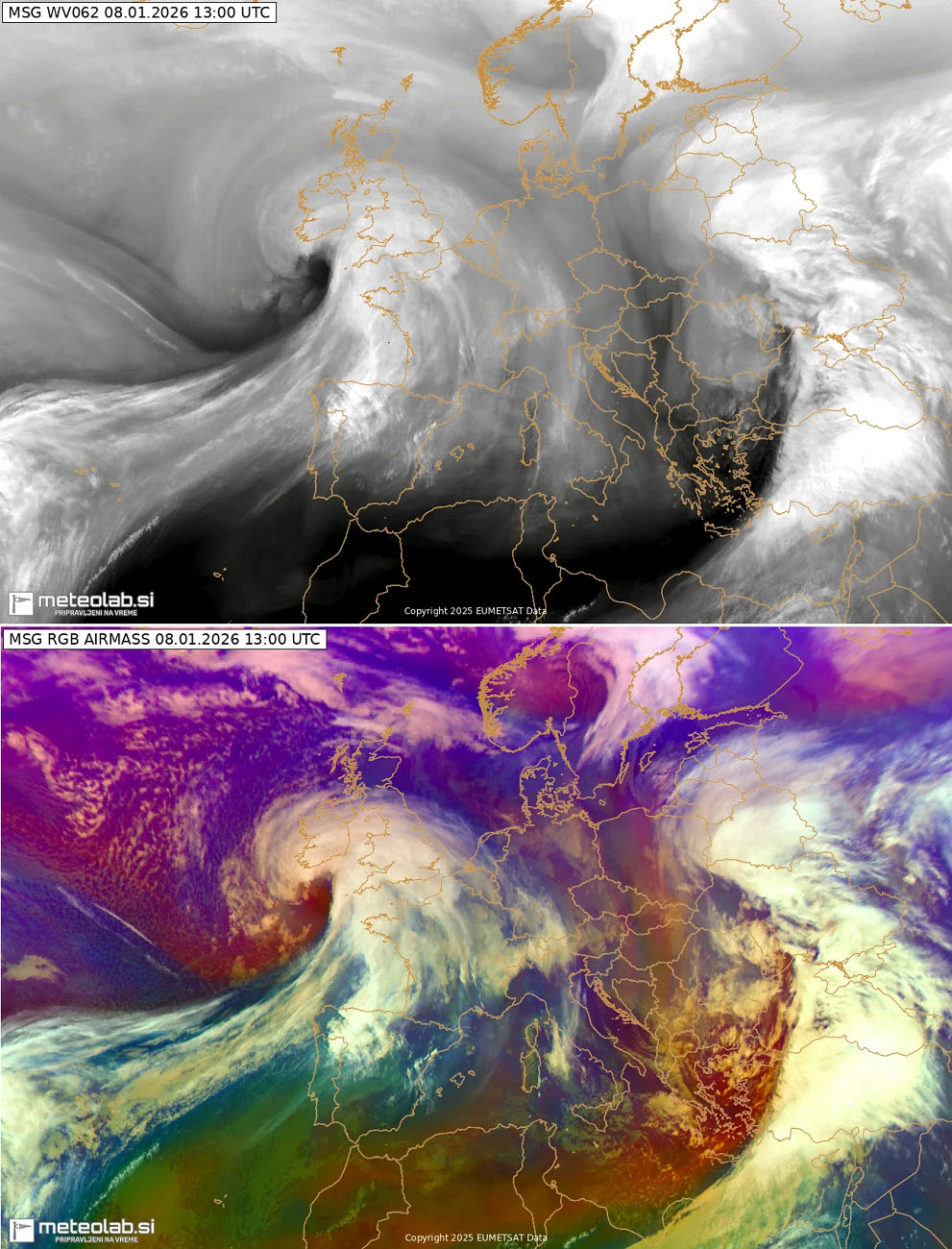
An outstanding water vapor and airmass satellite imagery
Update: Jan 9th, 00:00 UTC
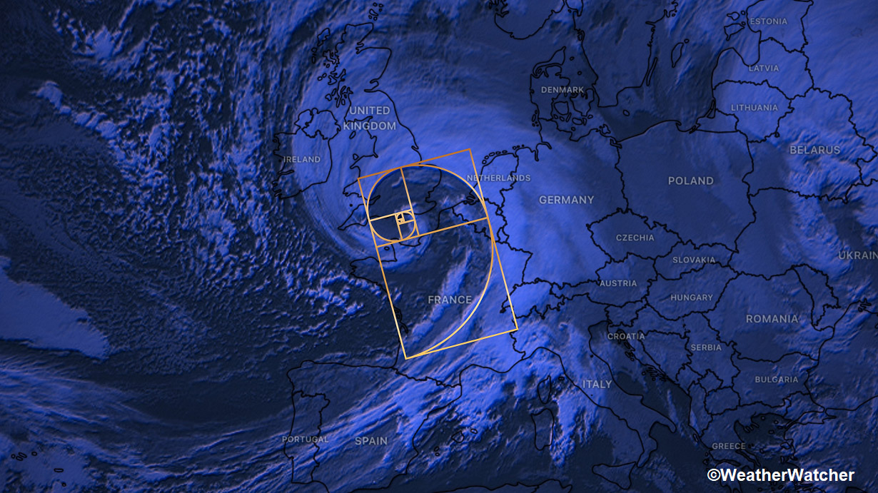
Wow, that’s the first raw expression one could say. What an outstanding satellite presentation the system is becoming as Goretti is nearing its peak intensity now.

Despite being extremely dangerous and destructive, satellite imagery is astonishing. We have also prepared an animation of both satellite channels; see it below.
This is as perfect as it gets, and it also extends the Fibonacci sequence.
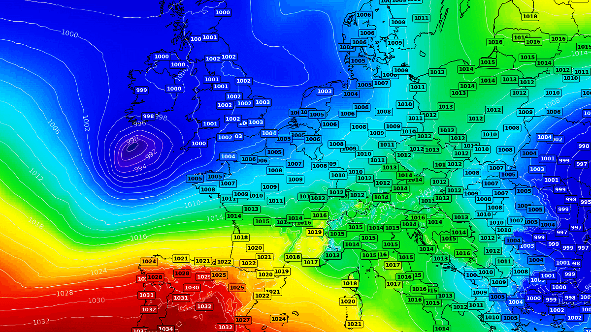
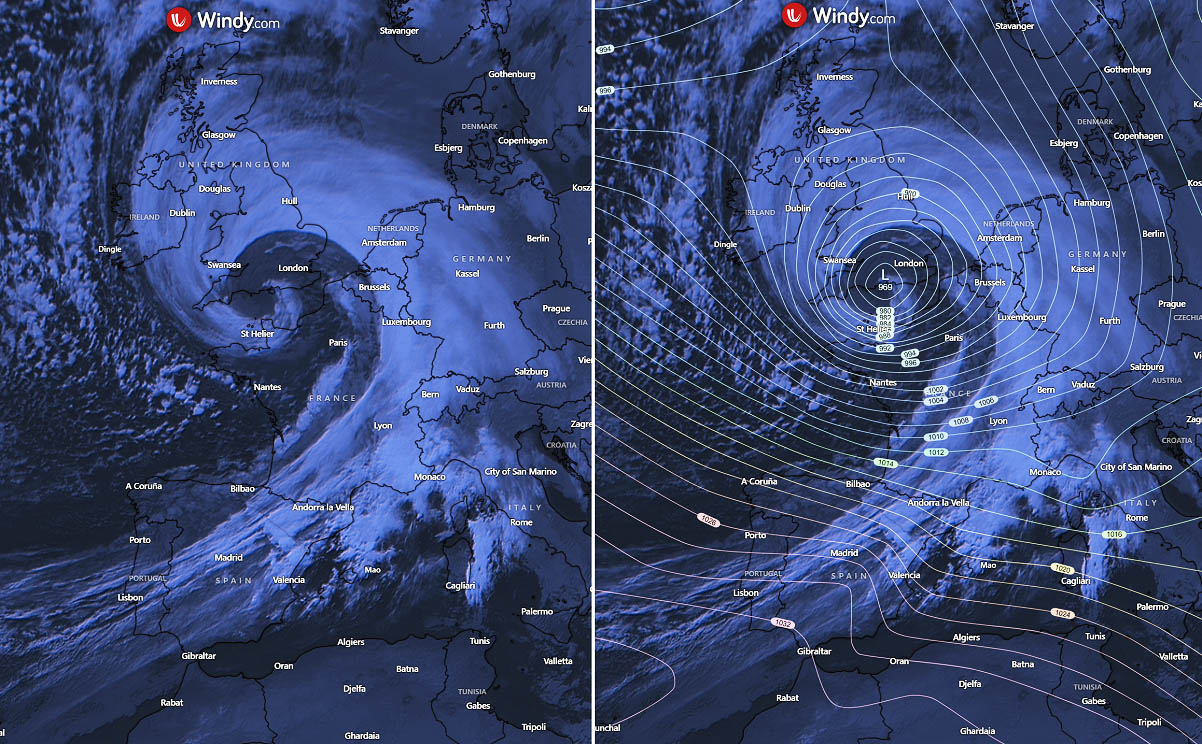
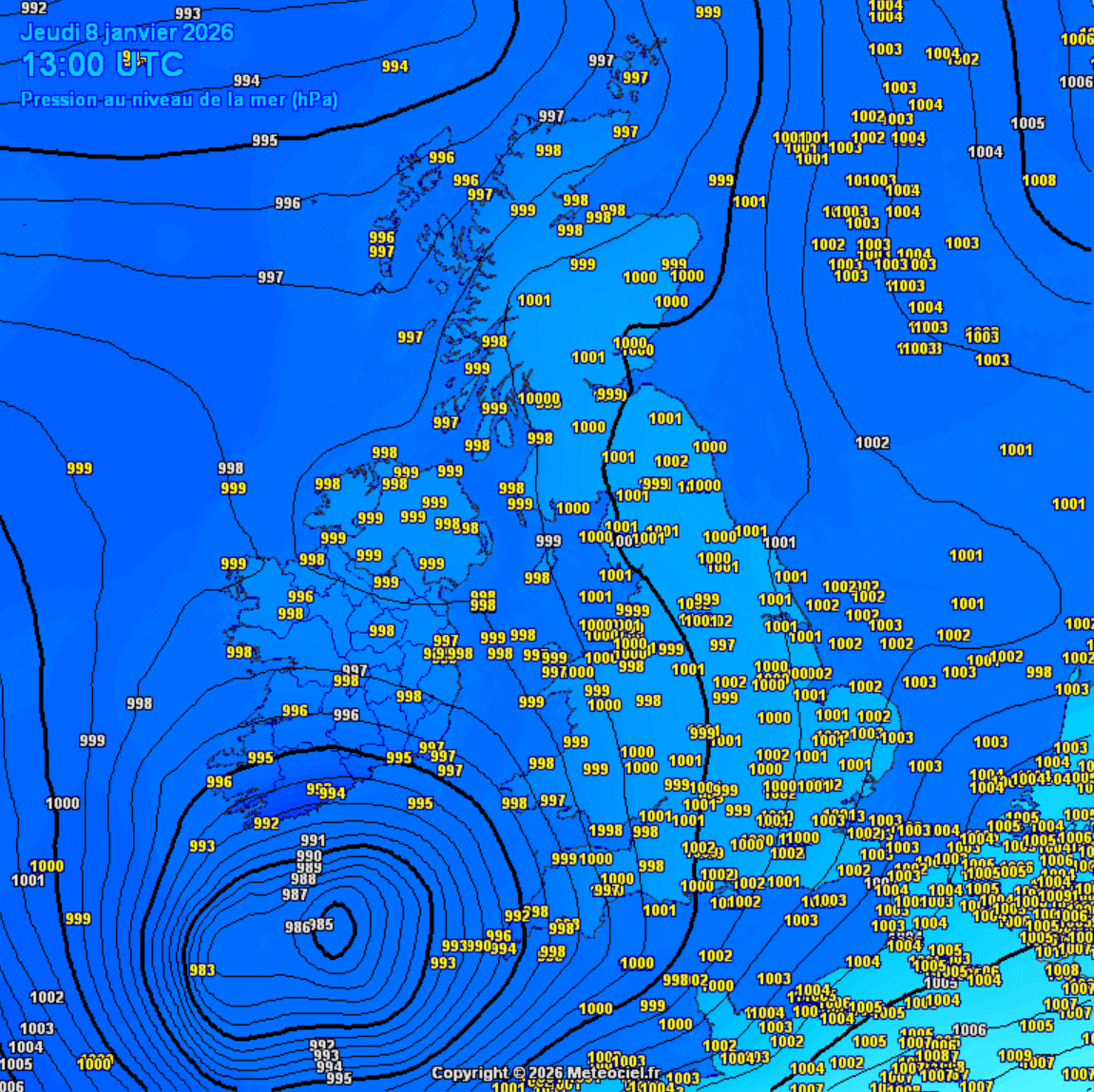
Central pressure down to 966 mbar along southern England
Update: Jan 8th, 22:30 UTC
An impressive look at the pressure analysis across Western Europe remains. The central pressure has now reached down to 966 mbar and has not bottomed out yet, and a few mbar lower values are possible as Storm Goretti continues across the English Channel tonight.

A sharp pressure gradient is resulting in violent, destructive winds battering the Cotentin Peninsula in Normandy, France, with wind gusts of nearly 200 km/h!
Multiple weather stations reporting 160-200 km/h wind gusts with *extreme* pressure falls
Update: Jan 8th, 22:00 UTC
The core of Storm Goretti has moved across multiple weather stations along the Cornwall (UK), Brittany, and Normandy (France), with both peak wind gusts and pressure falls.
With observed 36-38 mbar over the last 12 hours, that is more than double the bombogenesis criterion. These pressure falls are *extreme*!
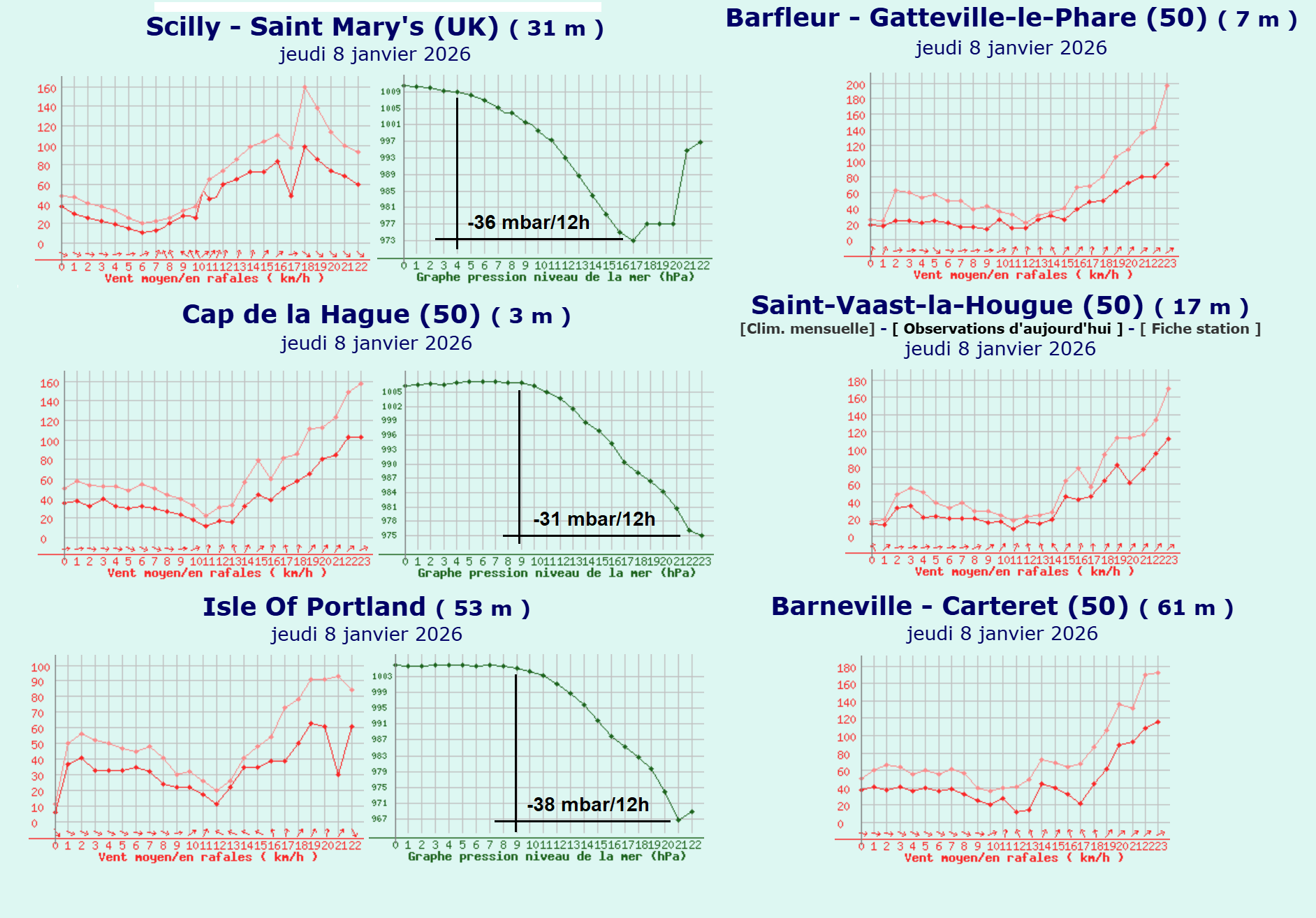
175 km/h peak wind gust – Barneville – Carteret, France
171 km/h peak wind gust – Saint-Vaast-la-Hougue, France
166 km/h peak wind gust – Barfleur-Gatteville-le-Phare, France
160 km/h peak wind gust with 36 mbar pressure drop in 12 hours – Aint Mary’s (Scilly island), UK
157 km/h peak wind gust with 31 mbar pressure drop in 12 hours – Cap de la Hague, France
38 mbar pressure drop in 12 hours – Isle of Portland, UK
Satellite view presents a mathematical perfection – The Fibonacci sequence
Update: Jan 8th, 21:00 UTC
The look over the infrared satellite channel reveals how impressive and intense the Storm Goretti is tonight. Its shape perfectly resembles the Fibonacci sequence.
The central pressure has fallen below 970 mbar, and it continues to deepen as the storm grazes further east across southern England and the English Channel.
198 km/h reported in Padstow, Cornwall, UK
Update: Jan 8th, 19:30 UTC
The first impact of the sting jet wind maximum is blasting Cornwall. The weather station in Padstow reported a 123 mph peak wind gust or 198 km/h at 19:27 UTC.
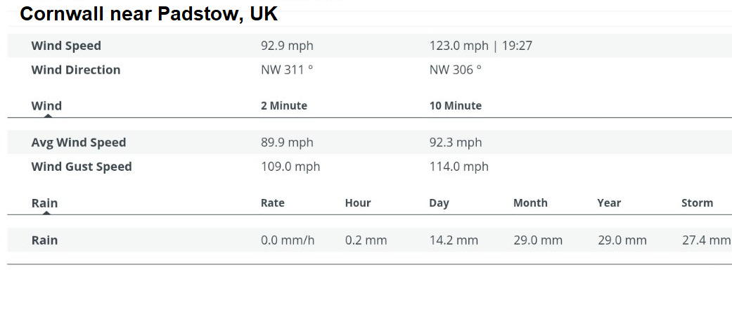
The 2-minute average wind speed was 90 mph (145 km/h), while the 10-minute wind speed was 92.3 mph (148.5 km/h).
Upgrade: RED Warning for Cornwall and the Scilly Isles issued
Update: Jan 8th, 14:30 UTC
Confidence has increased that violent wind gusts up to 100 mph (160 km/h) are also likely to affect Cornwall and the Scilly Isles this evening.
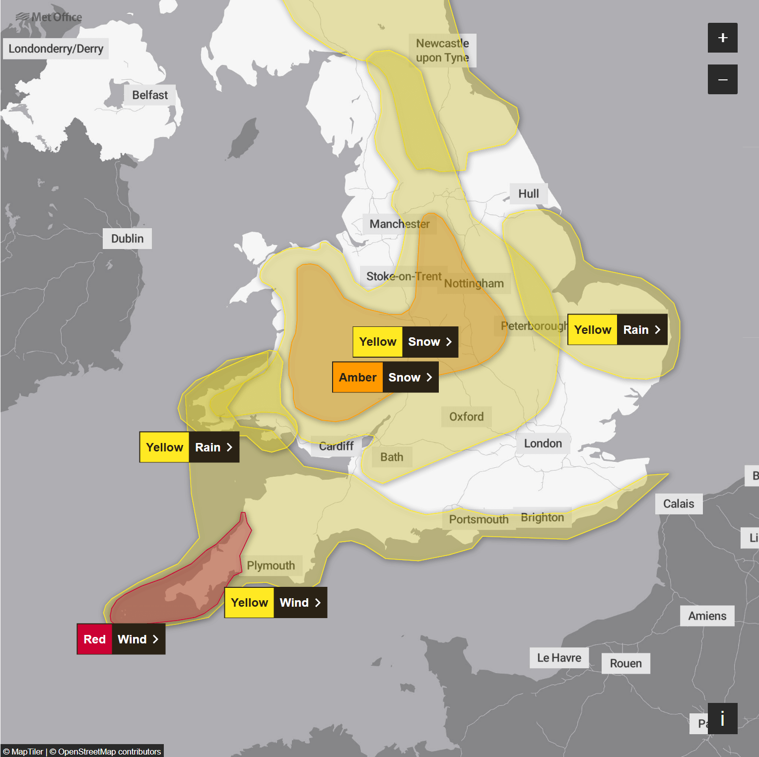
Warning update from MetOffice: Storm Goretti will bring a period of exceptionally strong northwesterly winds to the Isles of Scilly and parts of Cornwall on Thursday evening, with peak gusts of 80-100 mph or more in exposed areas.
Winds are expected to increase rapidly from 30-40 mph with violent gusts that may persist for 2-3 hours before easing. Winds will remain strong with the broader yellow warning in force until Friday morning.
The current view over the visible satellite channel reveals a large Atlantic storm on its way into Western Europe, with undergoing strengthening and shaping up for a significant impact later today and tonight.
The system began its journey on Wednesday night and is travelling east across the Atlantic towards Europe today.
The central pressure is falling rapidly and is expected to deepen further over the next 12 hours, meeting nearly a double-bombogenesis criterion for a bomb cyclone.
This means that the pressure falls will be more than 24 mbar in 24 24-hour period.
Storm Goretti will move due east over the next 24 hours, across the English Channel towards Benelux, with significant impacts across southern England overnight, then across Northern France, Belgium, and the Netherlands Friday morning as it finally slows and begins to weaken.
The following video reveals its impact and track.
Before we dig into some more details about the storm’s impact, let’s examine details about the Sting Jet wind maximum, which could bring a dangerous, violent wind impact along the southern side of the Goretti’s core tonight.
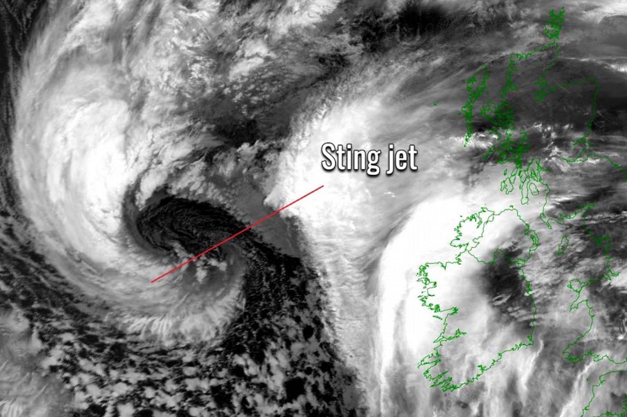
What is a Sting Jet?
A sting jet is a narrow core of violent winds that sometimes forms within rapidly intensifying extratropical cyclones in the North Atlantic and North Pacific, producing powerful windstorms near the ground. Sting jets are associated with the strongest and most damaging windstorms, resulting in violent, hurricane-force winds.
Deep North Atlantic cyclones often graze western Europe, bringing damaging winds and waves. Some are violent and cause significant tree and structural damage. There have been Storm Eunice, Storm Leslie, Storm Jorge, and Storm Ophelia in recent years.
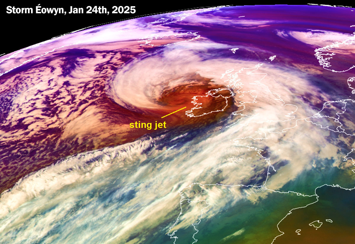
The most recent violent Atlantic storm was Éowyn on January 24th, 2025. Storm Éowyn brought destructive wind gusts, with a textbook sting jet visible on satellite imagery.
Sting jet is the meteorological phenomenon blamed for producing violent, hurricane-force winds with the most notable events. This phenomenon produces a swath of particularly intense winds, often resulting in peak wind gusts well above 150 km/h (90 mph). Sometimes, it even surpasses 200 km/h (125 mph), causing extensive severe damage.
The extratropical cyclone has two frontal zones, the warm front and the cold front following it. A strong flow of cold air develops into the cyclone ahead of the warm front, known as the cold conveyor belt.
Behind the main cold front, a colder and much drier air mass, often originating from the Arctic region, flows towards the cyclone’s core. It forms a dry intrusion towards the center of a deepening low. The dry intrusion typically rounds the low and emerges from the southwest.
The cold conveyor belt brings cold and moist air and precipitation, such as rain and snow, toward the center of the rapidly developing extratropical storm. At the same time, the dry intrusion brings cooler and very dry air into the cyclone.
As precipitation from the cold conveyor belt falls into the layers of air within the dry intrusion streak, droplets evaporate quickly, further cooling the air mass. This process is known as evaporative cooling.
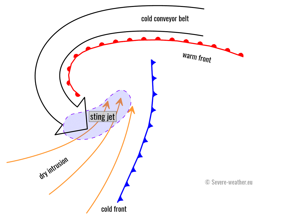
At the final stage of the sting jet process, strong winds descend towards the surface and intensify further as the air parcels dry out. These winds graze through the layers as the air evaporates on the nose of this descending jet. Thus, the evaporative cooling process creates a clear path through the precipitation, making the air much denser within the jet.
The result is the acceleration of the downward momentum, or, in other words, very strong winds are pushed down with higher force towards the tip of the cloud head when it wraps around the cyclone dead center.
Read more about these phenomena: What is a sting jet?
Storm Goretti rapidly deepening as it nears Western Europe
An impressive satellite view as of Thursday afternoon, as Storm Goretti continues rapidly intensifying. Attached below are the water vapor and air mass satellite images, revealing a textbook cyclone development.
The morning Ocean Prediction Center (OPC, NOAA) analysis shows a low-pressure center at 985 mbar, with a rapid deepening phase.
The latest forecast for tonight, 00 UTC Friday, indicated that the low is likely to reach 968 mbar in its core, a significant drop in central pressure. This is why this storm is characterized as a bomb cyclone.
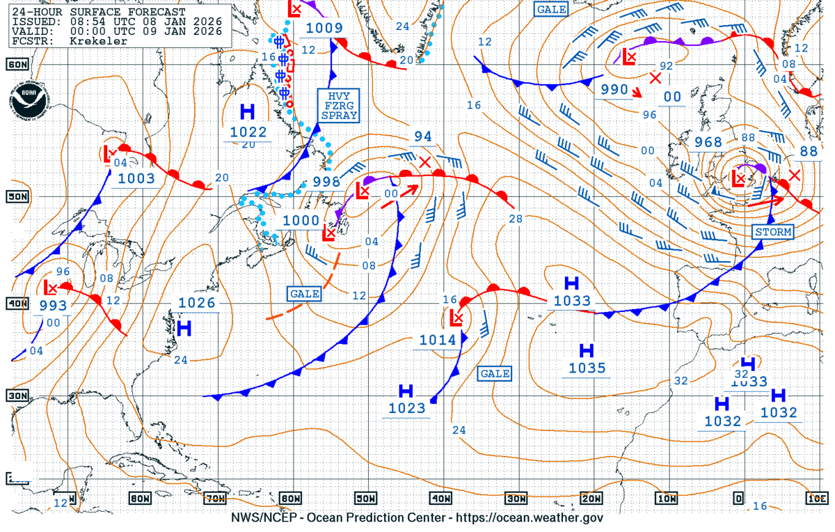
It will produce violent winds and significant wave heights as it grazes into the English Channel, southern England, and northern France tonight through Friday morning.
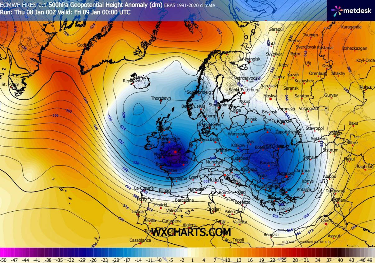
Deep wave moves over Western Europe, Storm Goretti forecast to develop damaging winds and deep snow
The weather pattern over the North Atlantic and Europe indicates that an upper ridge has developed over the Atlantic, with a new deep wave emerging into Western Europe. This is triggering a rapid development of a surface frontal system.
Further east over the continent, a departing wave is over the Balkan peninsula, bringing further snowfall to the region and Eastern Europe.
The surface pressure forecast for Thursday night indicates Storm Goretti will be centered across the English Channel and along the southern England, with the central pressure below 970 mbar.
A tight pressure gradient hints that winds will be powerful on the southern side of the low.
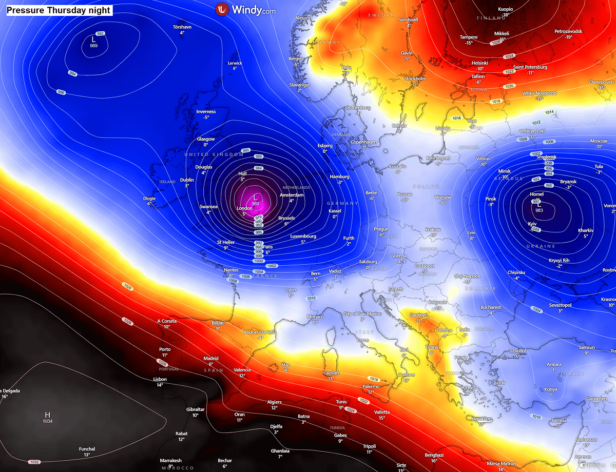
As discussed earlier, it appears likely that the environmental and kinematic conditions are supportive of the development of a sting jet wind maximum near and south of the storm’s core. This means the system could develop powerful, destructive winds exceeding 160 km/h (100 mph).
Those would affect the English Channel region, particularly southwestern England and the extreme north-northwestern part of France. Peak gusts of a fully developed sting jet could reach into the 180-200 km/h range tonight.
Significant winds will also spread around this wind maximum, across western France, and along the northern Spanish coasts. Together with significant wave heights. Winds will gradually weaken when the storm moves further inland towards Benelux by Friday morning.
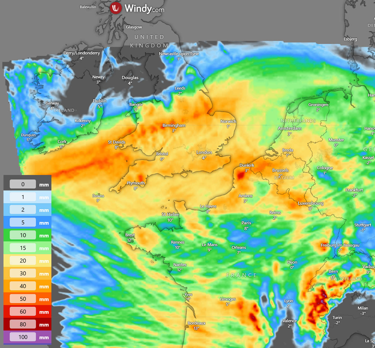
What’s interesting with the storm Goretti is the impact of heavy snowfall across Wales and central England, as the northern side of the low will be cold enough to support heavy snow tonight.
How intense and how abundant the snow will be depends on the position of the center low and the temperatures that will be dragged lower as the core emerges into the English Channel. However, weather models are quite consistent with around 20-30 cm of snow possible, with the ECMWF model being the most impactful and might be overdoing the projections.
Nonetheless, if such amounts do occur, significant travel disruptions are expected across central England through Friday morning.
As the low travels further east on Friday, its associated cold front will push towards central Europe, bringing some snow to France, the Benelux, and Germany, as well as to the Western and northern Alps and the Pyrenees.
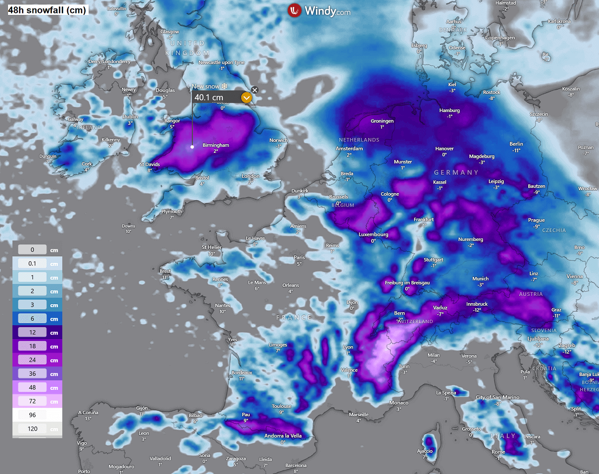
Northern France, however, will remain within the warm belt of the Goretti’s impact; therefore, snow there is only expected once the storm passes. But the front will bring quite a bit of rain tonight, along with violent winds and wind squalls.
Locally, some 30-50 mm of rain will be possible. The snowfall over Wales and England will be wet snow, so the precipitation amount is likely to reach 20-40 mm there, as seen on the chart below.