North Atlantic has been active this month, with multiple storms moving into western Europe. Towards the tropical region, several intense hurricanes formed. Ophelia’s last storm hit the U.S. East Coast and is transforming into an extratropical storm. Its track will bring it to Ireland and the UK as an intense windstorm Agnes on Wednesday.
Given its intensity forecast for the upcoming days, Agnes will become the first officially named North Atlantic storm of the season 2023/24.

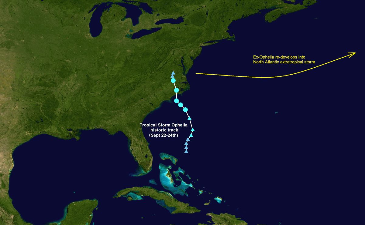
As mentioned, the system originated from the ex-Ophelia storm, a large low-pressure system off the U.S. East Coast. These systems usually have a higher potential to become intense extratropical storms over the North Atlantic.
This kind of cyclone has three key phases of their development: a tropical phase, an extratropical transition, and final re-intensification. During the final stage of rapid strengthening, we also have the warm seclusion life cycle, often found in Europe’s strongest cyclones.
They are characterized by a warm core and a so-called frontal T-bone structure, combined with a northwestward warm conveyor belt and the effects of dry intrusion. Rapid deepening of the central pressure occurs in the latest phase, usually in the last 24 hours before their arrival in Europe.
Agnes will be such a cyclone and gain its strength rapidly as it nears Western Europe late Tuesday. The central pressure is forecast to fall for around 20 mbar in a 24-hour timespan and is expected to bottom out just before the impact on Ireland and the UK on Wednesday.
The video above represents storm Agnes’s development from Tuesday to Wednesday, significantly intensifying while moving across the Bay of Biscay and blasting over the British Isles.
This September, the unusually high seawater temperatures in the Atlantic Basin region support stronger cyclones tracking into western Europe. Agnes will be the first officially named storm and the most intense of the autumn season of 2023.
Note that warmer sea waters lead to the highest potential for more intense frontal systems. This affects both the storms in the tropical region and extratropical storms as they turn towards Europe. So, given the warm Atlantic waters still in place, the chances for more storms reaching the European continent are also higher than usual this year.
THE NORTH ATLANTIC REMAINS MUCH WARMER THAN NORMAL INTO AUTUMN SEASON
At the end of July, temperatures at the North Atlantic Ocean surface temperature reached the highest-ever levels in the history of measurements. The daily average temperature of the whole Atlantic Basin was an astonishing 24.9 degrees Celsius (or 76.8 °F).
The Atlantic Ocean water temperatures remain much higher than normal this September, from 29 to 31 °C across the tropical western Atlantic, with around 20 to 24 °C from Northwest Atlantic towards the Bay of Biscay. Northern portions of the Bay have temperatures around 17-18 °C.
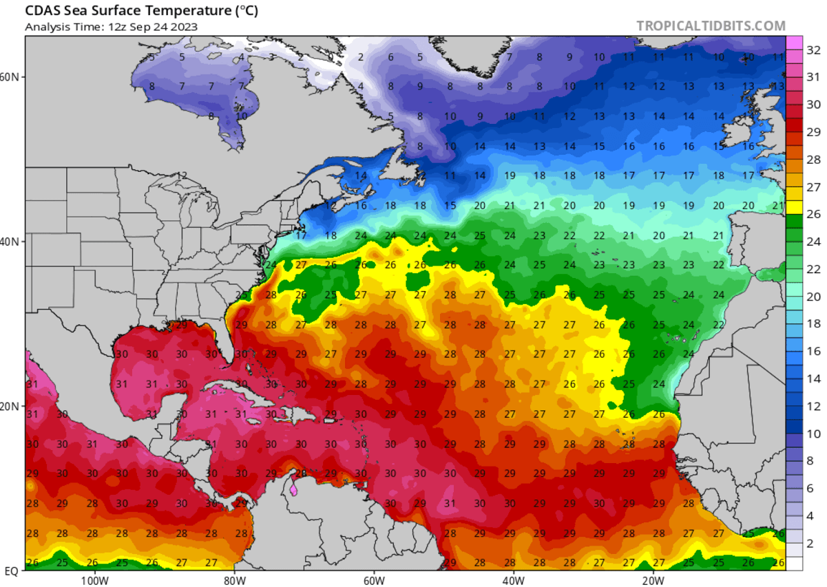
The sea surface temperature in the Atlantic Ocean is generally higher late in the summer. It continues to rise in August towards its usual highest values observed in mid-September every year. Similar water temperature behavior is also observed in the waters around Western Europe.
This week, temperatures across the Atlantic are about 2 to 4 °C warmer than normal, as seen on the chart below. Notice a significant anomaly also over the Mediterranean, the North Sea, and Baltic Sea.
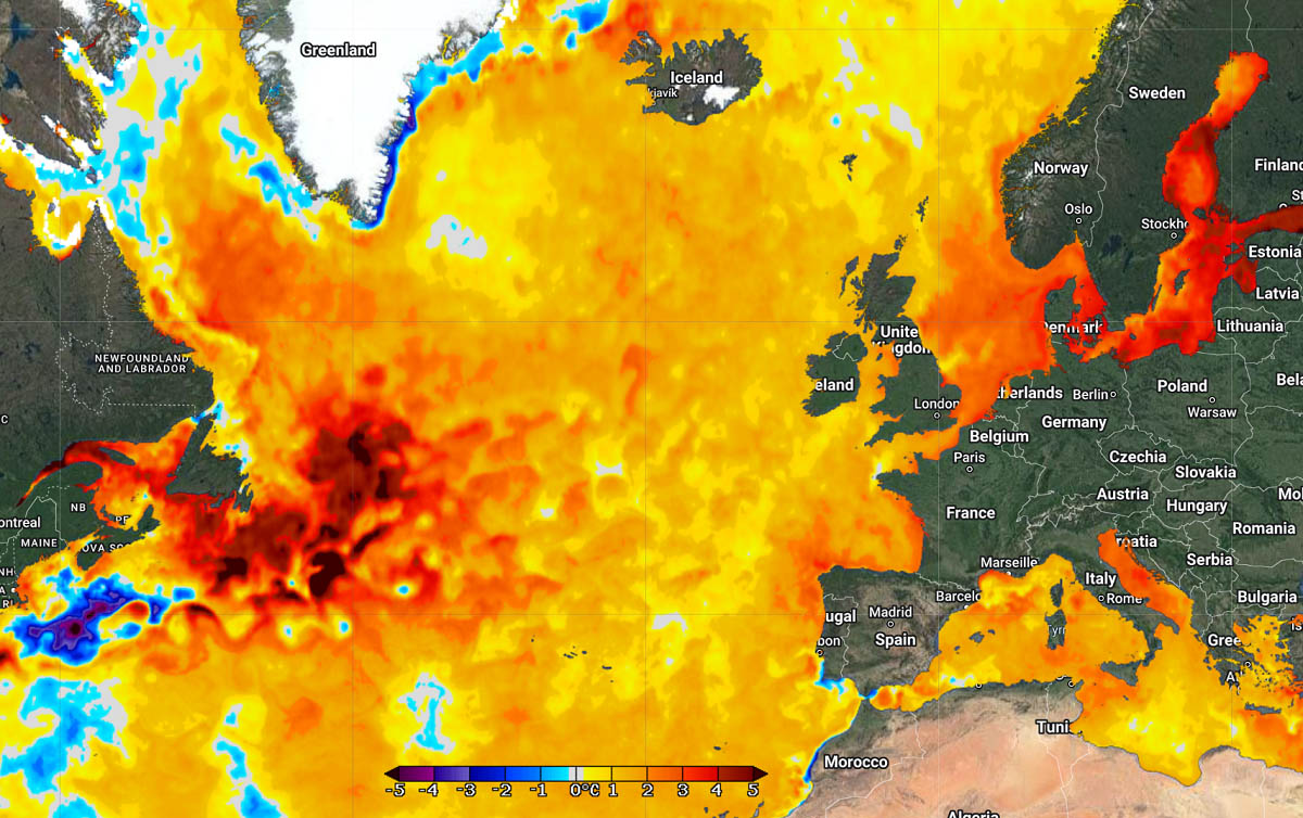
These so-called marine heatwaves are becoming more frequent and stronger in recent years. In 2023, they were and still are more persistent, spread over large areas, and observed worldwide. Note that the 24.9 °C mark in July was more than one degree warmer than a 30-year climatological normal, calculated from 1982 to 2011.
These water temperatures of the North Atlantic will remain sufficiently warm enough to support additional significant tropical and extratropical development in the coming weeks and potentially also months as we head into the next Winter Season.
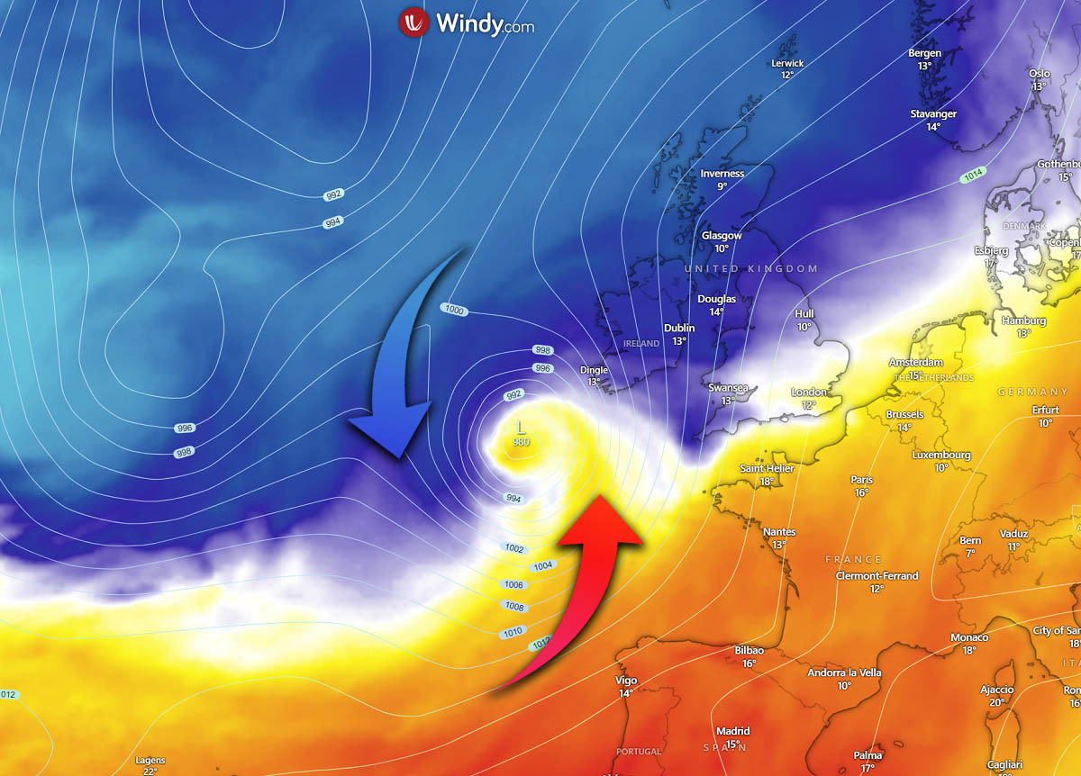
EX-OPHELIA TRANSFORMS INTO THE NEXT ATLANTIC MAJOR STORM, HEADING FOR WESTERN EUROPE
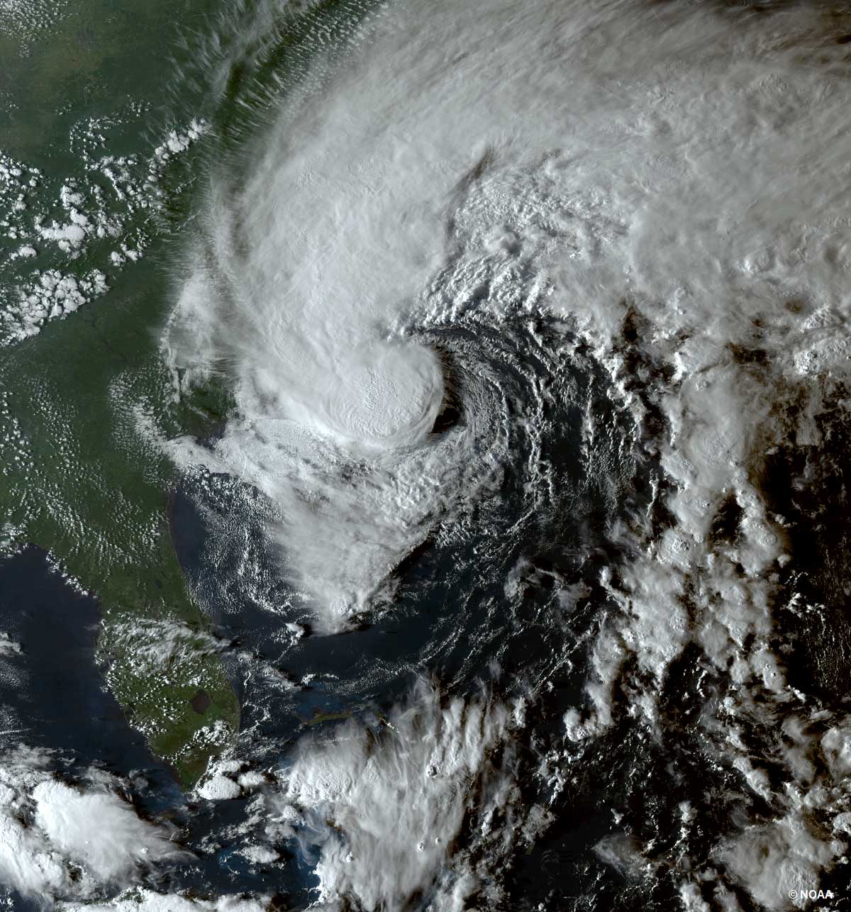
Tropical Storm Ophelia was the recent active storm in the Atlantic Basin, originating from the Bahamas and impacting the U.S. East Coast, dumping a lot of rain over the Carolinas. Over the weekend, it transformed into a post-tropical storm and ejected off to the Atlantic.
The weather model wind and rainfall track guidance suggests that the remnants of Ophelia will re-intensify as they move east across the North Atlantic. Its extremely warm sea waters and interaction with cold air from the north will strengthen the system into a powerful extratropical storm Agnes.
Agnes will become a better-organized and deepening cyclone on Tuesday, rapidly intensifying its wind structure overnight to Wednesday. The cyclone will strengthen more rapidly as it travels across warmer-than-normal Atlantic seawaters.
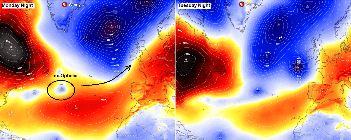
The pressure forecast charts for Monday and Tuesday nights across the North Atlantic reveal how fast and rapid development of this extratropical storm is expected. Once the ex-Ophelia is off the Northwest Atlantic, it will become a powerful storm Agnes as it nears western Europe Tuesday night into Wednesday morning.
With a large low-pressure area, a cold pool to the north, and its tropical origin, Agnes will intensify fast and develop a warm seclusion, as discussed earlier. It will become the most intense storm in the autumn season so far.
Storm Agnes is forecast to track across the Bay of Biscay from Tuesday into the night to Wednesday. During its intensification phase, it will threaten ships across this part of the Atlantic.
RAPID DEVELOPMENT OF A MAJOR STORM AGNES BEFORE IMPACT ON IRELAND AND UK ON WEDNESDAY
The following chart represents the peak wind gusts swath around western Europe over the next three days. We can see how Agnes becomes a violent storm as it tracks across the Bay of Biscay toward its impact on Ireland, the southwestern UK, and Wales.
The peak wind gusts when it approaches the coastal areas of Ireland and the UK could reach 90-100 mph (150-170 km/h) on Wednesday morning.

Given the rapid intensification of the storm and its origin, Agnes could also develop a sting-jet wind maximum before its core makes landfall in Ireland on Wednesday. This is also why we expect wind gusts to reach around 100 mph in some areas along the storm’s swath.
A deep central pressure of the system will also generate significant wave heights. The maximum height could be around 10 meters before the storm reaches the southern coast of Ireland and the southwest UK. The highest waves will be from Tuesday night through Wednesday morning.

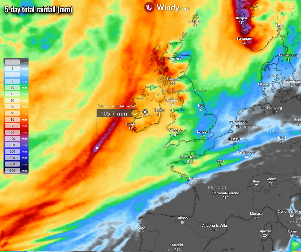
The system will also bring heavy rain squalls when the core reaches the coastal areas. Details of the track can be seen in the video posted earlier.
General weather model consensus suggests that the most rainfall will remain to the west of Ireland.
Agnes will move across the central British Isles on Wednesday, gradually weakening towards Thursday over the North Sea.
Stay alert for gale force winds Tuesday night and potentially a significant impact of violent with gusts and squalls on Wednesday as storm Agnes blasts into Ireland and the southwestern UK during the day.
NOAA, Tropical Tidbits, and Windy provided images used in this article.
See also: