The historic atmospheric Heat Dome is dominating Europe and has obliterated June and all-time high temperature records in the UK, France, Benelux, Germany, and Switzerland. The deadly heatwave is now expanding its lethal boundaries eastward into the continent’s heart over the coming days.
The eastern shift of the heat dome, the mounting death toll, the wildfire and drought conditions are increasing as the historic devastation of the UK and French June, and all-time high temperature records.
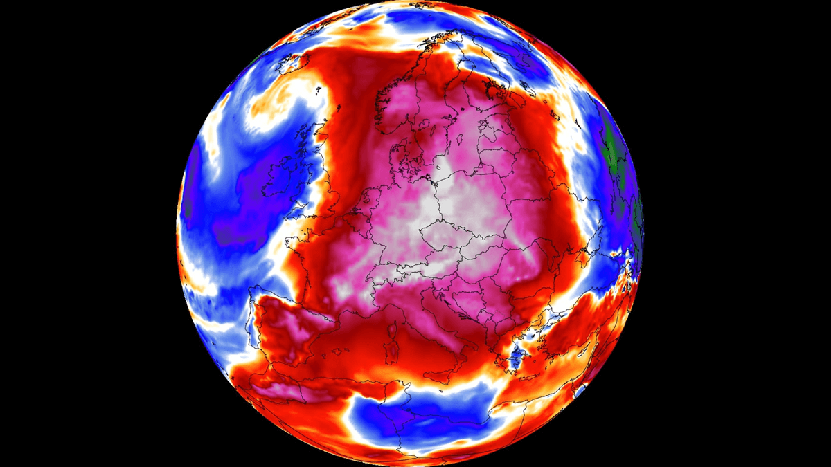
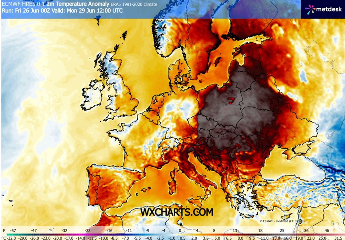
The powerful “Omega Block” pattern has now shifted its center towards Germany, Central Europe, the Baltic States, and the Balkan states. This unrelenting thermal trap is migrating across an already very dry landscape, with temperatures striking even harder than any predictive model anticipated.
The late-June Heat Dome triggered a literal meteorological apocalypse, overwriting hundreds of local and national June and all-time high temperature records across France, the United Kingdom, Switzerland, and Germany. France choked under an unprecedented national average of 30 °C, witnessing the new June record of 44.3 °C. The UK Met Office issued historic, consecutive red alerts as southern England baked in unprecedented, suffocating mid- to upper-30s heat.
Behind this expanding weather disaster lies a trail of shattered historical records and, unfortunately, also a rapidly rising body count. The heatwave has already claimed hundreds of lives from Spain to France in recent days.
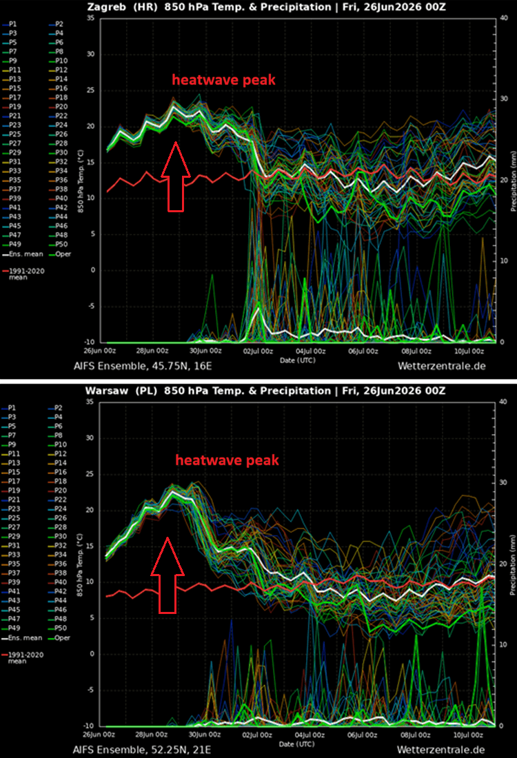
The core of the heat dome parks over Germany and stretches toward Poland and the Baltics over the weekend into the final days of June 2026. National weather services from Berlin to Prague have issued Red Alerts for extreme fire danger, as erratic wind shifts could spark uncontrollable wildfires amid very low humidity and extreme temperatures reaching up to 40 °C.
The combination of extreme heat, exceptionally dry air, and sustained winds causes a sudden acceleration of evapotranspiration and the drying out of vegetation. The consequences can be a rapid, massive leaf loss, mortality of particularly sensitive young plants, severe stress for wildlife and livestock, and a risk of wildfire reaching extreme to very extreme levels.
Before we dig into the details of the pattern evolution in Europe, let’s examine the main driver behind these extensive warm waves and heatwaves.
What is a Heat Dome?
When significant, record-breaking heatwaves occurred in Europe, the United States, and Canada in the past, the Heat Dome was a contributing factor. The heat dome is usually the dominant feature of summer weather patterns on both continents.
We refer to this phenomenon as a heat dome when extremely high temperatures develop. Here’s how it works and why understanding it on a broader scale is essential.
The upper-level ridge pattern, or very warm air mass in the higher altitudes, also known as the Upper High (or blocking High), usually forms the heat dome. This weather pattern brings high, and sometimes record-breaking, temperatures to the region below.
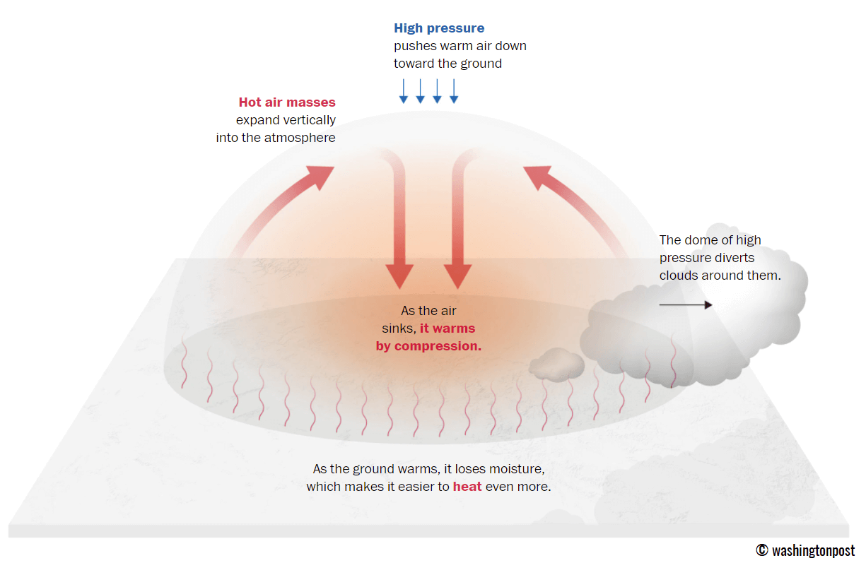
This term is used when a broad area of high-pressure air parks over a large portion of the continent. If the event is remarkably stable and extreme, it usually lasts several days or weeks.
The heat dome works like a lid on a pot. The extensive dome traps warm air at all levels underneath, with layers sinking toward the ground. Therefore, the air mass becomes anomalously warm at the lowest elevations and extremely hot near the surface.
How does a heat dome impact the life underneath?
Excessive heat in heat domes can significantly impact human health and be dangerous to particularly vulnerable populations, such as elderly individuals, children, and those with pre-existing health conditions that can be worsened by extreme heat.
Due to prolonged exposure to high temperatures, construction workers, farmers, and other long-hour outdoor workers are at increased risk of heat-related illnesses. People living in poverty are also more susceptible to the fatalities of heat domes, as their houses are often built with heat-trapping surfaces such as concrete and asbestos.
Heat exhaustion occurs with prolonged exposure to high temperatures. It leads to dehydration, dizziness, and, in more severe cases, heat exhaustion can progress to heat stroke.
High relative humidity during a heatwave can also significantly affect the body. For this reason, we use the Heat Index to represent the perceived feel of scorching-hot temperatures and high humidity. It illustrates the natural relationship between temperature and humidity.
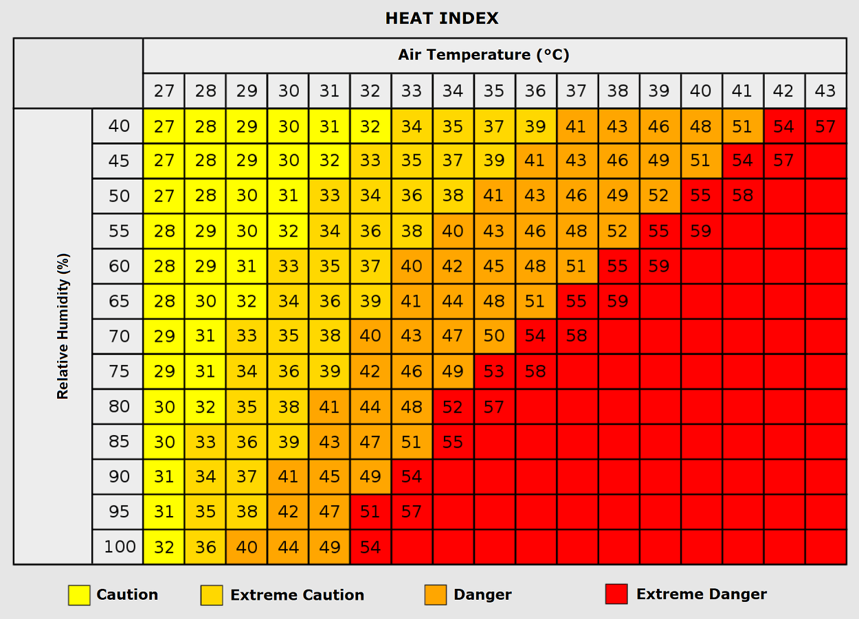
When the air mass has a temperature around +35 °C, humidity below 60 percent is much less challenging than when the humidity is very high, e.g., above 80 %. Thus, the actual feel temperature would be near 50 degrees Celsius.
Beneath these staggering meteorological statistics lies an even more grim danger. Extreme heat is a silent killer, and this current dome has already turned lethal, claiming lives across France and Spain within its first days. The danger is magnified by suffocating so-called “tropical nights” where temperatures don’t drop by 24 °C, denying the human body its vital window to cool down.
Because centralized residential air conditioning is rare across Europe, emergency rooms are bracing for an onslaught of life-threatening heat stroke. Heat waves have also been associated with increased rates of heart attacks, strokes, and respiratory illnesses.
Our additional article, Health risks during a heatwave and sweltering hot weather, provides further details on the health risks.
A historic Heat Dome expands east while further intensifying from Central Europe to the Baltics
A powerful blocking High remains parked over Europe, with a textbook locked-in weather pattern over the North Atlantic and Europe through the remainder of June. It is resulting in a historic heatwave with temperatures above 40 °C in many countries, and more heat is expected in the following days.
Throughout the final days of June, the extensive upper-level ridge will gradually expand northward and eastward, engulfing most of the European continent through early July. The core of the Heat Dome will park over Central Europe, with relief coming for Western Europe as a maritime Atlantic air mass emerges from the west.
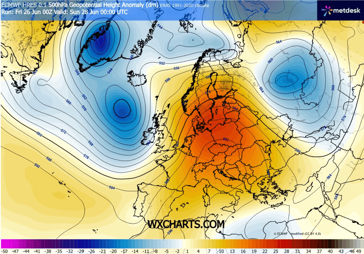
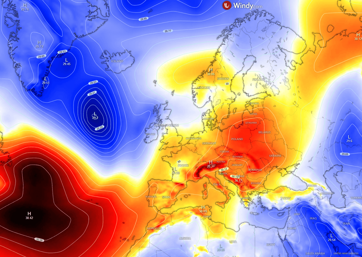
The sinking air within the heat dome keeps atmospheric pressure high beneath it, with a surface high-pressure system centered over Central and Eastern Europe.
No significant disturbances are foreseen until July arrives; the excessive heatwave will continue. The Atlantic wave will, however, bring lower pressure over the British Isles and also cooler temperatures.
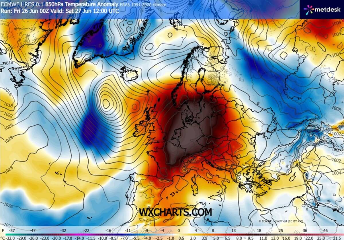
As discussed in our initial forecast earlier this week, the significantly warmer air mass is finally departing Western Europe, but it is expanding northward and eastward, with temperatures continuing to climb day by day from Central Europe to the Baltic and Eastern Europe.
It will remain a very powerful core of the Heat Dome, with nearly 16-18 °C warmer than normal temperatures in the low-mid levels. And extremely dry, with relative humidity even below 25% Rh.
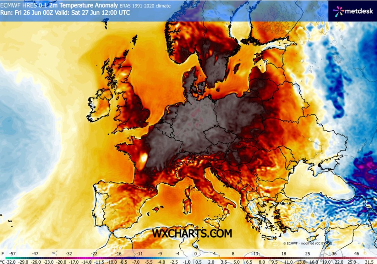
Saturday will be the final day of brutal heat over France and Benelux, as the main core gradually shifts east. So the near-surface temperatures will climb into the low 40s from eastern France across Germany to western Poland.
It will also be very hot across Denmark, the Czech Republic, and the rest of Poland on Saturday.
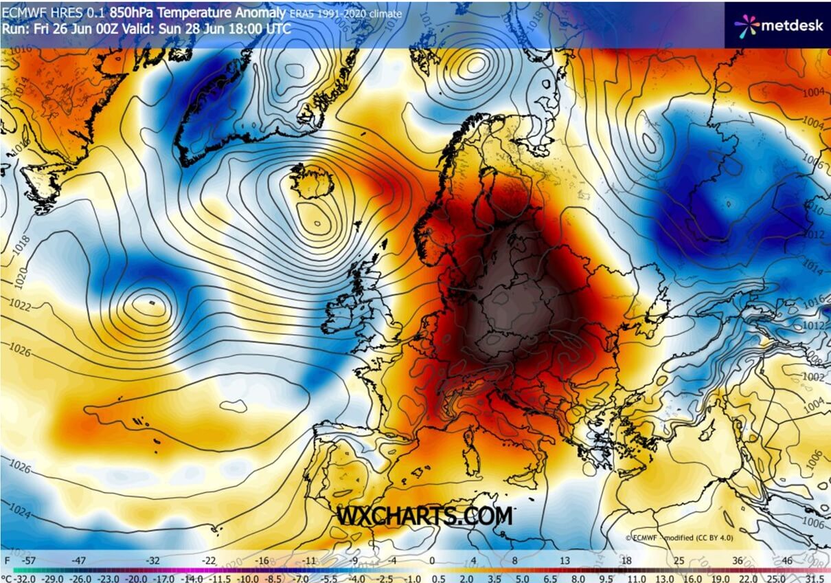
Through Sunday, the warmest and most anomalous air masses will remain over Germany, the Czech Republic, and Poland, and reach the Baltic region as well.
The midlevels will continue to show a significant anomaly, with unprecedented heat in the lowest layers of the atmosphere. The sinking air within the Heat Dome is simply baking the land into excessive heat.
Surface temperatures will increase, with daytime highs a few degrees higher than in recent days.
An extreme temperature anomaly is expected from eastern Germany to the Czech Republic and Poland on Sunday.
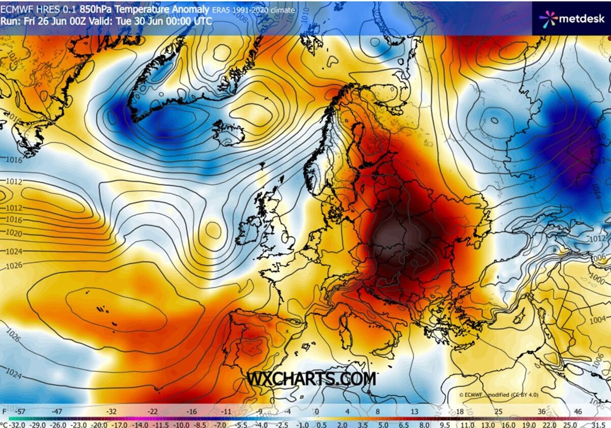
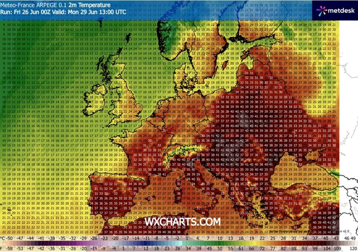
Early next week, the dome of heat will also be dragged onto the Balkan peninsula, so temperatures into the low 40s are also forecast across the central part of the peninsula.
We can also see some relief over Western Europe, but keep an eye on the Azores High, which supports above-normal temperatures that are also advecting into southwestern Europe again.
We can see how Western Europe is dominated by cooler air masses from the Atlantic, while extreme heat is driven by the peak temperature anomalies in Poland, the Czech Republic, Slovakia, Hungary, the Baltic, Belarus, Ukraine, and Romania.
It will be particularly hot across Italy and the west-central Balkans from Sunday through Tuesday as well.
The daily highs will continue to reach the upper 30s to low-40s across multiple countries, with tens of millions of people under atmospheric siege.
Temperatures reaching 40 °C on a daily basis from Germany to Poland, Italy, and the Balkans as excessive heat expands east
With the powerful ridge aloft, temperatures challenging June records and even historic, all-time high stations in several countries will continue for another five days.
Saturday – France, Germany to Poland
The excessive heat wave brings its final day for eastern France and Benelux on Saturday, with peak daytime temperatures reaching into the 39-42 °C. These temperatures will challenge the historical records of hundreds of weather stations across these regions, including all-time highs in western Germany and the Benelux.
After astonishing temperature records in Germany on Saturday, more excessive heat and higher daytime highs are expected. Some regions may reach up to 43 °C, obliterating historic records again.
Temperatures will also climb higher over the Balkans and Italy on Saturday, as the core of the heat dome expands above the region.
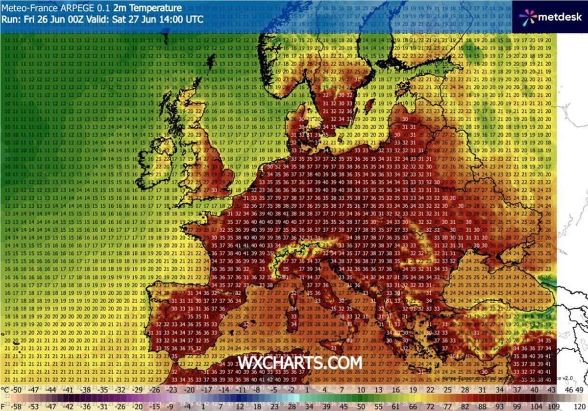
The highest temperatures will be in the upper 30s from northern Italy to the northern Balkans and across the dry valleys around the Alps.
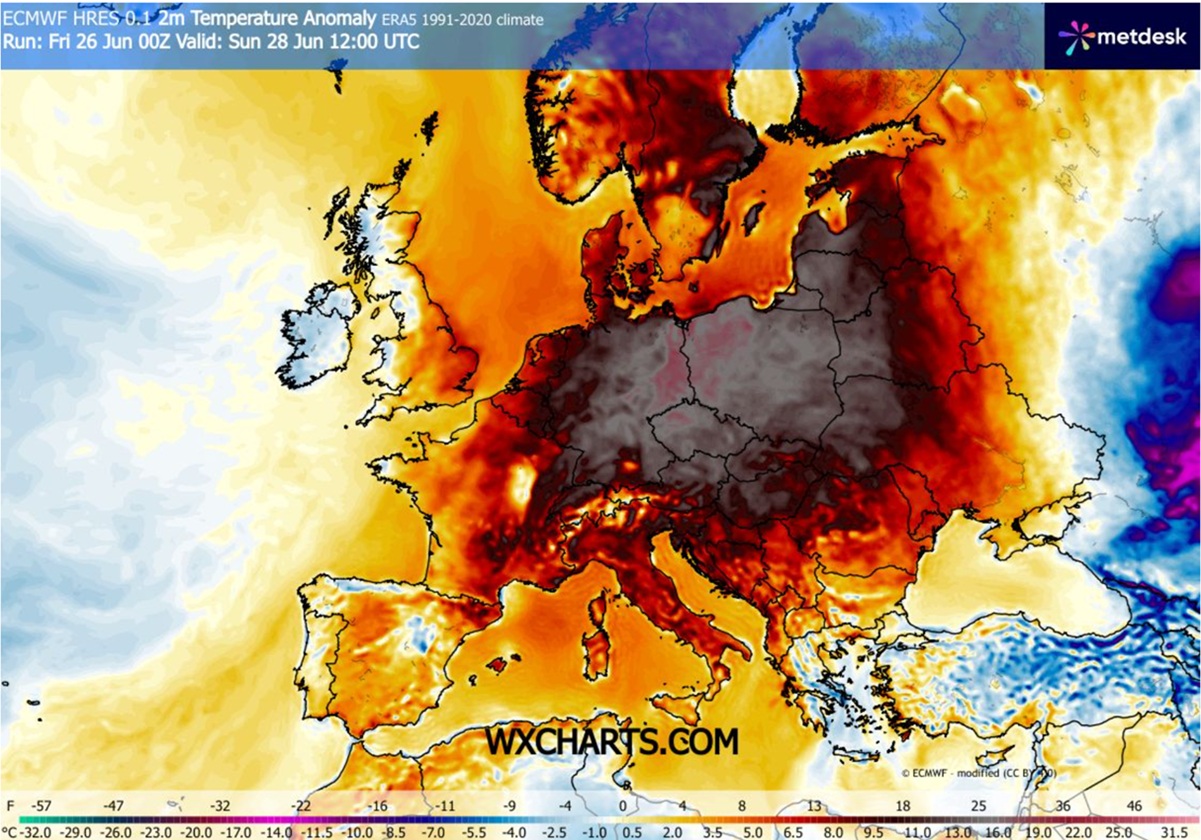
Sunday – Germany, Poland, the Baltics, Belarus, Ukraine, and the north-central Balkans
Both the global and the high-resolution ICON/ARPEGE models continue to forecast that unprecedented heat, with temperatures peaking at 42-43 °C, becomes increasingly likely across eastern Germany and western Poland on Sunday. This will obliterate all temperature records of the regions if the forecast verifies.
This is an extreme, and yet again unprecedented, heatwave for the end of June and summertime; many regions are experiencing extreme heat on a scale as never before. Therefore, numerous station records are challenged and will be broken.
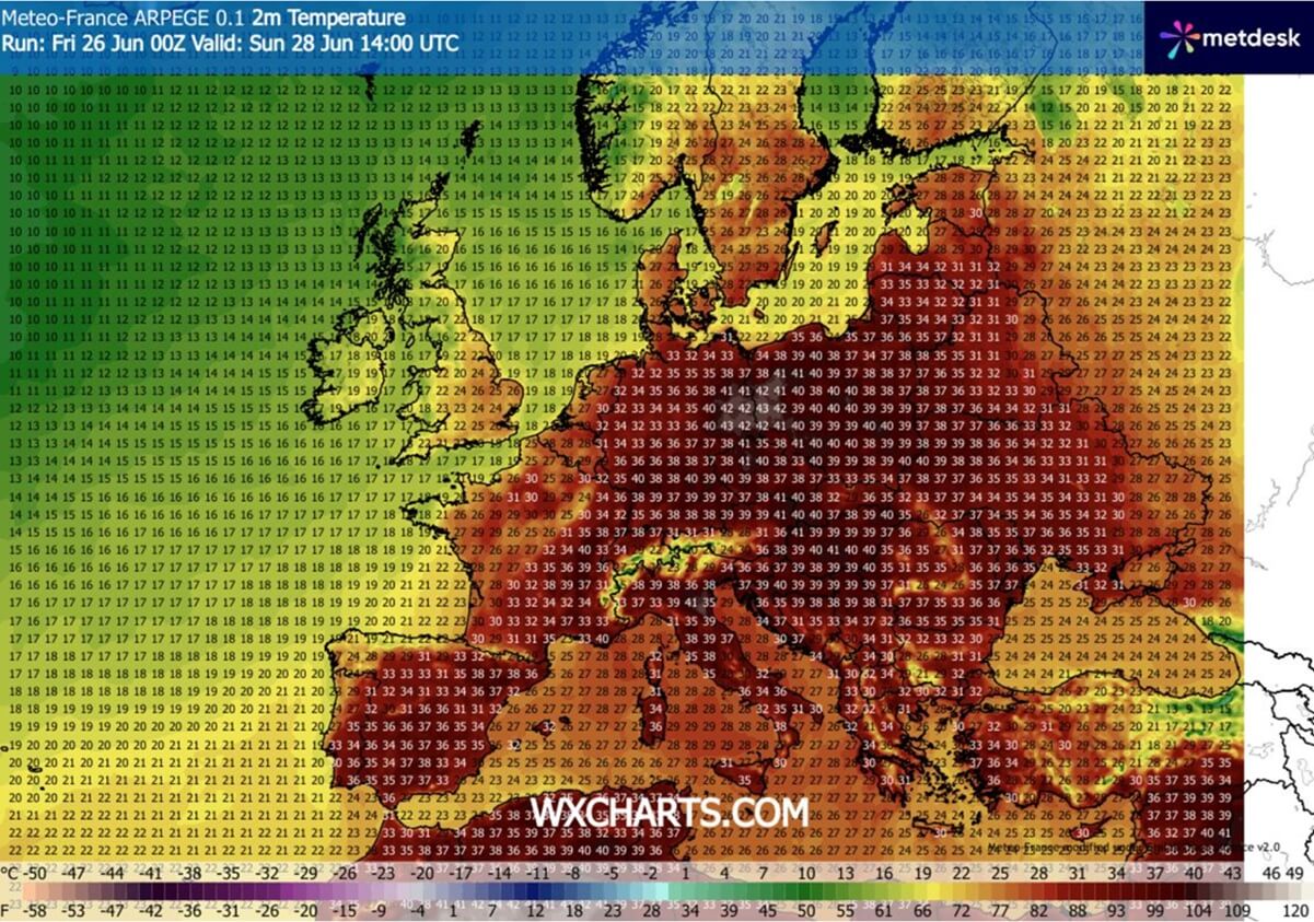
Higher temperatures will also develop further east over Belarus and Ukraine, reaching the upper 30s to 40 °C mark. As we move southward across the northern Balkans, with 40s possible from Slovakia to Hungary, and northern Italy on Sunday.
Monday, Tuesday – Eastern Europe and the Balkans, Italy
Monday and Tuesday will likely be the final impact of this brutal heatwave, with the most anomalous temperatures from Italy to the Balkans and Eastern Europe. Afternoon temperatures are expected to climb into the low 40s across many countries, potentially reaching up to 42 °C from eastern Croatia and northern Serbia across Hungary to southern Poland and western Ukraine.
Temperatures are likely to reach the low 40s also over the Romanian lowlands.
The overall weather pattern suggests that the excessive heatwave effect is likely to decay later next week, as July arrives. But until then, the accumulating heat will be long-lasting, worsening drought conditions and gradually increasing the risk of wildfires. The soil is already pretty dry in many areas.
We are closely monitoring the ongoing development of this truly historic Heat Dome and an associated excessive heatwave for Europe. If severe weather redevelops with the troughs next week, we will update the forecasts accordingly as the situation evolves.
Stay tuned for the updates.
Windy, and WXcharts provided images used in this article.
See also: