The final days of June in Europe will remain dominated by an extensive and persistent Heat Dome aloft. After days of significant heat this week, another even more intense heatwave is forecast to expand into western Europe, pushing temperatures up to +43 °C over France and +45 °C in Portugal and Spain early next week. Significant heat will expand into central Europe by mid-week and continue into early July 2025. Drought conditions are worsening, and wildfire threats are gradually increasing.
** This will be the most intense heatwave of the summer season 2025 so far for many countries across western and central Europe. **
Over the next 10 days, peak temperatures will be 41-43 °C over France, up to 35 °C over southern England, 45 °C over Portugal and Spain, upper 30s over Germany, and around 38-41 °C over parts of Italy and the central Balkans.
A major Heat Dome that has built up over a large part of Europe since mid-June remains strong and does not show any signs of weakening until at least early July 2025. Stable hot weather significantly increased temperatures, leading to the first 40 °C reaching over France and the central Balkans, contributing to numerous highest maximum station records for June.
Combined with low humidity, the ongoing drought conditions in many parts of Europe are also rapidly worsening, thus increasing the threat of wildfires.
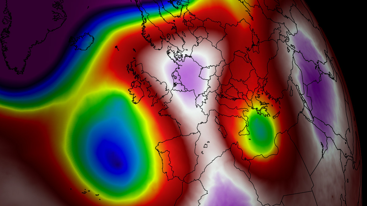
The following animation provides a quick overview of the intense heatwave that re-developed in western and central Europe during the final days of June and extended into early July 2025.
One can notice how a large, dominant blocking High will dominate a large part of Europe, causing extreme heat to develop, while the northern and eastern parts of the continent remain in normal or cooler weather conditions.
More excessive heat will spread from the Iberian Peninsula into France by early next week, becoming the most intense of the summer season so far. Spain, Portugal, and France will experience temperatures from 41 to 45 °C.
So, the upcoming re-developing heatwave is the result of an unusually persistent and intense heat dome feature aloft. Let’s examine this large-scale feature and why understanding its behavior is essential.
What is a Heat Dome?
When significant and historic record-breaking heatwaves occurred in Europe, the United States, and Canada in the past, the Heat Dome was a contributing factor. The heat dome is usually the dominant feature of summer weather patterns on both continents.
We refer to this phenomenon as a heat dome when extremely high temperatures develop. Here’s how it works and why understanding it on a broader scale is essential.
The upper-level ridge pattern, or very warm air mass in the higher altitudes, also known as the Upper High (or blocking High), usually forms the heat dome. This weather pattern brings high and sometimes record-breaking temperatures to the region underneath.
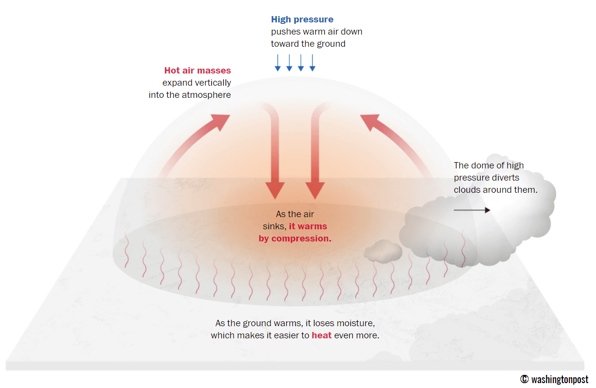
This term is used when a broad area of high-pressure air parks over a large portion of the continent. If the event is remarkably stable and extreme, it usually lasts several days or weeks.
The heat dome works like a lid on a pot. The extensive dome traps warm air at all levels underneath, with layers sinking toward the ground. Therefore, the air mass becomes anomalously warm at the lowest elevations and extremely hot near the surface.
How does a heat dome impact the life underneath?
Excessive heat in heat domes can significantly impact human health and be dangerous to particularly vulnerable populations, such as elderly individuals, children, and those with pre-existing health conditions that can be worsened by extreme heat.
Due to prolonged exposure to high temperatures, construction workers, farmers, and agricultural workers who work outdoors for long hours are at increased risk of heat-related illnesses. People living in poverty are also more susceptible to the fatalities of heat domes, as their houses are often built with heat-trapping surfaces such as concrete and asbestos.
Heat exhaustion occurs upon exposure to high temperatures for extended periods. It leads to dehydration, dizziness, and, in more severe cases, heat exhaustion can progress to heat stroke.
High relative humidity during a heatwave can also significantly affect the body. For this reason, we use a Heat Index to represent the natural feel of scorching hot temperatures and high humidity. These graphics illustrate the natural relationship between temperature and humidity.
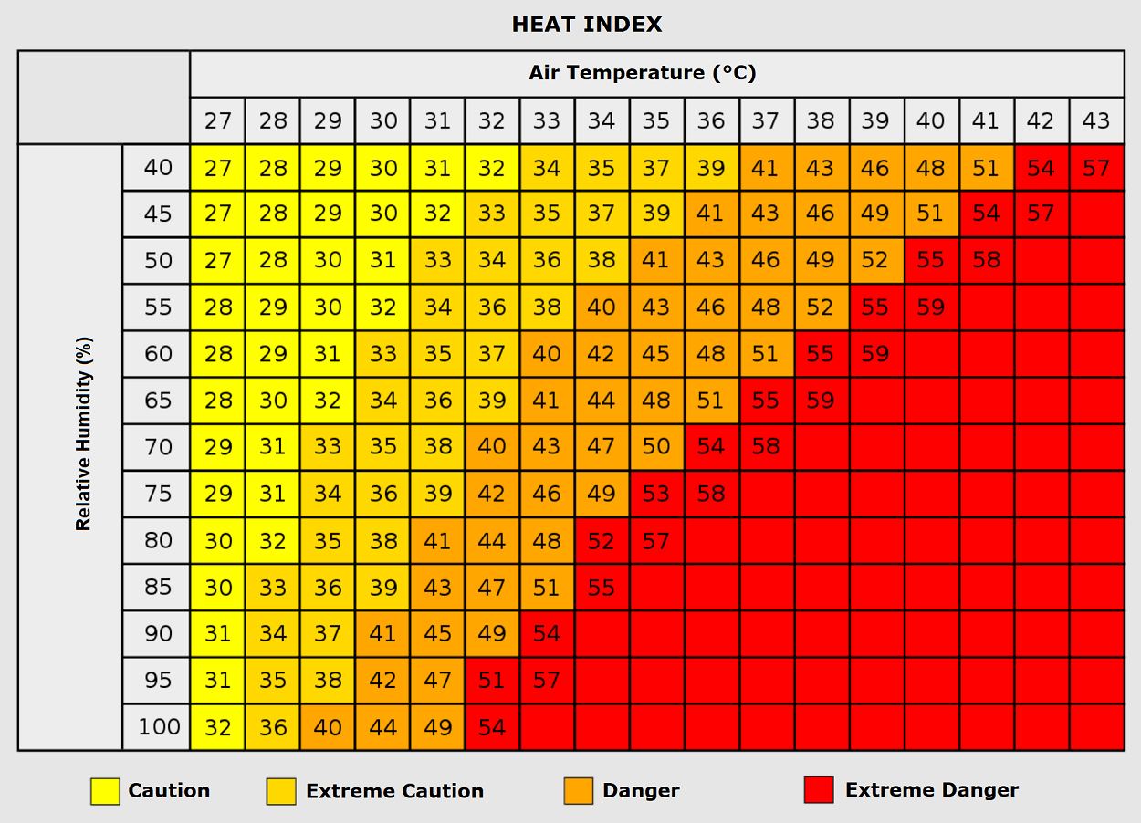
When the air mass has a temperature around +35 °C, humidity below 60 percent is much less challenging than when the humidity is very high, e.g., above 80 %. Thus, the actual feel temperature would be near 50 degrees Celsius.
Heat waves have also been associated with increased rates of heart attacks, strokes, and respiratory illnesses.
Our additional article, “Health risks during a heatwave and sweltering hot weather,” provides further details on the health risks.
The Heat Dome persists over the continent, igniting another intense heat wave in Western Europe
The heat dome parked over a large part of Europe this month shows no signs of weakening anytime soon. Even worse, general trends support the idea that it will extend for another 7-10 days into early July 2025.
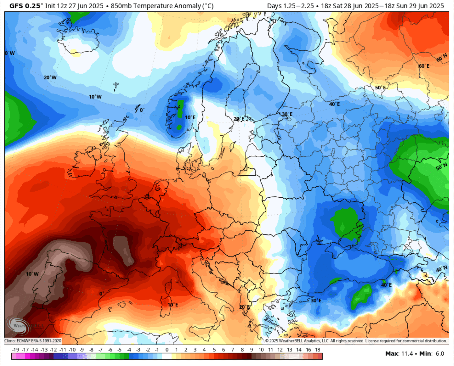
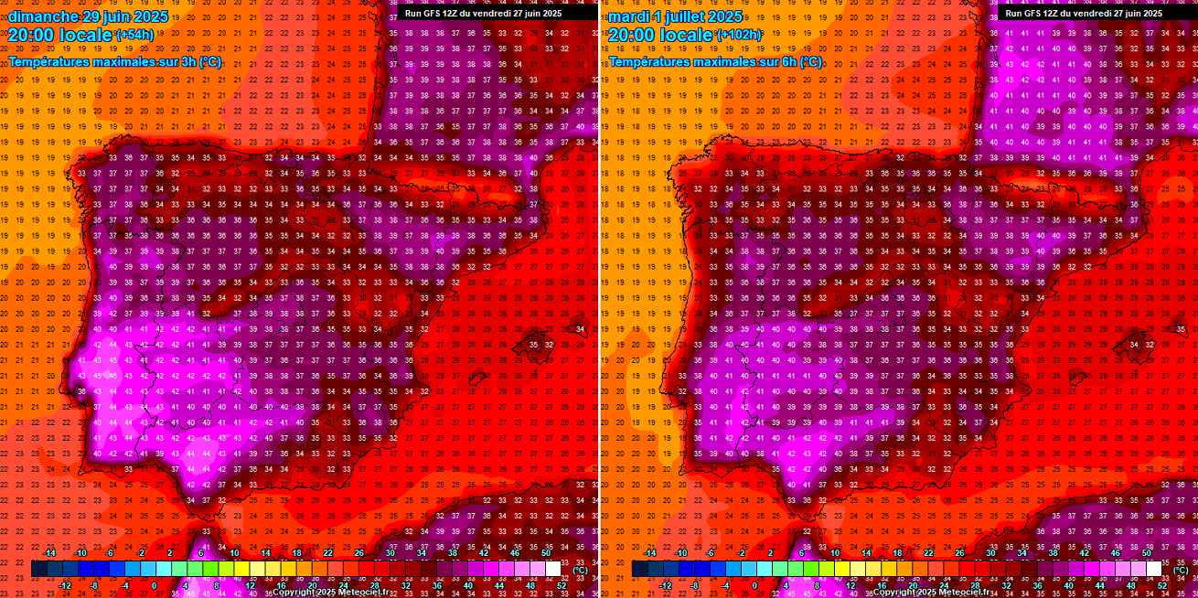
This weekend, the dome’s center will strengthen over western Europe, maintaining extreme heat over Spain and Portugal. After Sunday, a heatwave will intensify in France. The pattern on the following chart hints at the Omega blocking ridge, having a dome in the middle and upper waves/lows on each side.
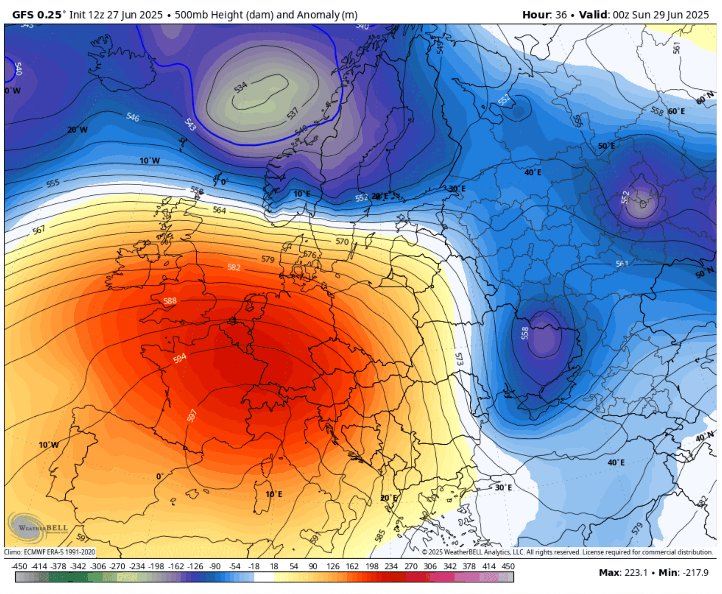
So, the strengthening of the heat dome and a large wave over the Atlantic releases another significantly warm air mass plume into southwestern and western Europe. This Saturday and Sunday, the most intense heat will be across the western part of Iberia.
So, the extremely hot air will remain in southern and western Spain and most of Portugal. By Sunday, temperatures will also significantly increase in France.
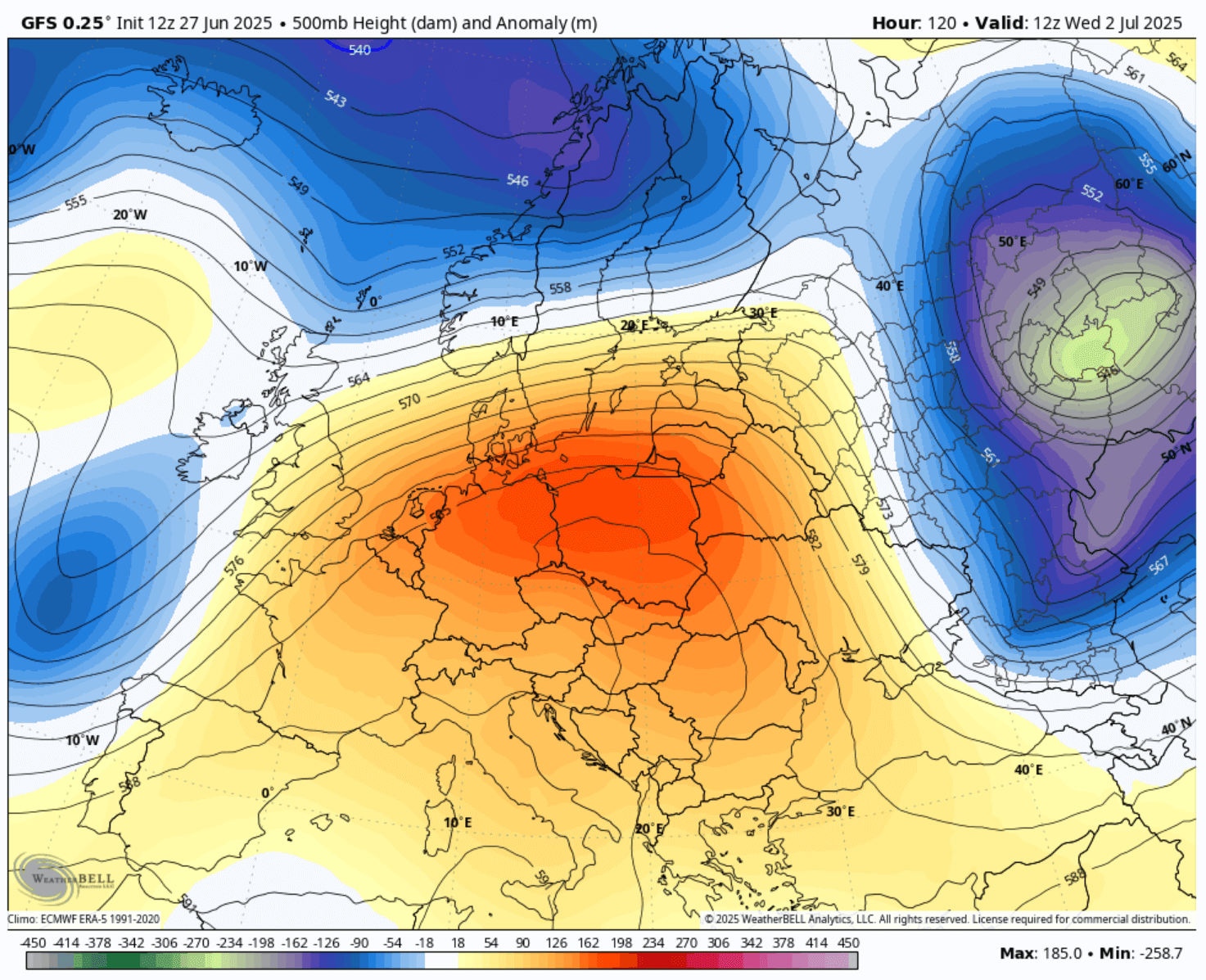
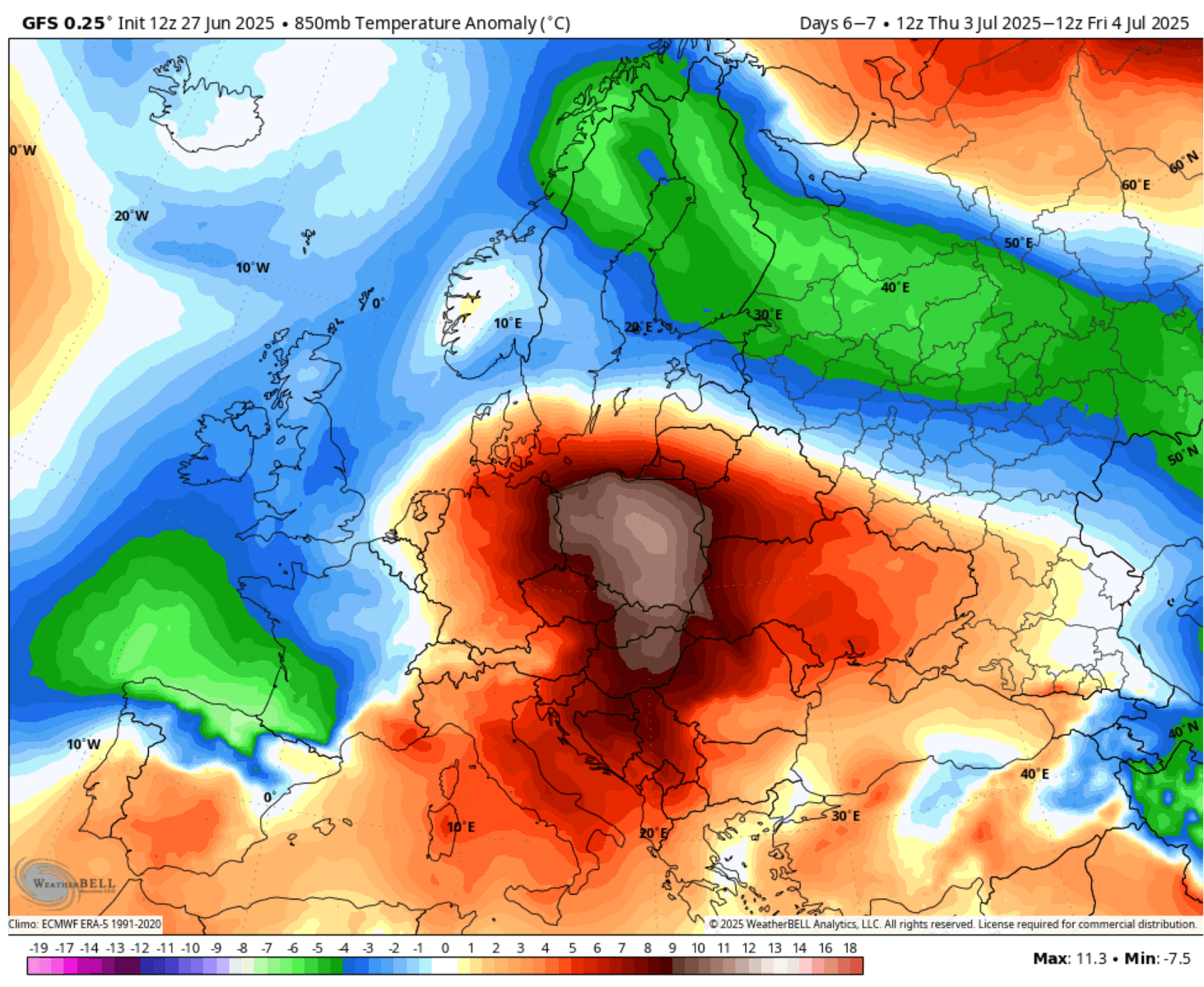
Then, the heat will blow up by early next week. The following chart for Tuesday reveals an extreme temperature anomaly: more than 15 °C warmer air mass than normal over France, Benelux, and western Germany.
While these temperatures are approximately 1200m above sea level (850 mbar geopotential chart), it hints that strongly anomalous temperatures also translate into the lowlands. Dry air mass and drought conditions in many areas also result in extreme heat beneath.
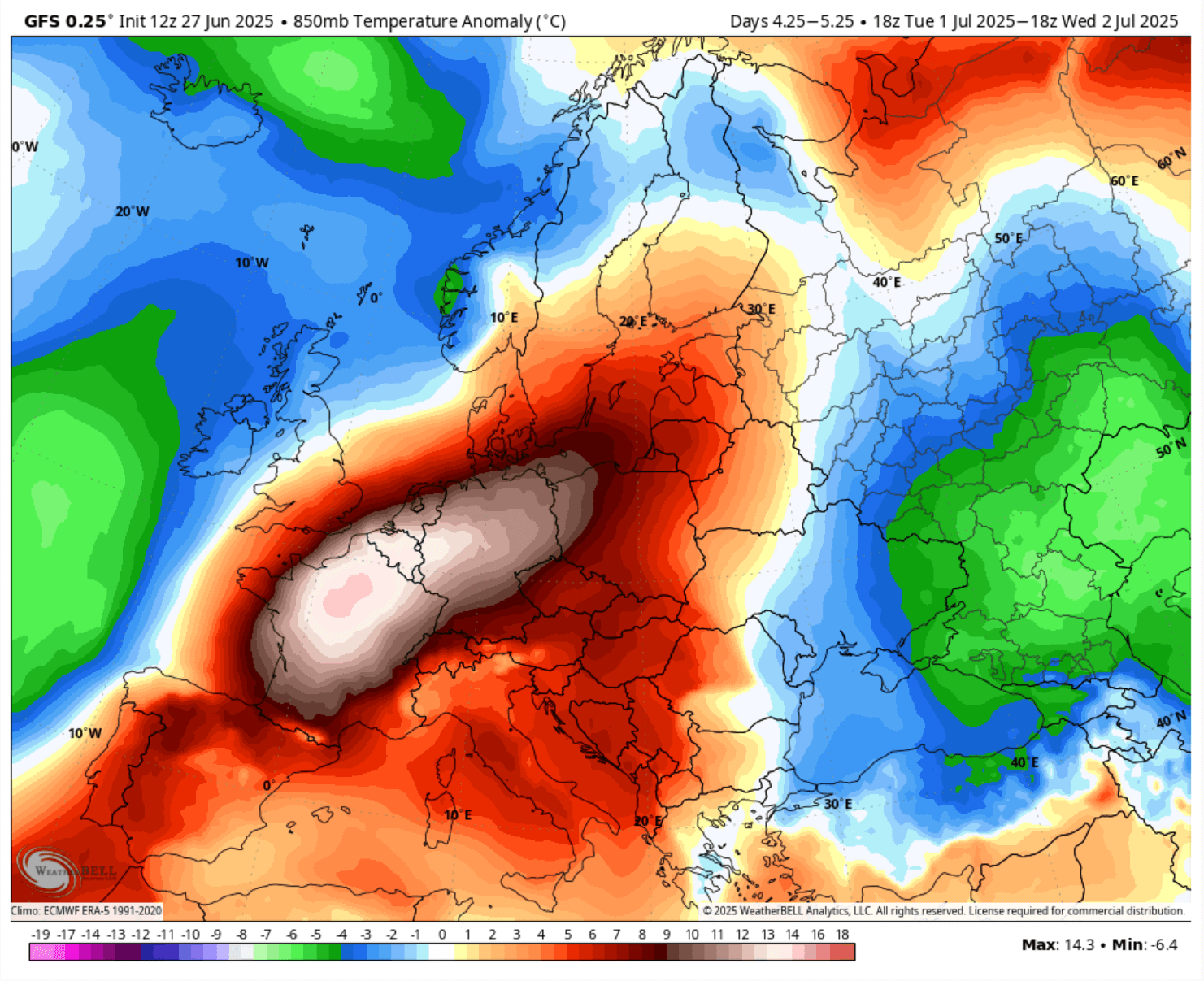
We can also see how cooler airmass persists in the far East, while the heat dome keeps significantly warmer air mass in the rest of Europe.
Extreme heat develops, Iberia up to 45 °C, France 41-43 °C early next week
As mentioned above, with a heat dome as the dominant feature these weeks, the effect of subsiding air mass warms and dries up the lower levels as the air mass sinks towards the ground.
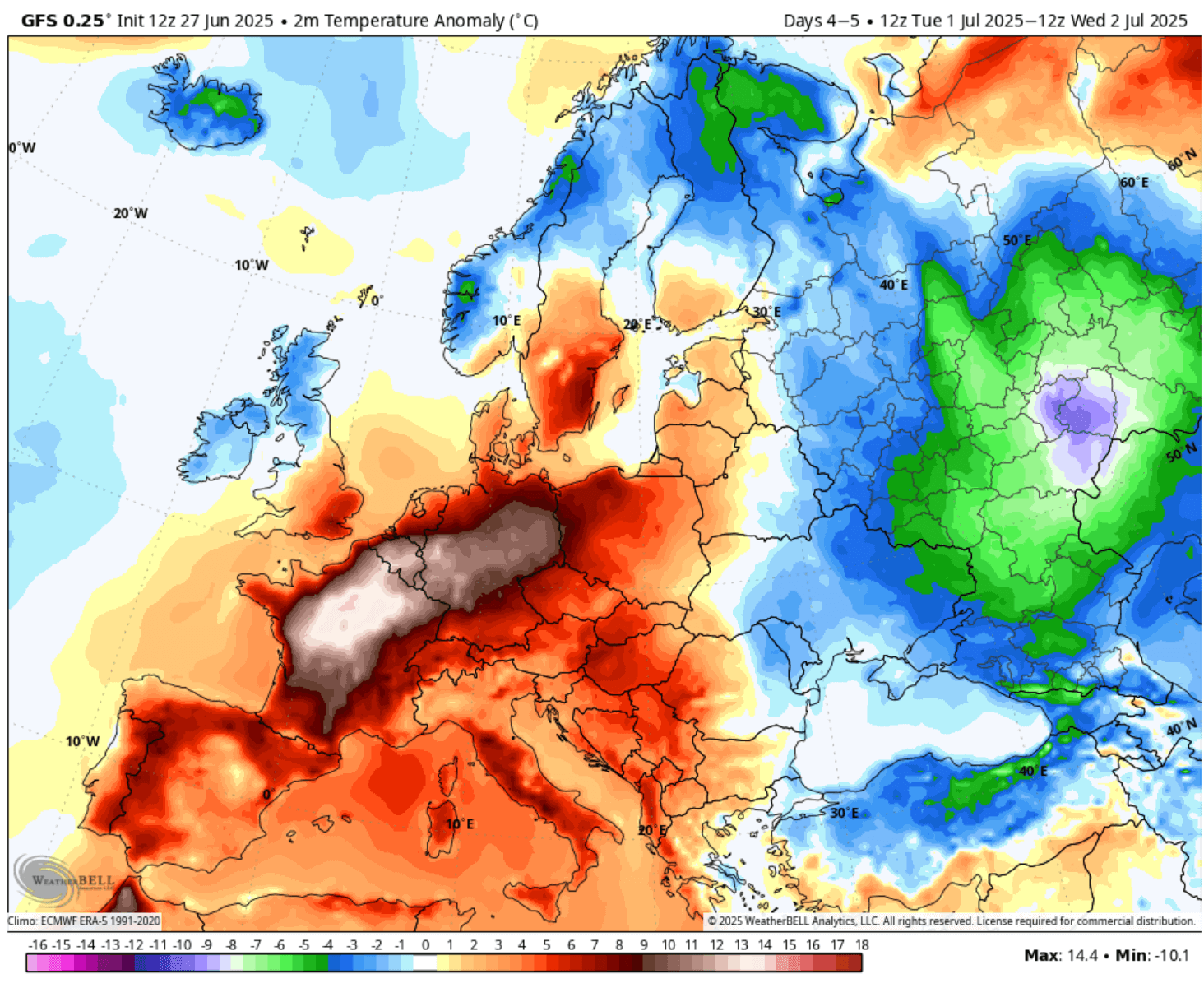
Tuesday’s following 2m temperature anomaly chart indicates how extreme heat will develop. Large parts of France, Benelux, and western and north-central Germany will experience the highest and most anomalous temperatures.
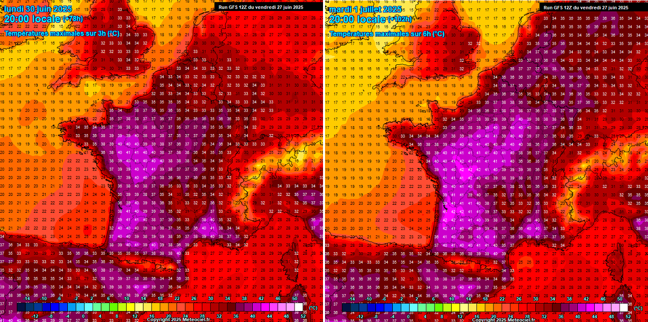
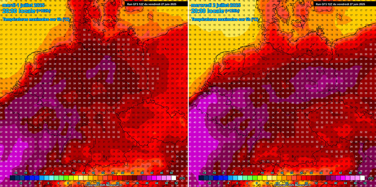
The temperatures this weekend over France will gradually increase by Sunday, but significantly ramp up by Monday, especially Tuesday. Monday should bring temperatures across south and western France into 38 to 41 °C.
Tuesday goes into extremes. Parked underneath an intense heat dome aloft, the heatwave’s peak develops towards the ground. A large part of France, excluding the proximity of the English Channel, will have temperatures from 38 to 42 °C, possibly even close to 43 °C in some areas.
The heat will be the most excessive across the western portions of the country.
The Iberian Peninsula will easily keep the temperatures in the low 40s on each of the following days. The air mass is so significantly hot that extreme heat is maintained with no disturbances nearby to disturb the power of the Sun.
Sunday will most likely be the hottest day of the year over southern Spain and Portugal, with models hinting at 44-46 °C in some valleys. Although the region is well known for extreme heat, reaching mid-40s is still far beyond the long-term average daily maximum for the end of June.
Monday and Tuesday will see slightly lower temperatures in the 40-43 °C range. Temperatures will also reach around 40 °C in northern Spain these days, specifically in the valley known as the Catalan Central Depression in the western Catalonia region.
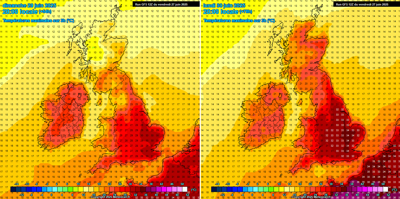
Ireland and especially the southern UK will not avoid the significant heat either. Temperatures over southern England will push back into the low 30s on Sunday.
Meanwhile, Monday charts indicate that temperatures will be even more extreme, pushing the peak afternoon temperatures close to +35 °C across southeast England, including London, where maximum temperatures will reach 33-35 °C.
Tuesday should bring lower temperatures, while Ireland and Scotland remain in the low to mid-20s all the time.
The Paris, France (left) and the Warsaw, Poland (right) meteogram charts are attached below.
We can see that the heatwave peak over France will be around the 2nd of July (Wednesday), while Poland will see the peak a day after (Thursday).
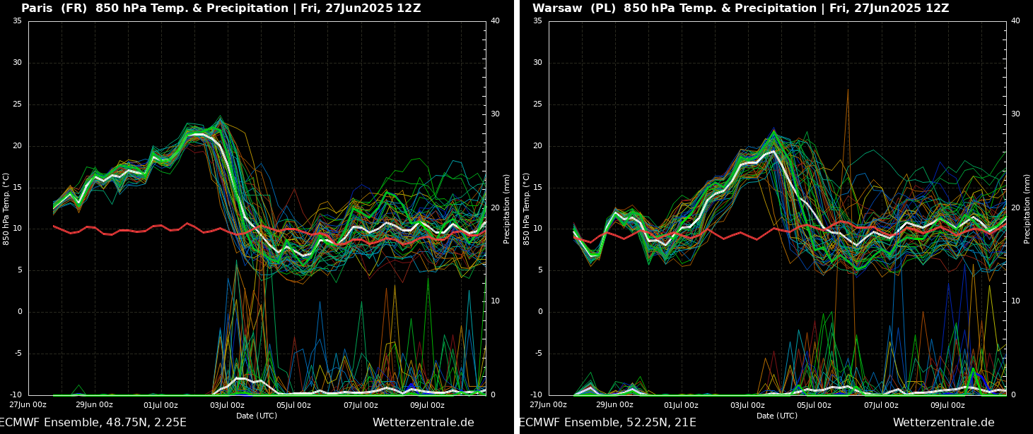
Both charts also hint at the potential for a good refreshment late next week, with a sharp temperature drop, especially in western Europe. This could mean the heat dome will lose its breath with a frontal wave emerging from the North Atlantic.
Heatwave expands and intensifies into central Europe through early July 2025
By mid-next week, the Omega blocking pattern and the associated heat dome will gradually expand east, being placed over central Europe on Wednesday. This means the hottest air mass will also spread east.
The warmest and most anomalous air mass from Wednesday through Friday will be over central and partly eastern Europe and the Balkan peninsula. Thus, the region will experience extreme heat again, with the lowest levels of the atmosphere around 12-14 °C above normal.
We can also see the intrusion of a much colder maritime air mass from the Bay of Biscay into northern Iberia and France on Thursday, which is aligned with what we have noted on the Meteogram chart above. Notice a strong temperature contrast, indicating a potential for severe weather in those days.
So, the mid-week days will expand the extreme heat further east, bringing temperatures into the mid- to upper-30s over western, north, and central Germany and Benelux on Tuesday and Wednesday.
Weather models also hint that Wednesday could push temperatures into the 40 °C range over southern Benelux, especially Belgium and Luxembourg. The hottest air mass in Germany will be across the northeast parts, with peaks reaching 38-39 °C on Wednesday.
Further south, Monday through Thursday, we will see the highest temperatures again over Italy and the Balkan peninsula. There is an increasing potential for temperatures to return to the upper 30s over central Italy and the Pannonian plain.
Mid-week days could touch the 40 °C mark again in eastern Croatia and parts of Serbia.
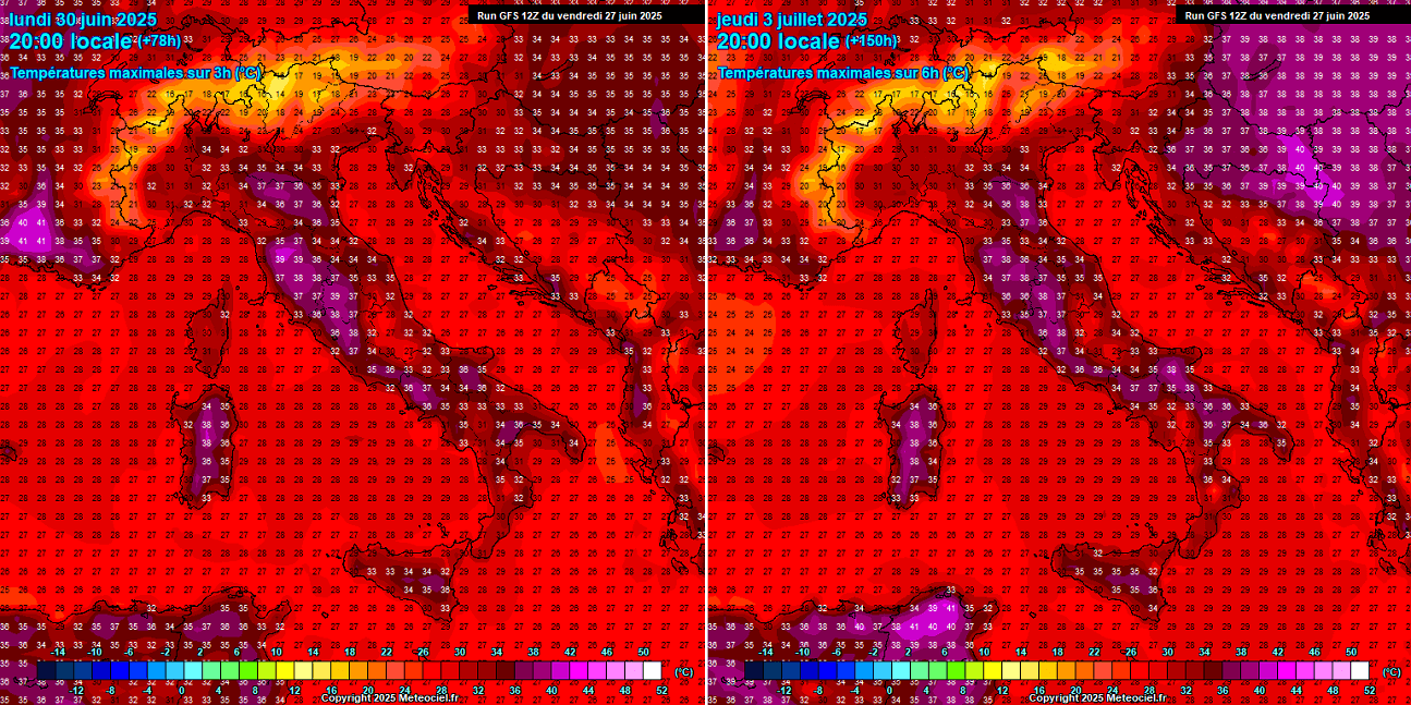
Elsewhere, a heatwave will remain, with temperatures in the mid- to upper 30s throughout next week.
Long-lasting and persistent heatwaves are rapidly worsening drought conditions over Europe
As mentioned earlier, the long-lasting, persistent, and intense heat dome with prolonged heat waves is quickly drying out the European continent. So, drought conditions are increasingly worsening. However, this year, drought conditions have developed from late winter through spring following the lack of precipitation.
The sum of these pre-existing conditions is a rapidly worsening drought in many parts of Europe. The chart below shows that the top 1 meter of soil in the European mainland is extremely dry this summer.
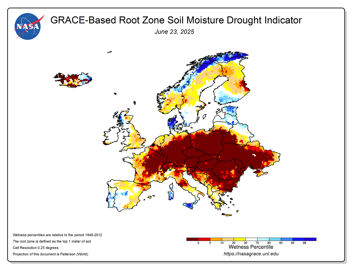
Although there were some frontal systems with storms and rain events in recent weeks, they were not close to being enough to stop the developing drought. The overheating is just too significant, and the soil moisture is drying out.
This is also rapidly increasing wildfire conditions; thus, fire danger is closing in and becoming a serious issue in the following weeks.
We advise everyone to be cautious when using an open fire while camping during holidays. Monitor the local countries that already have alerts on this matter, and some of them are also forbidding the use of fire due to the extreme drought underway.
Although the heatwave will likely persist until next weekend for many, the weather pattern in the West could become more dynamic and lead to severe weather periods again.
We will continue to monitor the evolution of the weather pattern and update the forecasts accordingly. Stay tuned.
Wxcharts, WeatherBell, and Wetterzentrale provided images for use in this article.