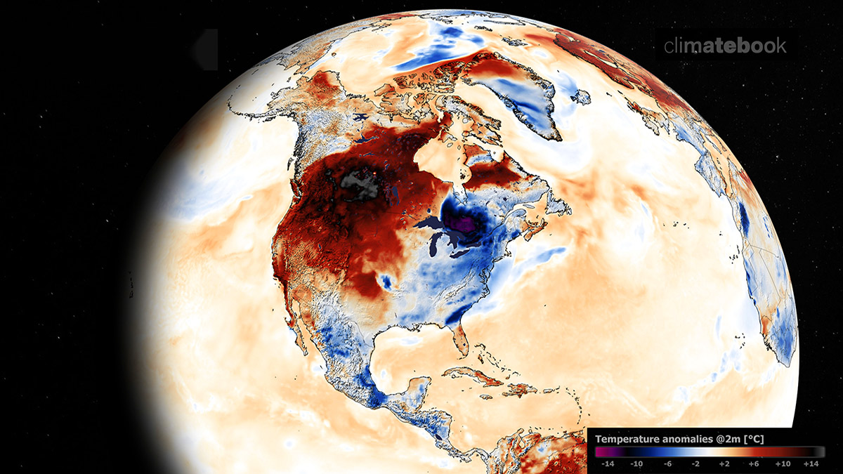
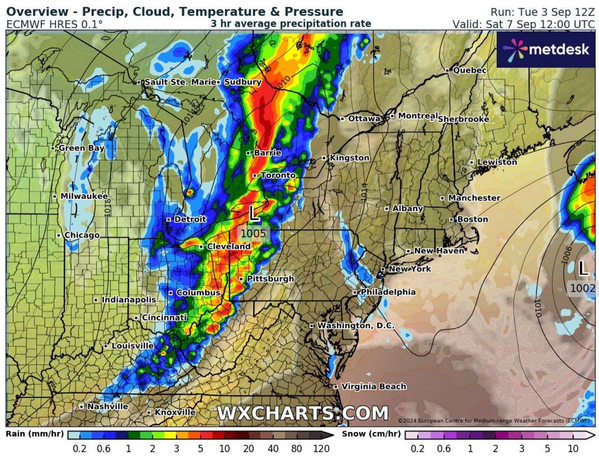
September starts with nice and dry fall weather, but more dramatic weather changes are shaping up on the horizon late this week and over the weekend. A frontal system emerging from the Midwest will cross the Great Lakes and the Northeast by Saturday, resulting in stormy weather and local heavy rain. Behind the front, significantly colder air from central Canada spreads deep south across the eastern third of the U.S.
The first change comes Thursday night into Friday with a strengthening upper wave across the Midwest, with an associated surface frontal system moving into the Great Lakes and Ontario, Canada. On Saturday, the surface low deepens, and heavy rains will intensify. The surface front will move across the Northeast U.S. and exit the Atlantic coast by Sunday.

A much colder air mass will spread behind this system, making it the coldest intrusion of the fall season 2024 so far.
These first days of the meteorological fall of 2024 bring mostly warmer-than-normal weather nationwide.
This week has been particularly warm across the South, Southeast, and Great Plains. On Tuesday, a scorching heatwave remained across the desert Southwest U.S., with temperatures peaking at 110 °F.

Hot weather in the upper 90s and low 100s across the Dakotas will gradually be swept away Wednesday night into Thursday as the cold front emerges from the north. Some severe weather, with gusty winds and large hail, will also be possible. The frontal system will continue across the Midwest and Great Lakes through Friday and the Northeast for the weekend.
A deep upper wave emerges over the Great Lakes and the Northeast U.S. late this week
The general weather picture across southern Canada and the United States this early September indicates a stable weather pattern that gradually gets interrupted by a quite deep upper wave from central Canada towards the Great Lakes after Thursday.
This will create a strong contrast between blocking High on the West and deep low on the East.

As the weekend arrives, the upper wave will mature into a large low, with a well-defined frontal system at the surface. Thus, it will bring rainy and windy weather for a few days. The depth of the low will also allow a much colder air mass to push far south across the eastern half of the U.S., shutting down the warm weather for some time and bringing cold fall season days.
The temperature contrast between western Canada, sitting underneath the heat dome, and the deep core over the Upper Midwest and Great Lakes will be significant. Breezy northerlies will also bring the real feel even lower.

It will be quite a temperature change against the conditions early this week.
Friday will bring the coldest weather for the Dakotas and the Upper Midwest. On Saturday, the cold front will gradually spread behind it towards the Great Lakes and Ohio Valley. On Sunday, colder temperatures will spread further south and east, reaching the Northeast U.S., the lower Mississippi Valley, and at least the northern portions of the Southeast United States.
Colder air will also reach the Gulf Coast on Sunday, with a few degrees below average from Texas to the Florida Panhandle.

With the frontal system gradually vanishing by early next week over the Northeast U.S. and Mid-Atlantic, temperatures will warm up again across the Midwest and Great Lakes. However, colder air will remain across the southern states through early days next week before conditions warm up into near-normal September temperatures again.
Frontal system to interrupt Great Lakes and Northeast weekend with rainy and windy weather
The ongoing hot weather across the Great Plains will vanish Wednesday night as the frontal wave approaches from the Canadian prairies. As the front progresses towards the east, conditions will deteriorate, and storms are forecast to bring heavy rain along the moving front.
While the lack of instability is there for significant storms, some could become severe and bring heavy rain, gusty winds, and hail. The heaviest rain and storms are forecasted on Saturday when the surface is low, and the front strengthens across the central Great Lakes into Ontario, Canada, and Ohio Valley while moving east.

The heaviest rainfall will likely accumulate a couple of inches of rain from northern Indiana across the Lakes to Ontario, Canada; locally, 5+ inches will be possible until Sunday.
Local flash floods will be possible as torrential rainfall with the strongest storms is also possible.

Once the front moves east, the northerlies in its wake will cool down the air mass for the Dakotas on Thursday. They will then reach the Upper Midwest and western Great Lakes on Friday and continue east and south on Saturday.
The video animation below hints at the progress of the frontal system late this week.
Notice the associated cold air mass intrusion that will follow it over the weekend into early next week.
Significantly colder air mass spreads across the United States
The temperatures following the cold front will be the lowest this fall season, pushing into the upper-30s across Minnesota and Wisconsin and low to mid-40s over the weekend around the Lakes and Ohio Valley.
The temperature drop will progress from west to east, starting across the Dakotas on Thursday and progressing across the Midwest and western Lakes on Friday. On Saturday, It will reach east towards the Northeast U.S. and south to mid-Mississippi and Ohio Valleys.

The coldest airmass on Friday and Saturday mornings will be across Dakotas and the Upper Midwest, with nighttime lows into the upper 30s to mid-40s.
The mid-50s are forecast across the Central Plains and Midwest to the Great Lakes on Saturday, and it will become colder the night after on Sunday and Monday.

The cold wave above the Great Lakes and Northeast will mature on Sunday, so the coldest air mass at the surface will continue spreading east and south from Sunday into early next week. Thus, the coldest mornings there will be on Monday and Tuesday.
On Monday, the Upper Midwest, Great Lakes, Ohio Valley, Northeast U.S., and Mid-Atlantic will push morning lows down to the upper 40s and low 50s.

Further west, temperatures will already become warmer after Monday as the upper cold wave vanishes across the Northeast, and conditions will return to normal for most of the U.S. in mid-September.
Wxcharts and Pivotalweather provided images for this article.
See also:
Winter 2024/2025 First Snowfall Predictions: Under the Jet Stream shift of the cold La Niña