The 8.2 magnitude earthquake struck off the Alaskan coast, about 55 miles (90 km) southeast of the city of Perryville, Alaska. Coastal areas of southern Alaska are under tsunami warnings.
The earthquake, now confirmed as an 8.2 magnitude, has been recorded around 10:15 p.m. local Alaskan time (06:15 UTC), according to the United States Geological Survey (USGS). Its depth was 20 miles (32 km) at a distance of about 55 miles (90 km), south of the Alaska Peninsula.
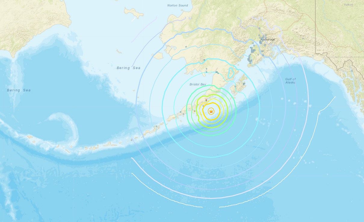
Tsunami alerts have been issued for southern parts of Alaska, the volcanic peninsula itself, and also for the Pacific coastal areas from the Hinchinbrook entrance to the Unimak pass.
Tsunami Warning in effect for:
- SOUTH ALASKA AND THE ALASKA PENINSULA, Pacific coasts from Hinchinbrook Entrance, Alaska (90 miles E of Seward) to Unimak Pass, Alaska (80 miles NE of Unalaska)
- ALEUTIAN ISLANDS, Unimak Pass, Alaska (80 miles NE of Unalaska) to Samalga Pass, Alaska (30 miles SW of Nikolski)
Tsunami Advisory in Effect for:
- SOUTHEAST ALASKA, The inner and outer coast from Cape Decision, Alaska (85 miles SE of Sitka) to Cape Fairweather, Alaska (80 miles SE of Yakutat)
- SOUTH ALASKA AND THE ALASKA PENINSULA, Pacific coasts from Cape Fairweather, Alaska (80 miles SE of Yakutat) to Hinchinbrook Entrance, Alaska (90 miles E of Seward)
- ALEUTIAN ISLANDS, Samalga Pass, Alaska (30 miles SW of Nikolski) to Amchitka Pass, Alaska (125 miles W of Adak) including the Pribilof Islands

Follow the latest alert updates at: www.tsunami.org
There have been at least three strong aftershocks, including the quakes with the magnitudes 6.2, 5.9, and 5.6, following 15-20 min after the main earthquake.
The epicenter was about 800 km (500 miles) away from Anchorage, Alaska’s biggest city. There was no tsunami threat to Anchorage.

The Pacific Tsunami Warning Center (PTWC) said it had canceled warnings of possible tsunami threats issued to Hawaii and the U.S. Pacific territory of Guam.
There have been at least 13 earthquakes recorded around the world in the past 24 hours.

The recent strongest earthquakes are the following:
- M8.1 at Kermadec Islands, New Zealand (March 4th, 2021)
- M7.8 in Alaska Peninsula, United States (July 22nd, 2020)
- M8.2 in Fiji (August 19th, 2018)
- M8.0 in Peru, South America (May 26th, 2019)
Today’s earthquake southeast of Perryville, Alaska, occurred as the result of thrust faulting on or near the subduction zone interface between the Pacific and North America plates. The preliminary focal mechanism solution indicates rupture occurred on a fault dipping either shallowly to the northwest, or steeply to the southeast.
The so-called Aleutian arc extends approximately 3.000 km from the Gulf of Alaska in the east to the Kamchatka Peninsula in the west and is a favorable area for numerous earthquakes in the past, including very powerful ones in the last century. The map below is showing this arc with all the earthquakes since 1900.
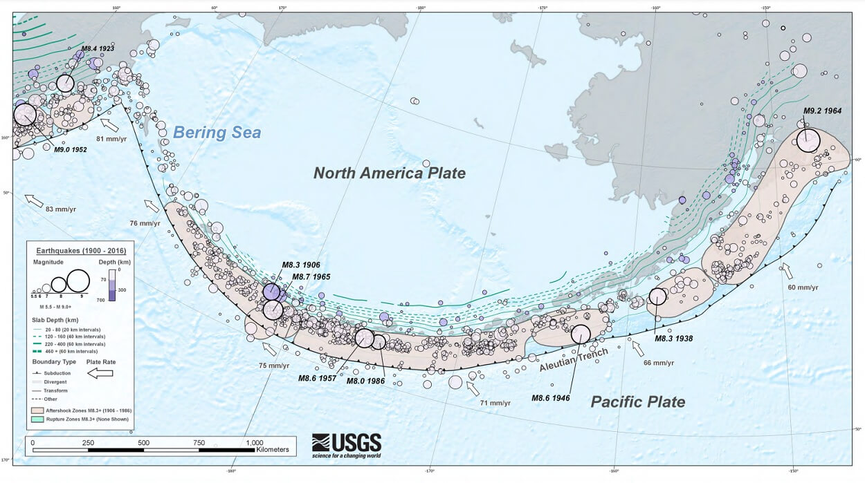
The location, mechanism, and depth – and the large size of the event – are all consistent with slip occurring on the subduction zone interface between the two plates. At the location of this event, the Pacific plate converges with North America to the northwest at a rate of about 64 mm/yr, subducting at the Alaska-Aleutians trench about 125 km to the southeast of the earthquake.
Note, that large earthquakes are common in the Alaska-Aleutian subduction zone. Since 1900, 8 other earthquakes of magnitude 7.0 and larger have occurred within 250 km of the today’s event. Here are the major quake events in the nearly areas:
- M7.8 on July 22nd, 2020
- M7.6 on October 19th, 2020
- M8.2 also occurred on November 10th, 1938
All of these past earthquakes occurred within the 200 km radius around today’s M8.2 earthquake.

Above: Potential tsunami travel times across the Pacific Ocean.
The Alaska-Aleutian Trench also hosted the second-largest earthquake recorded by modern seismic instrumentation. On March 27th, 1964, a magnitude 9.2 earthquake, which ruptured to within about 250 km of the July 29th event, at the eastern end of the 1938 rupture area.
The 1938 event produced a small tsunami that was recorded both locally and in Hilo, Hawaii. The remote location of the earthquake resulted in little impact on people and infrastructure.
*** This is breaking news and details will be adjusted as more information is available.
SEE ALSO:
A powerful M8.1 quake prompts Tsunami warning for New Zealand and Tsunami Watch for Hawaii, March 4th, 2021
Powerful M7.8 quake struck Alaska in the morning of July 22nd, 2020