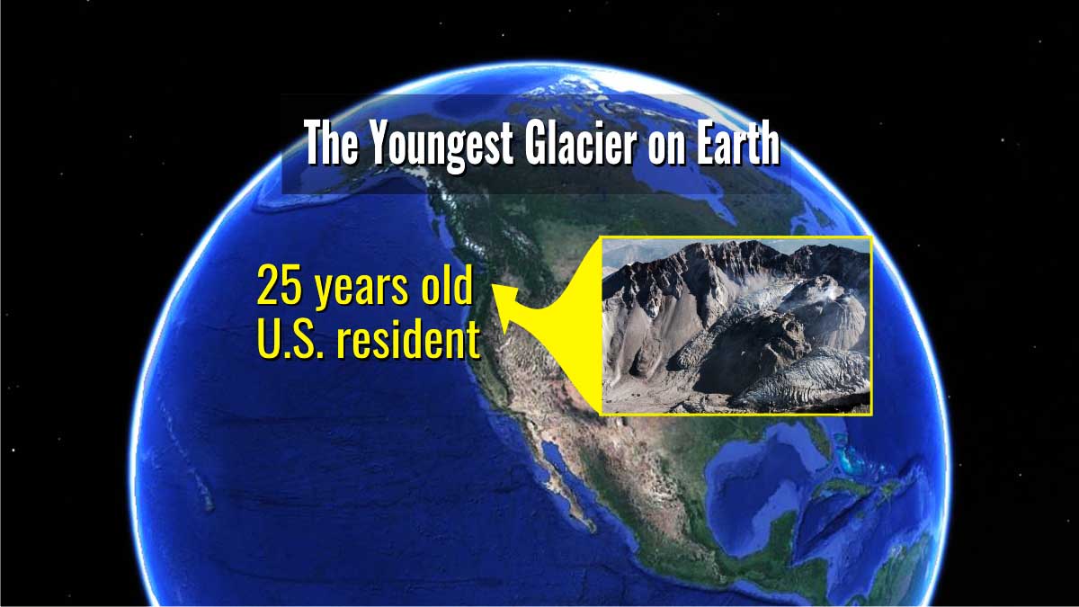
Anybody in the world has seen a glacier grow from almost the very first snowflake. This is the fastest new glacier growing for the continental US, and beyond. While most of the glaciers are receding on mountains because of global warming, this one keeps advancing.
THE MOUNT SAINT HELENS ERUPTION
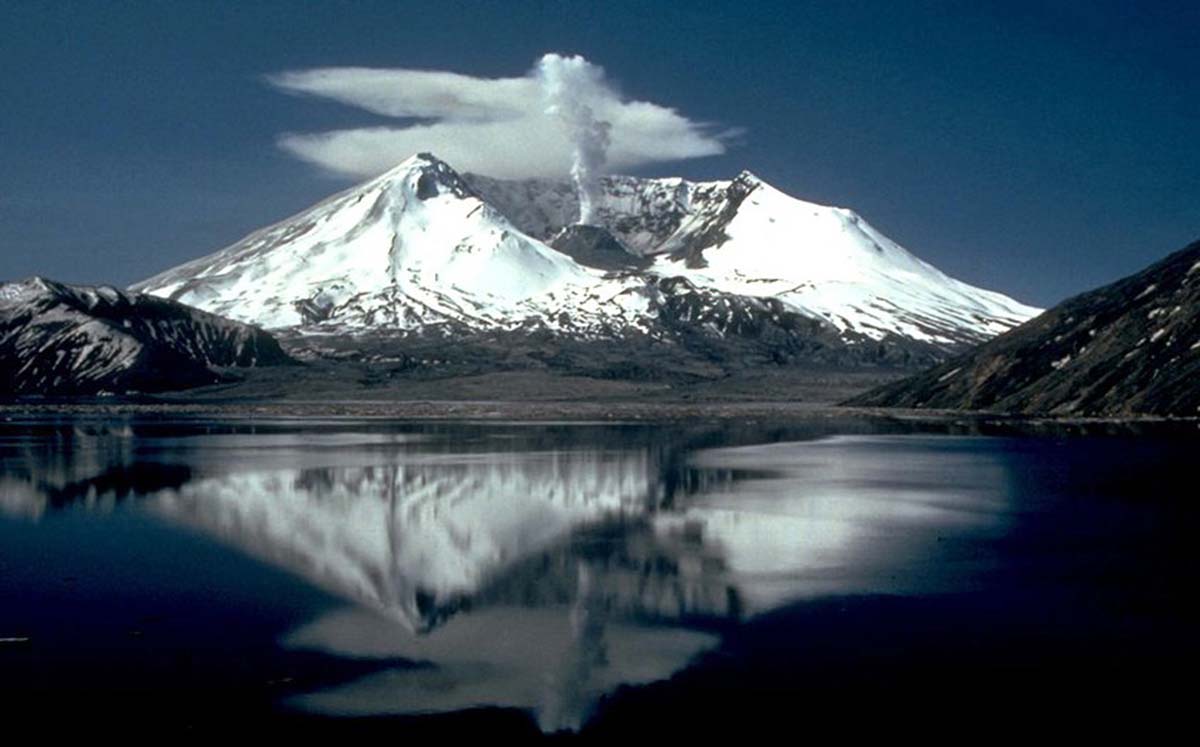
The cataclysmic eruption of Mount Saint Helens is one of the most powerful natural disasters in American history. On the morning of May 18th, 1980 the fifth highest peak in Washington state (2,950 meters or 9,677 feet high at that time) explodes with 500 times the force of the Hiroshima bomb. The dramatic volcano eruption instantly reshaped the surrounding landscape.
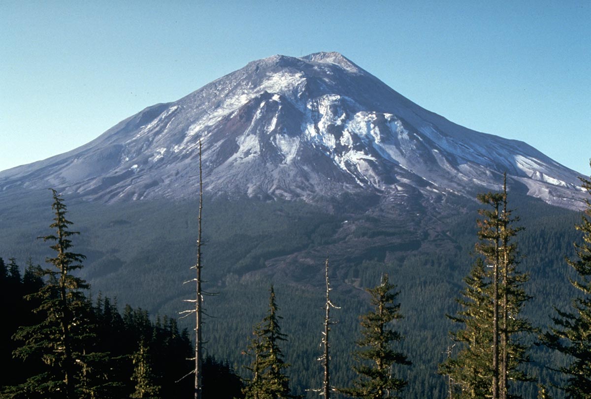
The image above shows Mount Saint Helens one day before the eruption. Credit: Harry Glicken, U.S. Geological Survey Department of the Interior/USGS
The destructive eruption caused 57 casualties and thousands of animals died. The devastation was widespread and 595 square kilometers (230 square miles) of the forest, were just leveled. The huge blast triggered the largest landslide on Earth in recorded history removing about 400 m from the top of the volcano as well as much of the northern flank.
More than 2.5 square kilometers of debris were moved, and an open crater about the size of downtown Seattle formed. In the video below you can see how Mount Saint Helens changed and how it developed later in time
When the northern face of Mount Saint Helens exploded, glaciers were completely destroyed. All the existing snow and ice in the crater was melted or blasted in the sky. About 70% of the existing ice volume at that time, was removed during the eruption.
In the image below credits, Jamie Woodward www.hoddereducation.co.uk/geographyreview you can see the distribution of glaciers before and after the 1980 eruption
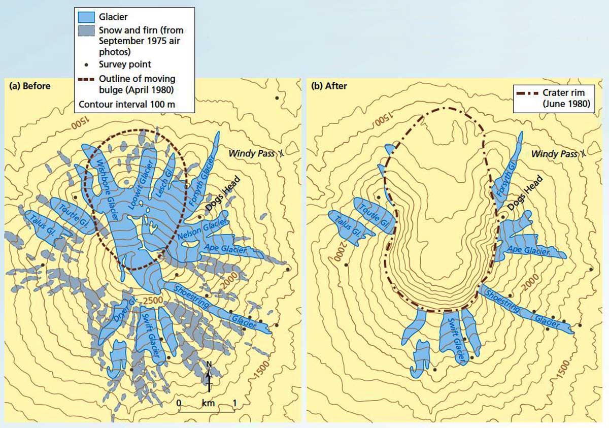
Before the eruption, Mount Saint Helens volcano was flanked by at least 11 named glaciers, and its crater was filled by snow and ice. Super-heated rocks and volcanic gases melted instantly the glacier ice. Massive lahar caused destruction downslope to the valley. But, what is a lahar?
The term lahar comes from Indonesia and refers to mudflows or debris flows down the slopes of volcanoes and down river valleys. Lahar is also commonly known by the term, volcanic debris flow. A lahar generally starts as a debris flow for the first few kilometers but then evolves into a hyper-concentrated flood flow
On volcanoes with perennial snow or glaciers, pyroclastic flows sweeping downslope can rapidly transform into lahars that can be very far traveled. Due to their high density, the impact of lahars on structures and the environment is often devastating.
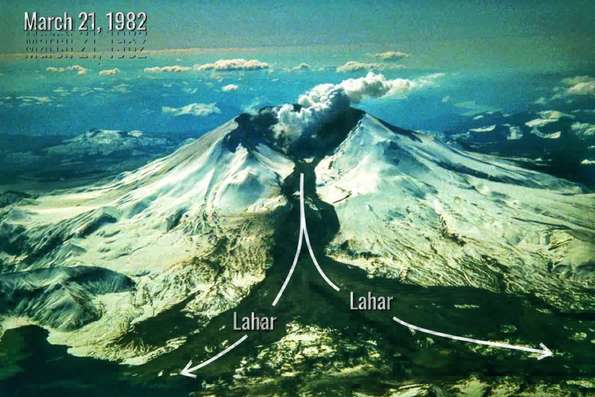
The image above, Credits Tom Casadevall. Original picture available at the following link https://www.usgs.gov/media/images/lahar-dark-deposit-snow-originating-mount-st-helen
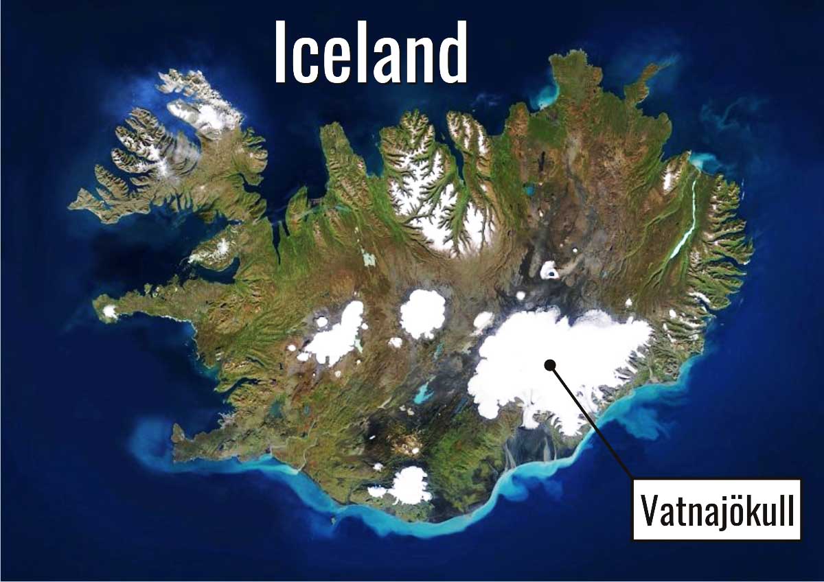
Lahars are often linked with jökulhlaup, which is a type of glacial outburst flood. Jökulhlaup Is an Icelandic word and generally refers to subglacial outburst floods from the Vatnajökull ice cap in Iceland, the biggest Earth’s ice cap.
A Jökulhlaup is triggered by geothermal heating and occasionally by a volcanic subglacial eruption. Nevertheless, the term is now used to describe any large and abrupt release of water from a subglacial or proglacial lake/reservoir.
THE BUILD UP OF NEW VOLCANIC DOMES
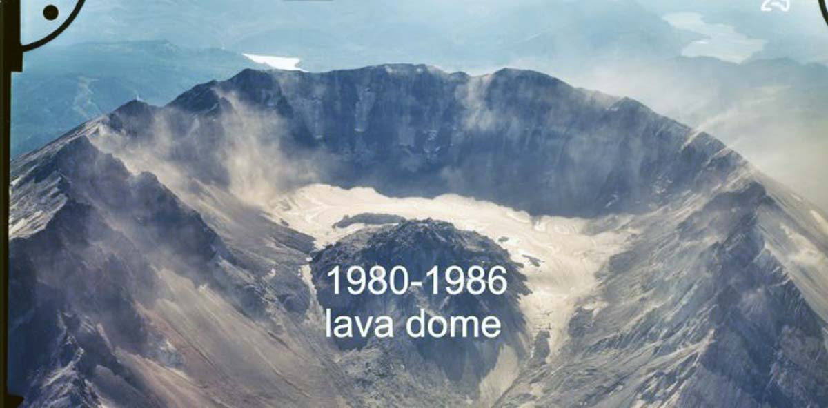
After such catastrophic events, up ahead an almost 300 meters (1000 feet) high volcanic dome has been growing in violent, and unpredictable fits and starts, ever since the 1980 eruption. The last phase of the first dome building was in October 1986. After that, steam eruptions occurred without any warning between 1989 and 1991.
But something new was happening at that time. Snow and ice south to the 1980-1986 volcanic dome started accumulating year by year giving birth to a small glacier
The build-up of the first 1980-1986 dome. Credit USGS
But how does a glacier forms in a volcanic crater? Permanent ice bodies form when long-term climatic conditions (not a single season or few of them) allow recursive positive mass balance. The accumulation of ice due to snow metamorphism must exceed mass losses. This balance is mainly controlled by two climatic variables: winter/annual snowfalls and summer temperature. Both can be influenced by local factors.
The most important are aspect and local topography. In volcanic settings, heat from the volcano can raise rates of snow and glacier melt, increasing the ablation. Seismic activity, instead, can trigger snow avalanches from steep crater rims acting on accumulation processes.
One of the main reasons why this glacier-formed is because it’s on the north side of the mountain, which has little sunlight so the shadows keep the snow from melting. More, frequent avalanches feed the accumulation area of the Crater glacier multiplying the amount of snow coming from precipitation.
A NEW GLACIER
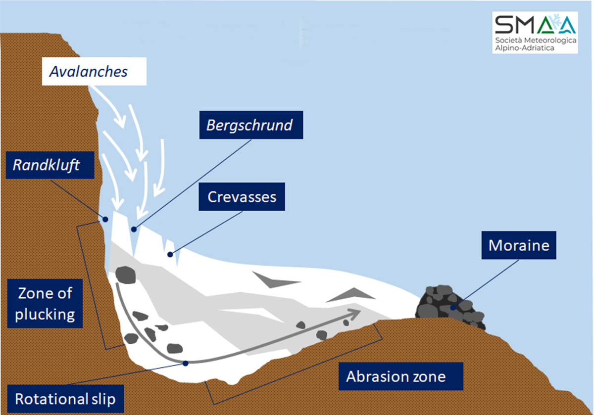
The glacier was first observed and confirmed 25 years ago. Aerial photographs taken in September 1996 revealed a small glacier in the southwest portion of the amphitheater containing several crevasses and a bergschrund-like feature at its head.
In the image below, a bergschrund is a crevasse that forms where moving glacier ice splits from the stagnant ice above. More info on how glaciers form is available at this link when we were talking about small glaciers in the Alps
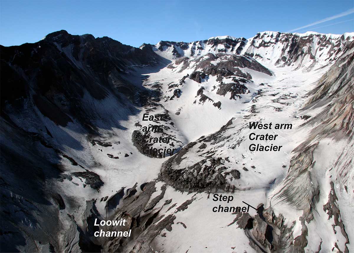
The second dome building started in 2004, south to the 1980-1986 dome. But at this stage, something new was already established in the Mount Saint Helens crater. The enlarged amphitheater-like crater was home to a new glacier, the youngest glacier on Earth. Its name is Crater glacier, although others know it as Tulutsa glacier
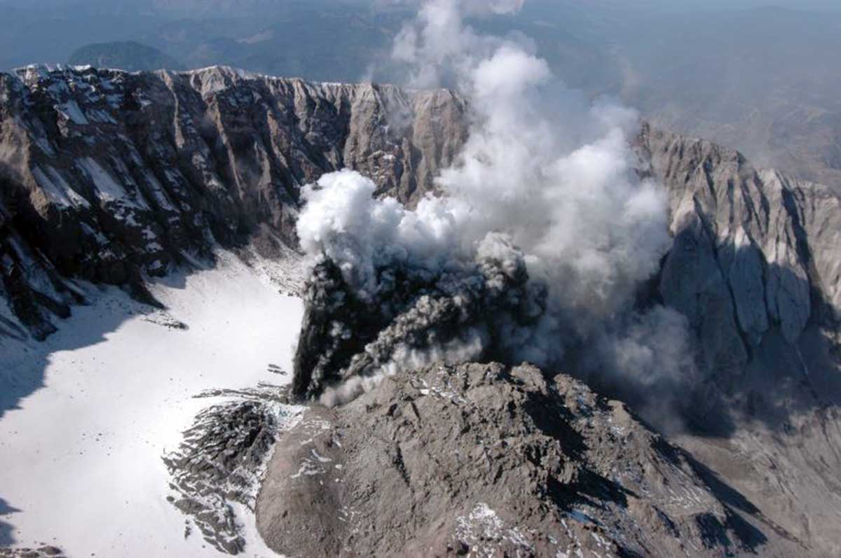
The image above shows the beginning of the 2004 eruption through Crater Glacier. Credit USGS photograph by J.S. Pallister.
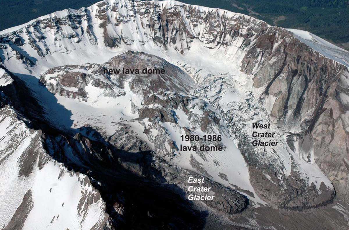
The growth of the new volcanic cone from 2004, forced the baby glacier to develop two tongues of ice. As this cone expanded, it squeezed the glaciers against the crater walls and increased their flow velocity in a sort of glacier surge. In the image below on November 20, 2004, a whaleback-shaped lava dome had grown southward and run into the south wall of the crater.
This event split the glacier in two, separating the two tongues of ice. The crater glacier East and the West now extended from the main ice mass around both the East and the West sides of the lava dome that occupies the center of the crater floor.
The image above USGS photograph by D. Dzurisin
NOT ONLY A GLACIER, BUT ALSO ROCK GLACIERS
At the same time, scree slopes were home to the birth of rock glaciers both on the East and West sides of the crater. The term rock glacier defines a thick lobate or tongue-shaped mass of debris moving downslope through the deformation of subsurface ice and/or ice-rich sediments. Generally, the downslope movement is geomorphologically indicated by a system of transverse surface ridges and furrows.
The ice within a rock glacier might come from ice-supersaturated mountain permafrost, from glacier ice, or represent a continuum between glacial and non-glacial origin. Active rock glaciers are characterized by the widespread presence of buried ice, sufficient to induce internal deformation, creep, and movement.
 The image above: two rock glaciers flow down the scree slope of the Mount Saint Helens crater in 2004. Credit GoogleEarth
At this stage, owing to the surge triggered by the new dome building up in the accumulation area, the flow of the two glacier tongues accelerated and rapidly grew in size. The extent of the glacier in 1996 was probably about 0.1 square kilometers. By September 2001, the debris-covered glacier had grown to about 1 square kilometer in area, with a maximum thickness of about 200 meters. The estimated volume was estimated at about 120,000,000 cubic meters.
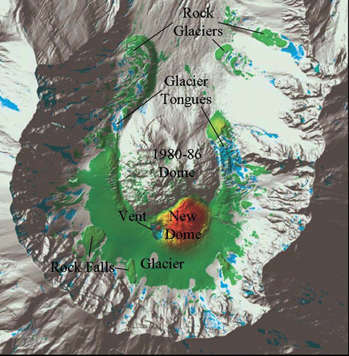
At this stage, the newly formed glacier was not only the largest glacier on Mount St. Helens but its aerial extent exceeded that of all other remaining glaciers combined. A huge rock glacier, the largest in the amphitheater, formed on the West side of the crater too. The image below shows the geomorphological map of glacial, periglacial, and volcanic features in the early 2000s. The biggest rock glacier is the one on the left.
Glaciers, of course, are not uncommon in the Cascade’s, but the rapid pace of this glacier’s growth sets it apart from others in the northwest U.S. What is extremely interesting about this glacier is that is growing unusually fast. Anybody in the world has seen a glacier grow from almost the very first snowflake.
This is the fastest new glacier growing in the continental USA, and beyond. While most glaciers are receding on mountains because of global warming, this one keeps advancing. Just 50 miles away is Mount Rainier, a more typical Cascade peak with several dozen glaciers sprawling down the mountain’s flank. But Rainier is a relatively inactive volcano and its glaciers are shrinking due to global warming.
 The image above: The two growing glacier tongues in June 2007. Credits USGS photo by M. Logan
One of the main reasons why this glacier is advancing and accumulating, it’s on the north side of the mountain, which has little sunlight. The shadow keeps the snow from melting. More, the constant feeding of debris and rocks also ends up scattered on the ice.
This layer of debris forms an insulating blanket, that keeps further the ice from melting and allows the glacier to build larger and larger every day, especially towards the front.
In the image below credits USGS, photo by A. Diefenbach, the two glacier tongues touched on My 30, 2008. From now on a unique glacier tongue formed, further accelerating the flow.
THE TWO TONGUES MERGE IN ONE
Tulutsa (or Crater) glacier, has largely remained out of sight of the public. Even more surprising than its location on an active volcano, is the fact that the glacier continues to grow while most others around the world are in fast retreat.
Over the decades, this baby glacier grew into the Hulk it is today and it’s growing in thickness by up to 15 meters per year. Once united in 2008, the two glacier tongues pushed the glacier growing allowing scientists and glaciologists to face something extremely rare around the world. A glacier that is not retreating!
This is basically one of the only chances a young glaciologist has, to see in person how a glacier grows and advances.
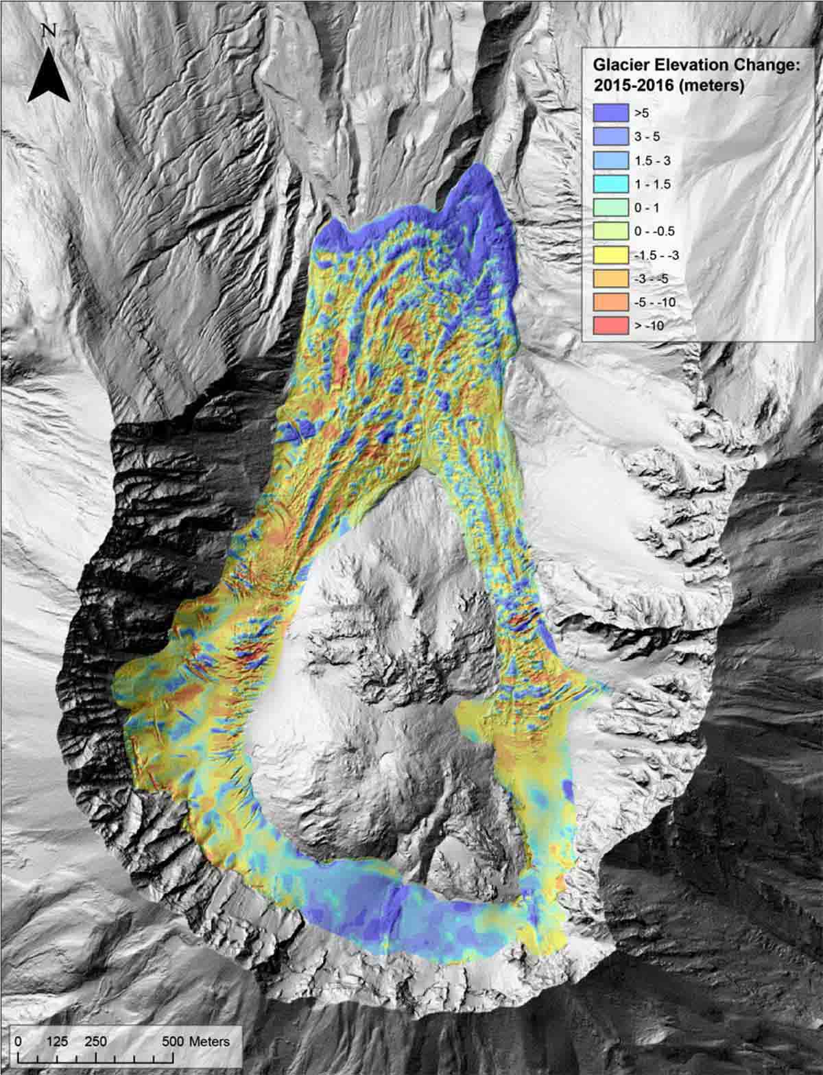
In the image above, credits USGS, you can see thickness variations between 2015 and 2016. Look how the accumulation area grew by more than 5 meters in only 1 year (bottom of the figure) as well as the glacier terminus (upper part of the figure).
In the video below, we prepared the 1996-2018 time-lapse of Crater glacier evolution, thanks to 3-D high-resolution images from Google Earth. It is indeed impressive the acceleration of the glacier after 2008 when the two tongues unified.
The Crater Glacier is now about 2.76 kilometers (1.71 miles) long from the accumulation area to the unified terminus. The glacier is more than 200 meters thick in some places. That’s close to the length of two football fields. The crater and the youngest glacier on Earth have become a scientific curiosity. International teams of scientists spent weeks up there researching.
In the image we edited below, we set a map to show how it looks now the Crater glacier. The background image is a hillshade-relief map freely available from the Washington Lidar portal https://lidarportal.dnr.wa.gov/
The glacier flows around the two lava domes while two active rock glaciers reached the right side of the East branch of the glacier.
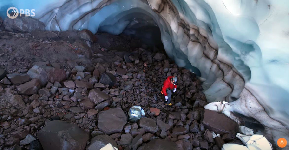
BELOW THE CRATER GLACIER, EXPLORING ICE CAVES
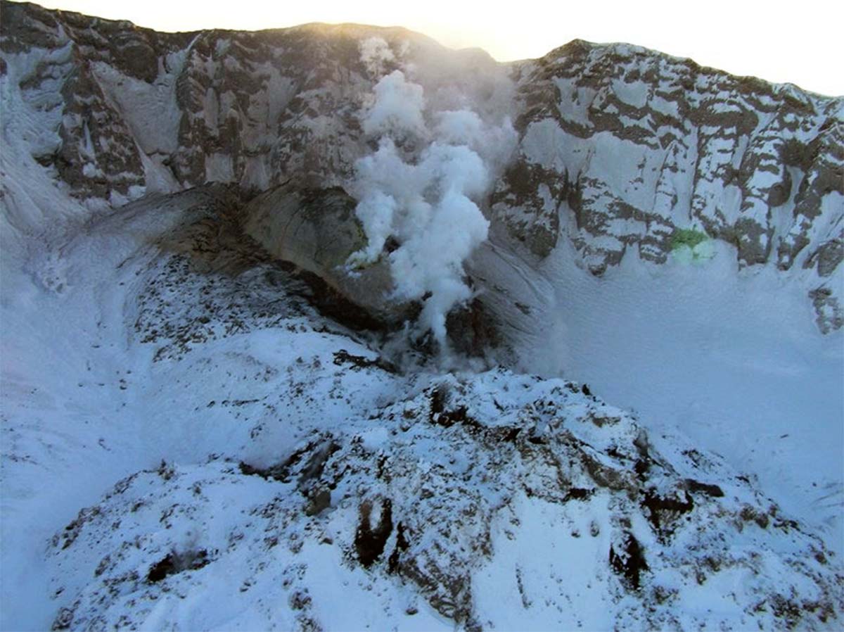
Although this glacier looks solid, it is actually riddled with cavities. These caverns are a sign that the volcano remains active. Vents in the crater known as fumaroles belch scalding hot steam and gases. This hot steam and gas melt holes in the glacier.
Some of the caves can wind a mile or more through the glacier. Inside, it’s a risky and alien landscape of dripping ice. For scientists, the opportunity to study this unique environment is worth the risks. Mount Saint Helens is the most active volcano in the continental US and this glacier could serve as an early warning system of sorts.
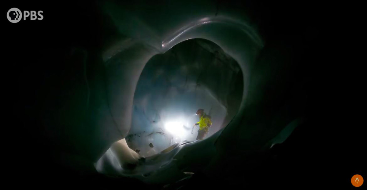
The image above is a screenshot from the original documentary Why Earth’s Newest Glacier Is Inside An Active Volcano
Driven by the fumaroles, these glacier caves are really active. If the melting is getting stronger and the glacier would retreat this could be a sign for the next eruption. More, astrobiologists try to find an analog here on Earth that is similar to an environment in space.
Mount Saint Helens is a very extreme environment, especially in these glacier caves because it’s dark and nothing has ever grown in these environments. The eruption of 1980 basically sterilized the volcano, So anything that scientists find here allows them to look at the ways that life can inhabit a new system.
The image above is a screenshot from the original documentary Why Earth’s Newest Glacier Is Inside An Active Volcano
By learning about how the smallest forms of life develop in extreme environments on Earth, scientists are hoping to gain a deeper understanding of what to hunt for, on places like Mars. Therefore, by looking inward at this volcano scientists are actually looking out into our solar system.
FUTURE HAZARDS
Beyond those magnificent discoveries, other quiescent hazards exist. One of the dangers would be if the volcano will become active again. There’s a pretty good source of ice and debris within the crater to trigger a lahar if there’s a significant eruption.
It’s already happened before during the 1980 eruption. The mountain top glaciers dissolved, joining rock and other volcanic debris to form a massive lahar that swept down the Toutle River valley.
The lahar hazard would be tremendous because of all the glaciers that were obliterated in 1980, almost all of the mass is back in the crater right now.
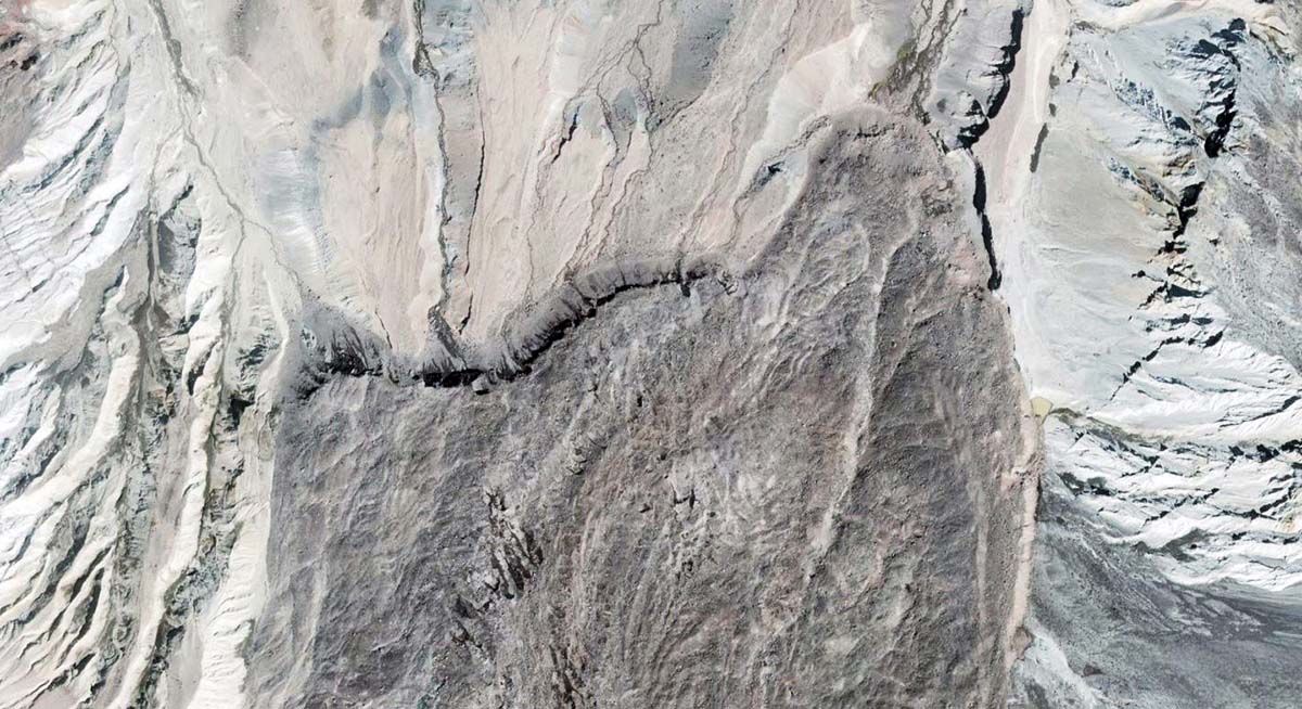
The image above shows a detail of the debris-covered glacier front of Crater glacier in 2021, from a high-resolution GoogleEarth picture
The question on every geologist’s mind is when will this mountain erupt again. Predicting that is the trickiest part of volcano science. At the USGS National Volcanic Laboratory in Vancouver, Washington seismographs act as an early warning system gathering real-time earthquake and tremor information, from sensors placed on the mountain.
They are always monitoring Mount Saint Helens because it is the volcano that’s erupted the most frequently in the Cascades
We will keep you updated on this and much more, so make sure to bookmark our page. Also, if you have seen this article in the Google App (Discover) feed or social media, click the like button (♥) to see more of our forecasts and our latest articles on weather and nature in general.