While Arctic sea-ice declines, huge holes are opening in the so-called Last Ice Area north of Greenland and Ellesmere with increased frequency. Here, the oldest and thickest sea-ice of the Arctic still survive. The recent development of polynyas, also related to Sudden Stratospheric Warming, pose new insights into the resilience of the last frontier of the Arctic ice-pack. Progressive thinning ice could trigger more such events in the future.

ARCTIC SEA ICE DECLINE
Arctic sea ice reached its minimum on September 16 this year, and its extent is now rising fairly rapidly as usual. The summer of 2021 was relatively cooler in the Arctic compared to the most recent years, and the minimum annual extent was the highest since 2014.
According to the U.S. National Snow and Ice Data Center (NSIDC), the Arctic sea-ice minimum extent was 4.92 million square kilometers (1.90 million square miles), the twelfth lowest in the 43-year satellite record. This is 1.49 million square kilometers (575,000 square miles) below the 1981 to 2010 average.
To learn more about the 2021 Arctic Sea Ice season you can read our recent article here

September Arctic sea ice is declining at a rate of 13% per decade, relative to the 1981 to 2010 average. The last 15 years (2007 to 2021) have had the 15 lowest September extents in the record according to the NSIDC.
Annual Arctic sea-ice minimum extent decreased from an average of more than 7 million square kilometers (2.7 million square miles) in the early 1980s to about 4.5 million square kilometers (1.7 million square miles) on average in the last 10 years.
The animation below shows the annual Arctic sea ice minimum each September since 1979, derived from satellite observations. The lowest sea ice extent in the satellite record occurred in 2012, the highest in 1980.
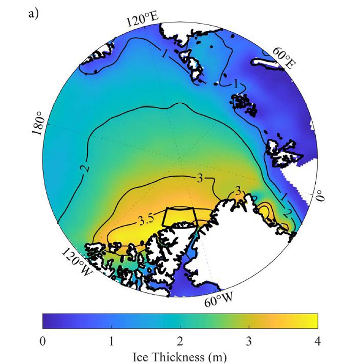
But Arctic sea-ice reduction is not only a matter of surface but also thickness and age of the ice itself. Average ice thickness in September constantly decreased in the last four decades, and today sectors of ice more than four meters thick are very small in area.
The image below shows the average sea-ice thickness in September from the 1980s to the 2010s. Sea-ice thickness reduction is particularly evident and dramatic in the last ten years. This is happening because increasing summer melting avoids the preservation of older ice over the years.
In winter new young ice forms, which is however more easily vulnerable to the subsequent Spring melting. Once spring and summer arrive, most of this first-year ice quickly melts. If, however, it survives summer, it is promoted to multiyear ice.

Sea-ice thickness is directly linked to sea-ice age. A thicker sea-ice is also generally less vulnerable to the summer melting. Although Summer 2021 ended with a decent amount of residual sea ice, this was nearly the lowest end-of-the-season amount of multi-year ice.
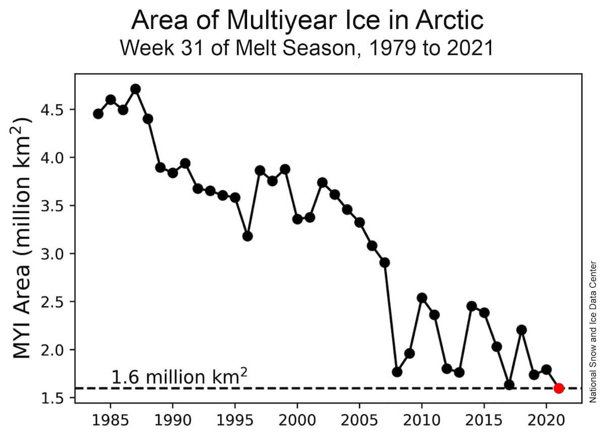
The multi-year sea-ice reduction is particularly evident starting from the 2000s. In 1979 the extension of multi-year sea-ice was about 4.5 million square kilometers (1.7 million square miles). Today the area reduced by 2.9 million square kilometers (1.1 million square kilometers) and is now equal to about 1.6 million square kilometers (1.7 million square miles)
Only 1% of today’s ice pack and sea ice is old, thick ice. The image below shows the evolution of the sea-ice age from 1985 to 2019 and the result is extremely obvious. Most of the present ice-pack in the Arctic today is made by young ice, not more than 1-year-old sea ice.
The oldest sea-ice which lasted for more than 4 years, represents today only a miserable part of the total ice. In 1985 the > 4 years old sea-ice represented 35% of all the Arctic ice-pack. On the contrary, the youngest ice with less than 1 year of age, represent the majority of the ice-pack today. It covers an area of about 3.1 million square kilometers (1.2 million square miles), 70% of the total sea-ice area.

THE LAST ICE AREA
The only sector of the Arctic where old and thick ice can be still found is located north of Greenland and Ellesmere Island in the Canadian territory of Nunavut. This sector has recently been referred to as the Last Ice Area. Basically, the area refers to the predicted summer sea-ice extent projected to the year 2040 and beyond.
Here ice has persisted there in late summer decades while in other regions ice largely melts away. In the Last Ice Area, ice is the thickest and the oldest in the Arctic, mainly because ice circulation tends to keep it pressed against the northern coasts of Ellesmere Island and Greenland.

Climate projections forecast the total disappearance of summer sea ice in the Arctic by 2040, with the exception of the Last Ice Area. The Last Ice Area might represent the last refuge for ice-dependent species as the world warms. The Last Ice Area will likely harbor the largest concentration of Arctic wildlife dependent on the sea-ice edge for survival, including bowhead whales, seals, narwhals, and polar bears.
Nevertheless, in the summer of 2020, the easternmost portion of the LIA, known as the Wandel Sea, had a record low sea ice concentration.
The LIA is a typical example of a coastal sea-ice connected with the ice-pack. In the image below here is a schematic representation showing some of the most common sea-ice-related features.
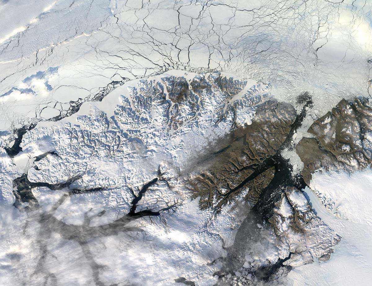
Photo satellite Earth Observation NASA
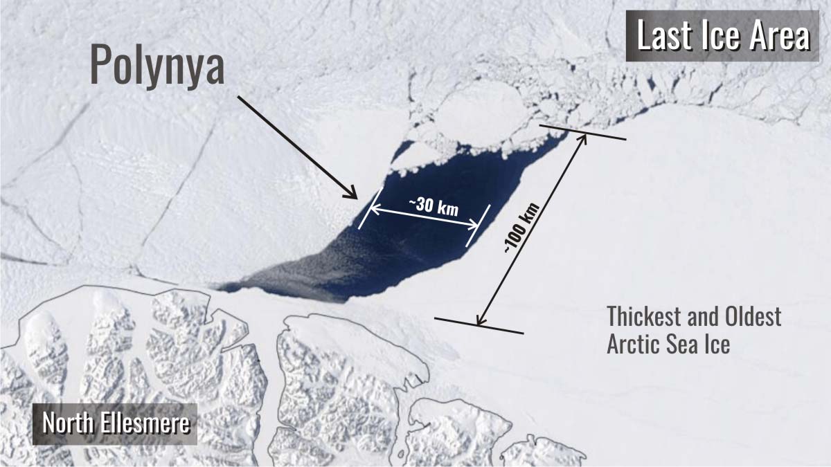
Arctic scientists believed the LIA was largely resistant to melting as the planet warmed. However, new scientific paper are available in the scientific journal Geophysical Research Letters shows a huge hole approximately the size of Rhode Island opened up there in May 2020.
Dr. Moore, the first author of the research, and others report how visible satellite imagery as well as sea ice concentration derived from passive microwave satellite data both indicate that this huge hole was preceded by the formation of an elongated flaw lead that developed on May 14, 2020.
A day later on the 15th, the flawed lead began to evolve into a huge crack with open water that had an area of ∼2,000–3,000 km2 and that persisted for 10 days before closing on the 26th. At its maximum extent, it was elliptical in shape with a major axis of ∼100 km and a minor axis of ∼30 km. Scientists call this structure Polynya.
WHAT IS A POLYNYA?
Polynya is a geographical name describing an area of unfrozen seawater within the otherwise contiguous pack ice or fast ice. The word derives from the Russian language and refers to a natural ice hole. It was first adopted in the 19th century by polar explorers to describe navigable portions of the sea.
Polynyas occur within sea ice stretches even though the air temperature is below freezing. Such gaps in the thick ice-pack provide direct interaction between the ocean and the atmosphere, which is important for the wildlife. There are two main types of polynyas: coastal polynyas, and mid-sea or open-ocean polynyas.
Although coastal Polynyas are mainly created by strong winds pushing the ice away from the coast, they are subdivided in two different types: Sensible-heat polynyas, and Latent-heat polynyas.
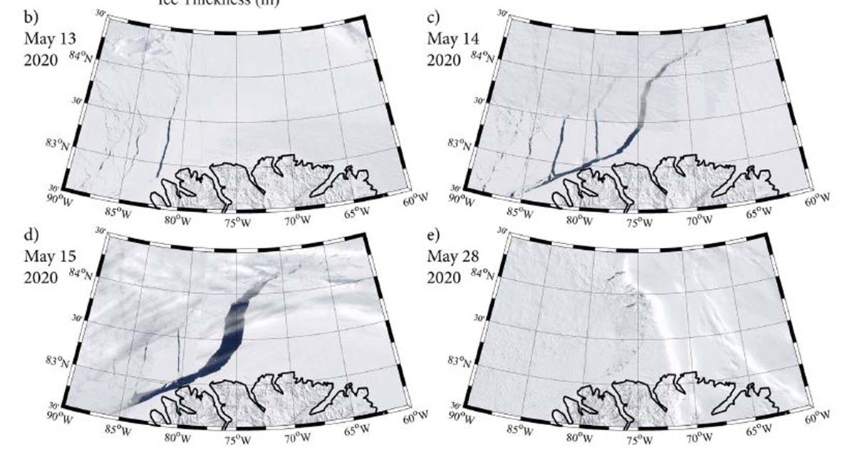
In the image below the evolution of the Polynya observed in May 2020
A sensible heat polynya is thermodynamically driven and usually occurs when warm water upwelling keeps the surface water temperature at or above the freezing point. This cuts ice production and may stop it altogether.
A latent heat polynya forms through the action of strong katabatic winds. Winds act driving ice away from a fixed edge such as a coastline, fast ice, or an ice bridge. The polynya forms primarily when first-year (young) sea-ice is driven away from the coast. This leaves an area of open water within. The new ice is then piled up downwind toward the first-year pack ice.

Image Credits Alfred Wegener Institute for Polar and Marine Research, Bremerhaven, Germany |Permission=Own work, share-alike, attribution required (Creative Commons CC-BY-SA-2.5)
The polynya observed in May 2020 is the first one that has been identified in this sector of the Last Ice Area. The development of the polynya was unusual mainly because of its location. It formed just off the coast of Ellesmere Island, where the ice is the oldest and up to 5 meters (16 feet) thick.
The authors of the research declare that apparently, nobody had seen a polynya in this area before. North of Ellesmere Island it’s hard to move the ice around or melt it just because it’s thick, and there’s quite a bit of it. So, no one generally has seen polynyas forming in that region before.
The astonishing polynya formed during extreme wind conditions in a persistent anti-cyclone with high winds rotating clockwise. Searching through decades of sea-ice imagery and atmospheric data scientists found that indeed polynyas formed there at least twice before, under similar atmospheric conditions, in 2004 and 1988, but no one had noticed.
Nevertheless, it is indeed unusual for sea ice as thick as in the Last Ice Area to be blown around, especially far off the coast where the wind is generally weaker than near the coast. This means that even places with robust ice some 5 meters (16 feet) thick or more are increasingly vulnerable in today’s warming climate.
This new evidence, therefore, shows the Last Ice Area may not be as resilient to Global Warming as previously thought. There is other evidence too.

The wind speeds during the 2004 event were even higher. However, the resulting polynya was smaller than that in 2020. Scientists think that the trend toward thinner ice that is occurring within the LIA contributed to the larger polynya in 2020 despite weaker forcing.
Taking it simpler, unusual winds were of course a significant factor, but a result of natural variability. But the persistent long-term thinning trends in the Last Ice Area multi-year sea ice pack is also to blame. Winds would not have had such a large impact in previous decades when the pack was thicker on average. More, there is a tendency for larger areas of open water in this Arctic area during May since 2014.
THE FEBRUARY 2018 POLYNYA AND ITS CONNECTION WITH SUDDEN STRATOSPHERIC WARMING
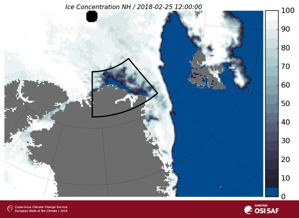
During late February and early March 2018, an unusual polynya was observed off the north coast of Greenland. An area the size of the state of Kentucky or the province of Nova Scotia having 50,000 square kilometers (19,300 square miles) in size opened. In this case, wind dynamics alone and not thinning ice were responsible for such a development.
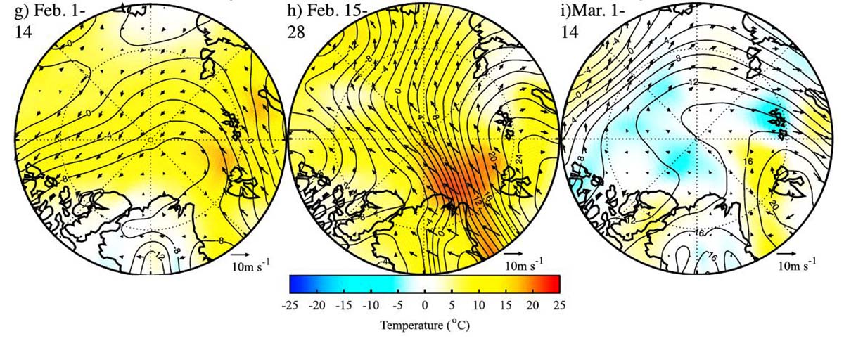
This period was also notable for the occurrence of a Sudden Stratospheric Warming. The Sudden Stratospheric Warming began on 12 February and was one of the largest of all observed Sudden Stratospheric Warming since 1958.
A Sudden Stratospheric Warming event is an abrupt temperature rise in the polar stratosphere during the cold season. Warming of the stratosphere means that the polar vortex becomes weaker and eventually collapses under the pressure from the warming event.
To know more about Stratospheric Warming you can read one of our latest articles.
In February 2018, stratospheric warming led to a collapse of the polar vortex. This caused winds from Siberia to blow cold air into northern Europe, creating a weather system that became known as the ‘Beast from the East’. It brought temperatures of -20°C to northern
Europe. The same weather pattern forced strong southerly winds and mild air towards Greenland.
Warm surface air temperatures up to +25°C anomaly over the northern Barents Sea were detected, but it wasn’t their warmth that caused the polynya. Deep analysis showed how even under past considerably thicker sea-ice the polynya would have still formed.
Above: The original image can be found at: What Caused the Remarkable February 2018 North Greenland Polynya?
Previous events were in fact also associated with the enhanced southerly flow but not with the occurrence of a Sudden Stratospheric Warming. Such a combination of overlapping events indicates the polynya was the result of divergent sea ice motion.
The event of May 2020, when compared to those occurring in May 1988 and 2004, offers a further indication as to the changing nature of sea ice within the Last Ice Area. The ice is thinning here too, and the importance of synoptic weather systems in forcing extreme ice events in the region is becoming crucial.
We will keep you updated on this and much more, so make sure to bookmark our page. Also, if you have seen this article in the Google App (Discover) feed or social media, click the like button (♥) to see more of our forecasts and our latest articles on weather and nature in general.
SEE ALSO:
The Orionid Meteor Shower 2021 Peaks This Week. Here is How to See and Photograph it