+++ Significant threat for severe weather outbreak with intense supercells capable of producing very large hail, damaging winds and tornadoes across E Germany, W Czech Republic and NW Poland is expected on Monday +++
SYNOPSIS
A deepening trough / low is located over WSW Europe with a strong upper ridge to its east, over ENE Europe and the Balkan peninsula. In between, a powerful SW-erly jet stream is established. An upper low over the E Mediterranean strengthens while moving north towards Turkey. At the surface, a broad cyclone is located across central Europe and the N Mediterranean with a secondary low forming on the lee (north) side of the Alps. An associated wavy cold frontal boundary / baroclinic zone extends from central Germany towards the N Mediterranean with a warm front extending and slowly advecting north across NE Germany into N Poland.
DISCUSSION
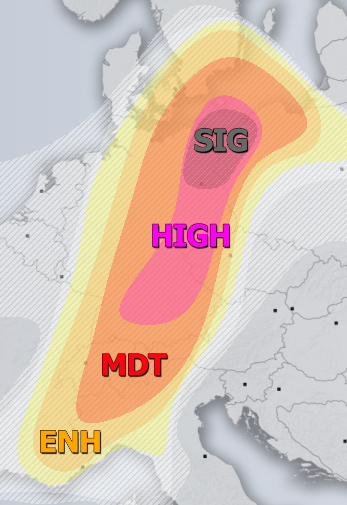
HIGH risk has been issued for E-NE Germany, W Czech Republic into NW Poland with threat for severe storms, capable of producing severe damaging winds, very large to giant hail, tornadoes (a significant event is possible) and torrential / excessive rainfall. A potentially dangerous setup is shaping up across the risk area through the late afternoon and evening hours as the environment becomes conductive for the explosive development of organized storms, including intense supercells. Extreme instability with MLCAPE locally in excess of 4000 J/kg will result from rapid moisture recovery with relatively strong SE-early low-level flow along the NE side of the Alps. The warm sector will be capped through the mid-afternoon hours under some upper/mid level clouds and should preclude storm initiation until the surface convergence strengthens along the progressing front and capping inversion weakens. Extreme CAPE overlapping with strong 40-50 knots of deep-layer shear and 300-500 m^2/s^2 of SR helicity should result in rapidly developing and organizing convective storms, supported by large-scale ascent aloft. Intense supercells will develop, bringing very large hail, severe winds and torrential rainfall. An impressive low-level CAPE and helicity due to E-SE inflow should also rise potential for tornadoes with the strongest cells, as well as potentially very large to giant hail in excess of 8 cm in diameter. Into the evening hours, storms should grow upscale into one or more mesoscale convective systems (MCS) moving NNE-wards, resulting in potentially dangerous severe damaging winds, torrential / excessive rainfall and large hail.
SIG risk (hatched area) has been placed across parts of NE Germany and NW Poland where conditions are extremely favorable for the development of tornadic supercells in a narrow corridor along the northwards advecting warm front. An impressive strong easterly inflow layer along the front results in strongly enhanced low-level (0-1 km layer) shear (20-30 knots) and SR helicity ranging between 300-600 m^2/s^2! Overlapping with moderately strong instability with 2000-2500 J/kg of MLCAPE, any storm riding the front would have the potential to quickly become tornadic. These values could develop a significant tornado or two as well.
MDT / ENH / SLGT risks have been issued for areas surrounding the HIGH risk across Germany, S Sweden, W/N Poland, W-CNTRL Czech Republic, W Austria, Switzerland and N-NW Italy with threat for severe storms, capable of producing severe damaging winds, large hail, torrential / excessive rainfall and tornadoes. While very large hail and tornado threats are mostly limited to the northern half of the risk areas, excessive rainfall threat develops over the W Alps where a combination of intense convective storms and orographic precipitation develop flash floods threat across NW Italy and Switzerland. Elsewhere, organized severe storms are likely, including supercells as good overlap of moderately strong shear and instability will be in place. Threats have been expanded north towards Sweden for the reason of possible large cluster / MCS in the later evening hours, resulting in severe wind and hail threat. Could not exclude a couple of strongly organized supercells with very large hail and some tornado threat also across western parts of Po valley plains in N-NW Italy as well.
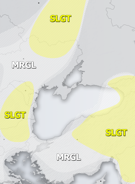
SLGT risk has been issued for parts of Romania, Bulgaria, Moldova and SW Ukraine with threat for severe storms, capable of producing torrential / excessive rainfall and large hail. Rather widespread slow-moving storms are again expected, locally with flash floods and hail accumulation threat.
SLGT risk has been issued for the E Turkey, N Middle East and Georgia with threat for severe storms, capable of producing torrential rainfall, severe winds and large to very large hail. A widespread activity of organized storms is expected, under moderately sheared and unstable environment. Very large hail event or two and flash floods cannot be ruled out either.
SLGT risk has been issued for the NE Ukraine into NW Russia with threat for severe storms, capable of producing torrential rainfall, severe winds and large hail.
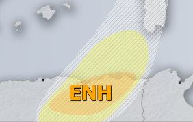
ENH / SLGT risks have been issued for the NE Algeria with threat for severe storms, capable of producing torrential rainfall, severe winds and large hail. Under a moderately sheared and unstable environment, scattered severe storms with large to very large hail are likely.
TSTM risk areas have been placed where convective storms are likely to occur but should remain sub-severe.


