SYNOPSIS
A strong ridge persists across N-NE Europe while an upper low over the S Balkan peninsula weakens. To the west, a very deep trough with an intense surface cyclone and front moves across WSW Europe. Another front, associated with the low over the North Sea, continues across central Europe towards east. Another focus for robust convective activity remains a stalled diffuse frontal zone extends from the Baltic sea towards Georgia.
DISCUSSION
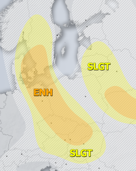
ENH risk has been issued for NE Germany, E-CNTRL Czech Republic, W Poland, W-CNTRL Slovakia and E Denmark into S Sweden with threat for severe storms, capable of producing severe winds, large hail and torrential / excessive rainfall. Scattered severe storms are expected to develop along and just ahead of the eastward moving cold front during the peak afternoon hours. Favorable moderate shear and instability should result in supercell storms as well.
SLGT risk has been issued for areas surrounding the ENH risk including E Austria, E Slovenia, Hungary, NE Croatia, N Serbia and E Slovakia with more isolated threat for severe storms, capable of producing severe winds, torrential / excessive rainfall and large hail. Weaker shear across the southern parts of the SLGT risk area should allow slow-moving storms with threat for accumulated hail and flash floods.
ENH risk has been issued for W-CNTRL and S Ukraine into SW Russia and Georgia with threat for severe storms, capable of producing large to very large hail, severe winds and torrential / excessive rainfall. Again, a rather widespread convective activity is expected within strong instability but low shear environment.
ENH risk has been issued for N Turkey with threat for severe storms, capable of producing large to very large hail, severe winds and torrential / excessive rainfall. Very strong MLCAPE under moderate shear could support some very large hailstones.
SLGT risk has been issued for areas surrounding the ENH risks including NE Turkey, NE Poland, W Belarus into the Baltic region with more isolated threat for severe storms, capable of producing large hail, severe winds and torrential / excessive rainfall.
ENH / SLGT risks have been issued for NW Spain, N Portugal into the Bay of Biscay with threat for severe to extremely severe winds, locally in excess of 120-140 km/h, associated with a deep cyclone moving through. Convective cells could, despite a rather low instability, result in higher severe winds threat. Strongly enhanced LL shear and helicity across the warm sector could also support tornadic storms.
TSTM risk areas have been placed where convective storms are likely to occur but should remain sub-severe.


