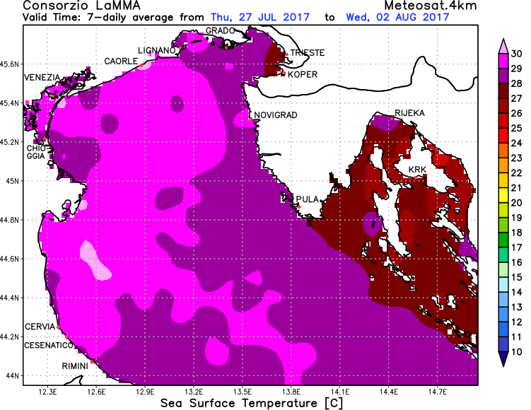
The Adriatic sea has hit 29-30 °C in its northernmost part already on Tuesday, and will be getting even warmer by the end of the week.
Temperatures along the northern coast (Friuli, Veneto – north Italy) have already reached 28-30 °C and locally even higher, in the quiescent lagoons (Grado, Venezia). 29 °C mark at 2 m depth was also reached at the Debeli Rtič (Zora) station on the Slovenian coast.
Current Adriatic sea surface temperatures indicate surface temperatures in 27-30 °C range across most of the northern Adriatic, 28-30 °C in the western Adriatic along the coast of central Italy, and somewhat cooler 24-26 °C in the southern Adriatic and locally in the eastern Adriatic. Temperatures are set to rise by 1-2 °C locally by the weekend.
Overall these temperatures are well above the long term average, with temperature anomaly exceeding +3 °C across much of the Adriatic sea, compared to the long term average. Very high sea surface temperatures inhibit night time cooling along the coastal regions, indeed many locations along the coast of northern and western Adriatic will not drop below 30 °C (air temperature) at night over the next few days. Also, increased rates of evaporation increase humidity and may well result in higher instability and intense thunderstorms across the region during any forthcoming cold fronts.
