Extreme cold is expected to develop across the eastern and central parts of Europe, including the Balkans through the second half of this week. Very cold weather with local winter storm events will develop. In addition, the Polar Vortex vortex collapsed after a major Sudden Stratospheric Warming (SSW) event last week which is expected to have a significant effect on our weather pattern in the coming weeks. Trend is now turning into favorable winter weather and snowy periods next week that could continue into the rest of January 2021.
Soon after the significant Sudden Stratospheric Warming (SSW) event and the Polar Vortex collapse, we could see how trends in pattern across the European continent are shifting. What has been observed lately is that an intense cold outbreak shoots an extreme cold into the eastern half of Europe this week, while strong blocking is developing over the Arctic region.
The result of both with then introduce a shift in the pattern into potentially very large trough/depression developing across much of Europe next week. This combination of blocked Arctic and trough over Europe should introduce a winter period for many parts of Europe, coming up next week and extending into late January.
Attached below is the video animation of the pattern evolution over Europe and North Atlantic over the next 10 days, based on the ensemble model forecast. We can see how parts of Europe are first blasted by extreme cold in the coming days, then cold first intensifies across northern Europe and gradually spreads south into western and central Europe as well.
So, as we can now see on the weather model trends, the first effects of the Polar Vortex collapse will start with extreme cold and snow in the eastern part of Europe and the Balkans. But then, it is also increasingly likely that a strengthening of the large depression over much of Europe develops over Europe next week. This could mean much colder and snowier parts of Europe.
Let’s take a deeper look into the general weather pattern evolution next:
ATLANTIC AND ARCTIC ARE LOCKED
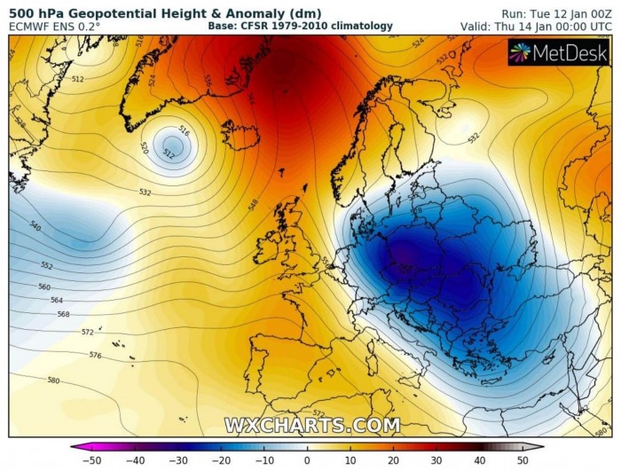
The general pattern across the North Atlantic and Europe is finally showing that good winter feels by just looking at it. A deep upper trough is intensifying over northern and eastern Europe through mid this week, becoming very deep on Thursday (tomorrow). This is a great pattern stage for continental Europe as the Arctic region and western Europe are fully blocked, so no warm westerly intrusions are possible.
So the flow turns northerly and opens a stage for Arctic air mass moving south. However, the only limitation such a pattern brings is the lack of moisture in the western parts of Europe, for now.
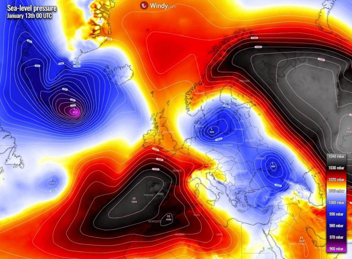
As the upper trough deepens into the eastern half of Europe, the associated surface low strengthens as well. Actually, a broad region of lower pressure spreads from southern Scandinavia across eastern Europe into the Black Sea region. Two cores form, one over the Baltic Sea and another over southern Ukraine on Thursday. Strong high-pressure systems expand from the Azores into southwestern and western Europe, while powerful Russian High is set to the east of Ural mountains.
Both surface low help to spread the cold advection from extremely cold, continental air mass from Russia towards Europe starting on Wednesday into Thursday. First, much colder air mass spread into Scandinavia, with nearly 10 °C below normal temperatures. The close-relation by both surface low favors the channeling flow from northern Europe into the central and eastern part of the continent, so the cold advection gradually intensifies.
It remains slightly warmer than normal under the upper-level ridge and surface high-pressure system spread across western and southwestern Europe. Notice also an extreme warmth developing over Greenland, which is an effect of a strengthening upper ridge over the Arctic region – an important role for the further pattern evolution towards Europe. Keep in mind that blocking High over Greenland turns the flow from the northeast to its eastern side, so air mass advection comes from Arctic Russia or Siberia towards the west.
EXTREME COLD DEVELOPS THROUGH FRIDAY INTO SATURDAY
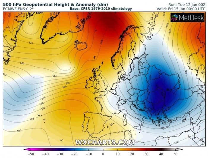
Towards the end of this week, the upper-level pattern is being locked-in across the European continent. Simplified this means, that the blocking ridge over the North Atlantic with Greenland and Russia on the other side prevents the upper trough/low to make any big moves. So it basically sits over eastern Europe and the Balkan peninsula, feeding with the channeling flow from cold Arctic Russia. This definitely gives us an idea something extreme is brewing up for part of our continent.
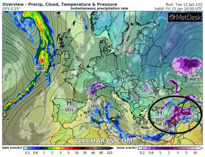
Now let’s see the surface pressure forecast on Friday. The high-pressure system covers a large part of northern, western, and southwestern Europe, while surface pressure is lower to its east, over the Black Sea region and southeast Europe. This indeed supports northerly flow into the region and it doesn’t mean anything else than a cold period ahead there. Notice there is also a shallow wave to the southwest of Iceland, it will also help the pattern change later on.
In response to such northerly flow, extremely cold air mass begins spreading into eastern and northeastern Europe from the east. Keep in mind western and central Russia are under strong blocking High, so brutal cold is trapped beneath. Part of this air mass begins spreading into the eastern portions of the European continent through Friday and continues into the weekend while expanding further south towards the Balkans and the Mediterranean.
Remember we have mentioned the locked-in pattern shaping up, that is why also Saturday and Sunday (upcoming weekend) will see a literally same pattern setup as on Friday. Hard to see any differences as we can see. A very deep upper trough/low will maintain its powerful strength over eastern and southeastern Europe, being centered over Ukraine on Saturday. While ridge remains over the North Atlantic and western Europe.
So as the overall pattern doesn’t change much, the surface high-pressure system remains spread across much of the European continent, except far southeastern parts under the core of the upper low. One thing to notice is also a surface low between the UK and Iceland, which is driven in the response to a shallow upper wave moving east. The low will be gradually moving into northern Europe and lead to an intensification of the pattern dynamic early next week, as it triggers the Arctic air mass advection towards western Europe later.
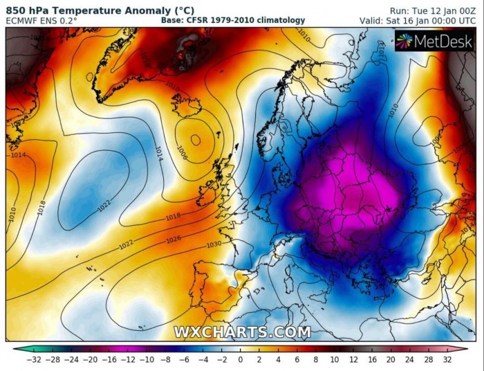
The powerful cold advection continues also over the weekend, with actually a pretty extreme temperature anomaly. Keep in mind we are at mid-winter month, January, so 12-15 °C below average is extreme! The large cold pool will expand across whole eastern and northeastern Europe and the Balkans, as well as across a large part of central Europe. It also partly expands into the Mediterranean, so temperatures will be much lower there as well.
Colder weather will also spread towards western Europe, but it will be far less significant than it will be in the core of the cold outbreak. Mild weather should also persist over the Iberian peninsula as upper High remains.
WINTER STORMS BRING FRESH SNOW
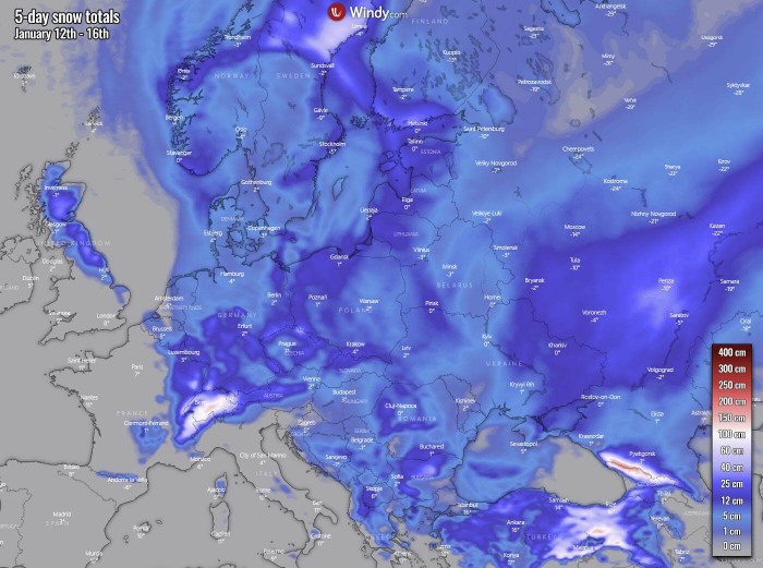
What we want to see is if such a deep core would also promote winter storms and snowfall with accumulation at the end. Attached below is the overview of the total snow accumulation over the next five days, this means from Wednesday through Monday morning, so basically in relation to this significant upper core evolution timeframe. As we can see, a large part of Scandinavia, eastern and southeastern Europe, including the Balkans, Central Europe, and the Black Sea region could receive some good amount of snow locally.
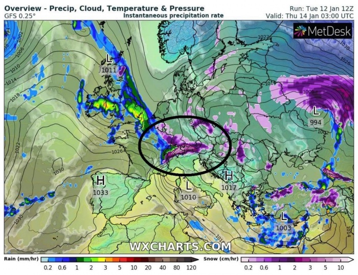
The frontal system moving south with the strengthening upper low on Wednesday will promote a winter storm development across southern Scandinavia and Denmark into eastern Germany, western Poland, and towards Czechia further south towards the Alps by Wednesday night. While the amount of snow is not expected to be particularly deep along with the storm, the surface low and frontal system will be quite organized and snow squalls are expected along with the leading front racing south during the days. With snow showers behind it, thanks to much colder air mass advection in the storm’s wake.
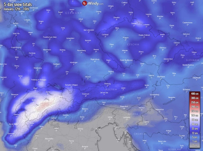
But in response to this Wednesday’s winter storm, a huge amount of snow is expected along the northern Alpine flank. The textbook orographic precipitation event with the persistent, strong north-northwestern flow in the wake of the frontal system advects high moisture into the northern Alps. Therefore introducing intense orographic snowfall and lead to high snow amounts in about 36-48 hours. It appears likely that most of the snow will fall across northern and western Austria and especially Switzerland, locally close to 1 meter of fresh snow is quite likely.
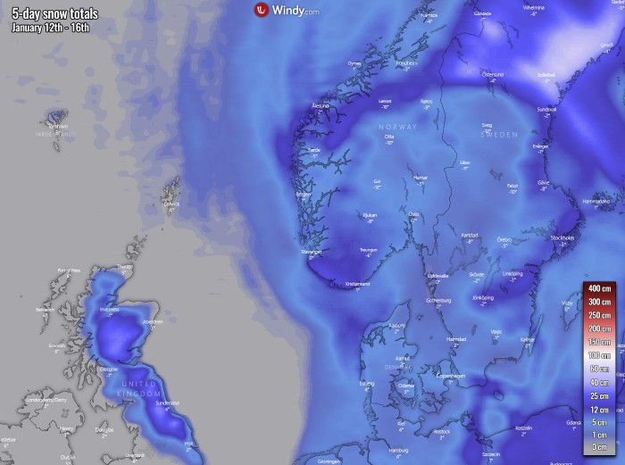
As the core of the deepening upper low travels south across northern towards eastern Europe, it also supports snowfall over Scandinavia. Some snow accumulation will also be possible across while region, including Denmark, northern Germany, and indeed Poland and the Baltic countries. Might even temporarily snow across northeast England, easily across the Scottish Highlands. The highest amounts are, however, also likely across north-central Sweden, thanks to the moisture advection from the Baltic region beneath very cold mid-levels.
The second winter storm this week is expected to develop across Turkey and the Black Sea region on Friday, quite rapidly moving east. It is a response to the deepening of the upper core aloft, supporting surface depression over the Mediterranean moving east along the southern flank of the cold outbreak. It will actually be related to the main frontal system coming up over the Balkans and the northern Mediterranean, but it re-intensifies when meets warmer air mass further south.
When the storm arrives in Turkey, heavy snow with dangerous blizzard conditions is expected on Friday, gradually moving into Georgia through Friday night into Saturday. Heavy snowfall over the Alps finally vanished as northwest flow weakens.
The Turkish winter storm will bring an impressive amount of snow especially across eastern Turkey and indeed over the Greater Caucasus. 75-100 cm or even more locally is certainly possible over the weekend there, enhancing avalanche threat into the valleys around. Some fresh snow is also expected across most of the Balkan peninsula, the most probably over Bulgaria.
Actually, the whole region affected by the deep upper trough/low will experience some winter weather, both from occasional snow to very cold days. And especially extreme cold mornings with high potential to push minimum temperatures even below -20 °C, thanks to the relatively dry continental air mass.
PATTERN SHIFTS INTO WINTER MODE NEXT WEEK
What is shaping up afterward is surely an important trend to monitor. There is a quite impressive consistency of both global models, ECMWF and the GFS, regarding how the pattern evolves after the Polar Vortex collapse from earlier this month. Trends are turning into an increasing potential for winter weather to develop, possibly over a large part of the European continent.
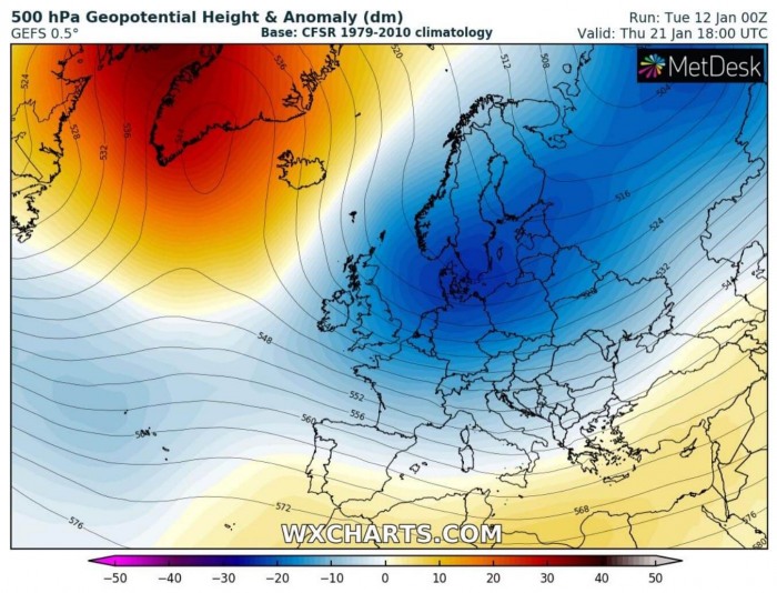
We are looking over the ensemble model forecast of the ECMWF model first. ECMWF-ENS has a strong upper-level blocking High over the Arctic region and Greeland, extending the ridge down south over the North Atlantic. While a very large, long-wave, and deep trough dominates Europe.
Now, let’s take a look over the ensemble GFS model, shortly the GEFS. We can see there is barely any significant difference against the ECMWF chart above, actually. So we can have quite high confidence that such a pattern evolution is now becoming increasingly likely into the second half of January.
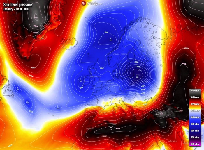
Such a pattern evolution plays an important role in the potential of winter weather developing across the European continent next week into the rest of January. In response to a very large and deep trough strengthening over Europe, also surface pressure falls. From the ECMWF pressure chart below we can see how an extensive surface depression is trapped in between blocking high-pressure systems. One continues over Greenland, while another one is elongated from the Mediterranean into western Russia.
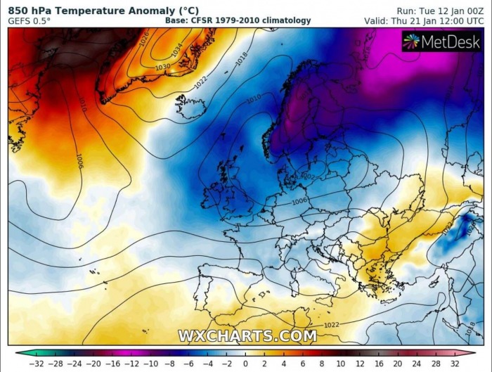
As we can see, a very large part of the European continent is dominated by an extensive surface low-pressure system, while higher pressure over Greenland hints at how the flow will behave. The strongly meridional (northerly) flow will keep the advection of an Arctic cold air mass into the large surface depression over Europe, so the temperatures will be much lower than normal. It will first be extremely cold over Scandinavia, but then also further south into western and towards central Europe throughout late next week.
A low-pressure system also means that parts of Europe are in for snowy weather for sure, as more moisture will be in place. Even some significant winter storms are possible. We are further monitoring the evolution of the developing pattern and will be covering these winter events in the coming days and over the weekend.
Stay tuned!
***The images used in this article were provided by Windy, Wxcharts, and NOAA.
