The snowfall predictions for Winter 2025/2026 show a strong cold and snow pattern across the United States and Canada. This is already evident in the current daily weather, with a growing cold air anomaly. Across the Atlantic, Europe shows a slow start to the snow season.
The main global weather driver in the upcoming winter season is expected to be La Niña. In recent days and weeks, we have been tracking a developing Stratospheric Warming event, which has impacted the winter polar vortex and daily weather.
Looking at global long-range weather forecasting systems and historical data, you will see snowfall predictions for the upcoming Winter and how they are influenced by these large-scale factors.
WINTER STARTS WITH SNOWFALL
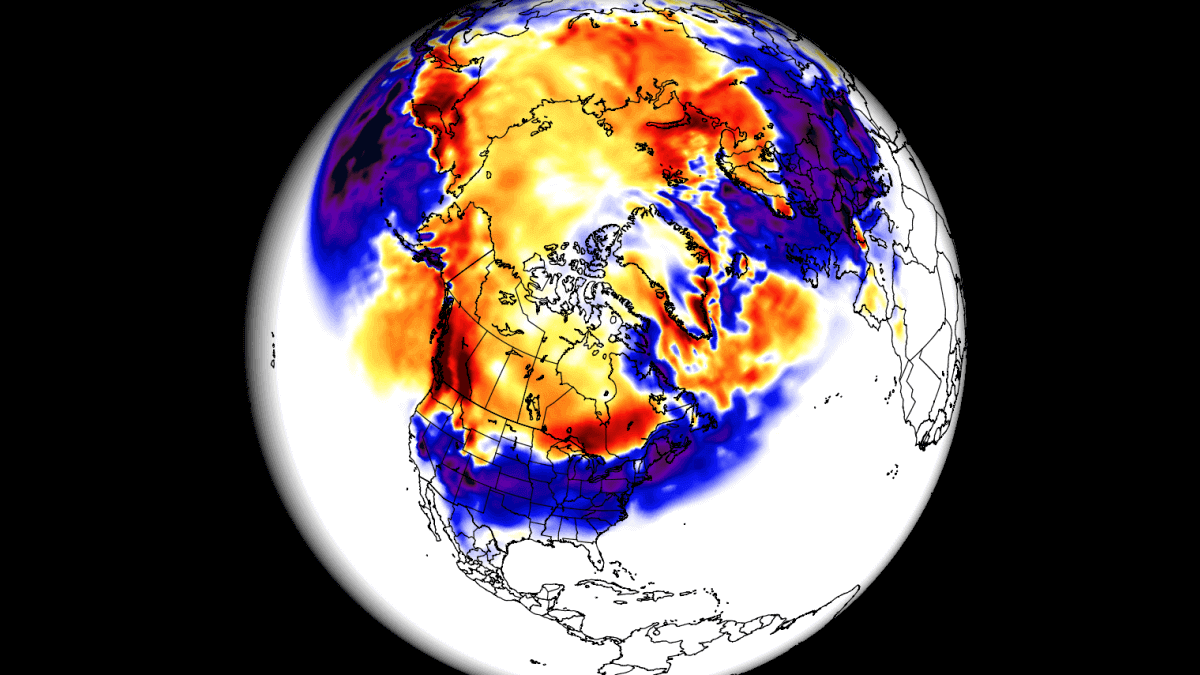
Since we will be talking about the snowfall forecast in this article, we have to look at the current weather pattern across the Northern Hemisphere. Because it just happens that a colder weather pattern is developing right at the start of the meteorological winter.
Meteorological winter began on December 1st in the Northern Hemisphere and will last three months, ending on the last day of February.
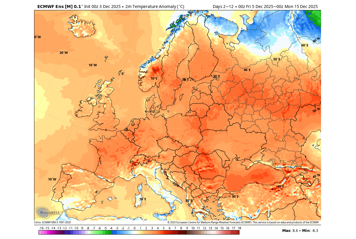
In the image below, you can see the pressure anomalies for the first half of December. A large area of strong low-pressure anomaly is forecast over Canada and the east-central United States. This is the core of the Polar Vortex, and also causes higher pressure to build over Europe.
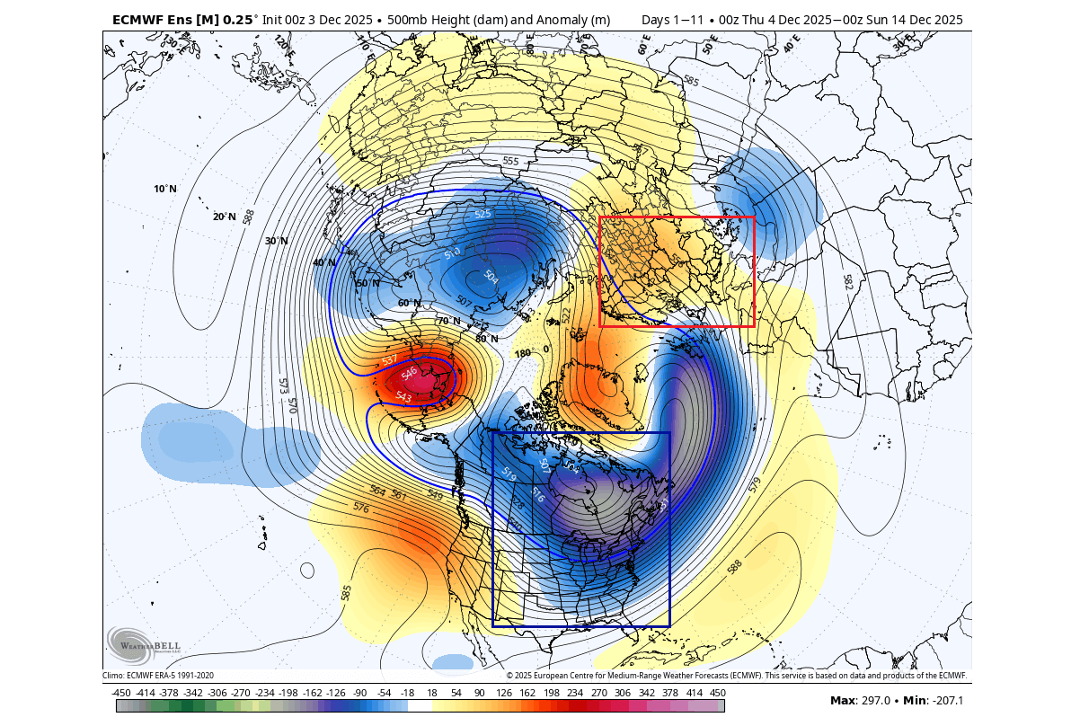
The low-pressure Polar Vortex core brings a sustained cold air flow into the central and eastern United States and southern Canada. At the same time, a westerly to southwesterly flow is established over Europe, bringing mild conditions and unsettled conditions over the northwestern parts.
This is reflected in the temperature forecast over North America for the same period. It shows a strong corridor of colder air, spanning from the Arctic Circle into southern and eastern Canada and the eastern half of the United States.
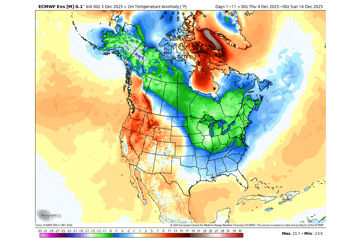
This is the effect of a low-pressure system positioned over Hudson Bay, as it spins counterclockwise, creating a strong northerly flow from Canada into the United States.
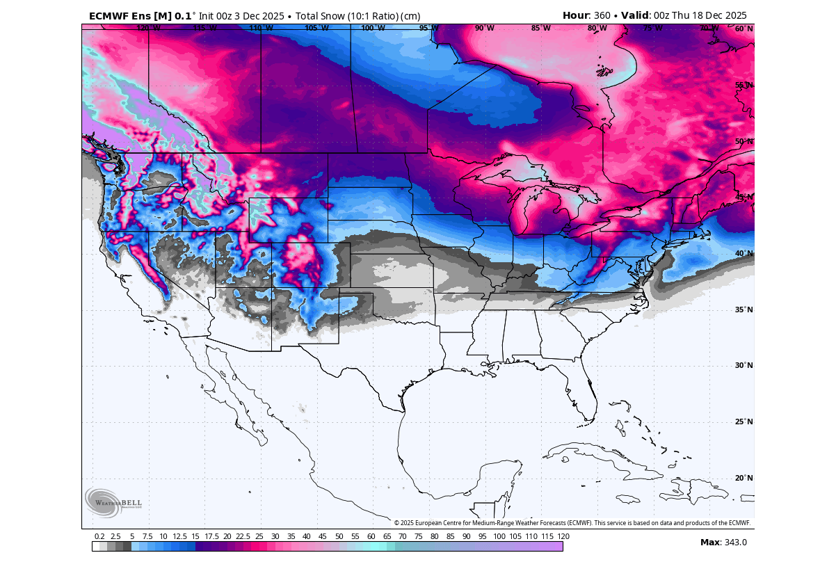
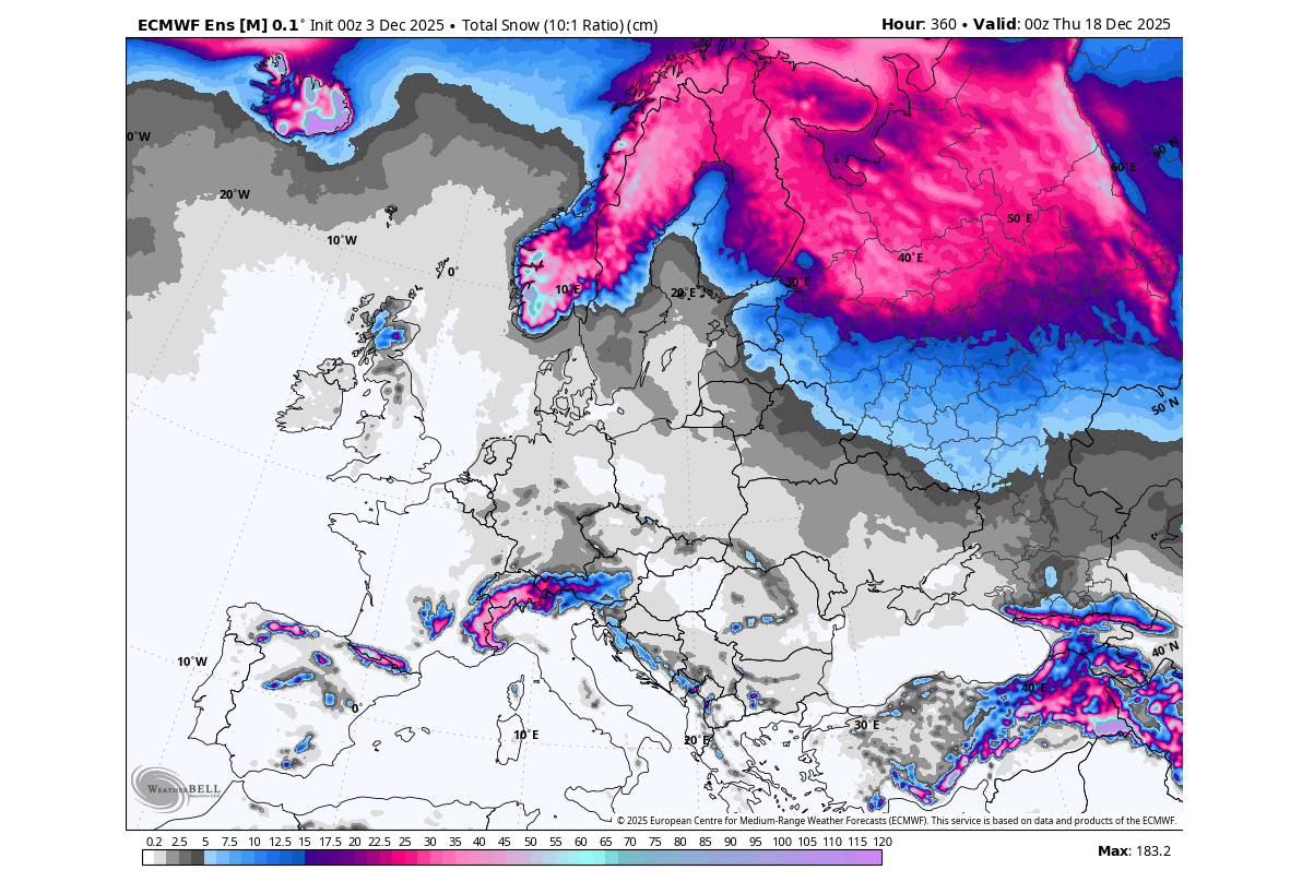
Looking at the total snowfall forecast for the first half of the month, you can see quite a large area with expected snowfall. For example, the western United States across the Rockies and some lower elevations, parts of the Midwest, the northern and central Plains, and a larger batch over the Midwest and the northeast.
Over Europe, mostly normal to above normal temperatures are forecast for the first half of the month, driven by the westerly to southwesterly flow. This brings a mild pattern into the continent, with the cold air supply cut off, or pushed far north.
Looking at the snowfall forecast for the same period, you can see mostly higher-elevation snowfall. This is expected, as there is a lack of cold air to drop the snowfall level down to the lowlands.
These current events are just one example of how quickly the weather pattern can turn wintery across the United States or Europe, despite what a long-term average forecast might suggest. In this case, the winter luck is on the side of North America. But what do the snowfall predictions say for the rest of Winter 2025/2026?
WINTER 2025/2026 SNOWFALL PREDICTIONS
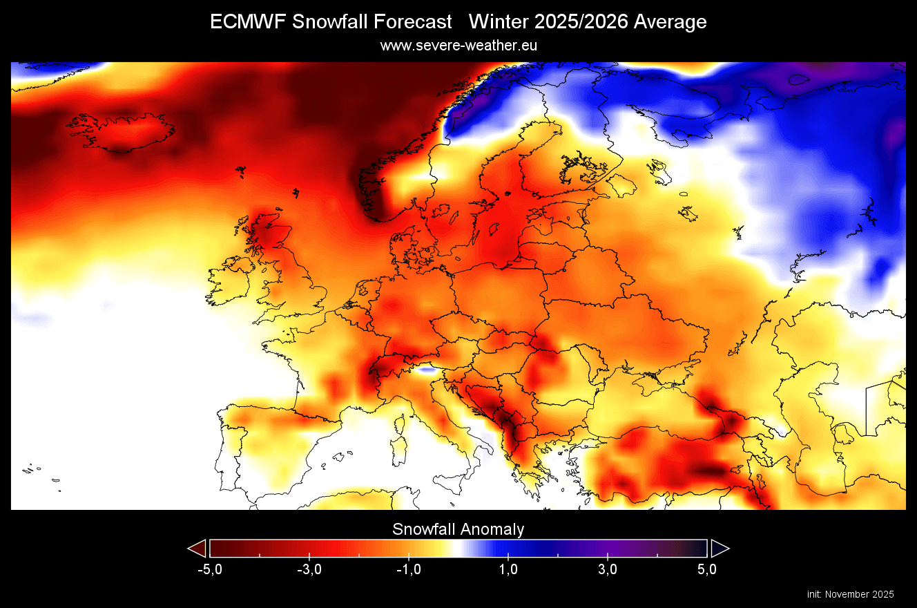
Below is the average snowfall forecast for the meteorological Winter season, covering the December-January-February period. We will do a monthly breakdown, as there are a lot of details in the monthly forecast that the whole seasonal average cannot show.
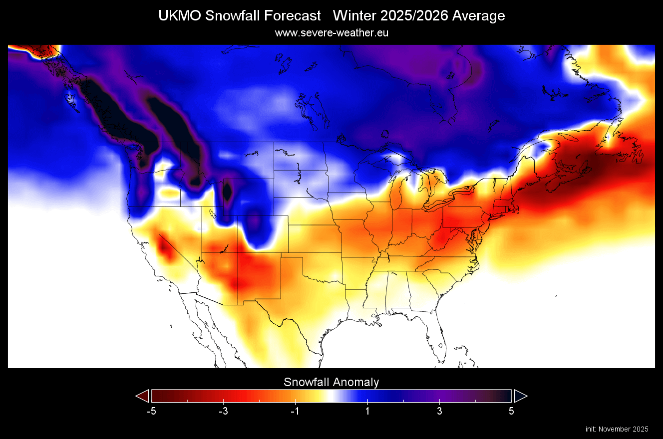
First, looking at the seasonal average, we see below-normal snowfall across much of the continent, with the main snowfall areas pushed towards the north. But you can see some central and western areas that show a lower snow deficit.
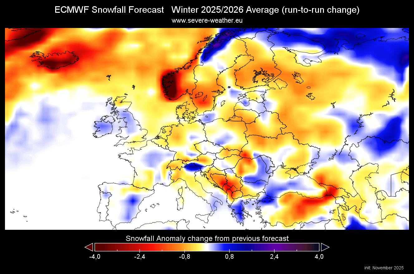
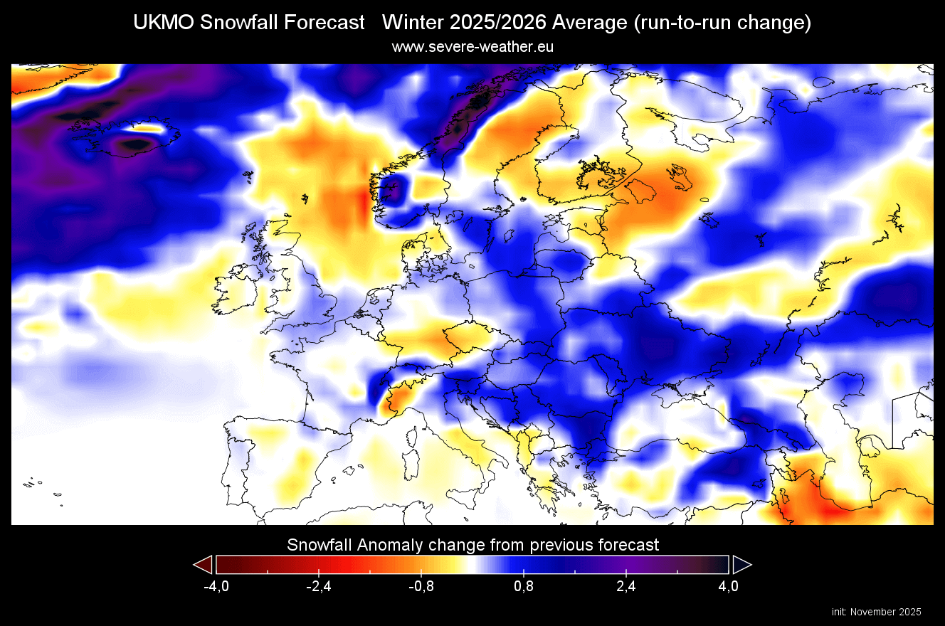
But compared to the forecast data from the previous month, there is some improvement. There is more snowfall now forecast in the latest data over central and west-central parts, and over parts of the UK and Ireland. We don’t see a wild snowfall increase as a result of the stratospheric warming, but the forecast is heading in the right direction with each new run.
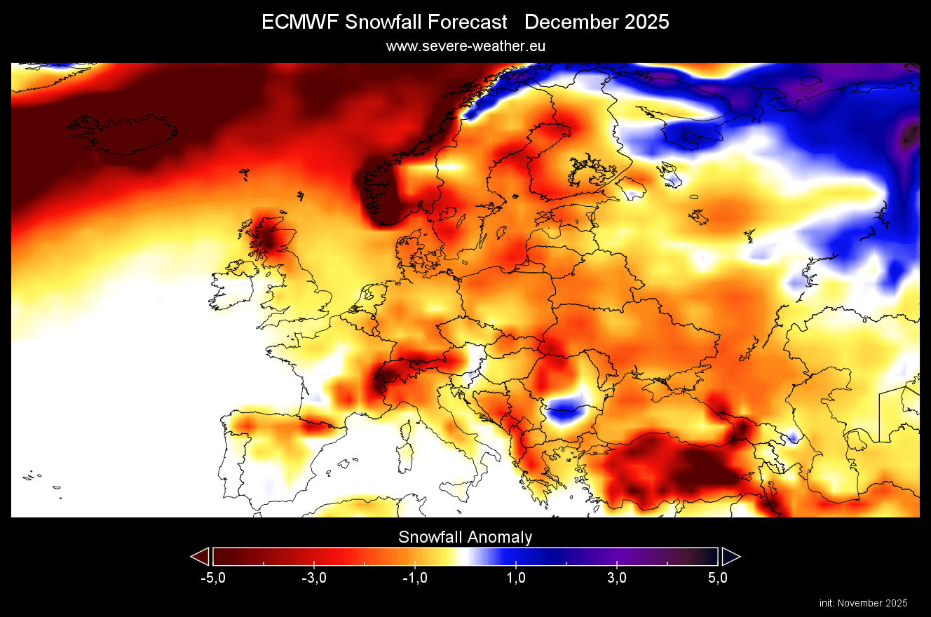
The December snowfall forecast shows mostly negative anomalies, apart from the far north. But we can see that apart from some stronger negative areas, there are zones with lesser deficits. It’s surprising to see less snowfall over higher elevations, indicating more of a low-precipitation problem, rather than warm temperatures.
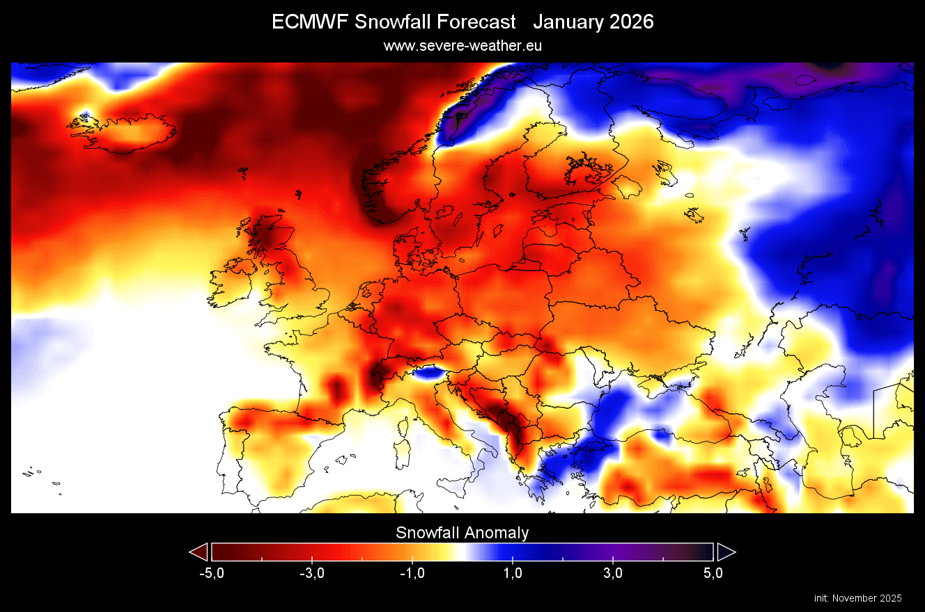
In the January forecast, we don’t see any improvement. Most of Europe is forecast to have less snowfall in mid-winter, but we do see some areas towards the southeast getting more snow in this period, along with far north.
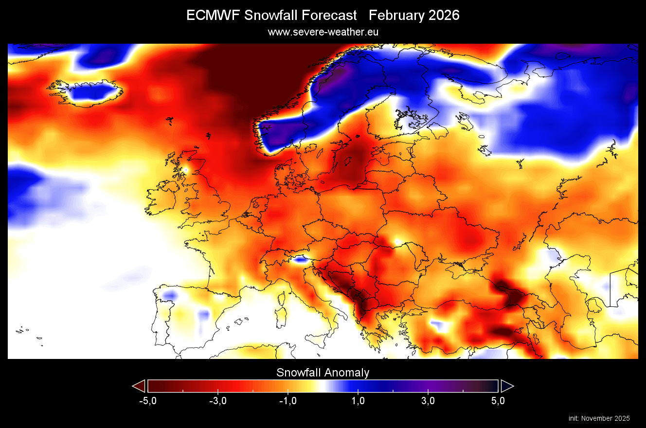
The February forecast shows a bit less deficit compared to the January data. While both months look very poor with snow, the red color does not mean no snow at all. It just shows that less snow than normal is expected.
NORTH AMERICA SNOWFALL PREDICTIONS
Over North America, the southern United States shows below-average snow depth over the entire Winter average. But the latest forecast below is starting to show more snowfall over the whole northern United States and the entire southern half of Canada. This can provide a substantial source of colder air over Canada and also a fixed corridor into the United States.

The deficit (or lack of) snowfall is less over the eastern and northeastern United States and over parts of the lower Midwest.
We can see this more clearly in the run-to-run comparison below. The latest forecast indicates significant improvement, with increased snowfall now projected across the northern United States and the Northeast, and across the eastern United States and into parts of the South. This is something that we can expect to see after a stratospheric warming event, in the mix with ENSO and other tropical factors.
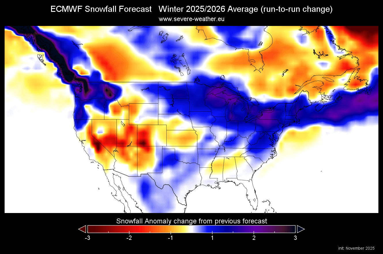
We can also see more snowfall in this forecast over the Pacific Northwest. But there are some areas with less snowfall in this run, like the southwestern United States, the central Plains, and, of course, eastern Canada.
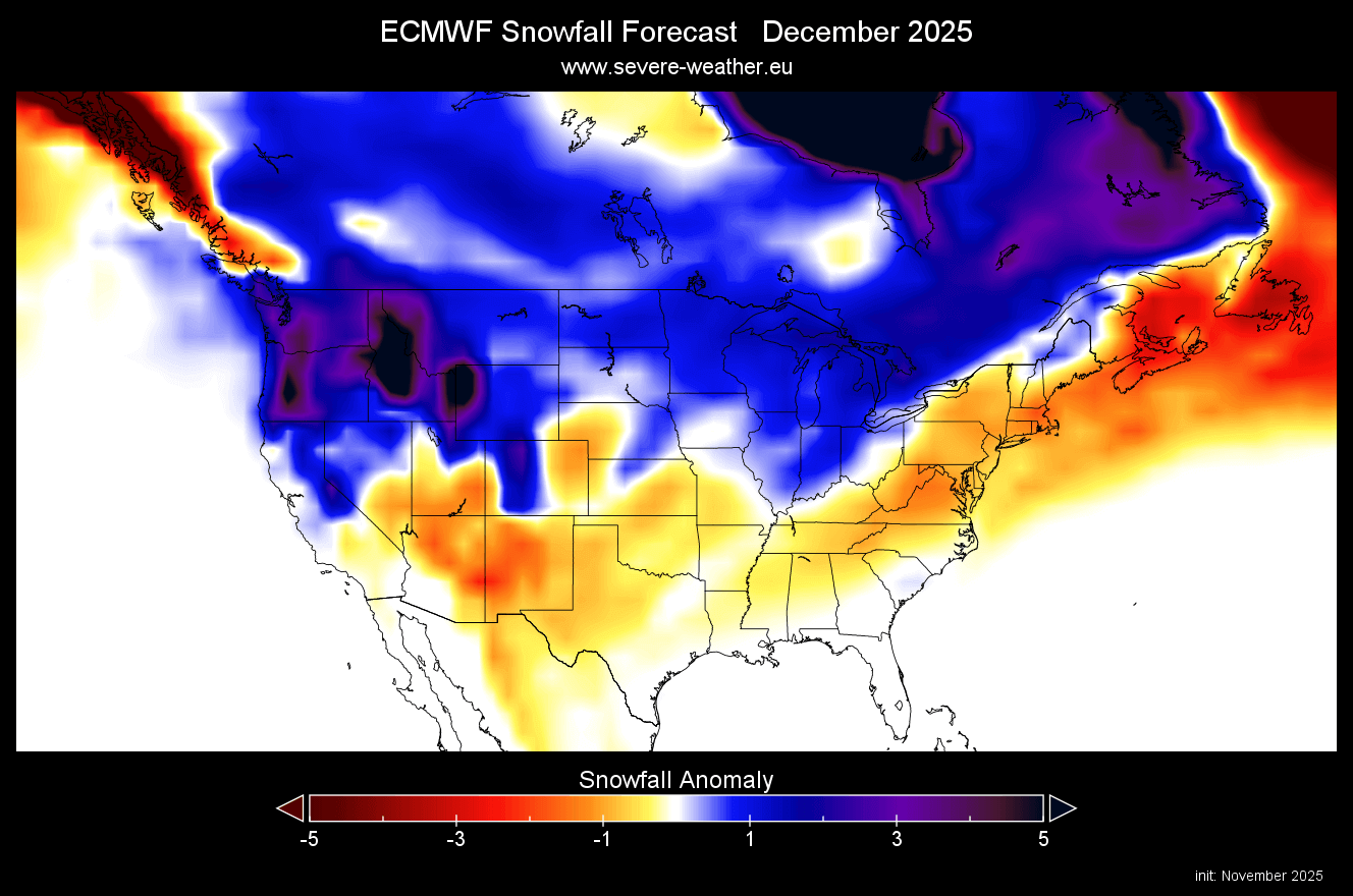
The December snowfall forecast shows less snow cover over the southern parts of the United States. This month shows a substantial increase in snow cover, with above-normal snowfall amounts forecast across the northern half of the United States, but limited over the Northeast.
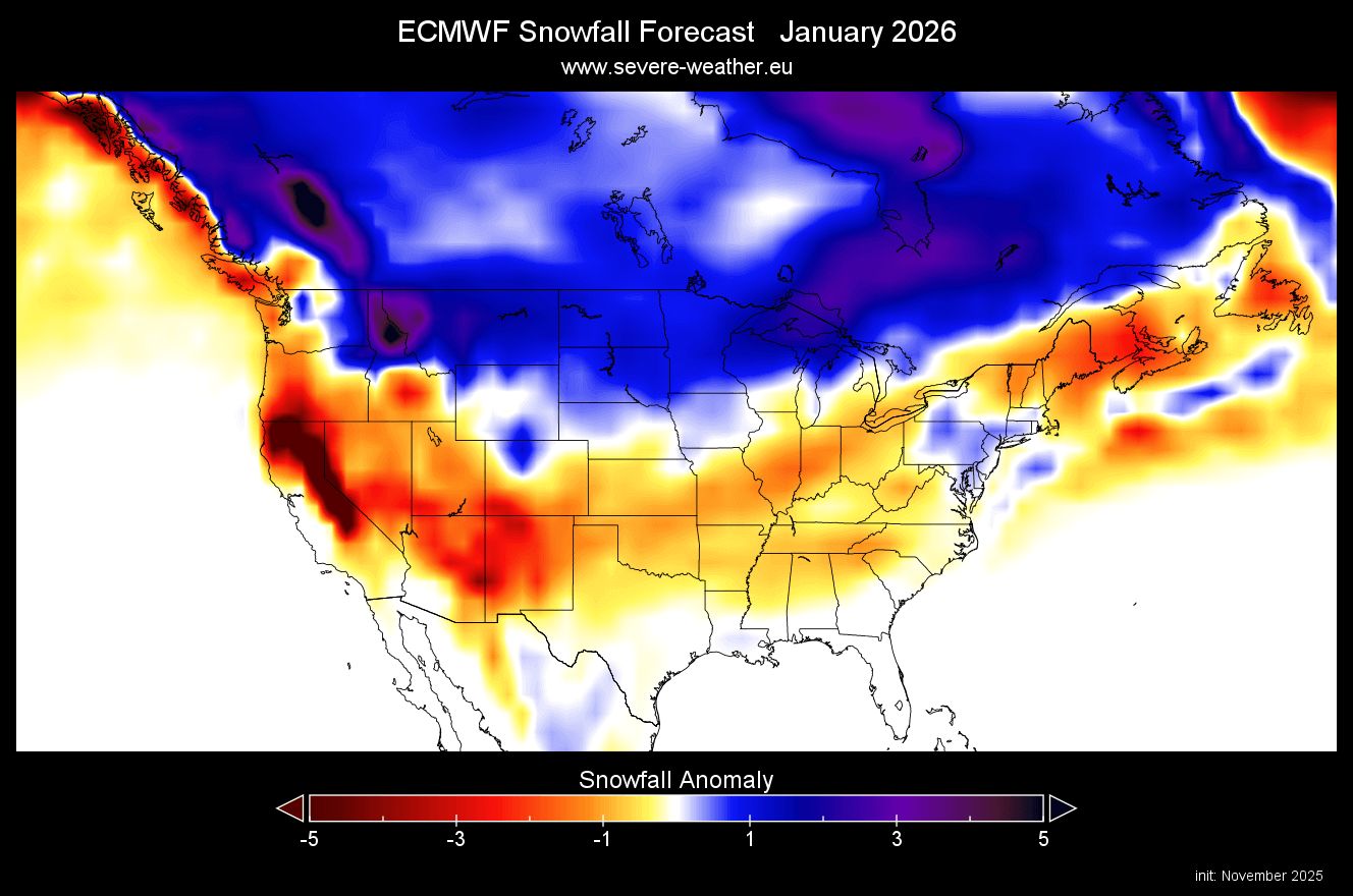
The January snow forecast indicates greater snowfall over the northern United States, the Mid-Atlantic states, and Canada. Less snowfall is forecast over the south-central United States and over deep southeastern Canada. But we do see that the snowfall deficit over the eastern United States is much smaller than over California and the southwest overall.
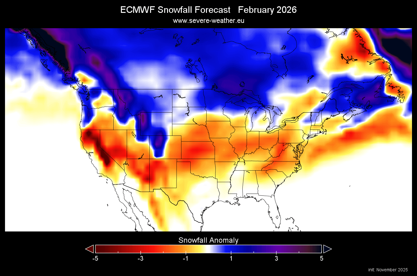
The February snowfall forecast shows the main snowfall area to pull more to the north, looking to shift more into a La Niña-style winter. We see more snowfall over the northern United States and the upper Midwest, over the far northeast, and into southeastern Canada. This month is still far in the forecast range, so it can still start to increase the snowfall amounts with each run.
The March snowfall forecast shows the main snow area pulling back north slightly in early Spring, with a now stronger deficit seen over the Plains, the Midwest, and the northeastern United States. More snowfall is still forecast over southern Canada and into the northern United States.
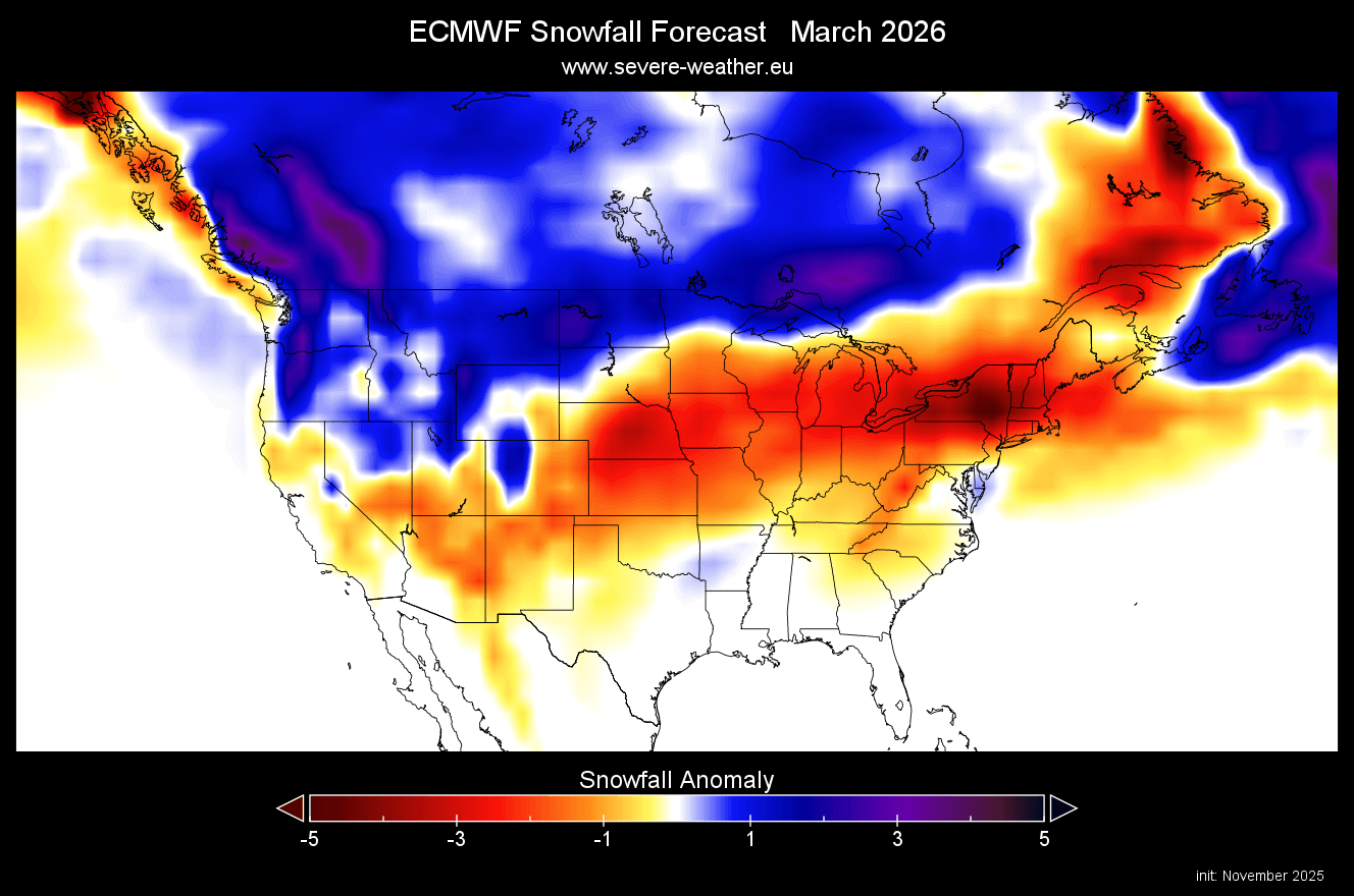
On a side note (just as a fun observation), if you look closely at the image, you should be able to see a pattern of a cat crossing North America.
We were now looking at anomalies, which can only tell us so much. Below is the latest seasonal total snowfall forecast from ECMWF for the next month. It shows the total seasonal snowfall amount and shows legitimate snowfall even over areas that show a snowfall deficit for December.
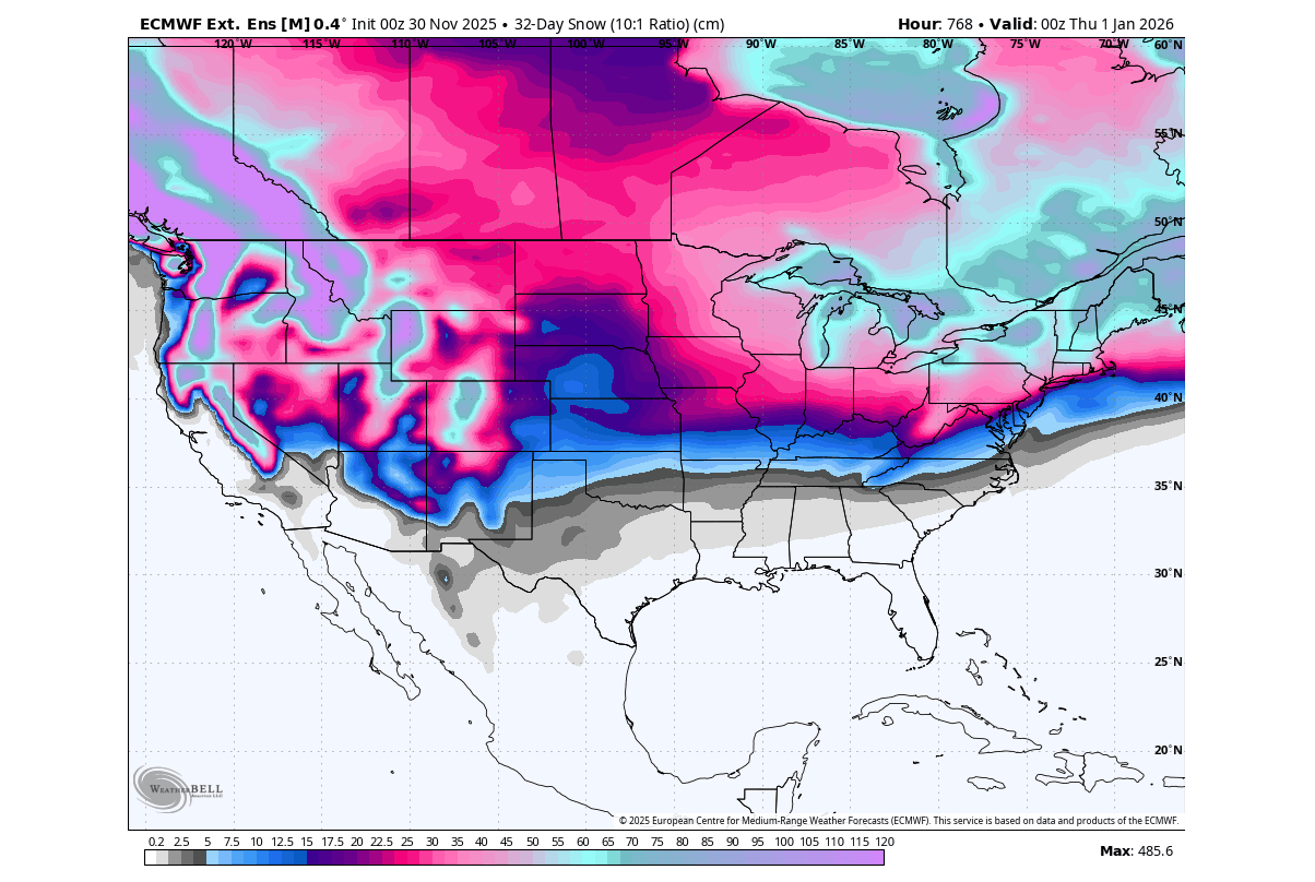
But we do see a good amount of total snow forecast over the Midwest, the northeastern United States, and the West. It is also interesting to see snowfall reach far to the south, which could be a single cold event, but still leaves a mark.
This is a clear sign that while some areas show below-normal snowfall, that does not mean no snowfall at all. It just means those areas are expected to see less snowfall than usual, while still having some snow on the ground during the whole season.
UKMO WINTER SNOWFALL FORECAST
Because you can never trust a single forecast model, we tend to use the UKMO long-range forecasting system as our second forecasting go-to choice.
First, looking at the seasonal average for Europe, we can see a rather weak snowfall forecast, similar to the ECMWF. Most of the continent is forecast to have a below-average snowfall season, except for the far northern parts. In our experience, UKMO tends to be less optimistic about snowfall than ECMWF, so this is to be expected.

The latest run shows much better snowfall amounts compared to the forecast data from the previous month. It is likely that some improvement comes from the current Stratospheric Warming event. Much of the mainland shows more snowfall in the latest forecast, and we can also see improved snowfall over the southern UK.
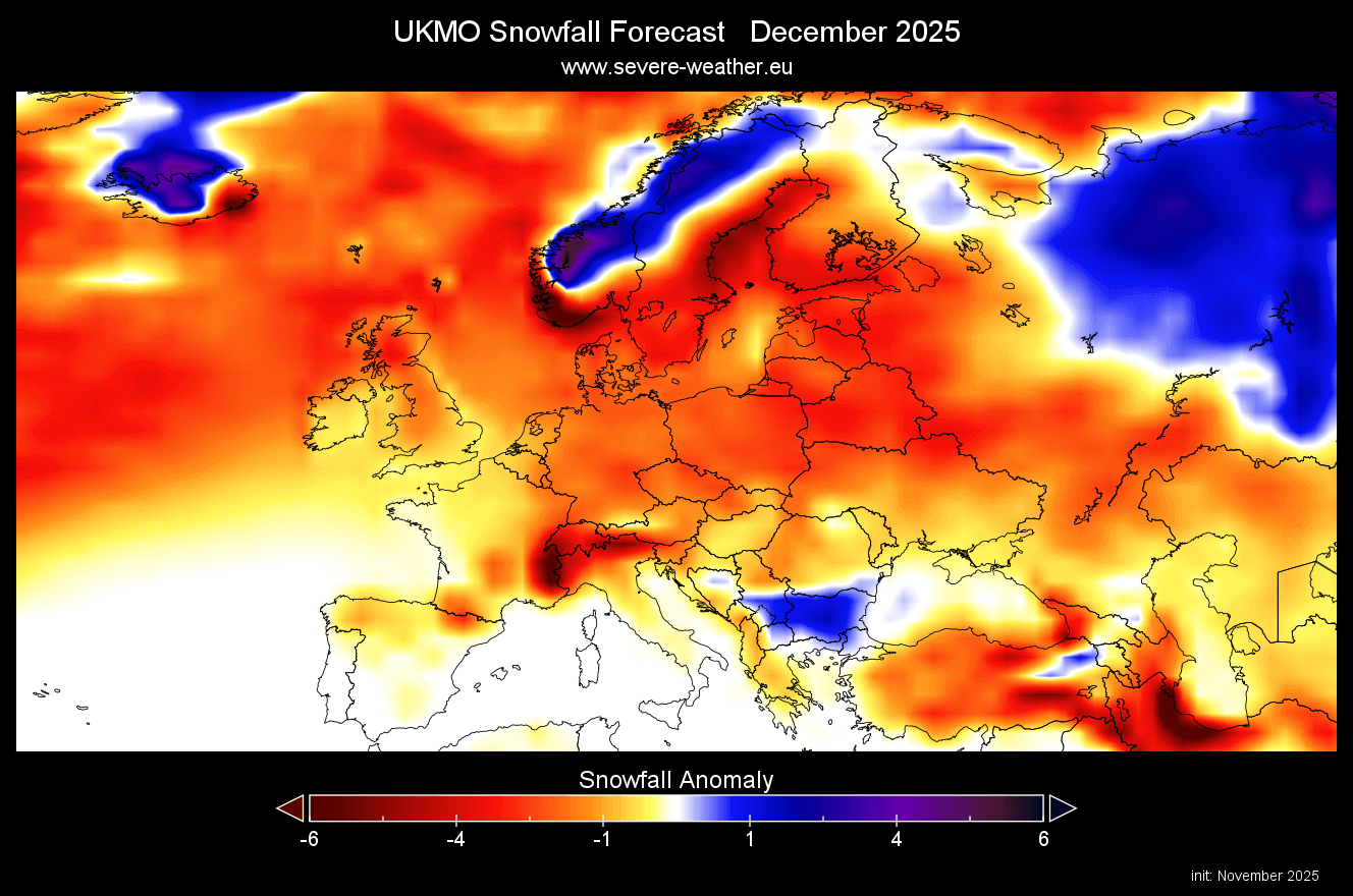
The December snowfall forecast shows stronger negative anomalies, just like the ECMWF. This agreement in both models does give some weight to this scenario, with a slower start to the snowfall season. There are still some south-central and northern areas with normal to above-normal or normal snowfall.
The January snowfall forecast shows some improvement in parts of central Europe, with even some above-normal areas, and lesser deficits over western parts. This suggests that the main problem this month is likely a lack of precipitation, along with milder temperatures.

The February snowfall forecast again reduces snow potential across most of Europe, except for the far north. We still see a lesser lack of snowfall compared to January, so it’s likely there would be more of a single-event snow drop, that’s still strong enough to o

UKMO NORTH AMERICA SNOWFALL FORECAST
The average seasonal forecast for the United States and Canada shows a rather typical La Niña snowfall pattern. We see more snowfall forecast over the northwestern United States, the northern Plains, and the upper Midwest, and over much of Canada. Less snowfall is forecast over the central and southwestern United States, with the belt of less snowfall continuing to stretch towards the northeast.
The UKMO shows a good improvement in snowfall amounts compared to the previous run. You can see more snowfall in the latest data over southeastern Canada, the central and western northern U.S., the southern states, the upper Midwest, and the northwest.
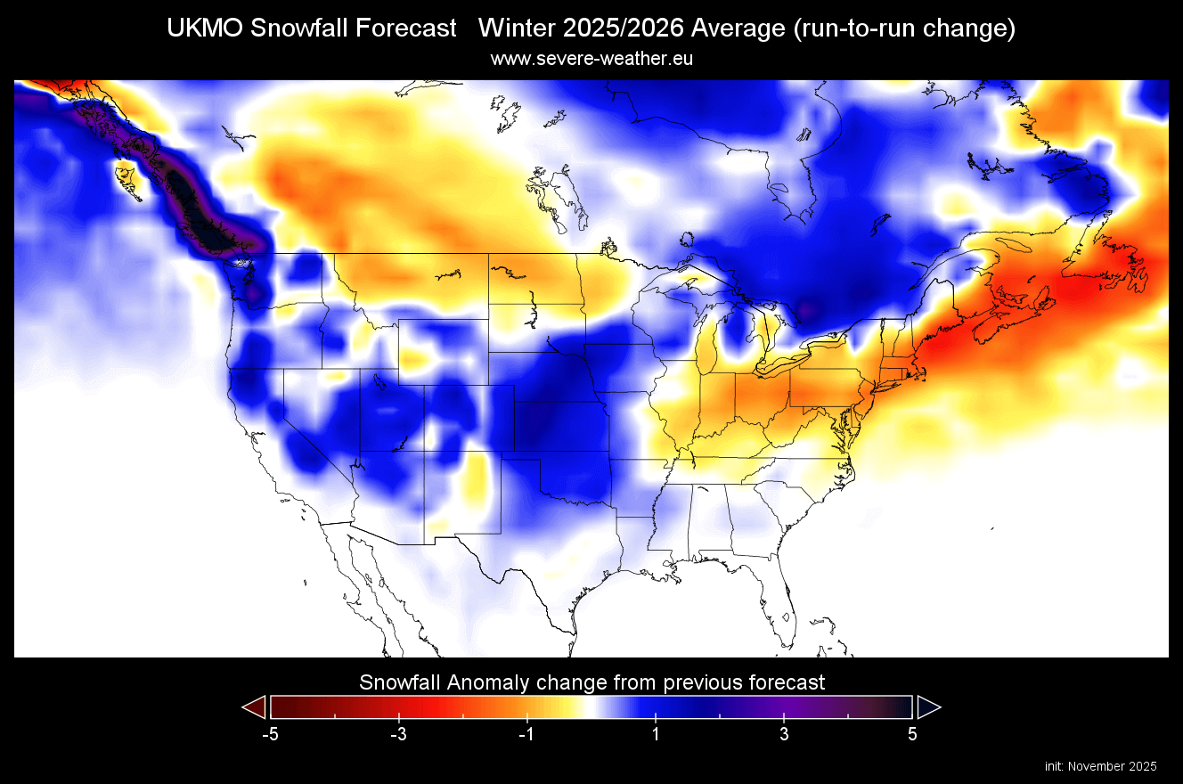
This model run also shows less snowfall over parts of the eastern United States, the northeast, and the far north.
The December snowfall forecast does not seem too optimistic at first glance. But despite less snowfall across the central and eastern United States, there is a larger pool of snow sitting in Canada. That means it is keeping the temperatures lower, so any cold air outbreak that comes from the north is generally colder than usual.
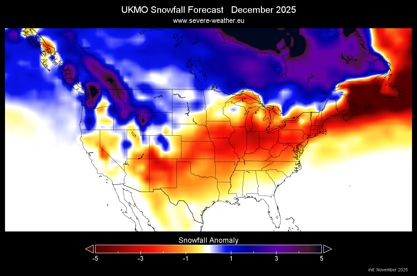
But for snowfall, we also need some precipitation. Overall, we do believe that this UKMO snowfall is not the most optimal, as we already have extended range forecasts that show a different story, combined with the stratospheric warming effect.
January snowfall forecast shows a better pattern across North America, with more snowfall over much of southern Canada and the northern United States. There is still less snowfall shown over the eastern United States, but we can see that the “lack” of snowfall isn ot as great as in December.
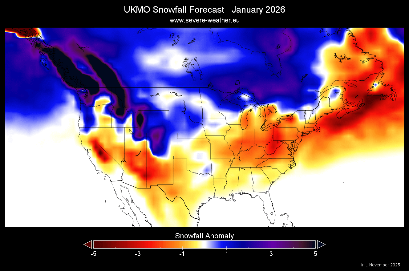
There is an interesting swath of snowfall going across the central to the southern Plains. Considering the amounts, this was likely done in a single event, leaving a mark on the monthly average.
The February snowfall forecast shows another improvement, with above-normal snowfall over much of Canada and the northern parts of the United States, the upper Midwest, and even over the southeast. The only real regions with below normal snowfall are the southwestern United States and the northeast in this forecast.

Otherwise, the rest of the country shows La Niña snowfall patterns, but the UKMO doesn’t seem to properly handle early-season stratospheric warming effects.
Looking at the latest March snowfall forecast, it shows continued snowfall potential over the northern United States and southern Canada in early Spring. The rest of the United States shows reduced snowfall amounts, and in a very (almost unrealistic) sharp pattern.
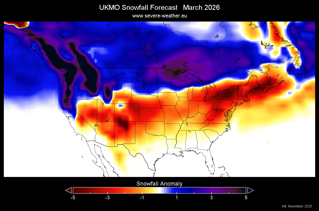
This shows a clear extended snowfall season over the northern United States. With a large mass of snow also in southern Canada, this will prolong the risk of cold air outbreaks into the United States well into Spring.
ENSO WINTER INFLUENCE
The La Niña we mentioned is an ocean anomaly in the Pacific ENSO regions. This is a region of the equatorial Pacific Ocean that changes between warm and cold phases. ENSO phases have a significant influence on tropical rainfall, pressure patterns, and the complex exchange between the ocean and the atmosphere.
Below is the latest surface analysis of the tropical Pacific Ocean, with the marked ENSO area. Cold ocean anomalies extend across the region, creating a cold wave structure due to the easterly trade winds. This is the currently active La Niña, which has reached its peak and is expected to stay within the weak/moderate range.
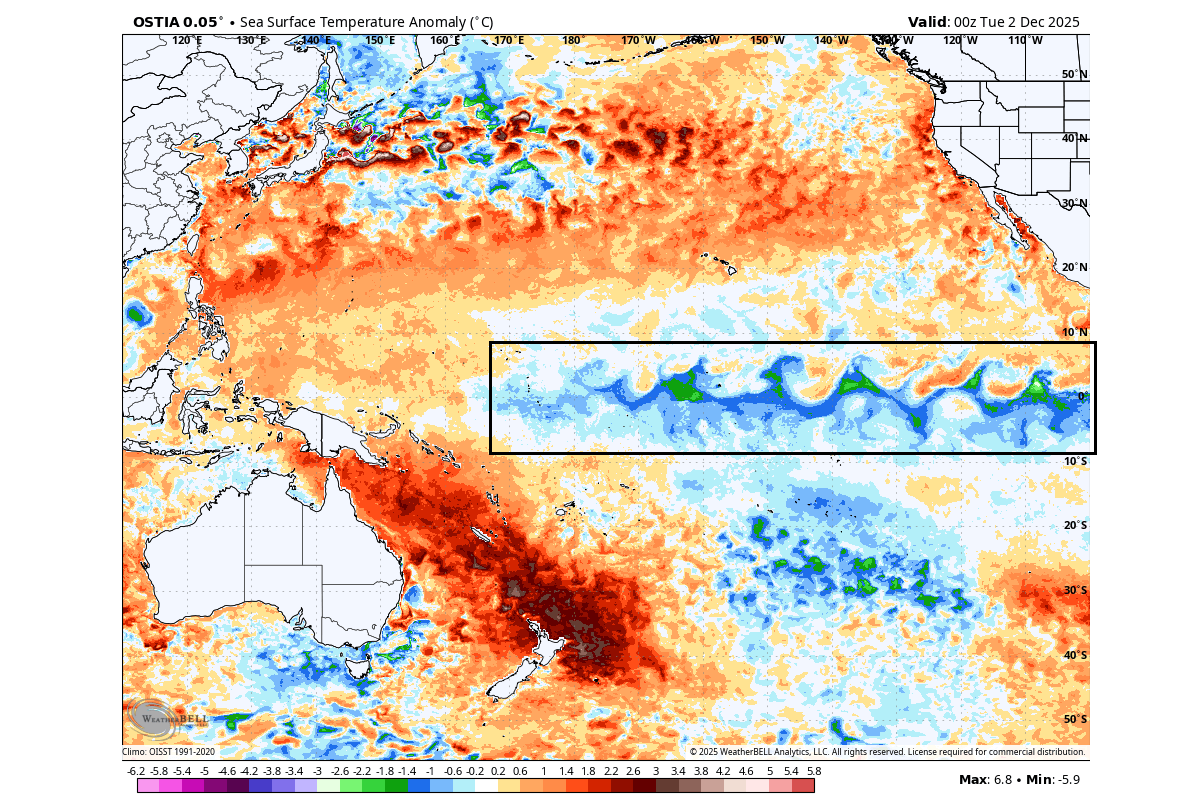
La Niña usually forms during strong trade winds, which can tell us a lot about the state of global circulation. This way, we can use these anomalies as an “indicator” to better understand the current state of the global climate system and what to expect in the seasons ahead.
To better understand these ocean temperature changes, we produced a video showing how La Niña anomalies form and evolve.
The video above shows developing cold ocean anomalies in the equatorial Pacific over the past 90 days. During this time, the trade winds were strengthening, increasing upwelling of deeper, colder waters and creating the now-visible surface cold anomalies.
So what exactly does this mean for the winter weather patterns and snowfall potential? We will take a closer look at the weather influence that La Niña usually brings over North America, where it has a more direct impact.
NORTH AMERICA WINTER WEATHER SYSTEMS
Historically, a strong high-pressure system in the North Pacific has been the most typical feature of a cold ENSO phase. That tends to redirect the polar jet stream down over the northern United States, bringing along a colder airmass.
The image below shows the jet stream redirection during La Niña winters and the resulting weather patterns over the United States and Canada. You can see the high pressure in the North Pacific, pushing the jet stream upwards, with a bend down into the United States, creating a “slide” effect for the cold air.
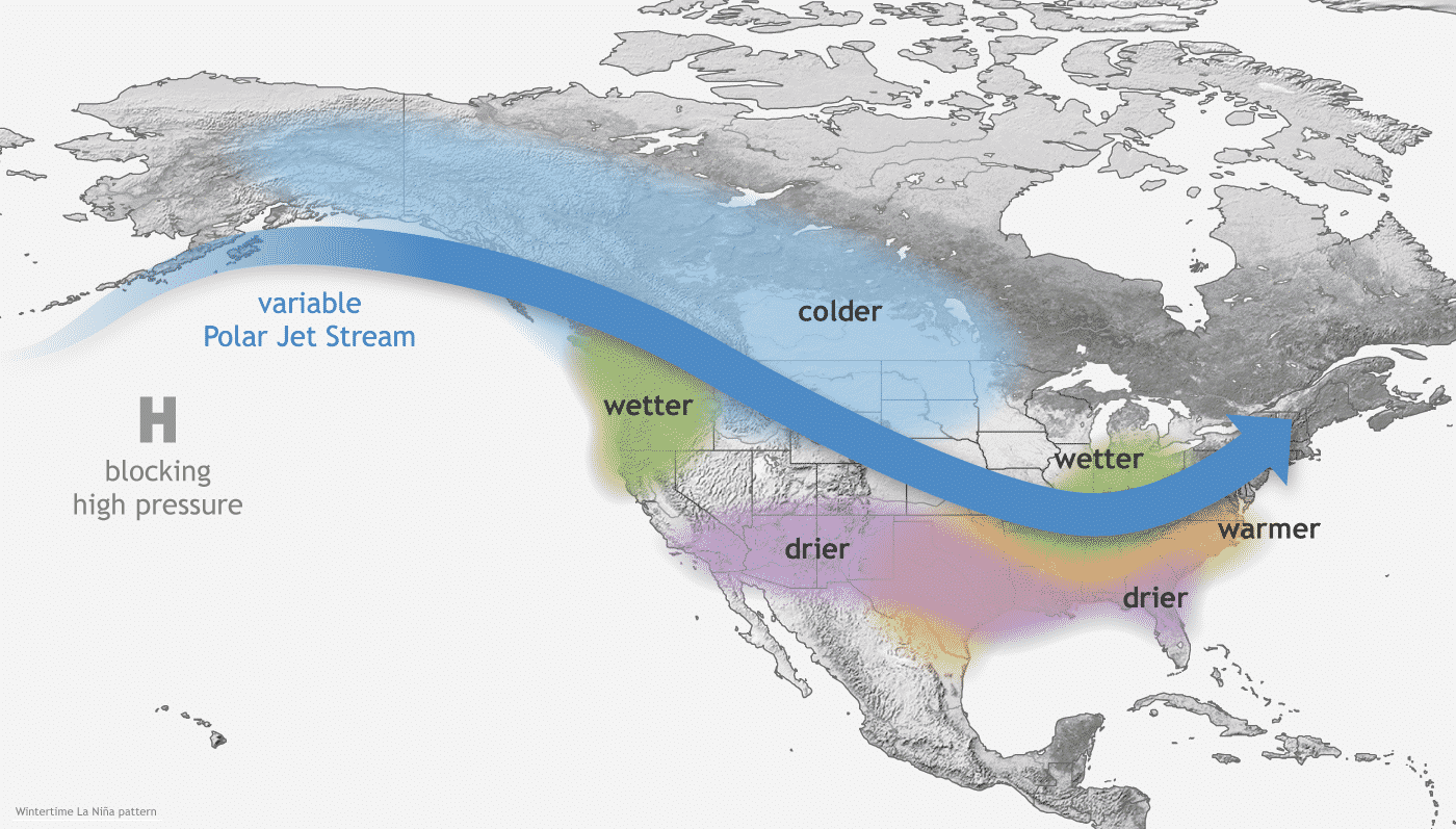
The displaced jet stream brings colder temperatures and winter storms from the polar regions down into the northern and northwestern United States. Warmer and drier winter weather prevails over the southern states.
Looking at the temperature analysis for the weak La Niña winters, you can see the cold anomaly area under the jet stream in western Canada and the northwestern United States. A cooler area extends over the Midwest and down into the south-central plains and partially to the east. We can also see a cooler pattern over Europe.
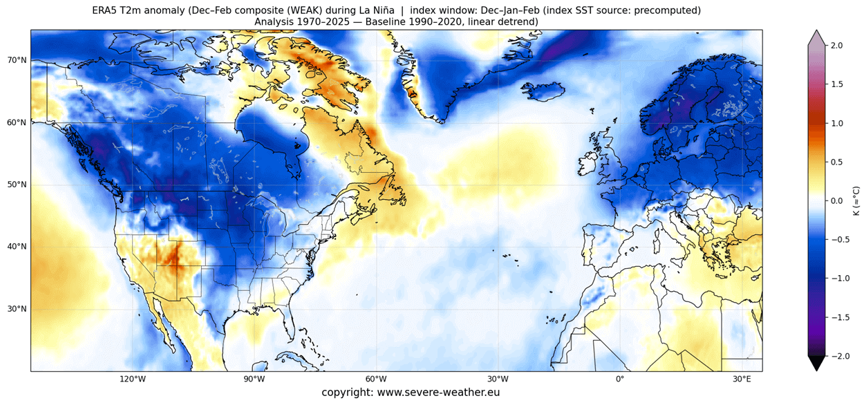
Warmer-than-normal weather and mild winter conditions typically develop over the southwestern United States, parts of the eastern United States, and eastern Canada. This image also shows data from older winters, so it tends to look colder than more recent winters. But it does highlight the impacts and trends.
Because colder air is more readily available over the northern United States, this increases snowfall potential when moisture is available. In the graphic below, you can see the average snowfall pattern for La Niña years, as expected for this Winter season.
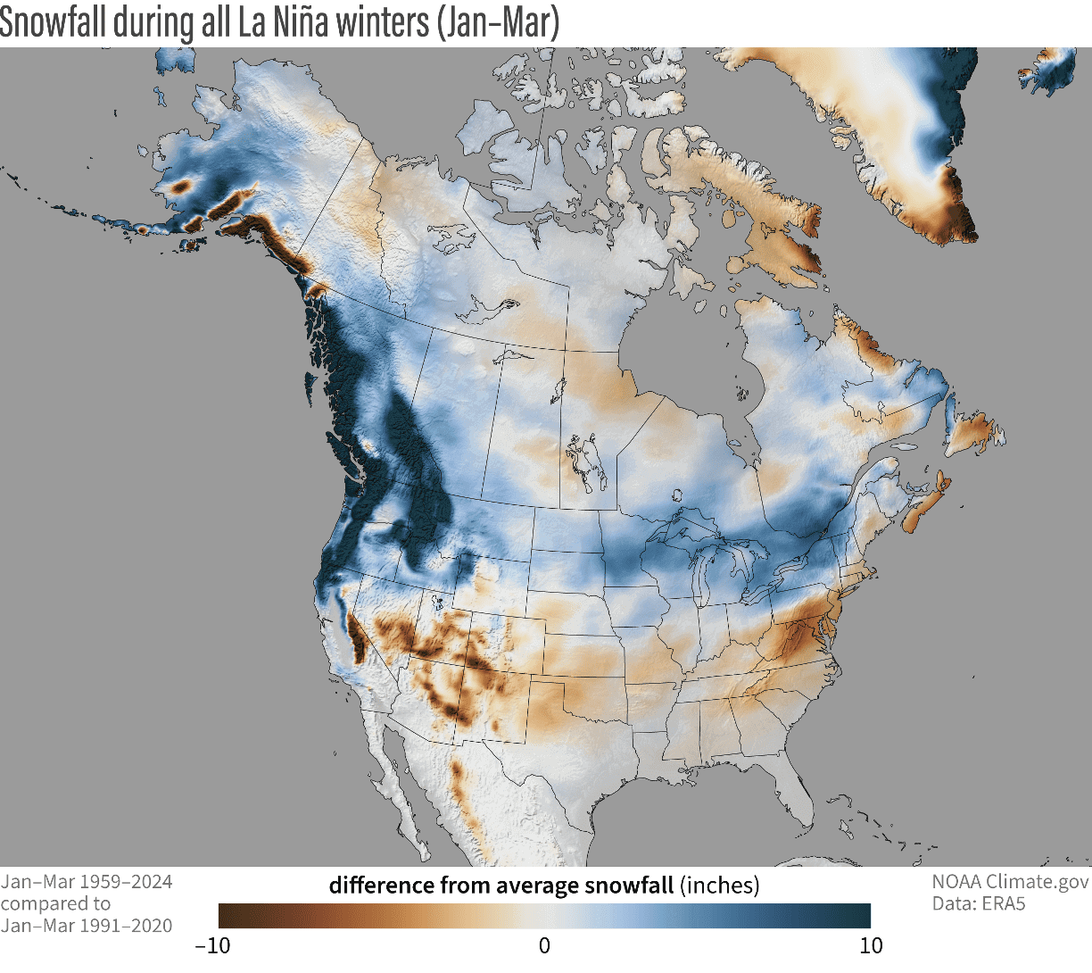
Besides western Canada, the northwestern United States, and the Midwest, you can also see more snowfall potential over parts of the northeastern United States and southeastern Canada.
We will keep you updated on other developing weather trends, so don’t forget to bookmark our page. Also, if you have seen this article in the Google App (Discover) feed, click the like button (♥) there to see more of our forecasts and our latest articles on weather and nature in general.
Don’t miss:
Stratospheric Warming Watch: Polar Vortex to enter North America with cold and snow