New atmospheric data shows strong easterly winds descending through the tropical stratosphere, which could bring notable changes to Winter 2025/2026 across the United States, Canada, and Europe. Known as the Quasi-Biannial Oscillation (QBO), this wind pattern shifts direction every 1 to 2 years and can play a major role in shaping seasonal weather patterns.
Past winters with a similar setup have seen a weakened Polar Vortex, leading to colder and snowier conditions across parts of the United States, Canada, and Europe. Fresh forecasts now suggest that Winter 2025/2026 could be influenced in a similar way.
In this article, we will look at what this wind phase is, its current state, and what the latest long-range predictions already suggest for Winter 2025/2026.
HIGH ATMOSPHERIC WIND ANOMALY
Just like in the oceans, there is a part of the atmosphere that alternates between a positive and a negative phase. But instead of temperatures, we are observing winds, or rather their direction. This is called the Quasi-Biannial Oscillation, or simply QBO.
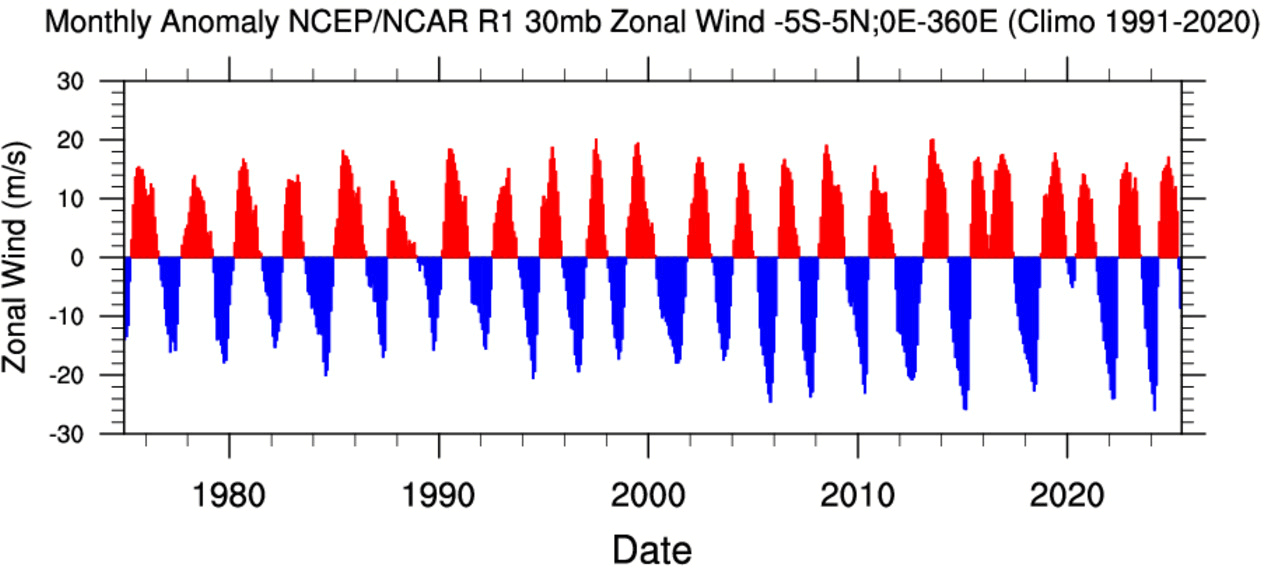
The QBO is a regular variation of the winds high above the tropical Stratosphere, shifting between easterly and westerly (zonal) winds. Strong winds in the stratosphere travel in a belt around the planet at the equator. And around every 17 months, these winds completely change direction.
Below is a graph that shows the zonal wind anomalies for the past 50 years at around 24km/15mi altitude over the Equator. It nicely shows just how regularly this wind shift really is. It is like watching the heart pulse of the atmosphere, which is an often-used analogy for the QBO due to how regular it is.
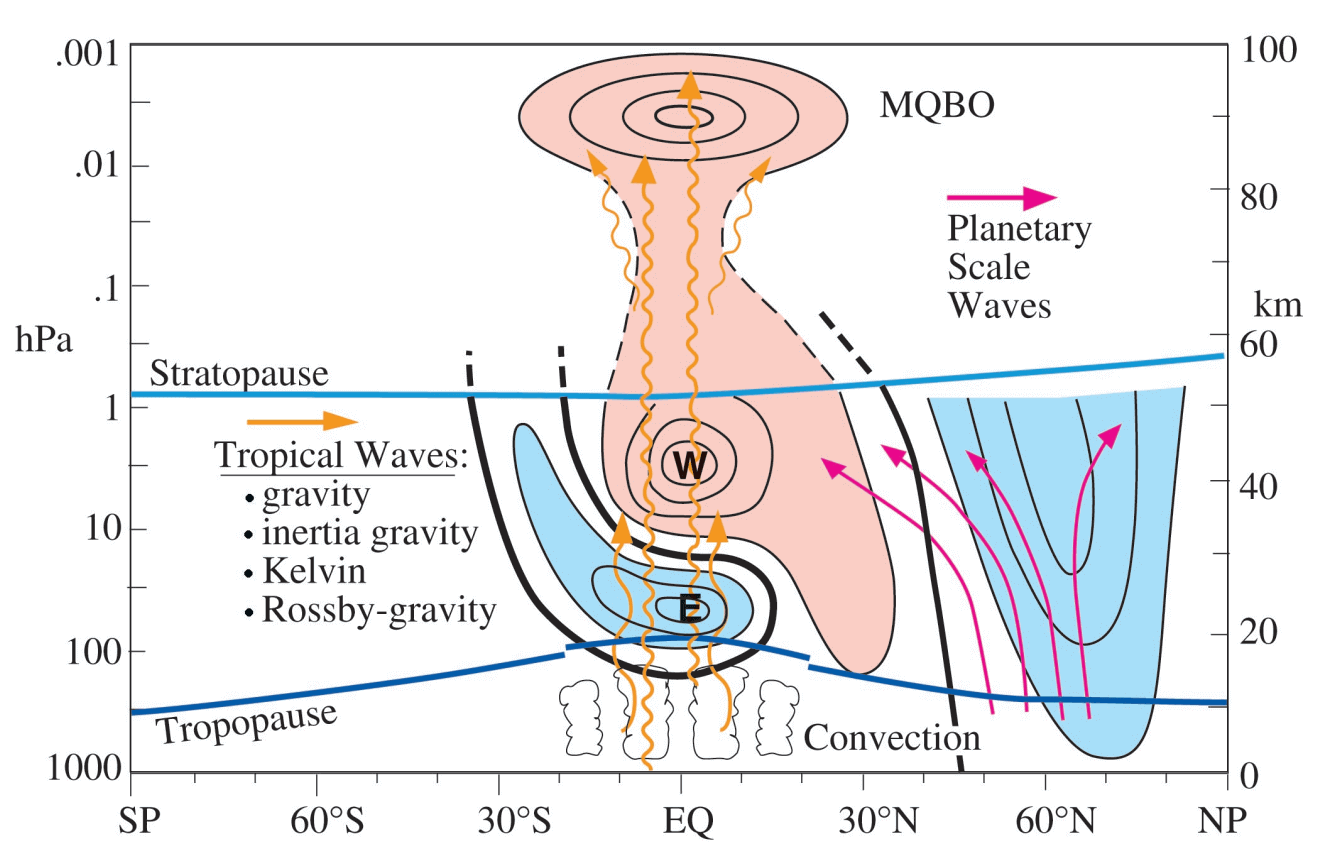
The wind reversal of the Quasi-Biennial Oscillation (QBO) happens because of how atmospheric waves (energy and momentum) from the tropics interact with the stratosphere above. You could say that the QBO is a self-regulating system, but each phase interacts with the whole global weather system.
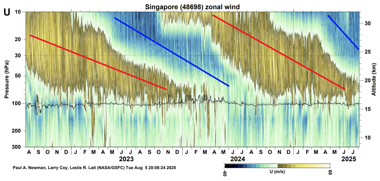
Below is an image that shows the zonal (west-east) wind direction in the tropical stratosphere for the past 20 years. Blue colors represent easterly winds and brown colors show westerly winds. This nicely shows just how the winds are slowly descending through the tropical stratosphere.
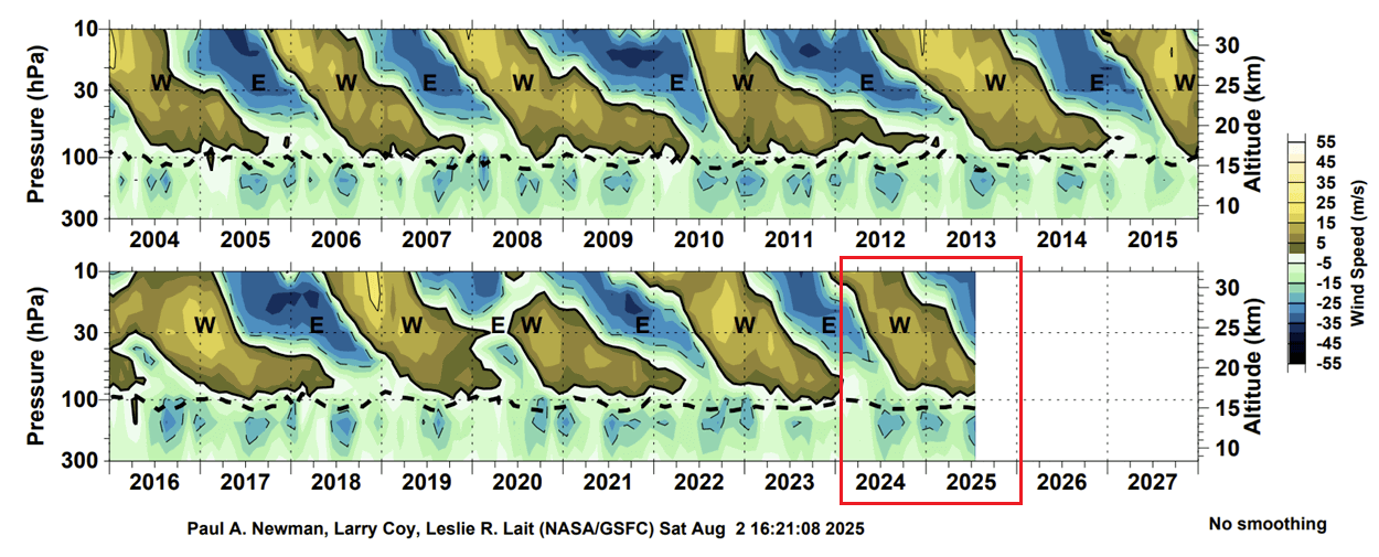
You can also see the latest phase marked in red, and the current descend of the easterly winds. This reveals that a full negative phase will be active for the 2025/2026 cold weather season.
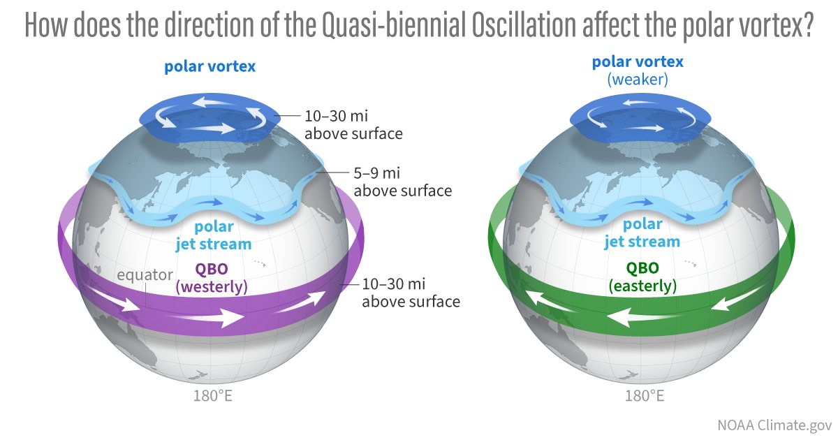
There are several reasons why and how QBO can influence our winter weather. One very important aspect is, of course, the Polar Vortex, which is why we mainly monitor the QBO when it comes to winter. The image below shows the connection between the QBO and the Polar Vortex in the December-January winter period.
It might seem complicated, but the main takeaway is that the QBO is deeply connected to the atmospheric circulation and is linked to the overall tropical forcing, including the ENSO in the ocean below. You could say that it can also help with the “communication” between the ocean and the Polar Vortex.
During an easterly QBO, the stratospheric wind profile is more favorable for the upward propagation of planetary (Rossby) waves from the troposphere into the stratosphere. That disrupts and weakens the Polar Vortex, making it more prone to collapse and disrupting the weather patterns below.
We will show more connections between the QBO, Winter, and the Polar Vortex further down. But first, let’s look at the latest conditions of the descending easterly winds.
A NEGATIVE PHASE DESCENDS
If we look more closely at the past 3 years, we can better see how each phase descends over time through the stratosphere. A negative/easterly phase was active in 2023/2024. It was followed by another positive QBO phase last winter. Currently, a new easterly phase is descending from above for winter 2025/2026. The image below is from a NASA analysis.
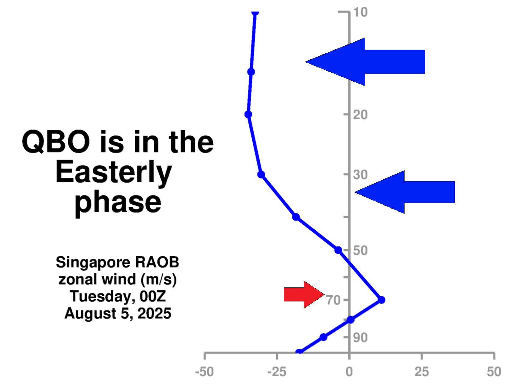
A daily radiosonde analysis from Singapore also shows the wind direction directly above the tropics. The latest data reveals easterly winds around the 10-50mb level, confirming the easterly/negative QBO phase is currently active and descending. It will continue to strengthen and stabilize around the 30-50mb level (21-24km or 13-15miles) as it descends towards winter.
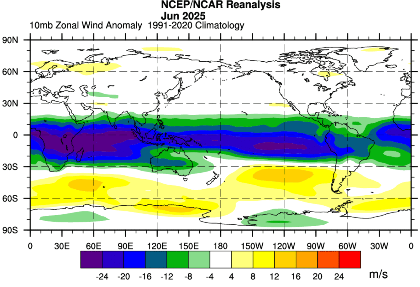
Looking at the latest global zonal wind analysis at the 10mb level (32km/20 miles), we can see the easterly wind anomaly over the equator. This directly reveals the east/negative phase of the QBO, and also shows its overall size. It covers the whole tropical region, while its weather role has a global reach.
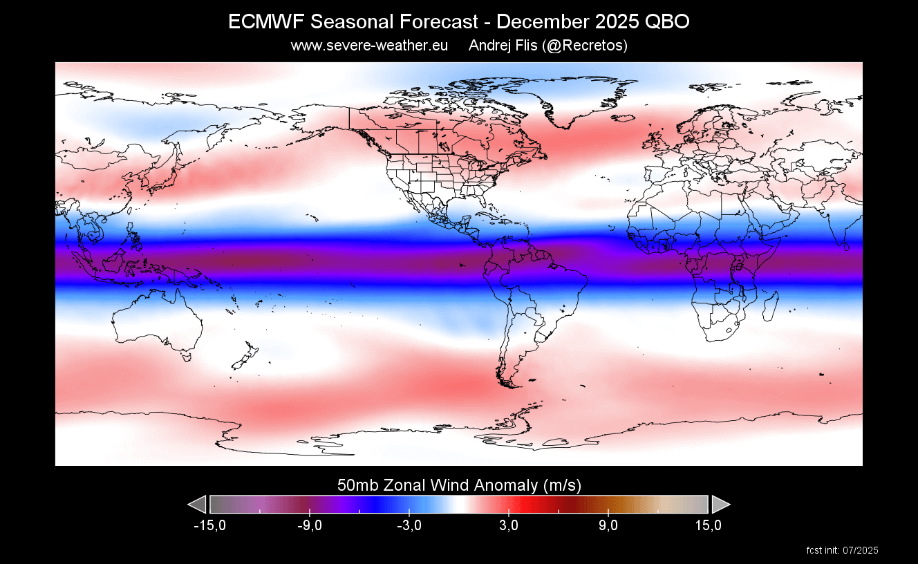
It takes time for each phase to descend through the stratosphere. Below is the latest long-range forecast for December 2025, which shows the wind anomaly at the 50mb level (21km/13miles). You can clearly see a stable and active negative anomaly of the easterly QBO active over the Winter 2025/2026 season.
This gives us confidence to expect winter weather impacts from this wind anomaly, starting with the stratospheric Polar Vortex. But what really is this Polar Vortex?
WINTER, POLAR VORTEX, AND THE QBO
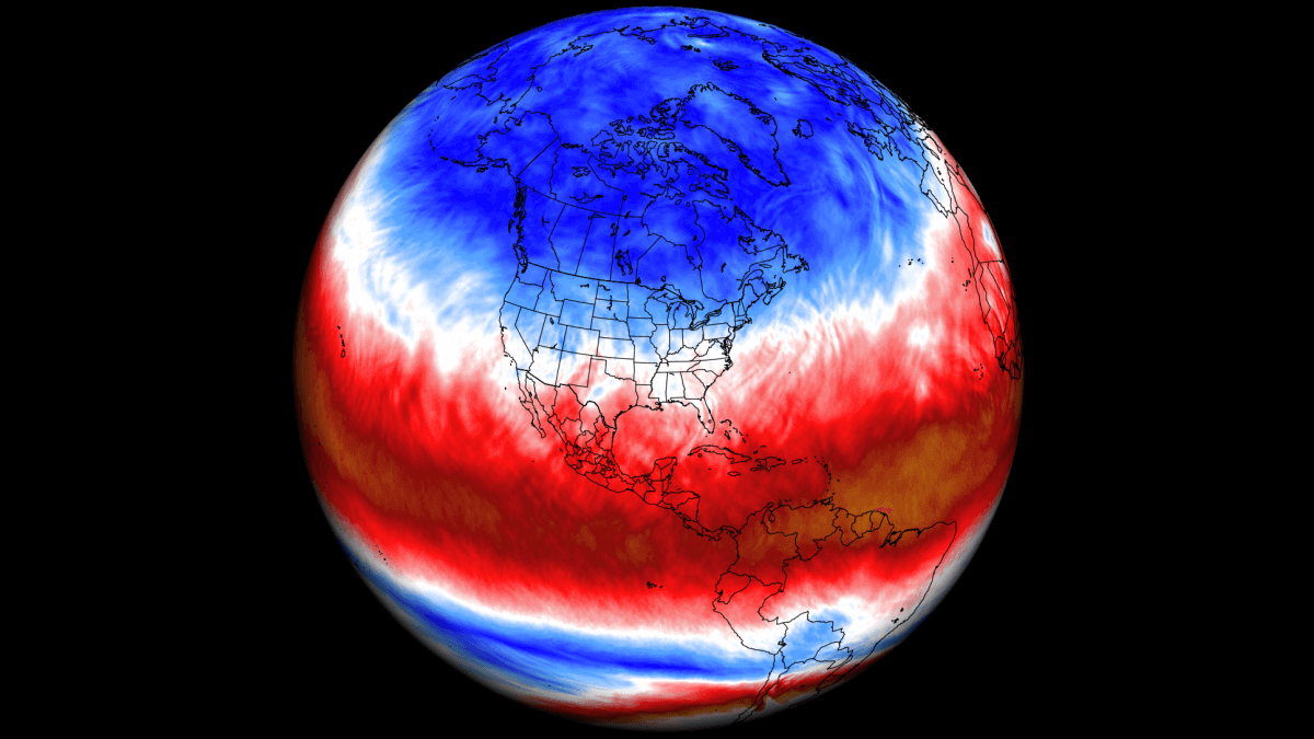
To understand what the Polar Vortex is and what it does, it’s usually best to visualize it. In simple terms, it is just a name that describes the broad winter circulation over the northern (and southern) hemispheres.
For this reason, we separate the entire Polar Vortex into an upper (stratospheric) and a lower (tropospheric) part. They both play their role differently, so we monitor them separately. But it is also very important how they are connected, as it can vary from season to season, often also due to the QBO in the stratosphere. Image by NOAA-Climate.
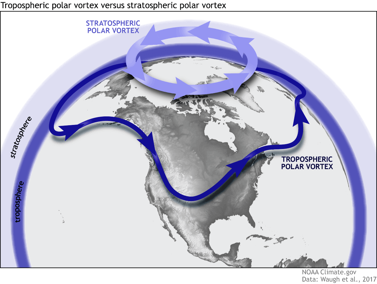
The stratospheric part of the Polar Vortex acts like a large cyclonic area, so it’s strongest when it has a cold core and a strong low-pressure center. So its strength is very important in winter, as it usually has a very strong influence on the pressure patterns below, directly interacting with the daily weather patterns.
A weak Polar Vortex can create a disrupted jet stream pattern and a strong weather response. As a result, it has a harder time containing the cold air, which can now more freely escape from the polar regions into the United States or other mid-latitude regions.
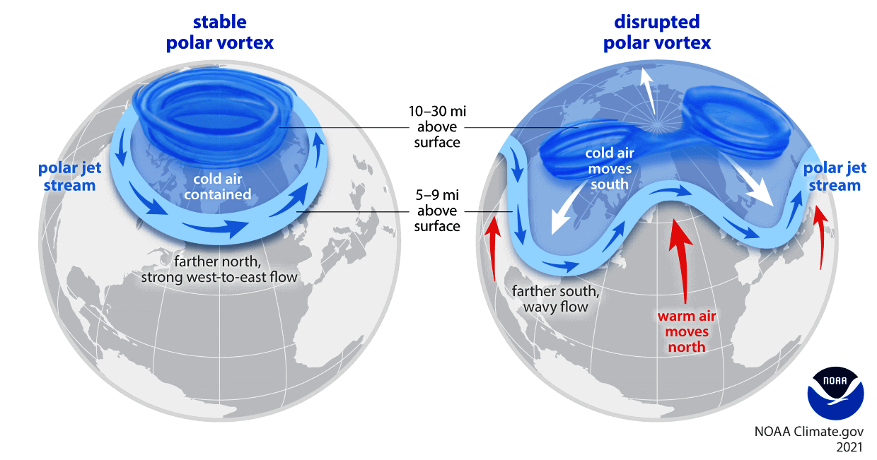
So, if you want a colder and snowier Winter, your best bet is a weak Polar Vortex. In nature, a weak Polar Vortex essentially means a breakdown of the circulation. And as you will see, a negative QBO does favor a weaker Polar Vortex in the stratosphere.
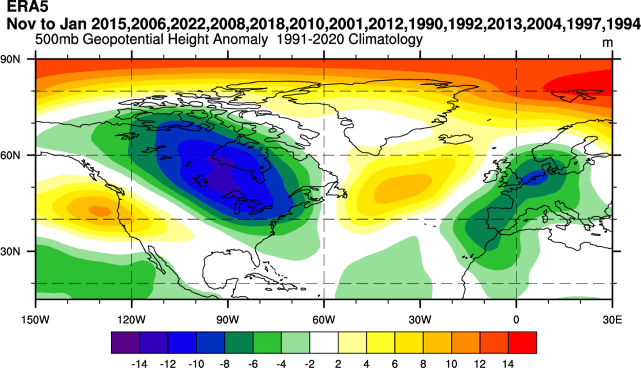
The image below shows a stratospheric pressure analysis of several past winter years with a negative QBO. It shows a high-pressure anomaly, which means that the Polar Vortex is usually weaker and also displaced from the usual polar area.
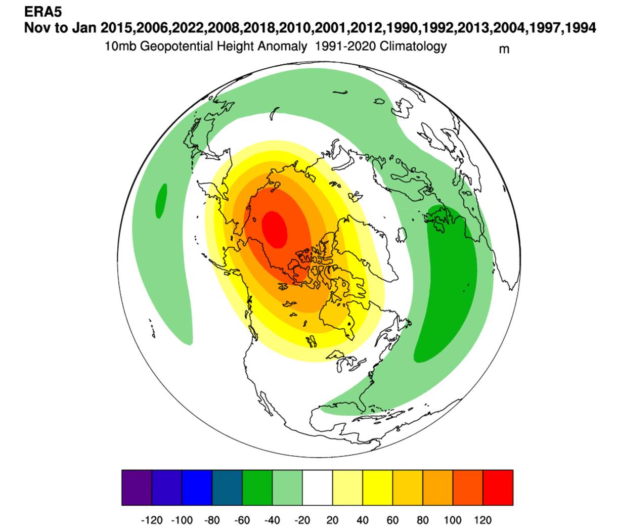
We have to note at this point that several different years are in the mix of this image. There are several large, global factors that shape winter weather patterns, like ENSO in the Pacific, for example. So this is not a direct analysis of negative QBO-only effects, but just a general idea of what to expect in such seasons.
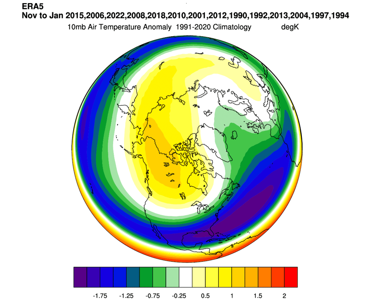
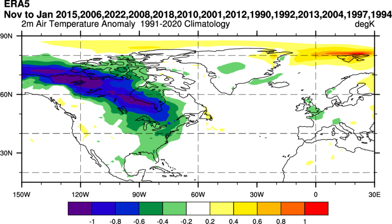
Also, looking at the stratospheric temperature anomaly for the same winters, you can see a warm anomaly in the polar stratosphere. This also shows a warmer core of the Polar Vortex, usually weakening the whole circulation.
During an easterly QBO, the atmospheric wind profile is also more favorable for the upward propagation of planetary (Rossby) waves from the troposphere into the stratosphere. That disrupts and weakens the Polar Vortex, making it more prone to collapse and disrupting the weather patterns below.
Being over the Equator, the QBO is directly connected to the higher levels of the atmosphere and the overall atmospheric circulation that affects the state of the Polar Vortex.
But we will now go from the high levels down to the lower levels, and look at the latest Winter 2025/2026 forecast data to find some early hints for colder development.
WINTER 2025/2026 EARLY COLD SIGNS
Before we look at the latest winter forecast images, we have to look at the analysis data for some past winters with a negative QBO. Below you can see the pressure anomaly for some negative QBO winters in the past. Right away, you can see a low-pressure anomaly over Canada and the eastern United States, and also Europe.
You can see a high-pressure blocking over the polar regions, which is an indication of a weaker polar circulation (Polar Vortex) and a more disrupted jet stream pattern. Again, we can’t say it’s only because of the QBO, as there are many other factors at play, but the common factor in these winters is a negative QBO.
Looking at the resulting temperature anomalies, you can see a clear area of colder temperatures in Canada, expanding into the Midwest and the eastern United States. This is a result of the broad low-pressure anomaly creating a strong (cold) northerly flow as it spins counterclockwise. Europe also shows a weak colder signal.
This can give us a broad idea of the large-scale forces at play and how they can impact the weather patterns globally. But instead of just looking at past winters, we can also find some impact signals in the forecast data.
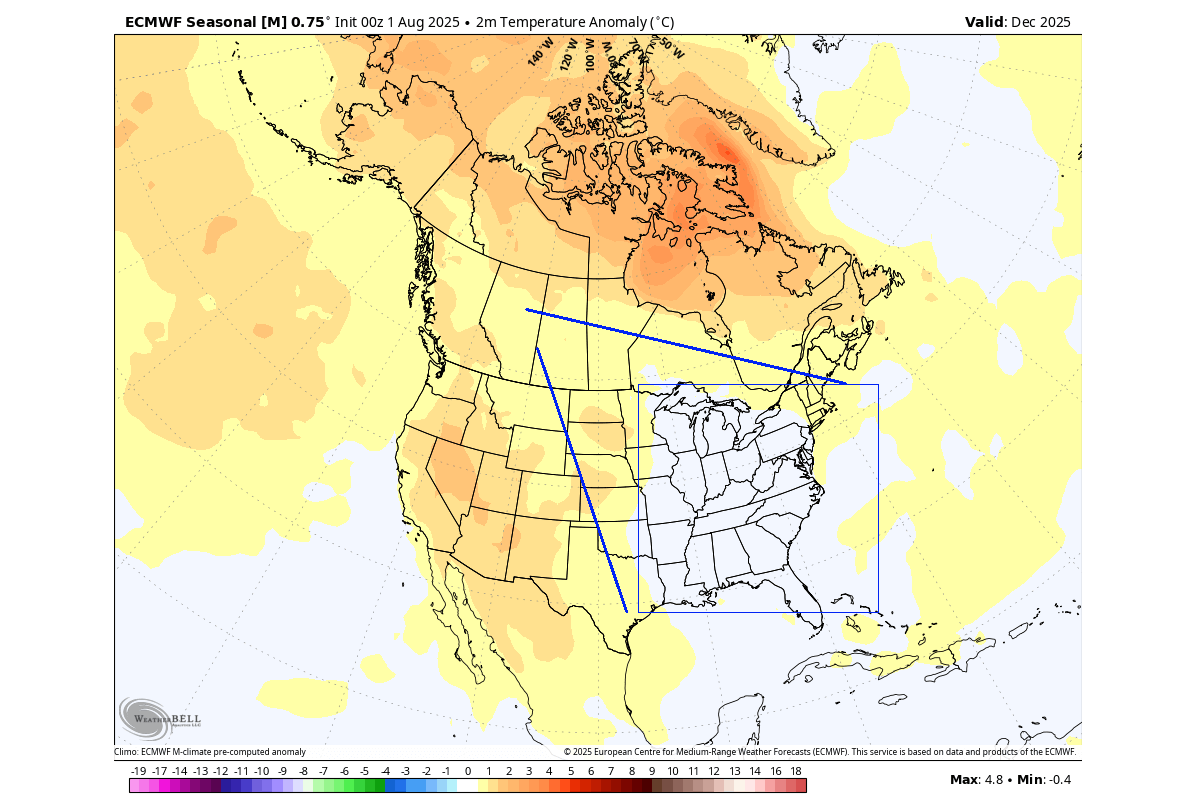
The latest ECMWF seasonal forecast data was just released, and it is starting to show some really exciting results. First, we have the December 2025 pressure forecast for North America. You can see the high-pressure anomalies over the polar regions, a sign of a weaker Polar Vortex.
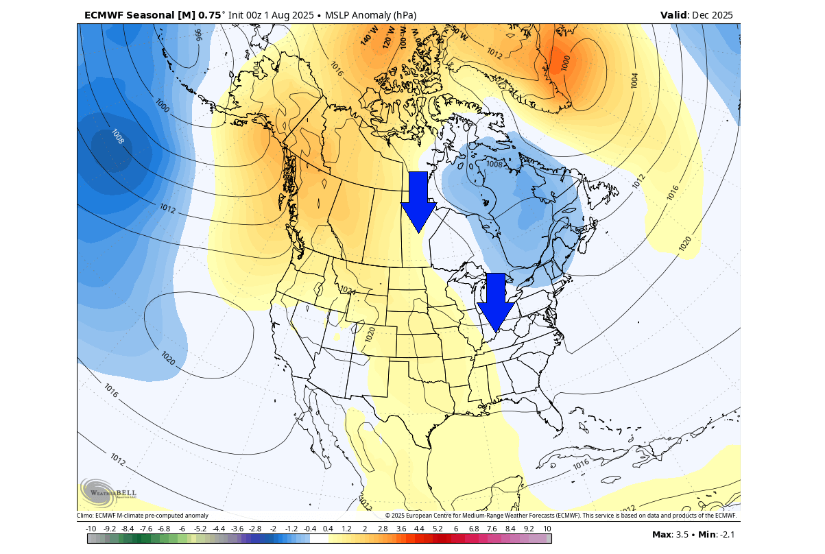
A low-pressure anomaly is forecast over eastern Canada, creating a northerly flow as it spins counterclockwise. If the airmass over Canada is cold enough, this can bring some colder days and snowfall into the central and eastern United States this December.
The temperature forecast does not show a clear, broad cold anomaly, but we can see the typical pattern of a cold corridor. You can also see that the eastern United States shows no warm anomaly, which is an indication in itself. This indicates a northerly flow, resulting from the low-pressure area over eastern Canada.
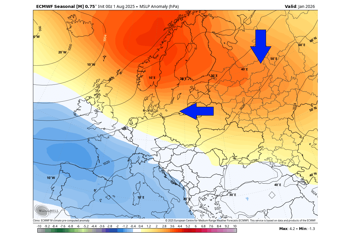
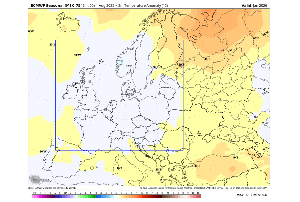
Looking at Europe, the most interesting month in the winter forecast is January 2026. Below is the pressure anomaly forecast, which shows a broad high-pressure blocking pattern over the north. As an anticyclone spins clockwise, this means a colder northerly to northeasterly flow across the continent.
We can see this on the temperature forecast below, which shows normal to colder temperatures over a large part of northern, central, and western Europe. The forecasts usually underestimate cold anomalies this far out, so it’s safe to assume such a pressure pattern would bring broad colder weather over the marked area.
Both the high-pressure blocking over northern Europe and over the polar regions are clear signs of a weak or disrupted circulation and a weaker Polar Vortex.
A weaker Polar Vortex is usually much more prone to a full-scale collapse due to increased pressure and temperature in the stratosphere, as shown earlier above. This can be a main event of the Winter season, bringing or extending cold days and snowfall across several weeks.
SUDDEN STRATOSPHERIC WARMING EVENT
A proper Polar Vortex collapse event is called a Sudden Stratospheric Warming (SSW). Basically, it means a strong temperature and pressure rise in the Stratosphere and a resulting collapse of the Polar Vortex circulation. And as we have shown above, the easterly QBO can play a big role in that.
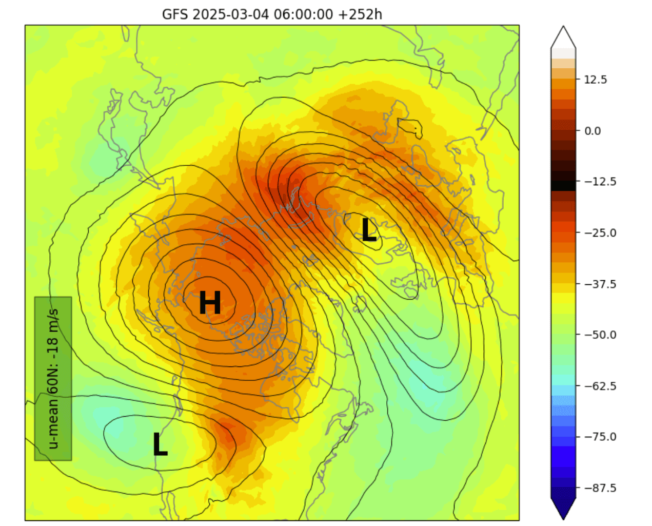
One such major event was recorded this March. Below you can see the temperature in the mid-stratosphere as the Sudden Stratospheric Warming event was in progress. It shows the stratospheric high-pressure system (H) taking over the polar regions and splitting the Polar Vortex into two separate cores (L), breaking it down fully.
We produced a video below that shows the stratospheric Polar Vortex in 3D, giving a great visual idea of its structure. You can see the Polar Vortex collapsing due to a strong Stratospheric Warming event in March, splitting it into separate cores and collapsing it until next Fall.
But what does such an event mean for our everyday weather at the surface? Well, you have to understand that it can take some time for the effects from the Stratosphere to reach the lower levels. That is why we usually look at the weekly periods after such an event to identify the resulting weather changes.
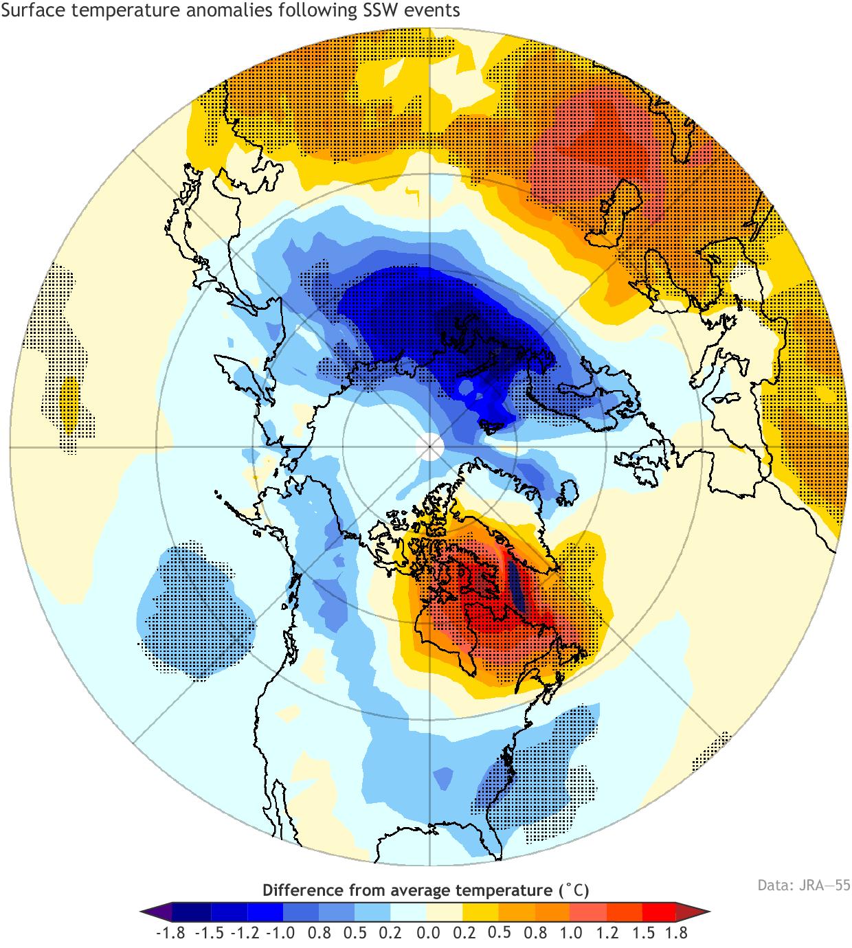
Below is the average temperature of 0-30 days after a Polar Vortex collapse event. This shows that most of the United States and northern and central parts of Europe are typically colder than normal after an SSW event. But note: Each stratospheric warming event is different and does not automatically mean a strong winter pattern.
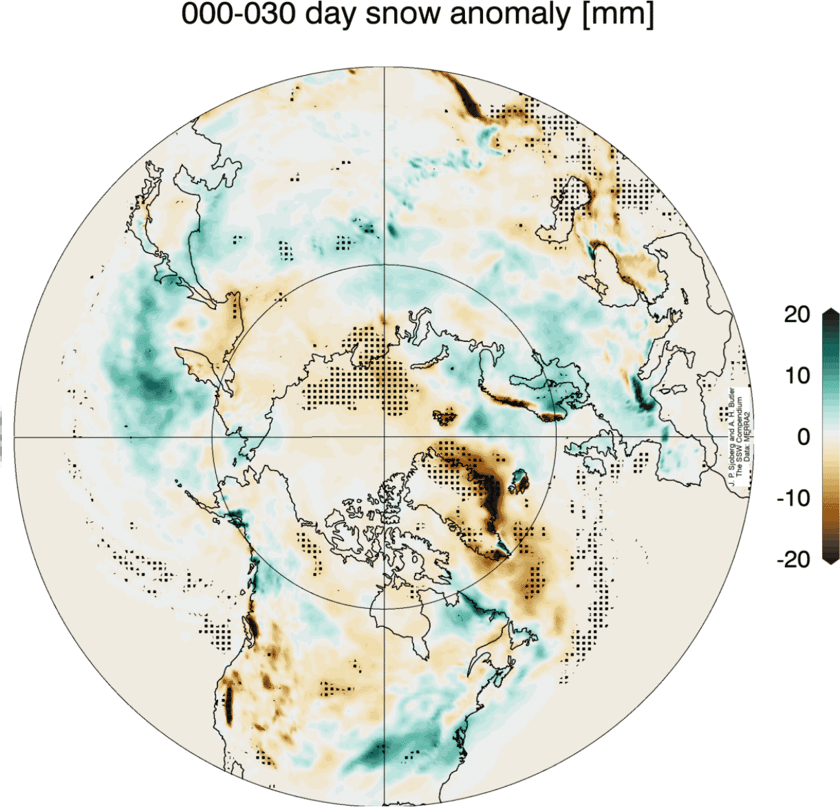
Looking at the snowfall after SSW events, we can see above-average snowfall over much of the eastern United States. the Midwest, and Europe. This is because of the pressure changes after a stratospheric warming that enable the colder air an easier path towards the south and into these regions.
As you can see, a weak Polar Vortex can significantly change Winter weather in the United States, Canada, and Europe. In a negative QBO season, the chances of a Polar Vortex collapse are increased, which is why we always closely monitor the developing wind anomalies before a winter season begins.
With strong signs emerging for a weak Polar Vortex in 2025/2026, the likelihood increases for colder winter days and more snowfall over the United States, Canada, and parts of Europe.
Learn more: Strong early signs suggest a different Polar Vortex will develop for Winter 2025/2026
Forecast images in this article were provided by WeatherBell, using a commercial license.
We will keep you updated on the global weather pattern development, so bookmark our page. Also, if you have seen this article in the Google App (Discover) feed, click the like (♥) or the star button there to see more of our forecasts and our latest articles on weather and nature in general.