The meteorological Winter season has officially ended, but the atmosphere is currently locked in a dynamic seasonal transition. As we move deeper into Spring 2026, the global weather pattern is being shaped by a persistent, “leftover” Polar Vortex core over North America, and the rapid emergence of a potential Super El Niño in the tropical Pacific.
Latest satellite and model data confirm that, while the La Niña has dissipated, its atmospheric footprint persists, allowing the low-pressure core to remain stabilized over North America. As indicated by past data analysis, this is to be expected in years with rapid La Niña-to-El Niño transitions.
In this update, we will analyze the forecast for the remainder of March and the official April-May-June seasonal data. We will also look at how the Polar Vortex core will influence temperatures across the United States, Canada, and Europe, and how a Super El Niño is likely to surface in the months ahead.
Winter-Spring 2026 Dynamic transition over the Northern Hemisphere
The meteorological Winter season covers the December-January-February period, so we are now already in the meteorological Spring. But in weather, the true seasonal transition does not happen overnight, but is a gradual process.
The whole of March can be considered as a Winter-Spring transition period. And since half of the month is already behind us, we will look at the remaining two weeks and what it brings, before the Spring season begins in full scale.
Below is the ECMWF pressure pattern forecast trend, and it shows the pressure anomaly for the remainder of March. The main feature for the rest of March will be the strong Polar Vortex core over eastern Canada, which will also impact the northern and eastern United States.
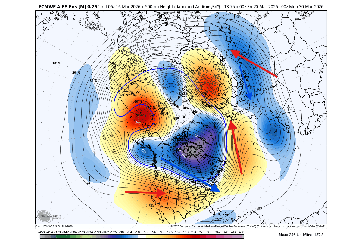
We can also see this Polar Vortex core helping to build a high-pressure area over northwestern and northern Europe, and a low-pressure zone over the south as a result.
This position of the low-pressure Polar Vortex core allows the colder-than-normal air to drop into the eastern and northeastern United States. Below is the 1-5 day temperature forecast, which shows a period of colder descending into the eastern half of the United States, extending down from northern and eastern Canada.
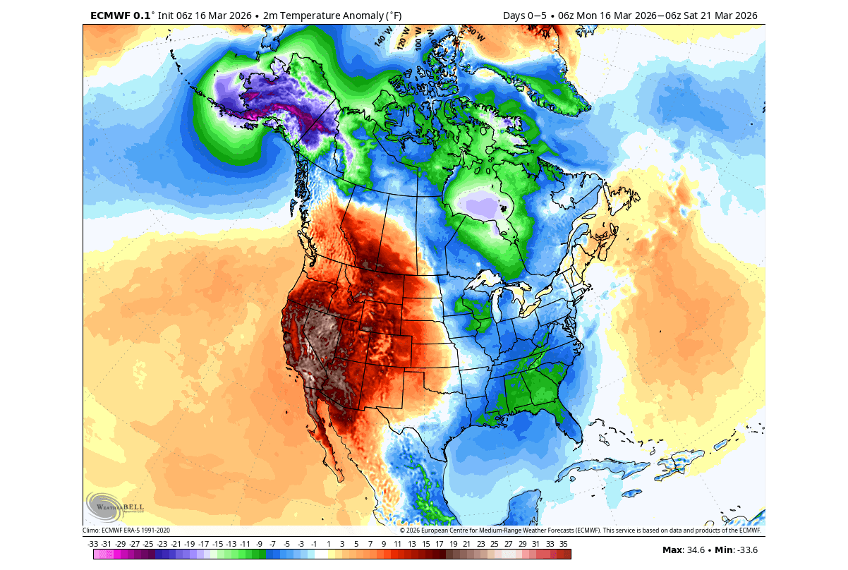
This is a typical effect of a Polar Vortex core, which can bring below-normal or cold temperatures well into early spring across the United States.
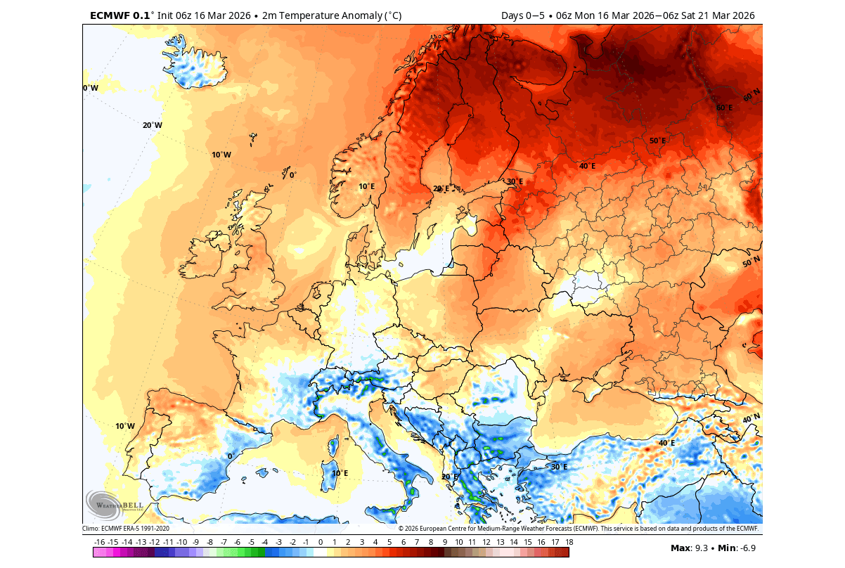
Looking at Europe in the 1-5 day range, we can see a warmer anomaly over the northwestern and northern parts, resulting from the high-pressure zone, aided by the Polar Vortex core over Canada. A colder front will spread across the central and southern parts.
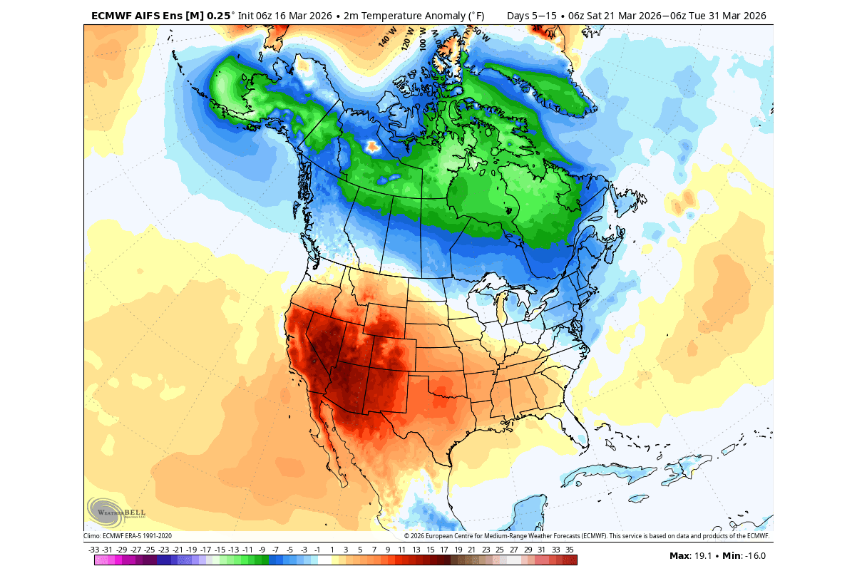
But looking into the last 10 days of March, we can see the warmer air expanding from the western into the central and southeastern United States, as the Polar Vortex core eases back to the north. You can still see an impressive area of cold anomalies under the Polar Vortex core in Canada, still having a slight impact on the upper Midwest and the northeastern U.S., keeping the temperatures below normal.
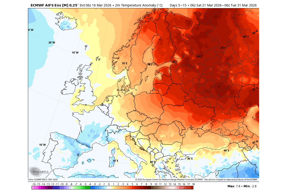
Across Europe, the last 10 days of March bring warmer anomalies towards the north and east. Normal to cooler conditions are expected over the southwest, under a low-pressure pattern over the south parts, while high-pressure systems dominate the north and northeast.
But as we go deeper into the proper Spring season, the global weather system will also change due to a strong ocean anomaly in the Pacific.
The ENSO Anomaly: How the Ocean can Drive the Atmosphere
ENSO is the ocean-atmosphere system in the tropical Pacific, short for El Niño Southern Oscillation. This ocean area alternates between cold and warm phases, with each phase producing different global weather patterns.
In the image below, you can see a direct comparison between ocean temperature anomalies for each of the two ENSO phases. Both examples show realistic data from the 10 strongest events for each phase, the warm El Niño and the cold La Niña.
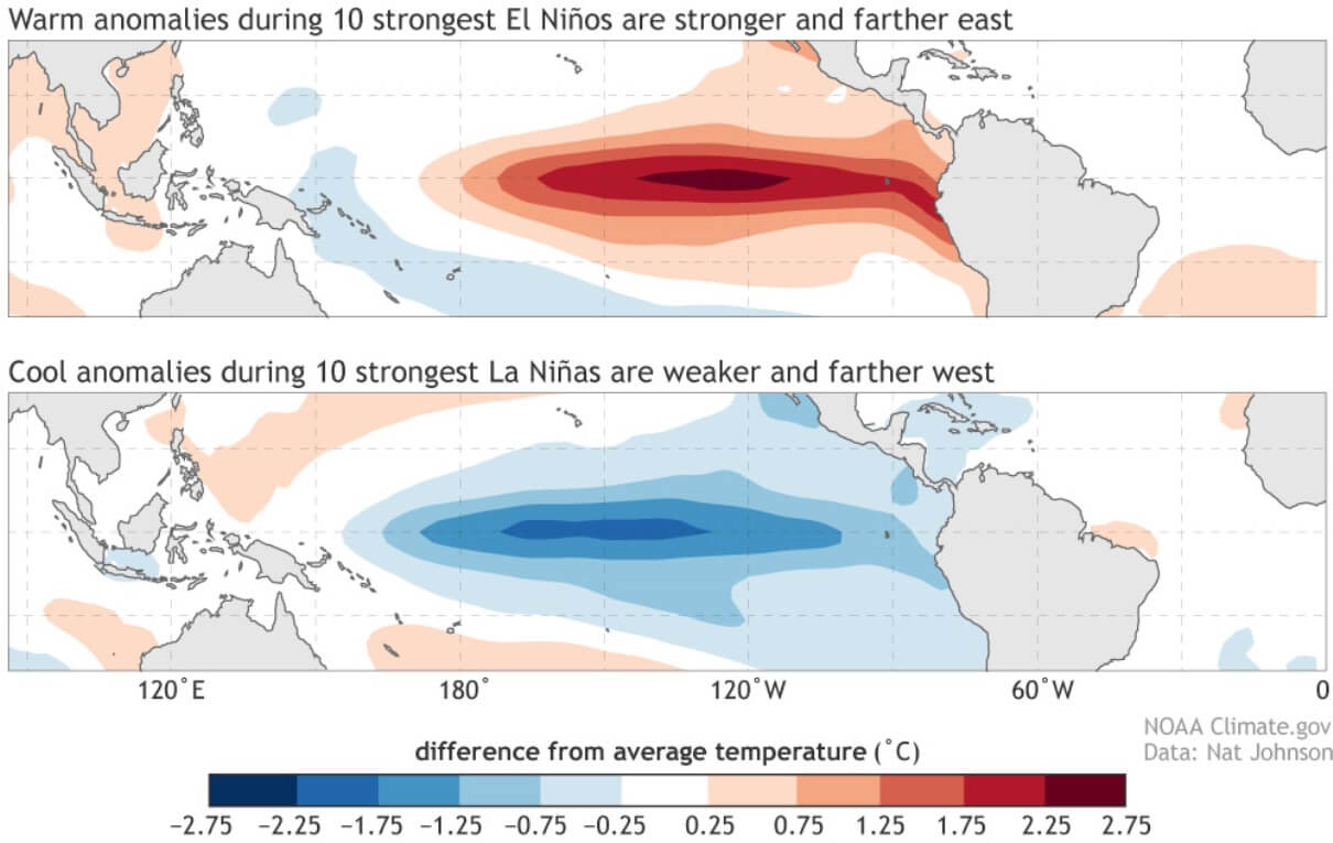
Each phase has a very different impact on the pressure and rainfall patterns in the tropics. Over time, these changes also start to impact the global weather circulation. As mentioned, the La Niña event was a major driver during the current Winter. It was a weaker event, but it still influenced weather development across the United States and Canada.
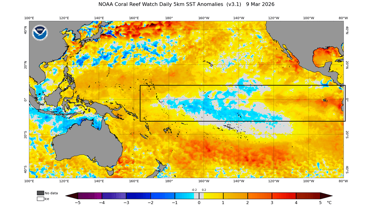
The latest ocean analysis below shows the main ENSO region with some leftover cool patches, but the overall average anomaly for the region is already in positive values. That is mainly due to the large expansion of warm anomalies in the eastern region, which is already seen below with temperatures 2 degrees above the normal values. Image from NOAA CRW
The whole change process is nicely shown in the image below, revealing the latest 30-day ocean temperature change map. You can see a strong warming trend across the whole ENSO region. A stronger burst of warming is seen in the eastern parts, driven by the weakening trade winds and an ongoing warm Kelvin Wave below the ocean surface.
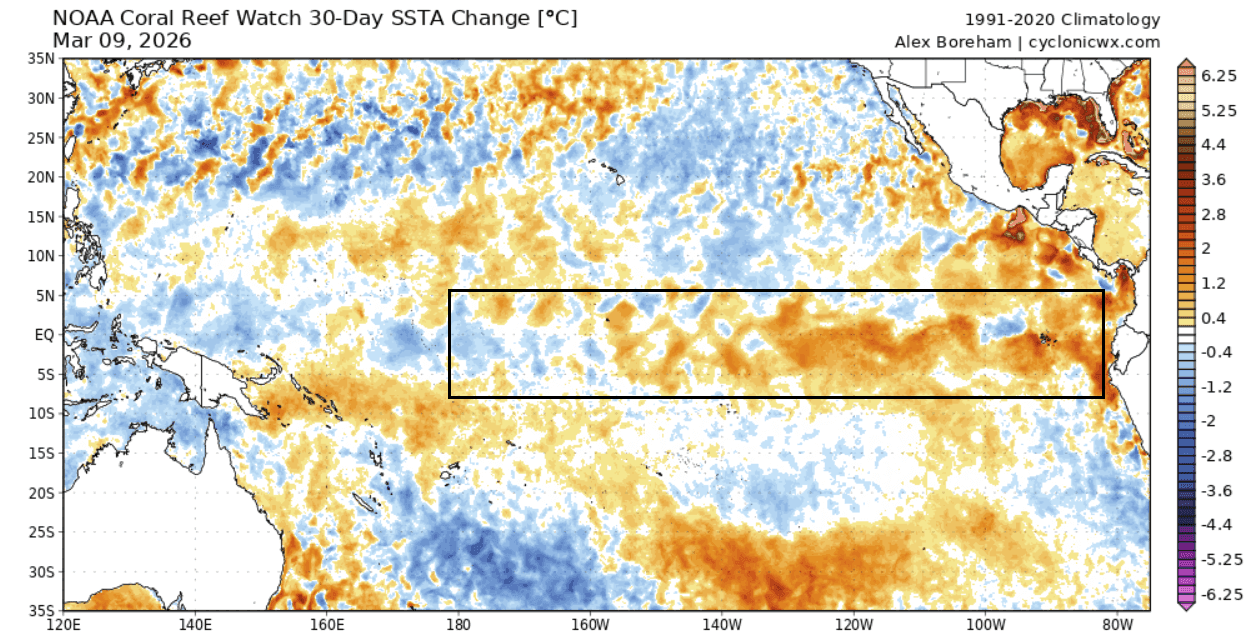
These subsurface Kelvin waves are driven by the westerly wind bursts in the tropical Pacific. They move at depth and then resurface in the eastern ENSO regions, helping the expansion of warm anomalies and kickstarting an El Niño event.
This is much better seen in the video below, which shows the last few months of subsurface ocean temperature changes in the ENSO region. You can see a healthy La Niña event below the surface and how the warm Kelvin has made its way across the ocean in recent months, fully eroding the cold pool of the La Niña.
The long-range forecasts already see this development, and are hinting even at a “super” event to emerge later in 2026.
Global Weather Shift: The Rise of a Super El Niño in 2026
Looking ahead, we can see a clear indication of a rapid rise of the new El Niño event. All the latest forecast data shows the next warm ocean event to arrive by Summer, but we are still waiting for the final consensus on its actual strength.
Below you can see the new ENSO multi-model forecast for the next few months from the C3S system. On the left is the forecast for the main ENSO region, and on the right is the forecast for the eastern (ENSO 3) region. This is a combined forecast from multiple long-range systems and shows a rapid shift into an El Niño.
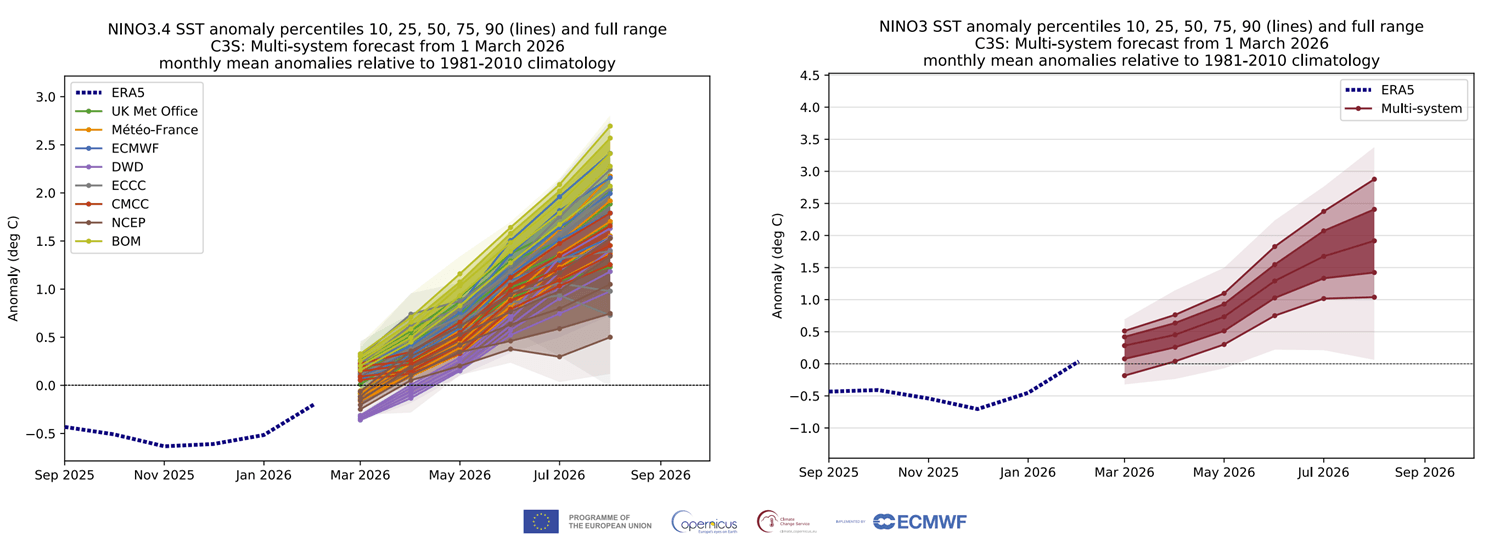
The average value of these forecasts shows a high chance for a Super El Niño to develop, which requires the seasonal average to be sustained at or above +2 degrees.
A Super El Niño is different from a normal event because the warming in the Pacific becomes stronger, resulting in an amplified impact on global weather. This usually leads to much more extreme weather shifts, turning typical seasonal changes into high-impact events like massive flooding, severe droughts, and significantly altered storm tracks that can affect the entire planet.
Looking also at the latest NMME multi-model forecast for late Summer and Fall, you can already see a clear El Niño warm anomaly in the Pacific. The peak warm anomalies in this forecast reach or exceed the threshold for a Super El Niño event in 2026/2027.
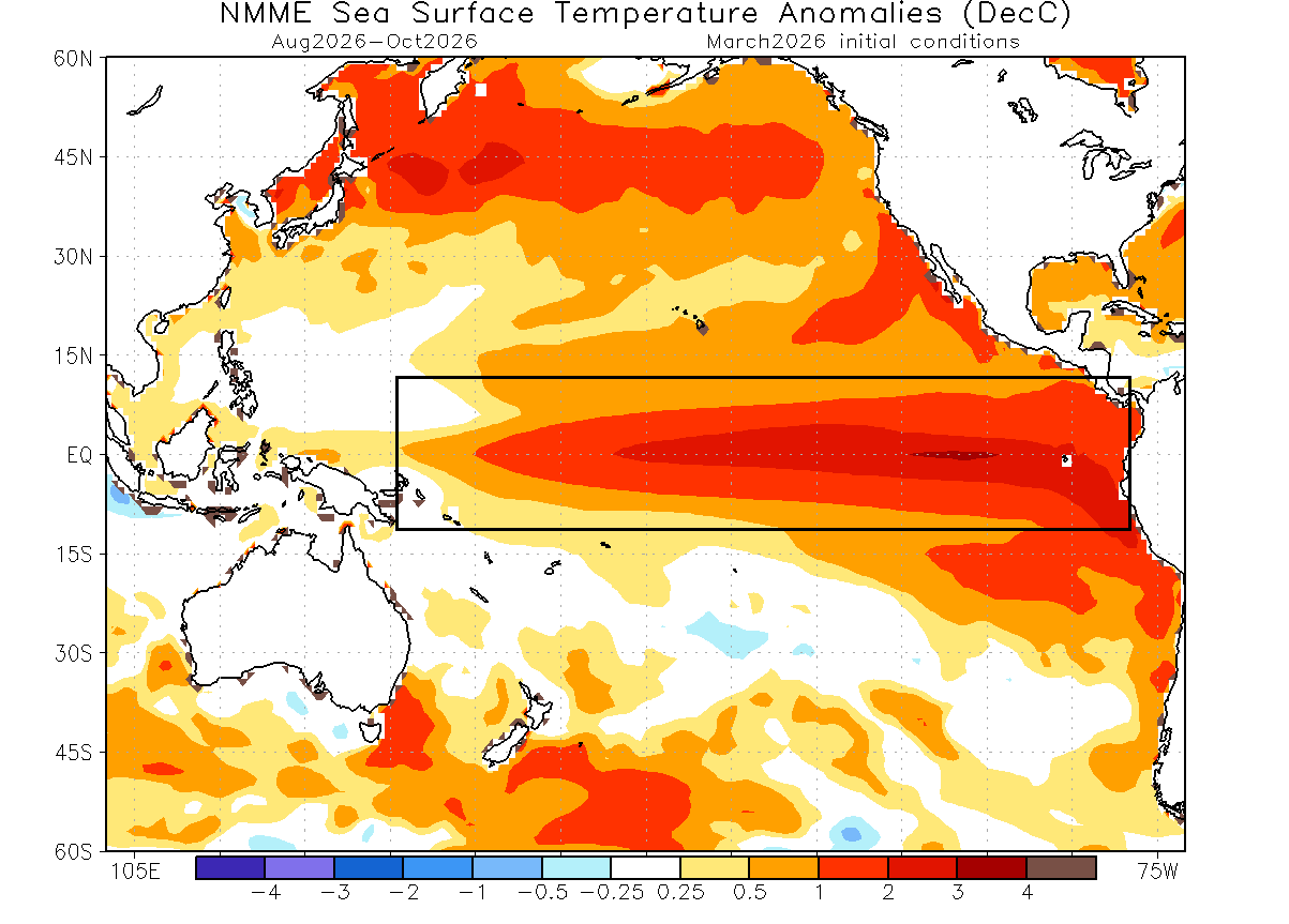
All major forecasts show a clear, rapid transition from a cold to a warm ENSO phase. This tells us that we are heading for a strong global weather shift in 2026. And on top of this, it appears that the new event is likely to be in the “Super El Niño” territory
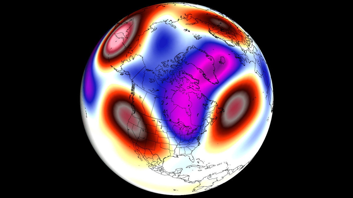
For this reason, we decided to look at reanalysis data to find past years with a similar shift from a weak cold ENSO phase into an El Niño. We found several such years in the past, and we merged them together to get the temperature pattern in such rapid transition years.
Below is the Spring temperature anomaly in these rapid transition years, made from ERA-5 data. You can see a cold air anomaly over western and eastern Canada. This is part of a cooler area that is also reaching into the northern, southwestern, and northeastern United States. This is a 3-month average, and shows a cooler Spring tendency for the northern and eastern United States in such transition years.
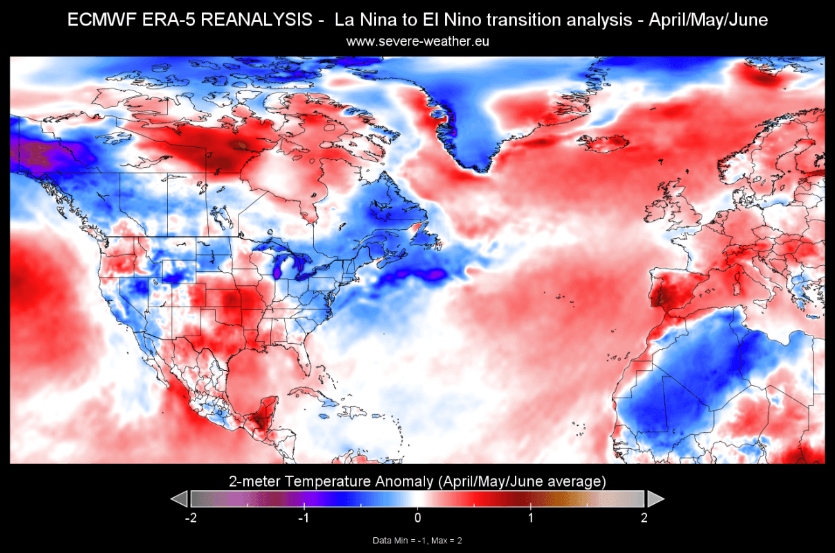
Over Europe, we can see that a warm anomaly is present over most of the continent, driven by a low-pressure area over the Azores, which is helping to “pump” warm air into the continent.
Here, I have to add that some of these years are from the past decades, which naturally exhibit a colder signal. But the overall pattern is clear, and the trend for lower than normal temperatures over southern Canada and the northern and eastern United States, and warmer temperatures over Europe.
We will now look into the new long-range forecast data to see if this signal appears over for Spring 2026 over the United States, Canada, and Europe.
Spring 2026 Forecast: Lingering Polar Vortex Core Impacts the Pattern
Since March is already half done, and to properly capture the seasonal pattern, we decided to use the April-May-June seasonal period for the Spring Forecast.
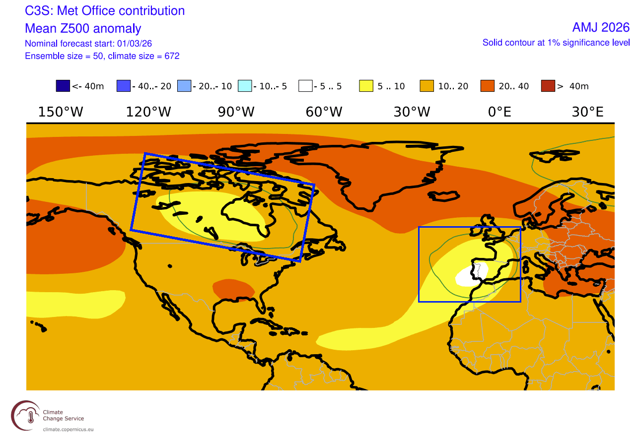
The latest pressure pattern forecast from ECMWF indicates a low-pressure zone over Canada and the northern United States. This is the leftover core area of the Polar Vortex that we talked about above, stabilized over North America by the high-pressure area in the North Pacific.
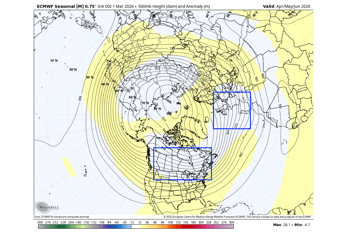
Another potential low-pressure area is over the eastern North Atlantic or western Europe, impacting the precipitation and temperature patterns over the continent.
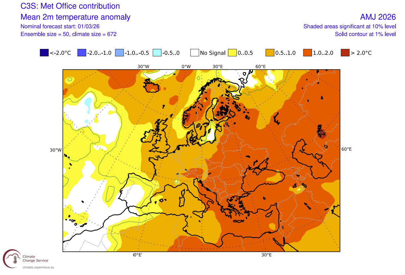
Below is the Spring temperature forecast for North America, where the forecast hints at normal surface temperatures over the northern and eastern parts of the United States, with even below-normal temperatures over southern Canada. Most of the western United States is forecast with much above normal temperatures, but the anomaly is decreasing towards the east.
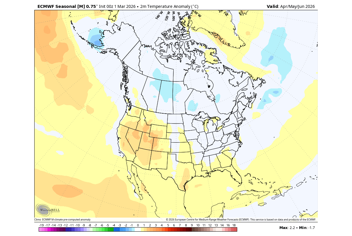
This is a direct result of the leftover Polar Vortex core over Canada. It can create below normal temperatures in Spring over the area, and also keep the temperatures in check over the northern and eastern parts of the United States.
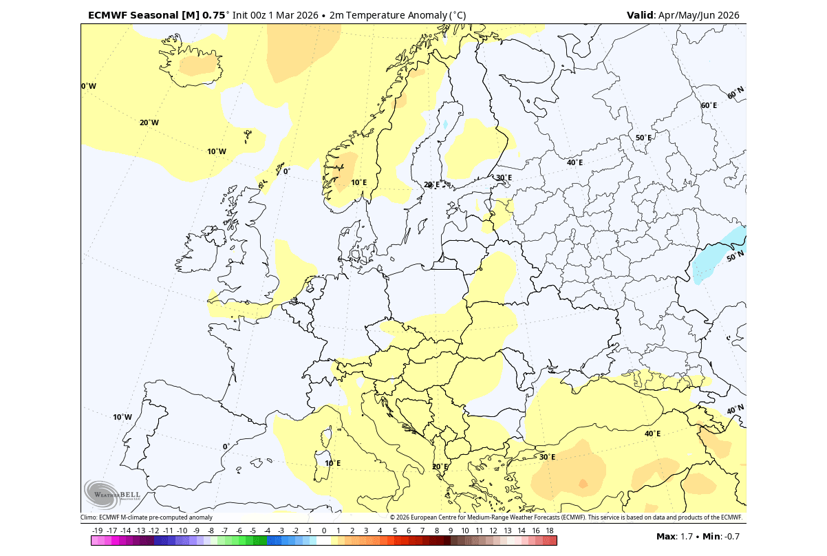
Over Europe, we can see a warmer trend for the central and southern parts, and up towards the north. But we can also see a normal area over western and northwestern Europe, indicating the near presence of a low-pressure zone.
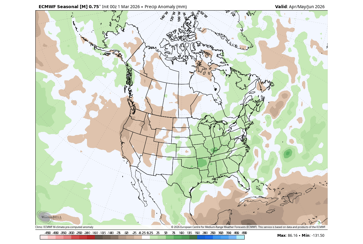
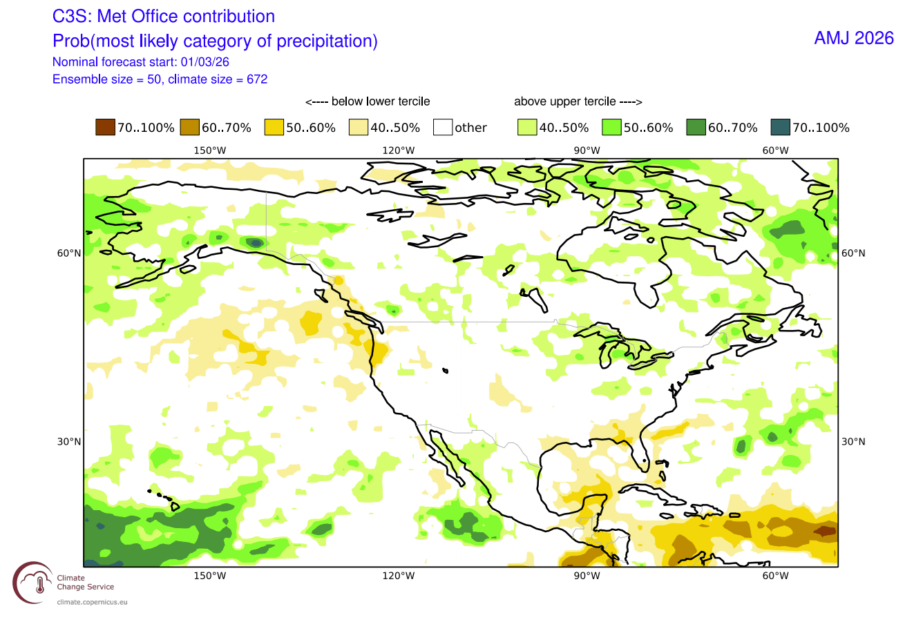
The North American precipitation anomaly forecast below shows a dissipating La Niña-type pattern over Canada and the United States. Wetter conditions are forecast over the eastern and south-central United States and eastern Canada. Less precipitation is forecast for the western United States and western Canada.
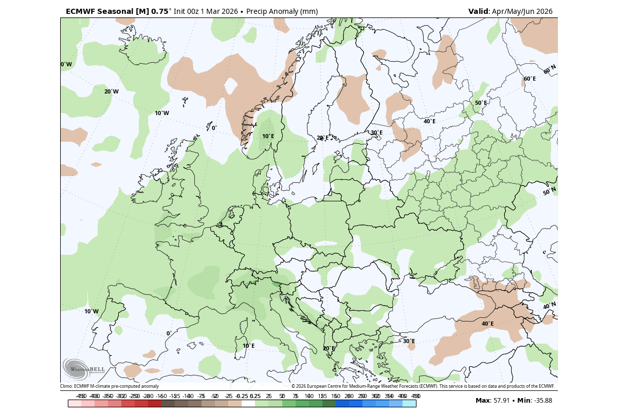
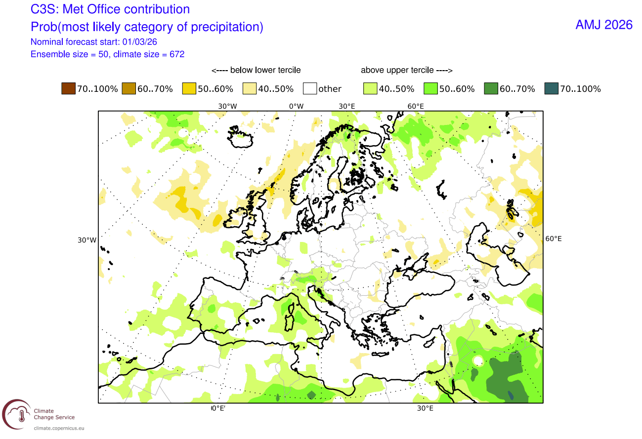
The ECMWF precipitation forecast over Europe shows an interesting wetter signal over a large part of the continent. This is very likely related to the forecast presence of a low-pressure zone somewhere across far western Europe and the eastern North Atlantic, keeping a steady flow of moist Atlantic air.
But this is a seasonal forecast from just one long-range model, so we usually add another model to the mix to see how consistent a given idea or trend is.
The UKMO Outlook: Comparing Global Models for the Spring Season
As mentioned, we often use the UKMO long-range model from the United Kingdom Met Office. This way, we can compare results, and if both models show a similar forecast, that means a higher confidence in the accuracy of the weather pattern overall.
The UKMO model agrees with the ECMWF over the North Pacific high-pressure systemm the Canada Polar Vortex low, and a low-pressure area over western Europe. This is very interesting, as it is a very similar idea to the ECMWF, giving a good confidence in the likelihood of this scenario.
The temperature forecast below shows the indication for a more northwesterly flow over Canada and into the northeastern United States. This is very similar to the idea of the ECWMF. Above normal temperatures are forecast over the western and southeastern United States by this model.
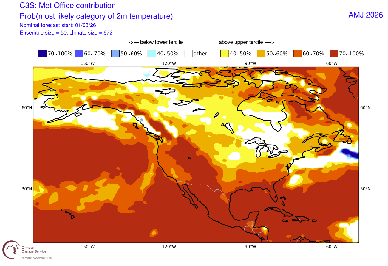
This graphic shows the most likely temperature category, which better highlights and unveils the probable northwesterly flow into the northern and northeastern United States, and also the Midwest.
Over Europe, we can see normal temperatures over the southwest under the low-pressure zone, and a warmer flow towards the east and northeast. This is similar to the idea of the ECMWF, with a low-pressure zone to the west.
The precipitation forecast shows a trend for less rainfall over the southern and south-central United States and the Pacific Northwest. More precipitation is forecast by this model over Canada, the Midwest, and the northern and northeastern United States.
The precipitation forecast for Europe shows more rainfall over the western, southern, and central parts, and also over the far north. Less rainfall is forecast in the northwest, over the United Kingdom and Ireland. This shows the expected western low-pressure zone pattern, where moisture is being transferred from the Atlantic and the Mediterranean into the mainland to increase precipitation.
But there is one more outlook that we always check, and that is the official NOAA seasonal outlook for the United States, which also includes a professional human factor in the forecast.
NOAA Official Spring Outlook for the United States
Below is the official Spring temperature forecast for the United States by NOAA. It shows the temperature probability, with colder to equal chances in the northern United States. The southern half of the country and the northeast have a higher probability of warmer than normal weather, as seen in the models above.
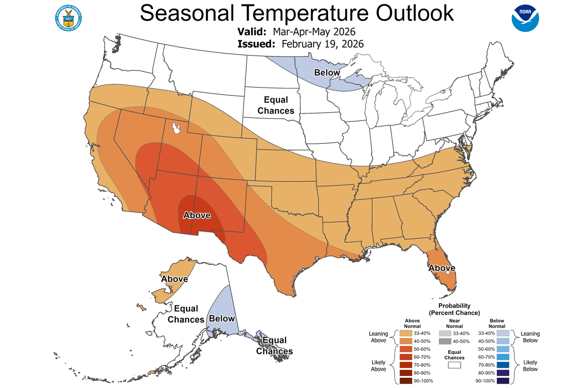
We can see this is very similar to the model forecasts above and the proximity of a low-pressure area over Canada. This is the leftover core of the Polar Vortex, keeping the temperatures in check over the northern half of the United States.
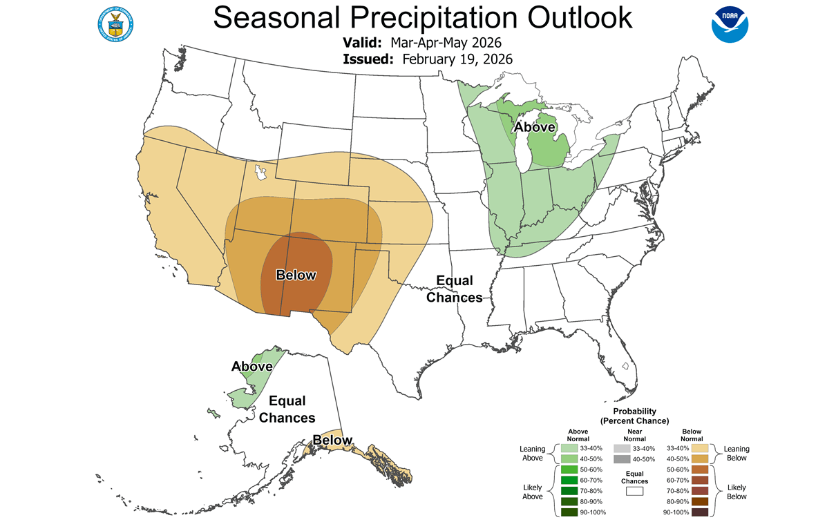
The official precipitation forecast is also quite similar to the model forecast and reflects the transitional La Niña pattern. We see an equal-to-higher probability for more precipitation in the Midwest and across the Ohio Valley. On the other hand, the southwestern United States is forecast to have a drier-than-normal spring season.
We will keep you updated on the developing weather trends in the coming seasons, so bookmark our page. Also, if you have seen this article in the Google App (Discover) feed, click the like button (♥) there to see more of our forecasts and our latest articles on weather and nature in general.
The main forecast images in this article are from WeatherBell maps using a commercial forecaster license.
Don’t miss: