LATEST UPDATE: The transition into Spring 2026 is proving to be highly dynamic as a Polar Vortex core lingers over North America while a Super El Niño rapidly takes shape in the Pacific. Below is the link to the latest Spring 2026 Forecast Update and all the information:
Spring 2026 Forecast Update and its impact on the United States, Canada, and Europe.
The Spring 2026 season is approaching, with the latest forecasts confirming a collapsing La Niña still having a diminishing influence over North America. For the United States and Canada, this transition will be dictated by a high-pressure system in the Pacific, while a low-pressure zone over Canada is expected to keep the colder airmass within close reach of the United States.
The meteorological spring spans the March-April-May period, and represents a volatile transition from winter to summer. This year, the pattern will be defined by the rapid collapse of La Niña and the lingering effects of a late-winter stratospheric warming event.
In this article, we will break down the transition from the winter anomalies to the spring outlook, focusing on how the stratospheric warming and the collapsing La Niña are shaping the risks for late-season snow and spring weather patterns across the United States and Canada.
Analyzing the Winter 2025/2026 Verification for North America
The meteorological Winter season covers the December-January-February period. We are now in the final stages of this period, so we can look at the preliminary analysis of the Winter season 2025/2026.
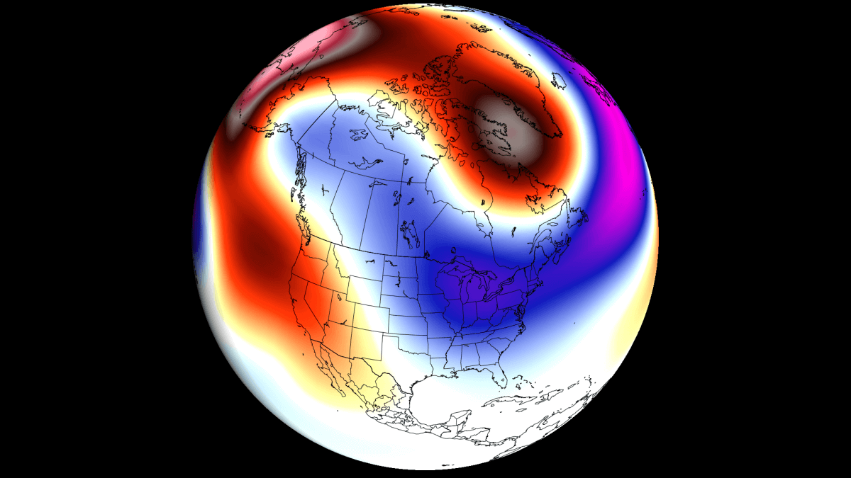
Below is the temperature anomaly for the last 90 days, which covers the Winter season so far. The analysis shows a colder-than-normal winter so far over the eastern and northeastern United States. You can also see warmer-than-normal temperatures over the western and west-central United States and parts of southern and eastern Canada.

But since this is a 90-day average, it hides some of the cold in the central United States, which occurred during individual cold Polar Vortex events.
Below is the December-February long-range temperature forecast, which was issued in early November. It already indicated the potential cold air corridor from western Canada into the northern and eastern United States. It does not show clear temperature anomalies, but we use it to identify trends and potential pattern development.
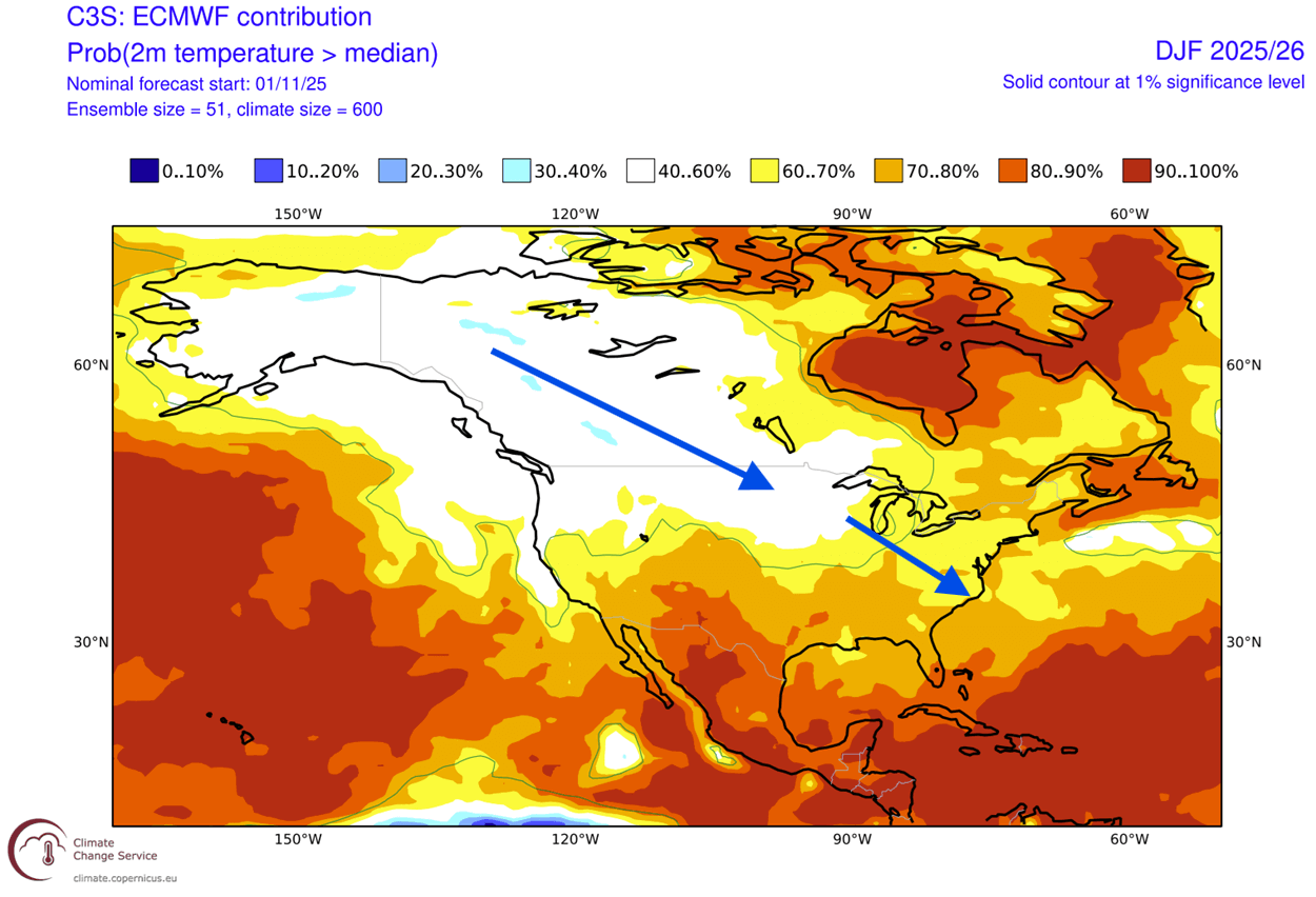
This shows that the forecast had the correct idea of the potential cold air corridor developing across the northern and eastern United States. It also shows that long-range weather modelling can be useful to identify potential weather patterns.
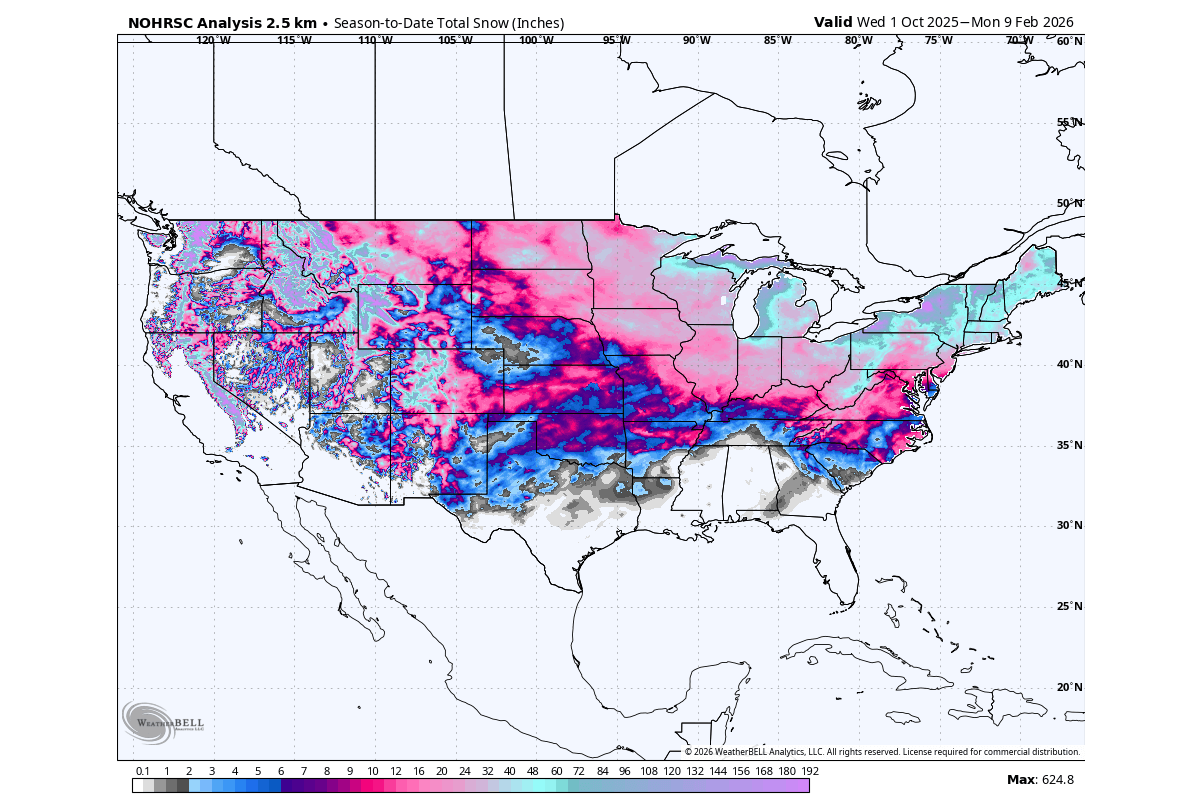
We can also look at total snowfall so far this season, but the NOHRSC data period starts on October 1st. That is because this period is considered the snowfall season or sometimes also the cold weather season. As you can see, this winter so far, a large part of the United States has seen at least some snowfall, including the south and southeast.
Before going into the Spring forecast, we will take a quick look at two major weather processes that will shape the transition from Winter to Spring. One is the shorter-range Stratospheric Warming event, and the long-range impact is from the La Niña collapse in the Pacific Ocean.
How the Recent Stratospheric Warming Impacts the Spring Start
A Stratospheric Warming event is a rapid rise in temperature and pressure in the stratosphere. This causes the disruption of the Polar Vortex, and over time, it causes a disruption in the lower levels of the atmosphere, impacting the weather patterns.
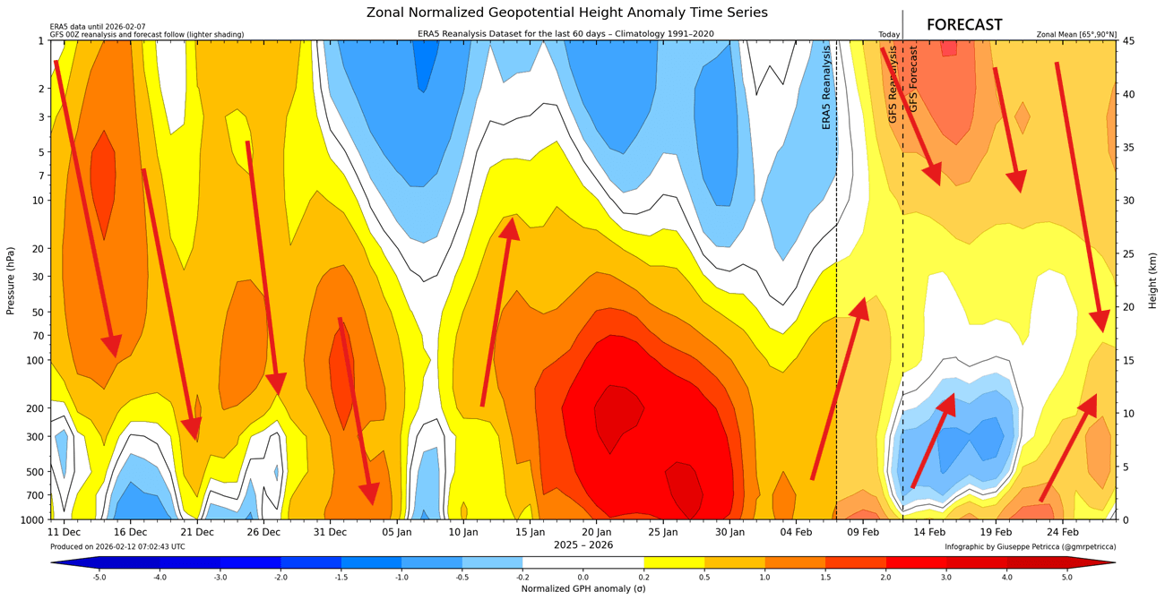
The real extent of the stratospheric warming event is usually revealed by the temperature anomaly, which shows just how much warmer the stratosphere has become. Below is the forecast for the stratosphere at the 10mb level (30km/18.5miles height). It shows a strong stratospheric warming wave, with temperatures peaking over 40 degrees C above normal.
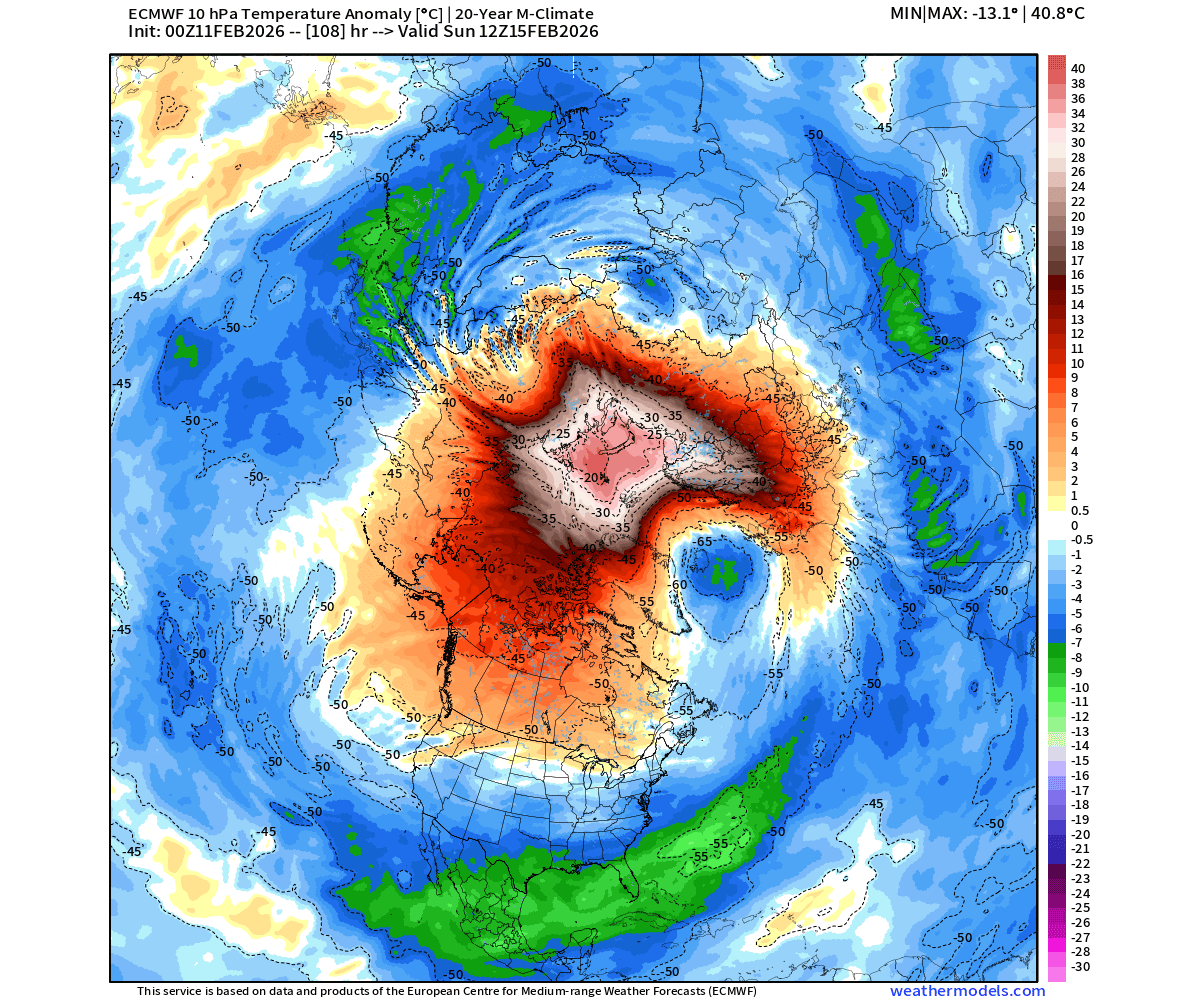
The pressure and temperature anomalies in the stratosphere show a proper stratospheric warming event, which usually creates a downward impact.
The image below shows a vertical structure of the atmospheric pressure anomalies, from the surface up to the top of the stratosphere. You can see the past downward impact of the stratospheric anomalies. But in the GFS forecast part, you can see the stratospheric warming anomaly pushing down, connecting around late month and into early March. Image by @gmrpetricca
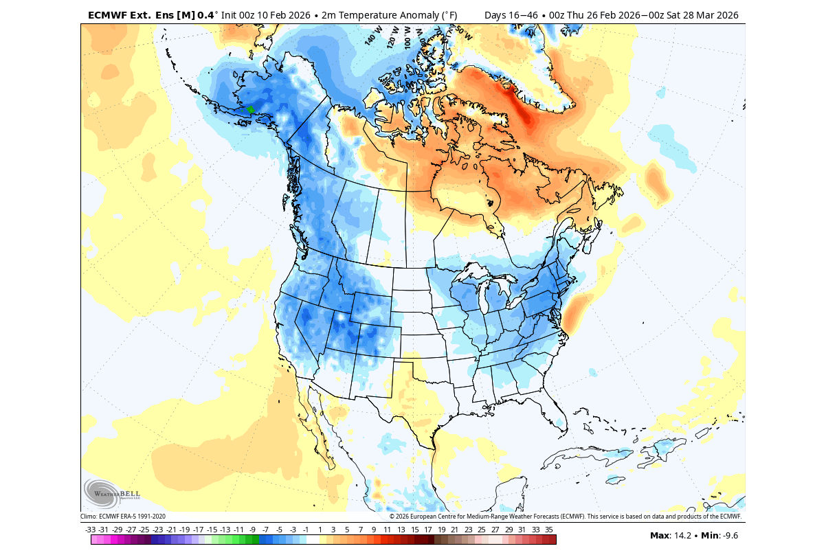
Below is the extended-range ECMWF forecast trend, and it shows the pressure anomaly for the late February-March period. You can see a high-pressure over Greenland and the Aleutians. This enables a low-pressure zone over western Canada, extending into the northern United States.
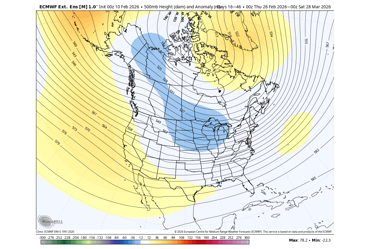
This position of the low-pressure anomaly allows the colder-than-normal air to drop into the eastern and northeastern United States. You can see this in the temperature forecast below for the same period, which also shows cooler conditions in western Canada and the western United States. A temperature rise usually occurs over eastern and northeastern Canada.
But in the long-range picture, March and also Spring weather patterns overall are expected to be under the influence of a large-scale shift in the Pacific Ocean, impacting the whole global weather system.
The La Niña Collapse: A Rapid Shift in Ocean Anomalies
La Niña is just a name for cold ocean temperatures in the tropical Pacific Ocean. The actual ocean-atmosphere system is called ENSO (El Niño Southern Oscillation). This ocean area alternates between cold and warm phases, with each phase producing different global weather patterns.
In the image below, you can see a direct comparison between ocean temperature anomalies for each of the two ENSO phases. Both examples show realistic data from the 10 strongest events for each phase.
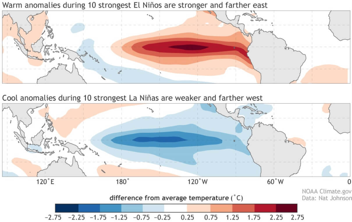
Each phase has a very different pressure and rainfall impact on the tropics, and (over time) on the global weather circulation. As mentioned, the La Niña event was a major driver during the current Winter. It was a weaker event, but it still influenced weather development across the United States and Canada.
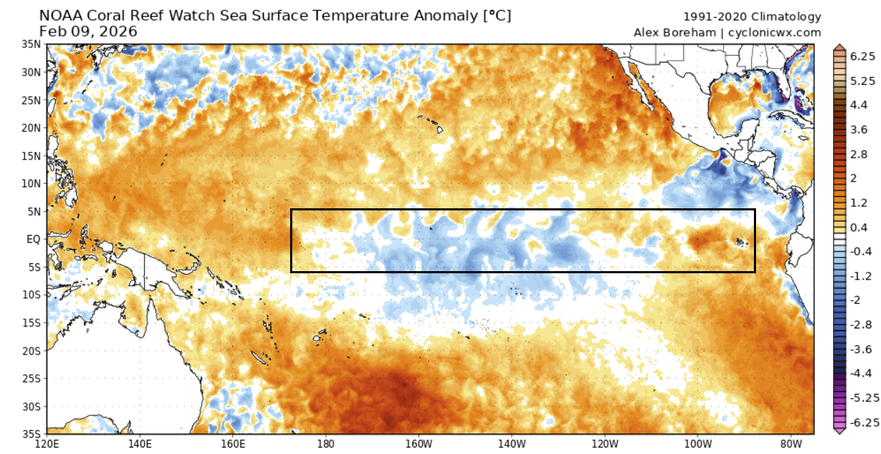
The latest ocean analysis below shows the main ENSO region that we currently watch. You can see weaker (leftover) cold La Niña anomalies, getting dissolved from both sides to the east and west. A warmer anomaly is starting to establish in the eastern parts, making progress towards the west. Image from Cyclonicwx
The whole process is nicely reflected below in the latest 30-day ocean temperature change map, where you can see a strong warming trend across the whole ENSO region. A stronger burst of warming is seen in the eastern parts, driven by the weakening trade winds, spreading the warm anomalies west.
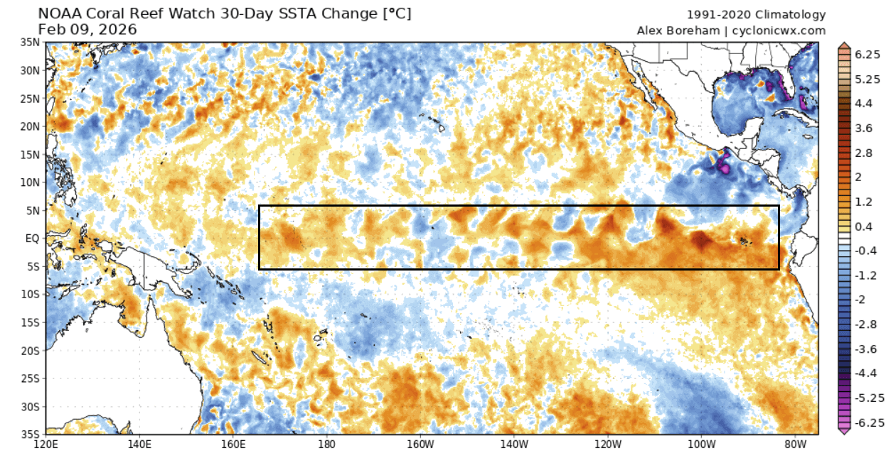
This is much better seen in the video below, which shows the last 30 days of ocean temperature changes in the ENSO region. You can see a healthy La Niña event at the start, and how rapidly it has been dissolving in recent weeks.
But while the La Niña dissolves, a new phase is already starting to emerge in the long-range forecasts, causing a major shift in the global weather system in 2026.
A 2026 Global Weather Shift: The El Niño Emerging
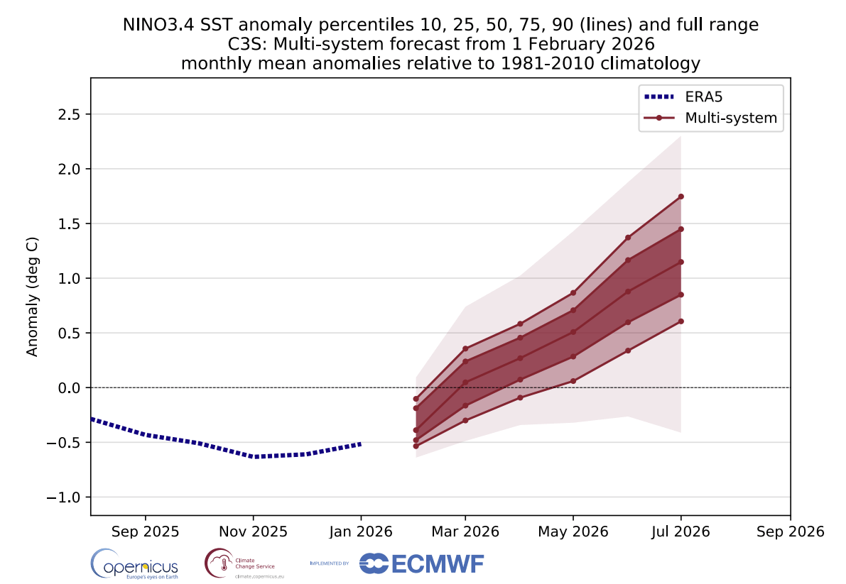
Looking at the latest long-range forecasts, we can see a clear indication of the end of La Niña and a rapid transition into a new El Niño event as soon as Summer.
Below is the newest ENSO multi-model outlook from the C3S forecast system. You can see the end of the La Niña and a rapid transition into a new El Niño by summer. This is a combined forecast from multiple long-range models, increasing the forecast confidence. This means that most forecasts agree on the rapid emergence of a 2026/2027 El Niño event.
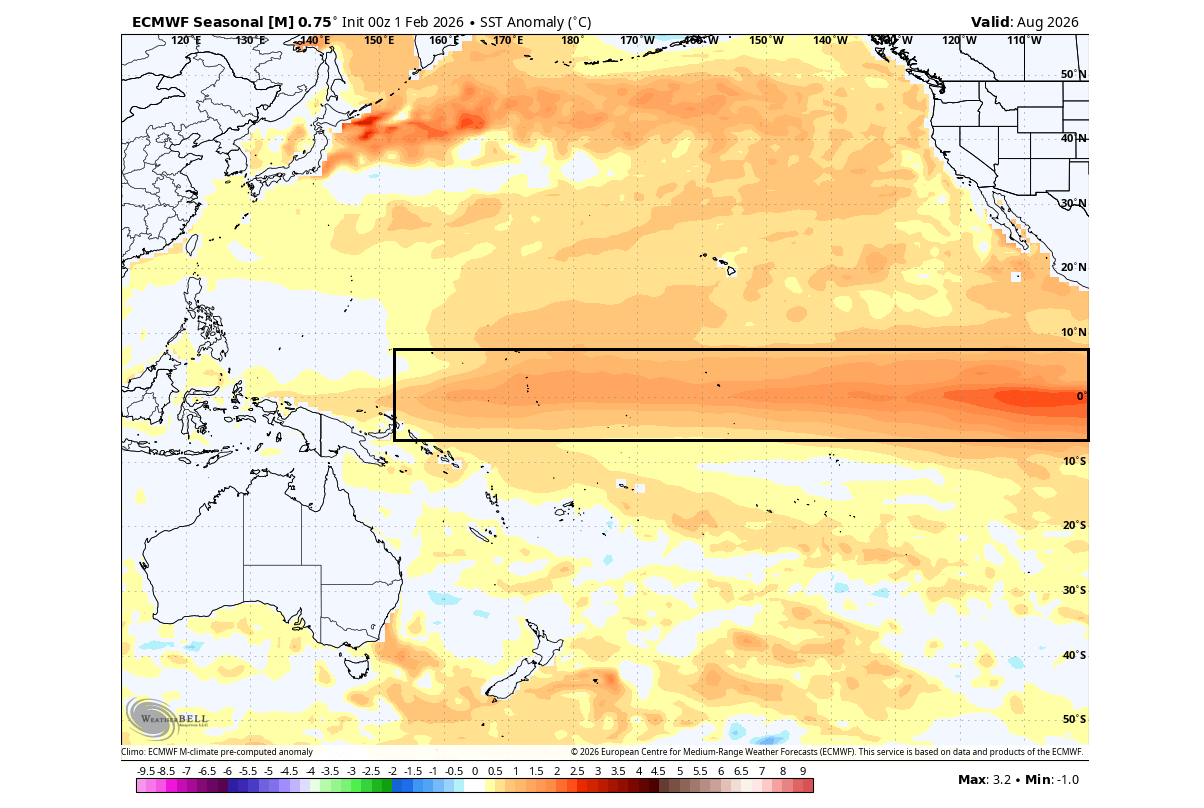
Looking at the latest long-range model forecast for August, you can already see a clear El Niño warm anomaly developing across the tropical Pacific by late Summer. This already shows the El Niño signature anomaly, with stronger development usually expected in the Fall season.
All these forecasts show a very clear and rather rapid transition from a cold to a warm ENSO phase. This tells us that we are heading for a strong global weather shift in 2026.
For this reason, we decided to look at some past data to find years with a similar shift from a weak cold ENSO phase into an El Niño. We found several such years in the past, and we merged them together to get the temperature pattern in such rapid transition years.
Below is the Spring temperature anomaly in these rapid transition years, made from NCAR data. You can see a cold air anomaly over Canada, reaching into the northern United States. Keep in mind that this is a 3-month average, and it still shows a cold Spring tendency for the northern and eastern United States. Individual cold events can extend across the whole central and eastern United States.
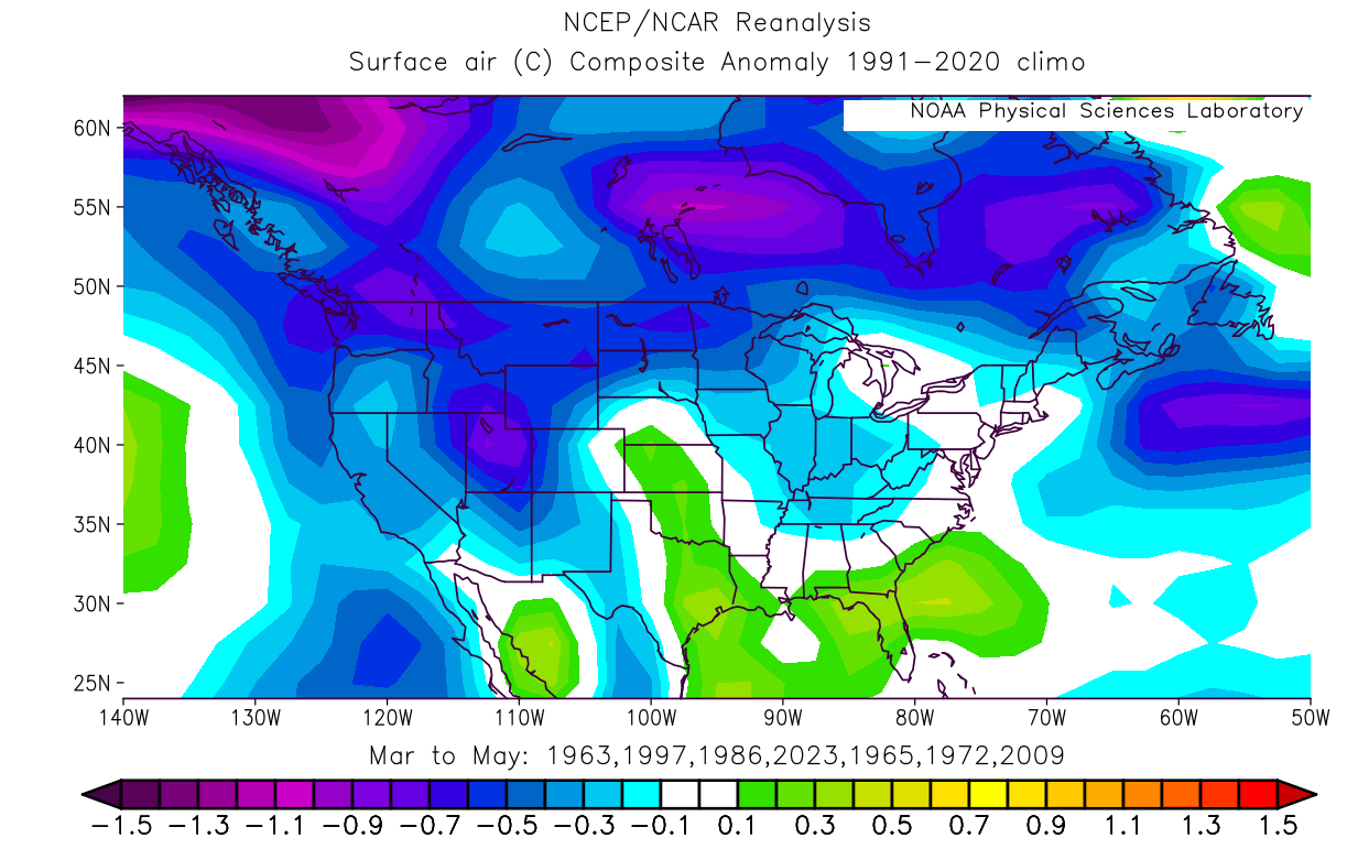
Here, I have to add that some of these years are from the past decades, which naturally exhibit a colder signal. But the overall pattern is clear, and the trend for lower than normal temperatures over southern Canada and the northern United States.
We can now look into the latest long-range forecasts to see if this signal appears over North America for Spring 2026.
Spring 2026 Temperature and Pressure Outlook for the United States and Canada
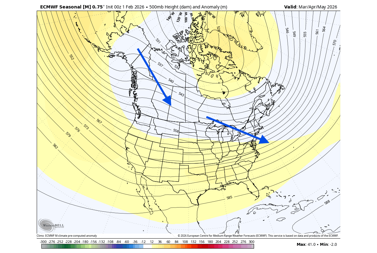
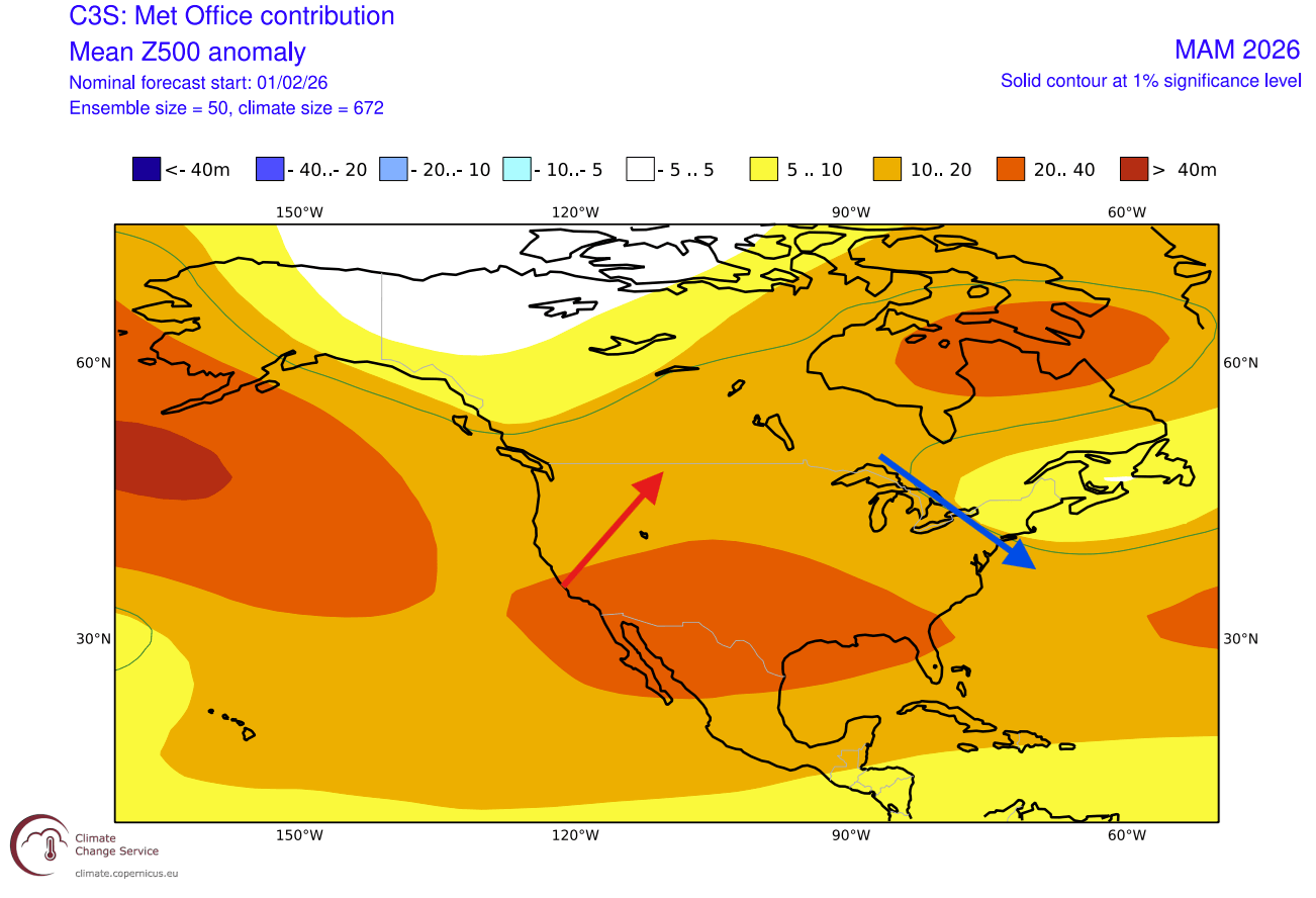
The latest pressure pattern forecast from ECMWF indicates a high-pressure system in the North Pacific, a legacy of the outgoing La Niña. In response, we see a low-pressure zone over Canada and the northern United States. When a low-pressure system sits here, that means the colder air over western Canada is closer to pushing into the United States on a northerly flow when the pattern allows it.
In Spring, the southern ridge starts to get stronger, so together with La Niña, we usually see an early onset of a warmer airmass over the southern and southwestern United States.
Below is the temperature forecast for Spring, where the forecast hints at normal surface temperatures over the northwestern United States and the upper Midwest and over most of Canada. Most of the western United States is forecast with much above normal temperatures, but the anomaly is decreasing towards the east.
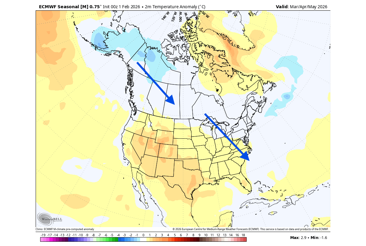
Despite being shown warmer than normal, the central parts of the United States can get occasional colder weather and snow in early Spring during a low-pressure pattern over southern Canada, as the cold air spills into the United States. But mostly warmer-than-normal temperatures are forecast over the far south and the eastern United States on a seasonal 3-month average.
The North American precipitation anomaly forecast below shows a typical late La Niña-type pattern over Canada and the United States. As a result, the United States will experience wetter conditions in the Pacific Northwest and over the East, and lower precipitation is forecast for the southwestern and southeastern United States.
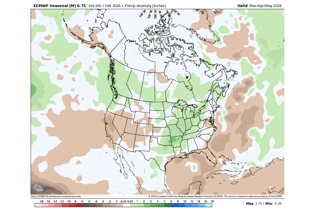
In combination with colder temperatures, this also affects the snowfall potential in early Spring. Overall, the Spring seasonal patterns look very similar to the analysis of past rapid La Niña collapse years I showed earlier above.
Comparing Models: The UKMO Spring 2026 Forecast for North America
In contrast to the ECMWF, we often use the UKMO model from the United Kingdom Met Office. This way, we can compare results, and if both models show a similar forecast, that means a higher confidence in the accuracy of the weather pattern overall.
The UKMO model agrees with the ECMWF over the North Pacific high-pressure system. A low-pressure area is shown over northwestern Canada, but a more important low-pressure area is over southeastern Canada and the northeastern United States.
This is of importance, because a local low-pressure system in that area can promote a colder northerly flow, while a southerly ridge brings up a warmer airmass in the west.
The southern ridge returns each spring over the southern United States, but is usually stronger in a La Niña season.
The temperature forecast below shows the potential northerly flow over the northeastern United States, with this category forecast indicating a neutral temperature zone. The most likely corridor of cooler air in such a pattern is from western Canada into the northeastern and eastern United States.
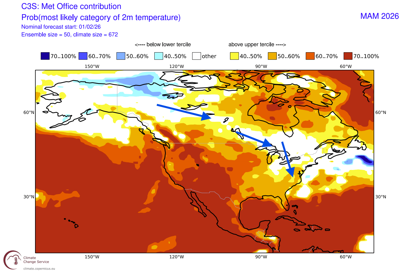
Warmer-than-normal weather prevails over the southern and western parts of the United States under the expanding spring ridge. A reduction in warm temperatures is forecast towards the eastern United States with a more active spring cold corridor.
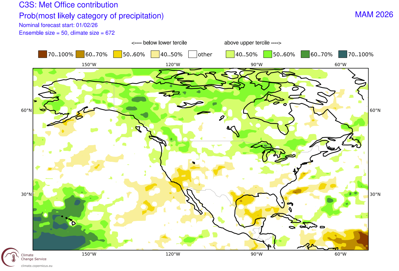
The precipitation forecast shows drier-than-normal conditions over the southwestern United States and the south coast. Over Canada, the northern United States, and the Midwest, you can see more precipitation than normal for the 2026 Spring season.
The combination of Spring cold and increased precipitation will also impact the early-season snowfall potential, which can still surprise across the northern, central, and eastern United States in Spring.
Spring 2026 Snowfall Predictions for the United States and Canada
Looking at the combined ECMWF+UKMO snowfall forecast for March, it shows above-normal snowfall over the southern half of Canada and over the northern United States. More snowfall covers the upper Midwest and also the northeastern United States.
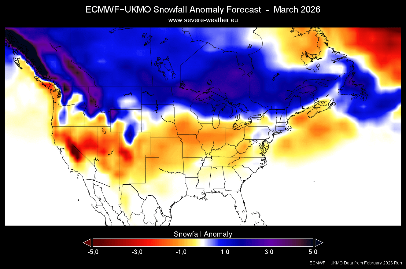
This is a pattern that reflects the past La Niña transition years, and also the stratospheric warming event impact in the first half of the month. Such proximity to cold and snow can also send individual outbreaks into the central and eastern United States, but they are usually lost in a 30-day average.
The April snowfall prediction from the merged forecast shows continuous above-average snowfall across the southern half of Canada. Less snowfall than normal for this month is forecast over the United States, but there are hints of normal snowfall in parts of the eastern United States.
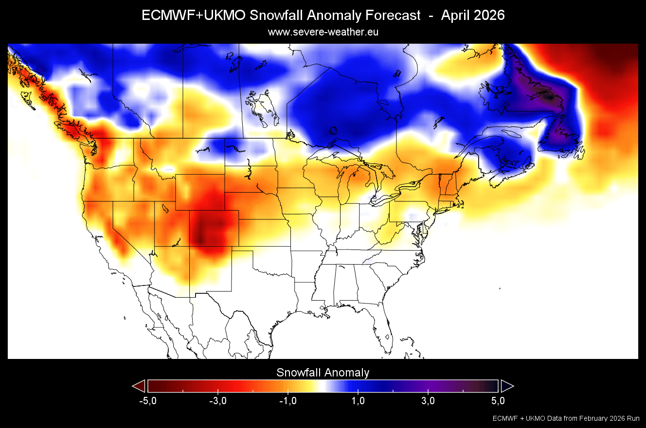
April usually shows less snowfall overall, as the temperatures start to increase and it is harder to get an overlap of cold air and precipitation. But special weather patterns like those seen in the strong La Niña-El Niño transition years seen earlier above can help to extend snow events into April.
We will keep you updated on the developing weather trends in the coming seasons, so bookmark our page. Also, if you have seen this article in the Google App (Discover) feed, click the like button (♥) there to see more of our forecasts and our latest articles on weather and nature in general.
The main forecast images in this article are from WeatherBell maps using a commercial forecaster license.
Don’t miss:
Stratospheric Warming 2026: The Polar Vortex Meets an Atmospheric Wave over North America