A new Polar Vortex is now developing in the Stratosphere over the North Pole as pressure and temperatures are already dropping over the polar regions. With the recent oceanic and atmospheric anomalies having an impact on the Polar Vortex, there are signs emerging for a dynamic Winter 2025/2026.
The Polar Vortex has a long and strong history of Winter weather impacts over the United States, Canada, and Europe. Especially when it starts to collapse in the middle of the season, which happened several times in the past years.
We will first quickly look at why the Polar Vortex is so important for Winter weather, and why we monitor it so often. Then we will look at its current development and all the factors that could turn the Polar Vortex into one of the major players for shaping the Winter 2025/2026 weather across the Northern Hemisphere.
THE NORTHERN POLAR VORTEX
Every year, as we head into autumn, the polar regions start to cool down. This is because the Sun gets lower, and less energy reaches the North Pole. But while the polar temperatures drop, the atmosphere further south is still relatively warm.
This causes a strong temperature difference between the polar and subtropical regions, which starts to create a large low-pressure (cyclonic) circulation across the Northern Hemisphere. It extends from the surface layers high up into the atmosphere. This is known as the Polar Vortex.
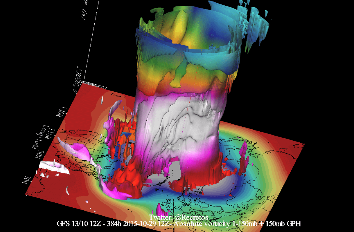
The image below shows a 3-dimensional image of the Winter Polar Vortex. The vertical axis is greatly enhanced for better visual presentation. You can see the actual structure of the Polar Vortex, connecting down to the lower levels to the pressure systems.
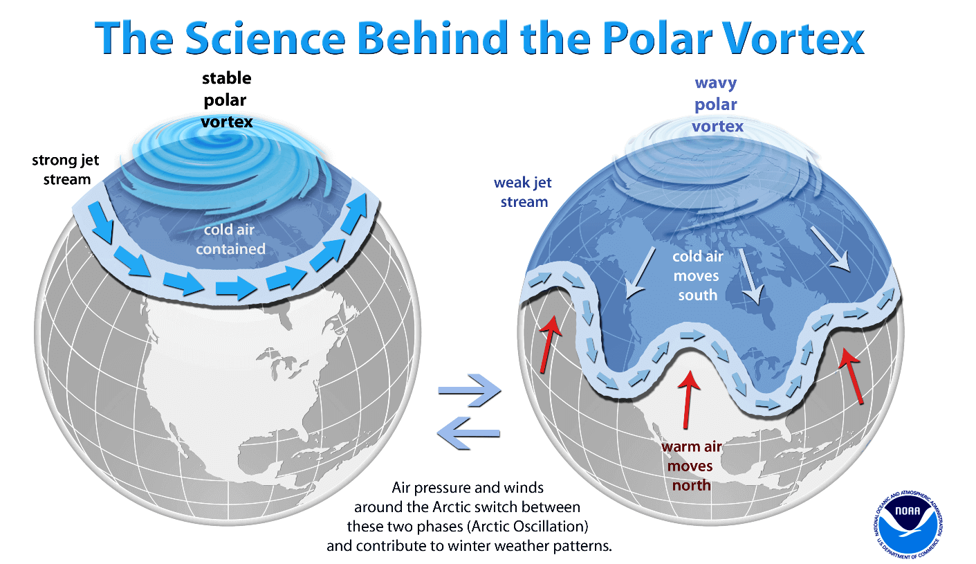
For this reason, we tend to separate the entire Polar Vortex into an upper (stratospheric) and a lower (tropospheric) part. They both play their role differently, so we monitor them separately. But it is also very important how they are connected. Image below by NOAA-Climate.
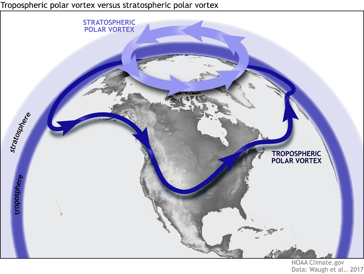
The upper (stratospheric) part of the Polar Vortex is more symmetrical and stronger, as it spins higher above the ground. But the lower structure is much more uneven and “wobbly.” That is due to the influence of the terrain/mountains and strong pressure systems acting as obstacles in the flow.
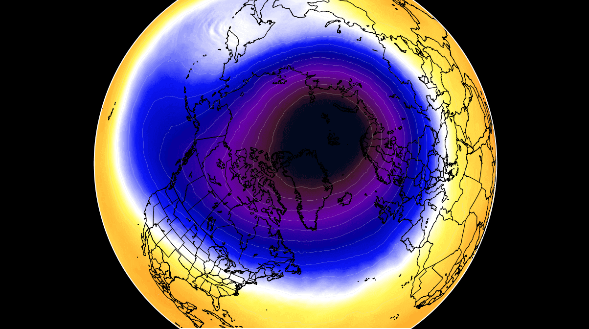
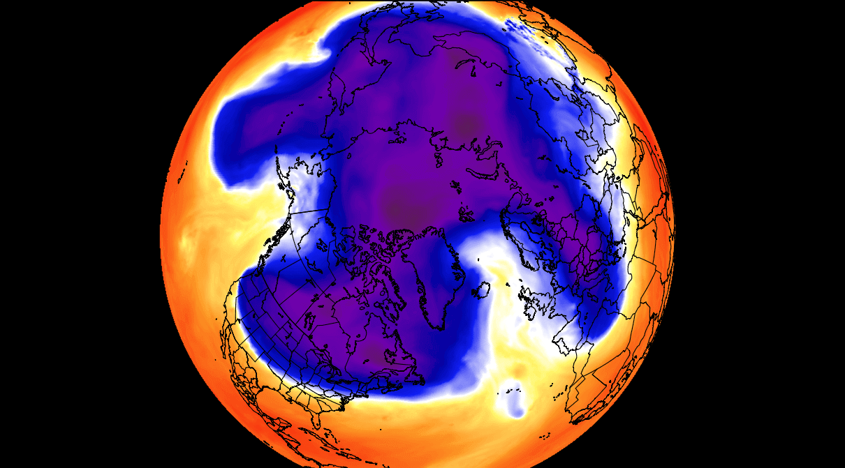
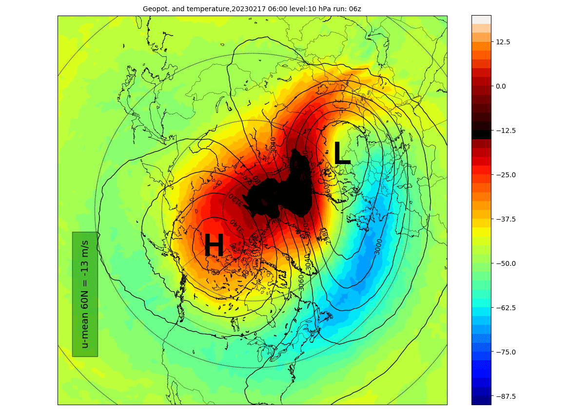
In the image below, you can see an example of the high-altitude Polar Vortex at the 10mb level (30km/18.5miles) in the middle Stratosphere during Winter. It is circular in shape, with the temperature dropping quickly towards its cold inner core. This is a rather textbook example of a healthy stratospheric Polar Vortex.
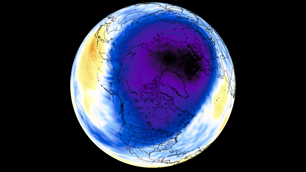
In the next image below, you can see the lower layers of the Polar Vortex at around 5km/3miles altitude. The closer to the ground we go, the more deformed the Polar Vortex gets. That is due to the influence of the terrain/mountains and strong pressure systems acting as obstacles around the Northern Hemisphere.
Notice the cold “arms” extending colder air and snowfall into the lower latitudes. These arms pack a lot of energy and can create strong winter storms and arctic outbreaks across the United States and Europe. These cold arms can, in many cases, reflect what the upper (stratospheric) part of the Polar Vortex is doing.
A question now arises: Why do we care about the Polar Vortex every Winter?
The answer is actually quite simple. This stratospheric polar circulation, called the Polar Vortex, can mean the difference between a very cold and snowy winter and a Warm and dry Winter.
A strong Polar Vortex usually means strong polar circulation and jet stream. This contains the colder air into the Arctic Circle, creating milder conditions for most of the United States and Europe.
A weak Polar Vortex can create a disrupted jet stream pattern and a strong weather response. As a result, it has a harder time containing the cold air, which can now more freely escape from the polar regions into the United States or other mid-latitude regions.
So, if you are a fan of a warmer Winter across the United States, you will prefer a strong Polar Vortex. But if you like proper Winter weather with cold and snow, a weak/disrupted Polar Vortex is your best bet.
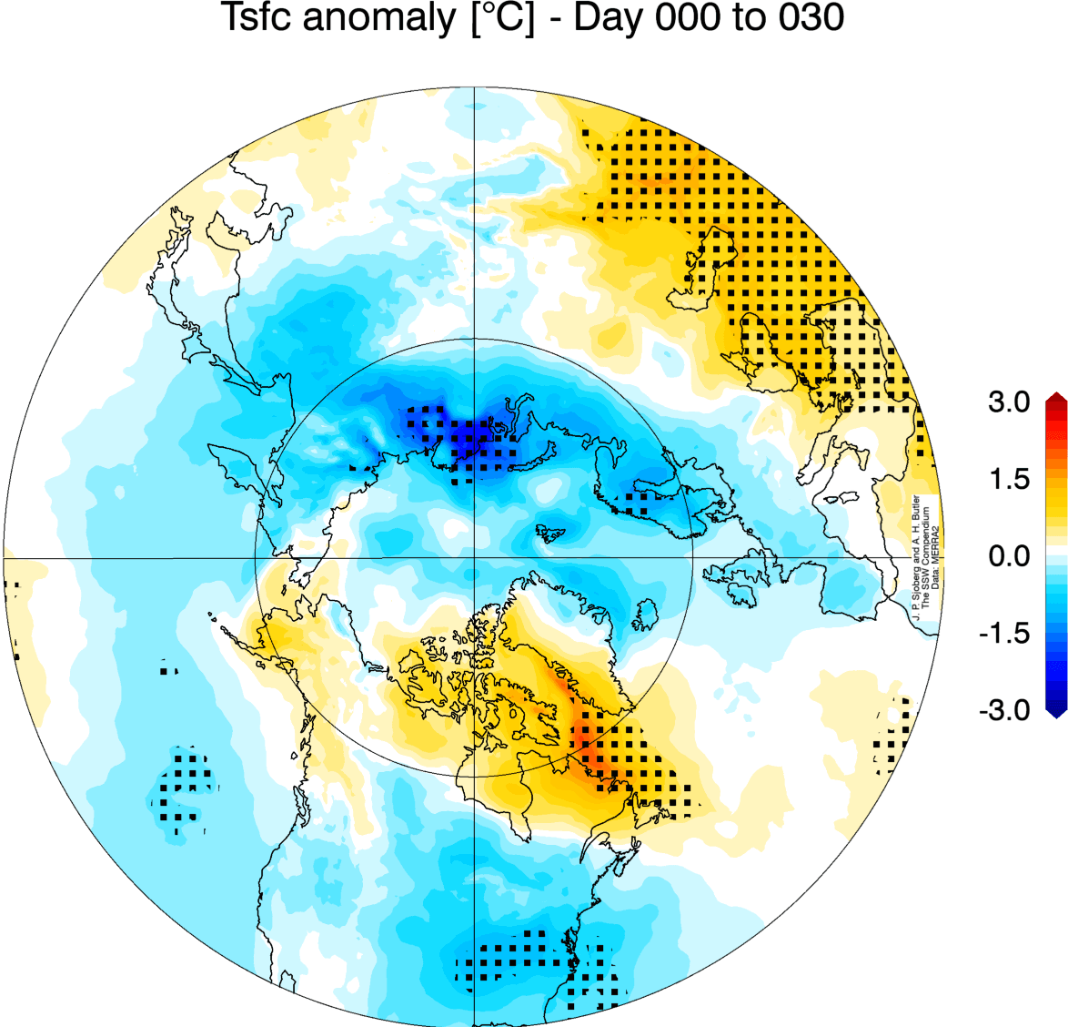
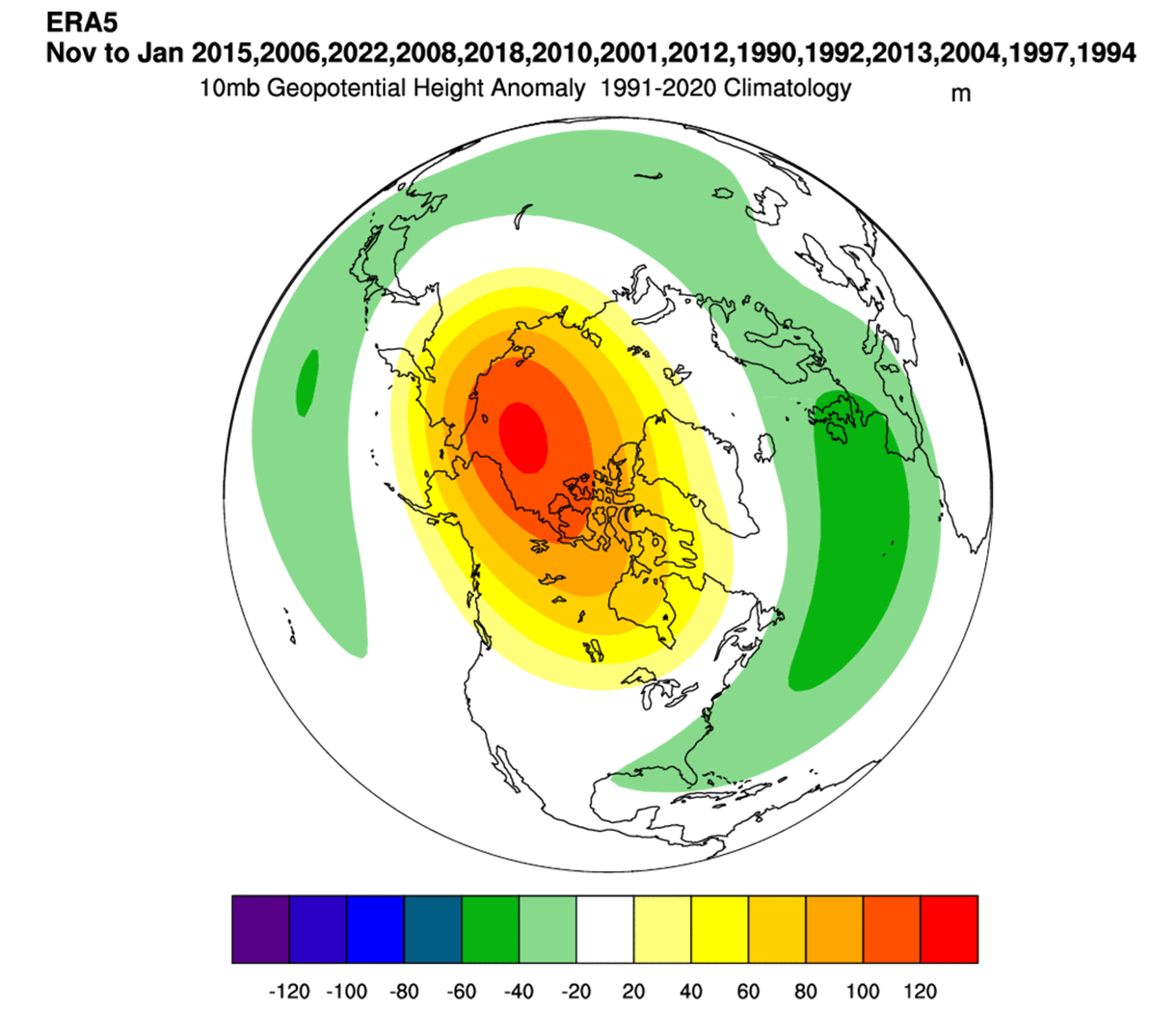
Below is the temperature anomaly 0-30 days after a fully disrupted/collapsed Polar Vortex. This is an average image of several different events, but it gives an idea of what we can usually expect behind these events. You can see a cold air release into the mid-latitudes, notably the United States and Europe.
As each year is different in the story of the Polar Vortex, we will look at the latest data in the Stratosphere and how a new Polar Vortex is starting to emerge for the 2025/2026 Winter season.
A NEW POLAR VORTEX EMERGING
The cooling over the North Pole has already begun. In the Stratosphere, the cooling usually starts in August and increases strongly over September and October. Finally, the Stratosphere reaches its coolest period in November and December, when the Polar Vortex is usually the strongest.
Below is the NASA analysis graph for wind speed in the mid-stratosphere over the North Pole. The blue line is last year, and the grey/white areas are historical data. The red square marks the month of September. You can nicely see the seasonal cycle and the rapid Polar Vortex collapse last season (green box).
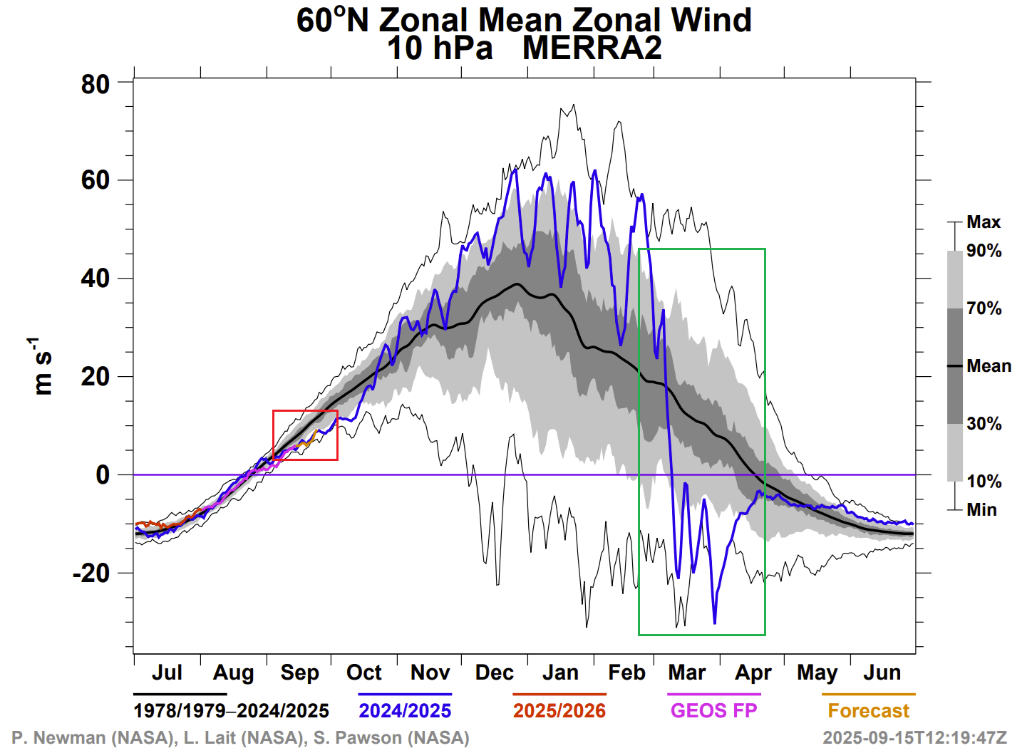
The violet/orange line shows the latest analysis/forecast. You can see that the Polar Vortex is currently running weaker than normal but at similar levels as last year (blue line). Wind speed is usually the main indicator of the Polar Vortex strength in the mid-stratosphere.
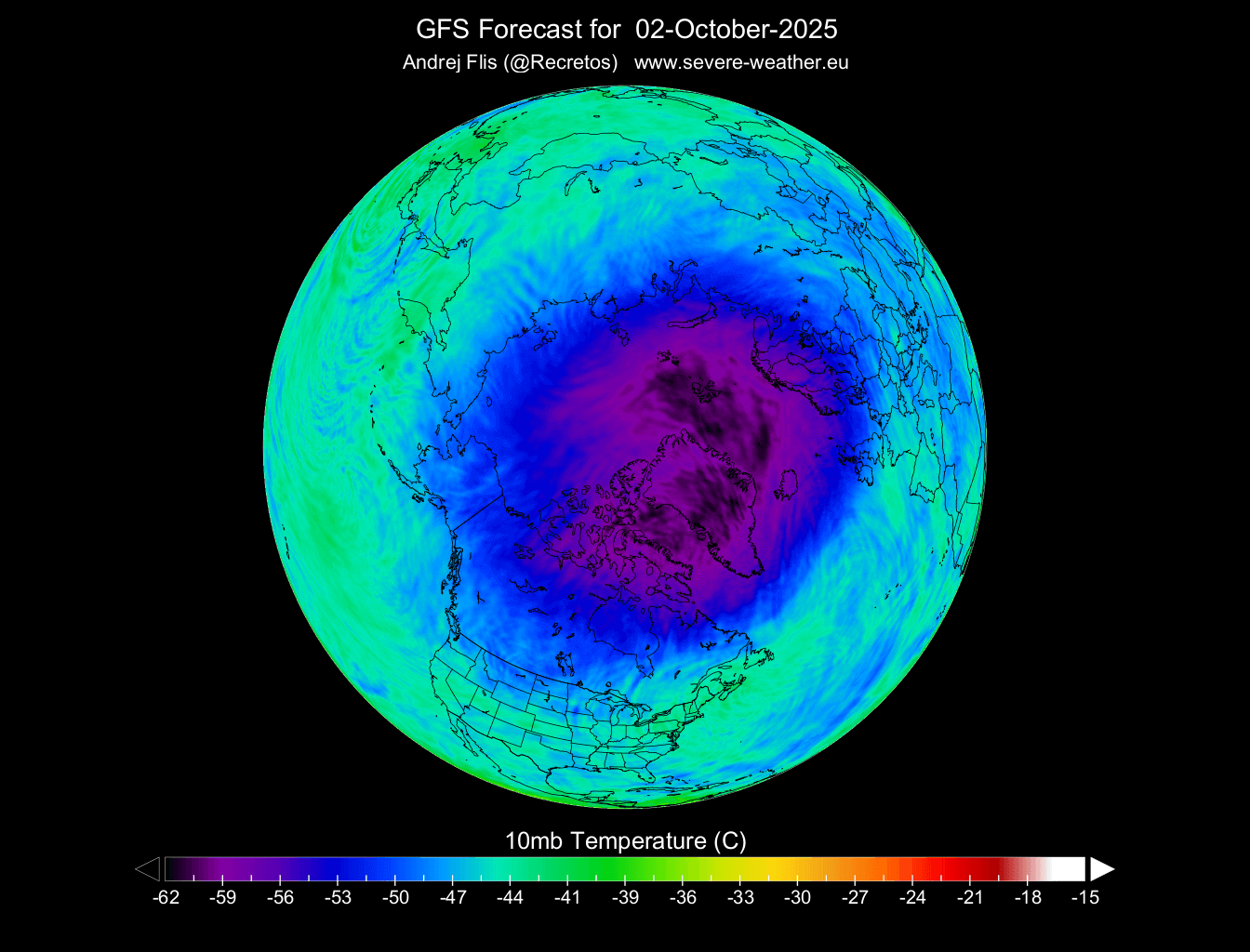
The temperature is also dropping fast in the middle Stratosphere at the 10mb level (30km/18.5miles altitude). In the image below, you can see the temperature change forecast for early October. It shows ongoing cooling over and around the North Pole, with stratospheric cooling in the next 16 days.
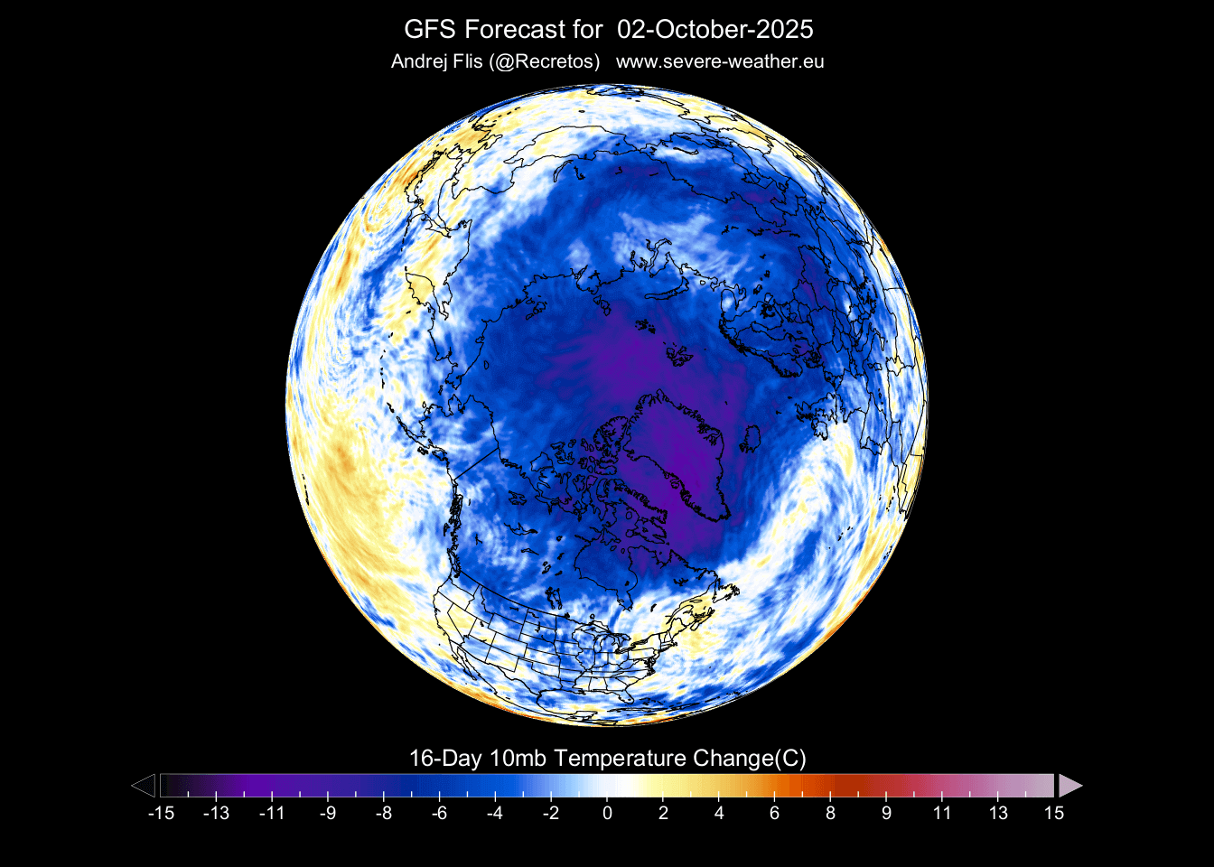
Looking at the actual temperature forecast for early October, we can see a cold core developing over/around the polar circle in the stratosphere. This is the heart of the Polar Vortex, and the colder it gets, the stronger the Polar Vortex can become.
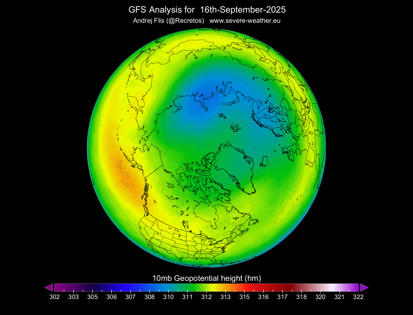
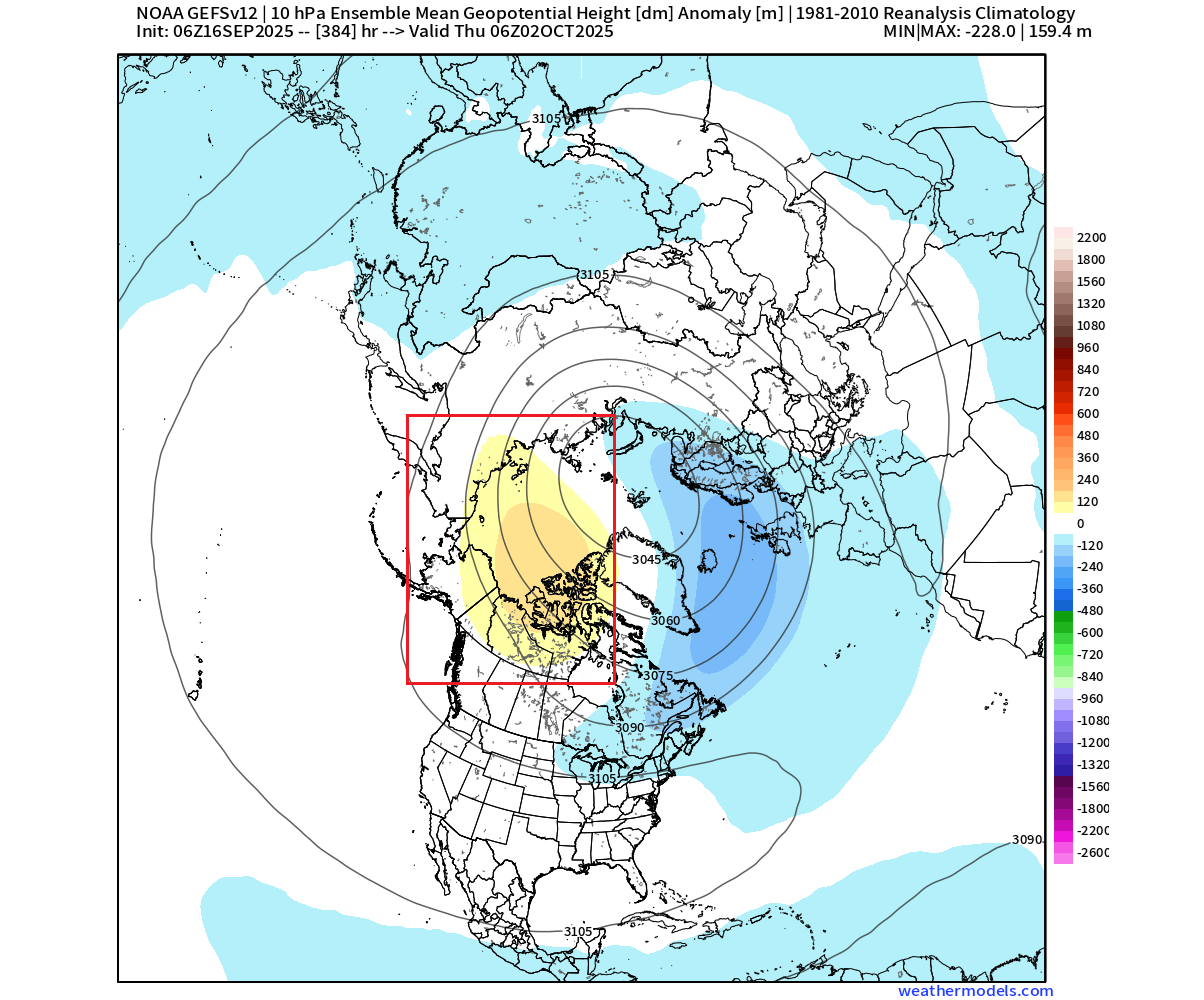
The pressure is also starting to drop rapidly. The image below shows the current geopotential height at the 10mb level (30km/18miles altitude). You can see a smaller low-pressure area that has already begun to develop over the Polar regions. That is the foundation for the Polar Vortex for the upcoming Winter 2025/2026.
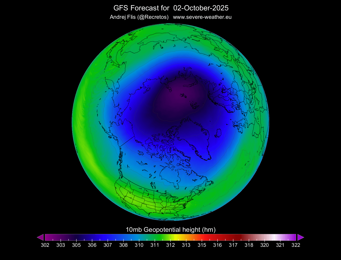
Looking below at the forecast for early October, you can see the Polar Vortex more developed and rapidly increasing in size and influence. As the pressure drops in the Polar Vortex, it increases its wind speed and depth. The stronger it gets, the easier it can influence our weather down at the surface.
To give you a better idea of how the Polar Vortex is developing, we produced a high-resolution video that shows the forecast data of the Polar Vortex growing in the stratosphere. You can see how the Polar Vortex is growing and deepening, as the northern Stratosphere drifts deeper towards the shorter nights and cooling.
Looking at the anomaly forecast for the same time and level, a high-pressure anomaly is developing over the Aleutians and into the North Pole. This will cause an early deformation of the stratospheric Polar Vortex and the stratospheric winds, keeping it at a weaker starting level.
But just as the Polar Vortex is starting to form, we can already see the first signs of trouble, which show a potential wild weather ride for the Polar Vortex in the 2025/2026 season.
POLAR VORTEX IN TROUBLE?
Two of the important large-scale factors for the upcoming Winter season are the La Niña and QBO events. One is a warm ocean anomaly in the tropical Pacific Ocean, and the second is an atmospheric wind anomaly, also in the tropics. Both factors are currently in a phase that could put the Polar Vortex in trouble.
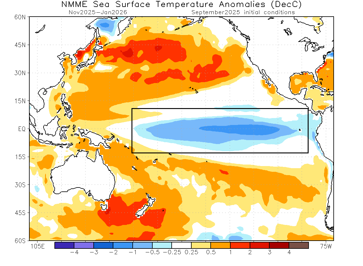
Below is the ocean temperature forecast for late Autumn and early Winter from the NMME model. You can see a large area of cold anomalies over the tropical Pacific, which is the forecasted weak La Niña. It is expected to last into early Winter 2025/2026, and weaken before Spring.
Historically, a La Niña winter has a 60-75% chance of producing a Stratospheric Warming Event (SSW), which is a complete Polar Vortex collapse and cold air release. It has produced them in the past and also in recent winters. The image below shows the typical SSW event frequency by month and by the ENSO event.
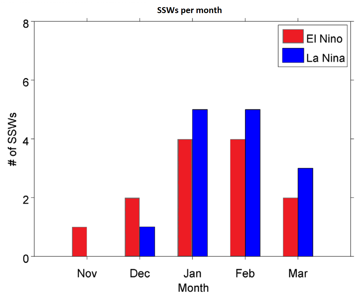
As you can see, a La Niña phase has a higher chance of producing a Polar Vortex collapse event in mid-late Winter. Overall, this means that a La Niña event is unfavorable for a strong Polar Vortex, at least on average, favoring a weak Polar Vortex season.
The second factor is the QBO (Quasi-Biennial Oscillation), which is a regular variation of the winds high above the tropical Stratosphere, shifting between easterly and westerly (zonal) winds. Around every 17 months or so, these winds completely change direction, playing a major role in the Polar Vortex development.
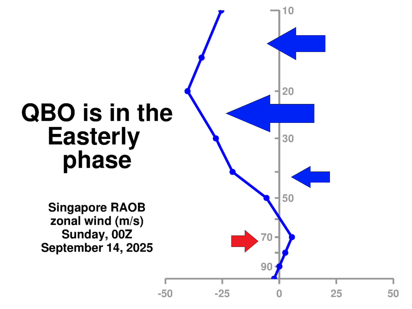
A daily radiosonde analysis shows the wind direction directly above the tropics. The latest data reveals easterly winds around the 10-50mb level, confirming the easterly/negative QBO phase is currently active and descending. It will continue to strengthen and stabilize around the 30-50mb level (21-24km or 13-15miles) as it descends towards winter.
You can see the QBO very nicely if you look at the image below, which shows the wind mode forecast for the whole globe, from the surface up to the stratosphere. In the blue box, you can see the QBO, which is currently in the negative/easterly mode. It is actually quite broad/large, and connected to both hemispheres.
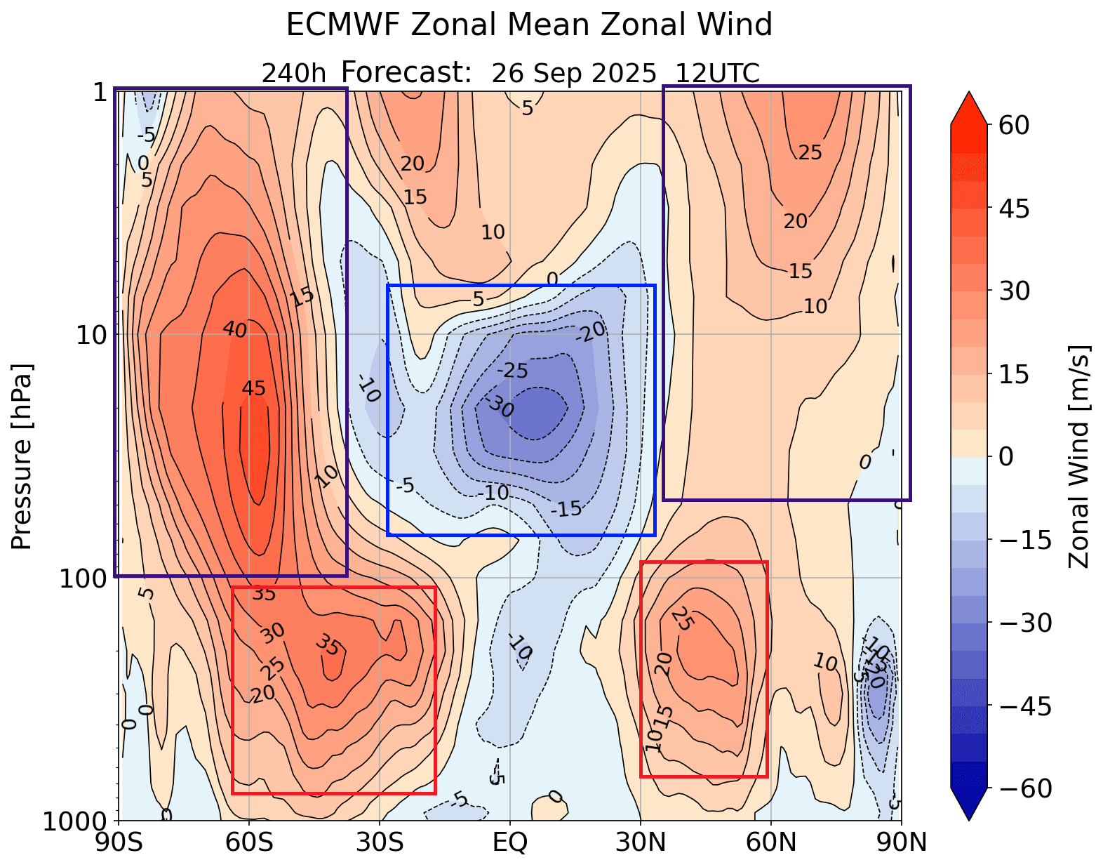
In the purple boxes, you can see the winds of the stratospheric Polar Vortex. Over the South Pole, the Polar Vortex is stronger because it’s just coming out of its winter phase, while the northerly one is just forming. The red boxes show the jet stream, and you can see how it’s connected to the stratosphere and to the Polar Vortex.
The next image below shows a stratospheric pressure analysis of several past winter years with a negative QBO. It shows a high-pressure anomaly, which means that the Polar Vortex is usually weaker and also displaced from the usual polar area. This is the second sign that the Ppolar Vortex could be in trouble for the 2025/2026 season.
To simplify, a La Niña pattern and the negative QBO are overall a bit more favorable for a weakening event of the Polar Vortex. This means that winter weather patterns can be more easily disrupted, potentially bringing colder weather and snow to the United States or other mid-latitude regions.
These are just indicators, based on past data, that show what is a likely or a potential outcome in the Winter 2025/2026 weather circulation. The current Polar Vortex is already starting out weaker than normal, which could also be another indication of what is to come.
WEAK SEPTEMBER POLAR VORTEX
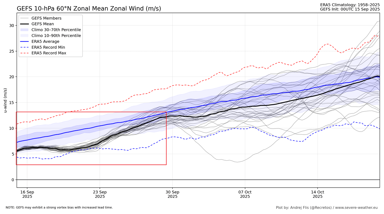
If we look at the extended range forecast of the Polar Vortex 10mb winds, you can see that it is forecast to run below normal, and even close to record low. Even before this date, the Polar Vortex was running a slow start of the season.
We decided to look at some of the past years that had weak September Polar Vortex starts. Looking at the stratosphere temperatures for January/February of the following season, we can see an interesting warm anomaly over the polar regions. This indicates a warmer/weaker Polar Vortex also in mid-late winter.
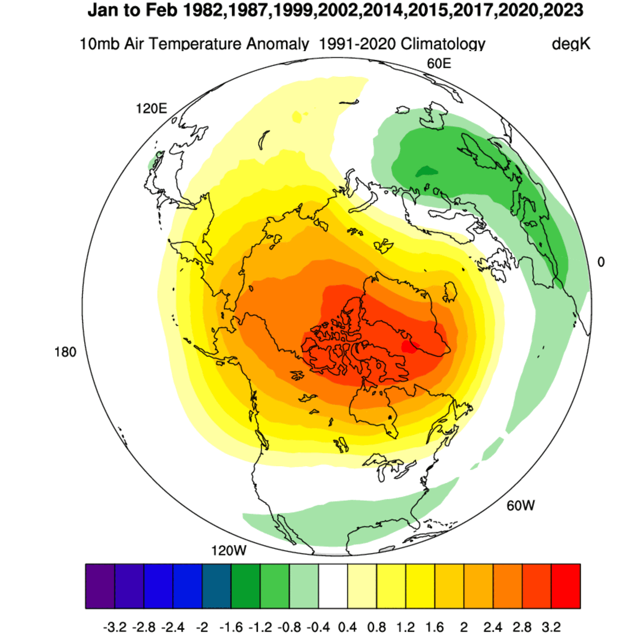
Overall, the anomaly value is weak due to the different years mixed in this composite. But overall, it does show a higher potential for a weaker winter circulation following a weak stratospheric wind in September.
This tells us an important story of how a weaker Polar Vortex in September can foreshadow a weaker Polar Vortex in Winter. More research would be needed, but there are some indications. Last year, we also had a weak September Polar Vortex, and we ended up with a Polar Vortex collapse in mid-late Winter.
Below is the latest ECMWF 2025/2026 seasonal pressure forecast from the surface up to the mid-stratosphere over the North Pole. You can see a strong high-pressure anomaly in the stratosphere, extending downward into the lower levels. This is a clear indication of a potential mid-winter stratospheric warming event.
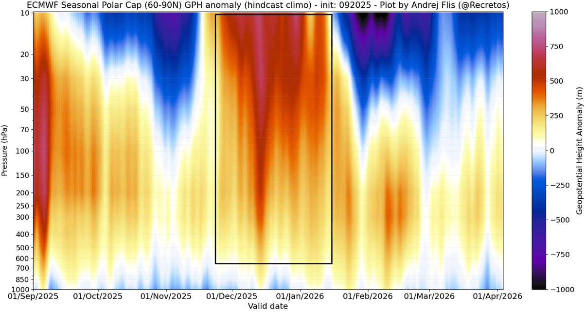
If we look at the overall context of these anomalies of temperature and pressure over the pole, we get a clear signature of a Sudden Stratospheric Warming event (SSW) likely in the 2025/2026 Winter. These high-energy events cause rapid temperature and pressure rises in the stratosphere, bringing about weather changes in the lower levels.
SUDDEN STRATOSPHERIC WARMING POWER
As mentioned, a Sudden Stratospheric Warming event (SSW) is exactly what the name suggests: a sudden temperature rise in the polar Stratosphere during Winter. Warming of the Stratosphere means that the Polar Vortex is weakened and can collapse under increased pressure from the warming event.
A collapse of the stratospheric Polar Vortex creates a chain reaction, disrupting the pressure systems below. This can create a high-pressure anomaly over the Arctic Circle, releasing cold Arctic air into the United States or Europe. A powerful SSW event occurred in February 2023 with a textbook impact.
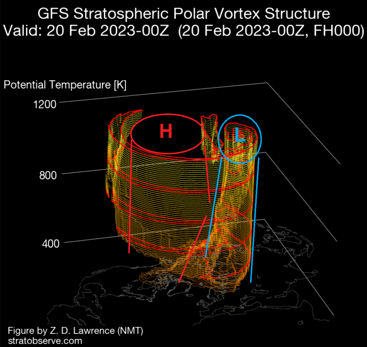
Looking at the first day of that 2023 event below, you can see a large warming wave in the mid-stratosphere. It spread over the polar regions, along with a stratospheric high (H) covering the North Pacific and western Arctic. It has displaced the Polar Vortex (L) out of the North Pole in the very first days.
You can better see the compressed Polar Vortex over Siberia (L) in a 3D analysis. This is because a strong stratospheric high-pressure area (H) has taken over the Polar Regions and severely disrupted the atmospheric circulation in the higher and middle latitudes.
The powerful disruption happened on a large scale and extended over much of the Stratosphere. Despite its power, it still took time for actual effects to filter into the lower layers and our daily weather.
The resulting pressure pattern below was fully established two weeks after the initial SSW event. The main result was a strong blocking high over Greenland, with the displaced low-pressure systems from the United States over the North Atlantic into Northern Europe.
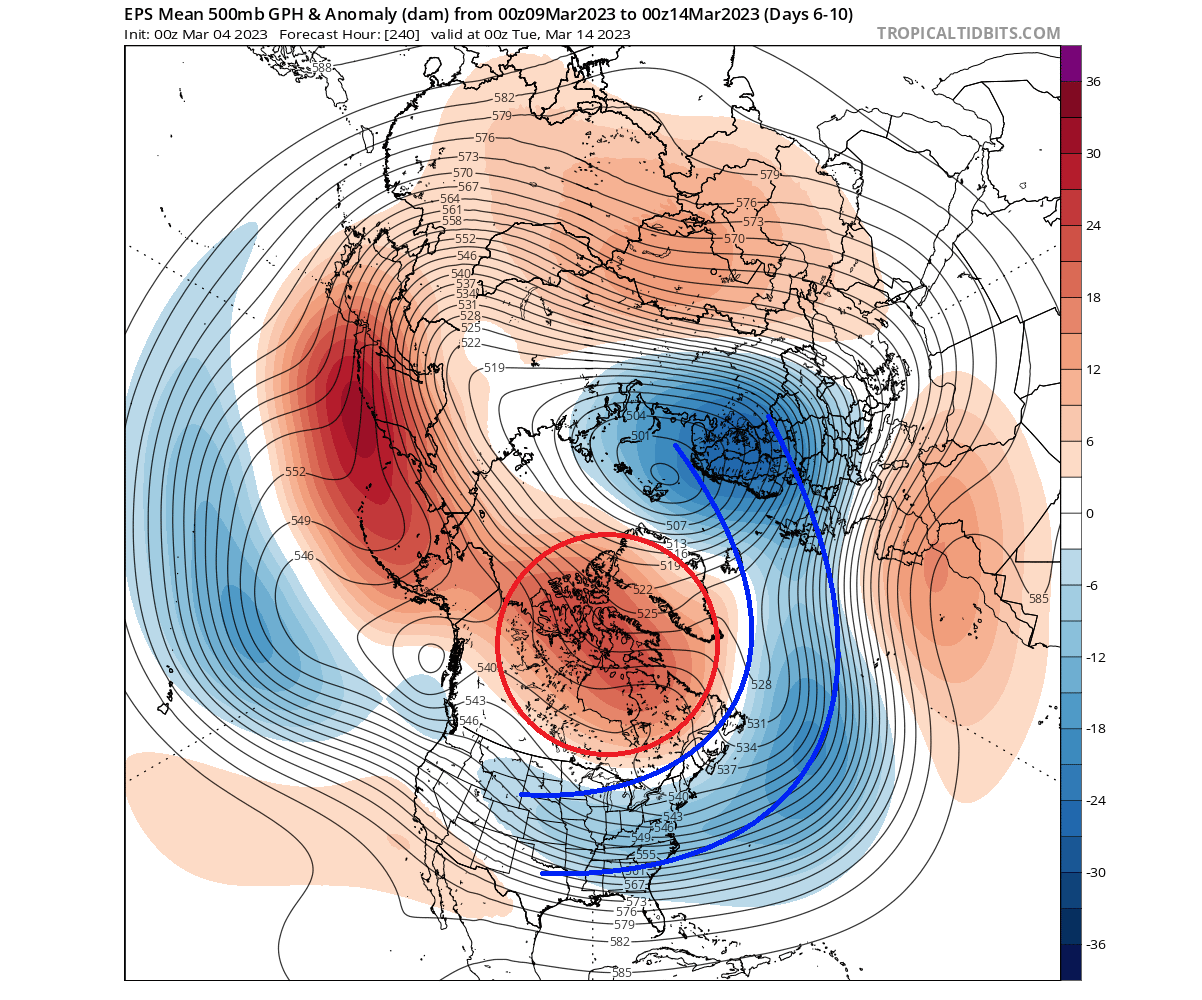
This pressure pattern is a typical weak Polar Vortex event. And as we showed in the intro, it means an easier escape of cold air down into the lower latitudes.
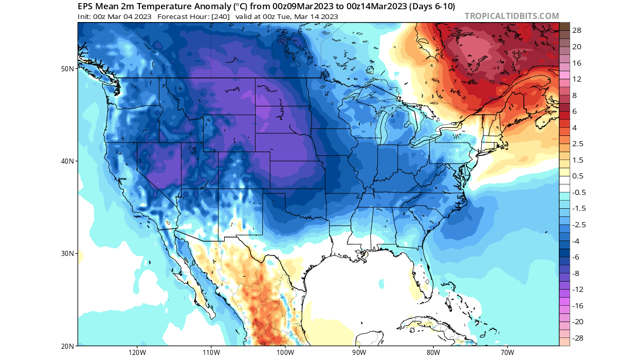
Looking at the temperature anomalies for that time, you can see a strong cold outbreak across the United States. The Greenland blocking system helps to push the cold air out of the polar regions, so a stratospheric warming event makes these scenarios much more likely (and stronger) in Winter.
As you can see, a strong or weak Polar Vortex can significantly change Winter weather in the United States, Canada, and other areas in the mid-latitudes. But the Polar Vortex is not a simple thing to forecast, as it depends on many small and large-scale factors.
A strong stratospheric warming is currently ongoing over the South Pole, with potential implications for the Northern Hemisphere as well. We wrote a full analysis in one of our articles: Stratospheric Warming event in the southern Polar Vortex, with possible far-reaching Weather impacts
We will keep you updated on the developing weather trends in the coming seasons, so make sure to bookmark our page. Also, if you have seen this article in the Google App (Discover) feed, click the like button (♥) or add us to preferred sources there to see more of our forecasts and our latest articles on weather and nature in general.