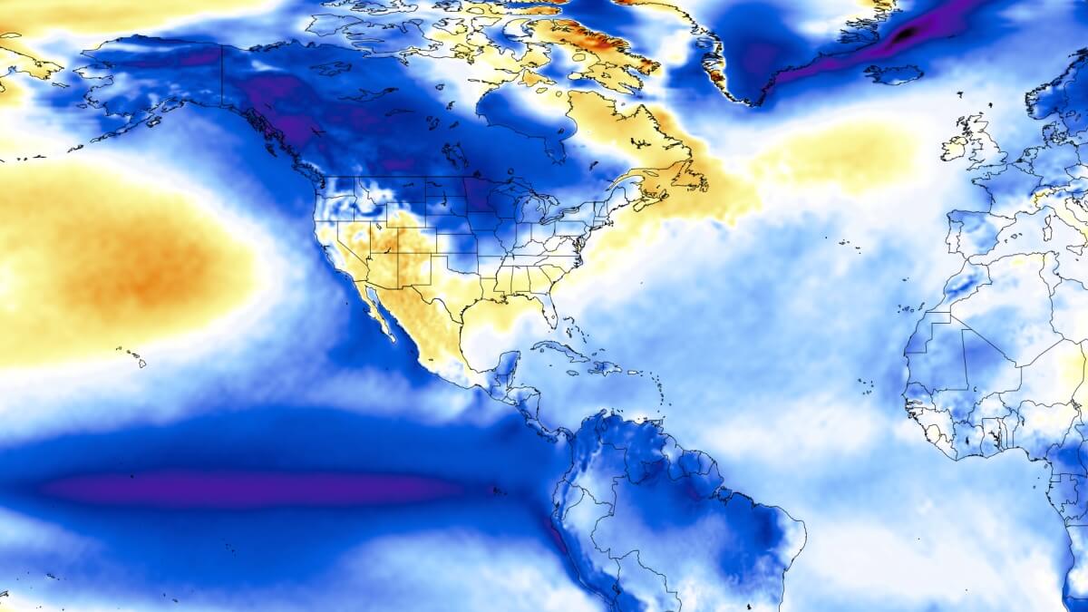
A La Niña has now formed in the tropical Pacific, prompting an official advisory by NOAA. With more ocean cooling coming during the Fall, daily weather impacts are expected for Winter 2025/2026 over North America and likely also Europe. But forecasts now show a major reversal into an El Niño event in 2026, bringing an overhaul of the global weather system
La Niña and El Niño are two phases of the same area in the Pacific Ocean, with profound impacts on global weather.
We will first quickly analyze the continued cooling in the Pacific, both above and below the ocean surface. Then we will look at the La Niña weather impacts on the upcoming Winter, the major El Niño reversal expected for 2026, and why it is significant for long-range weather development.
ENSO AND SEASONAL WEATHER
La Niña is a cold phase of the ENSO event, which stands for “El Niño Southern Oscillation.” This region of the Pacific Ocean periodically shifts between warm and cold phases. Typically, there is a phase change around every 1-3 years, but lately, the La Niña has been dominant.
Each phase (cold/warm) usually develops between late summer and Fall and lasts until Spring. But some events can last up to two or three years, as we have seen in some recent winters.
The warm phase of this area is called an El Niño. Besides the temperatures, one of the main differences between the two phases is the pressure patterns they bring, seen below as high (H) and low (L) pressure zones in the Pacific.

The pressure over the tropical Pacific is lower during an El Niño (L), resulting in more rainfall and storms in this region, as well as less precipitation over the far western tropics.
During a La Niña, pressure rises over the region (H), creating stable conditions and less rainfall over the equatorial Pacific. Pressure changes from both phases make their way into global circulation over time, affecting seasonal weather over both Hemispheres.
Each phase significantly influences tropical rainfall, pressure patterns, and the complex connections between the ocean and atmosphere. The image below illustrates the circulation pattern of a cold phase, which is currently active and is forecast to impact the upcoming Winter season. The atmospheric air motion across the Pacific is called the Walker Circulation.
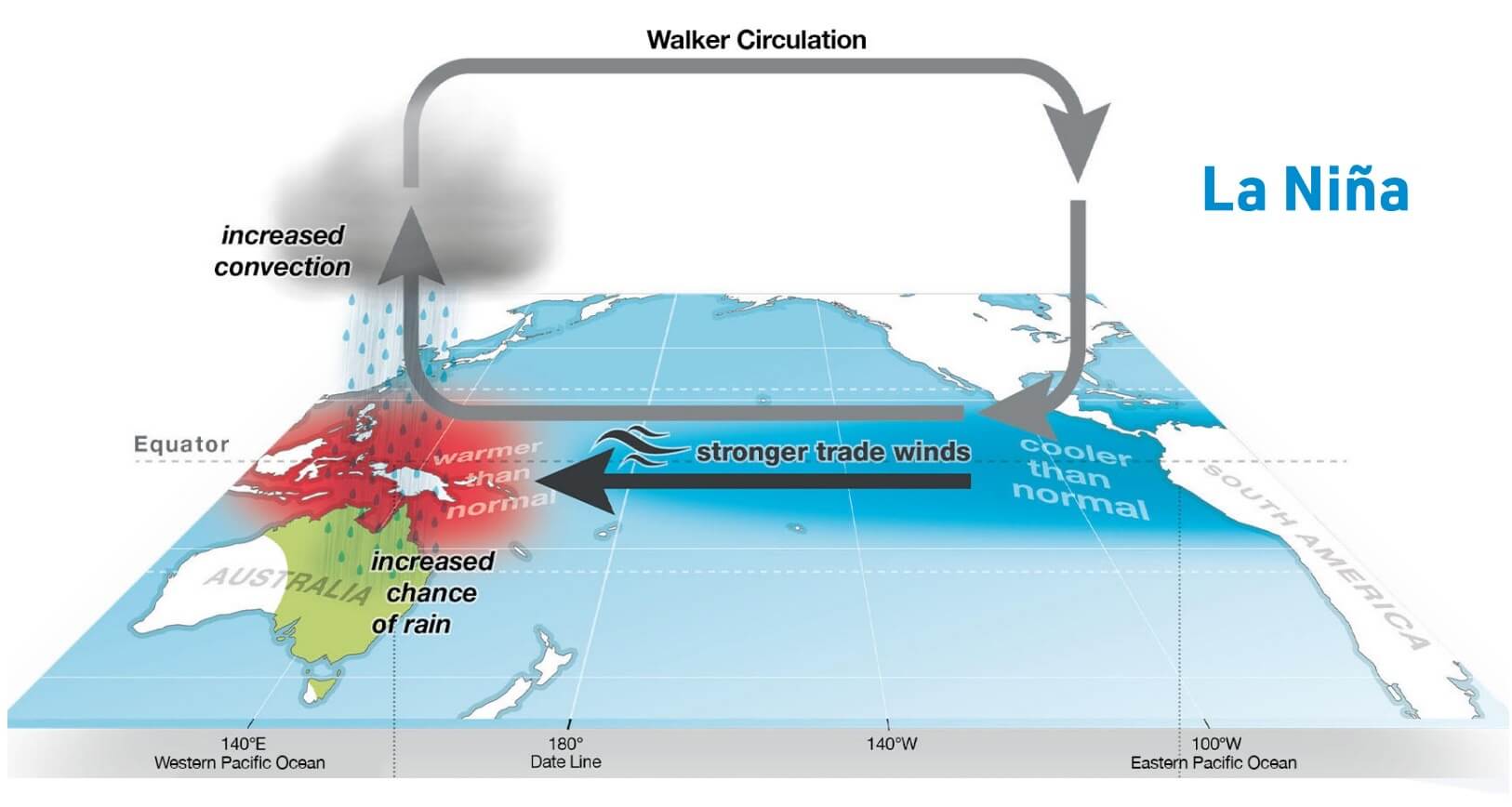
By impacting or changing this so-called Walker Circulation, ENSO significantly changes tropical rainfall and pressure patterns. This impacts the ocean-atmosphere system, which makes the ENSO influence global, shaping the Winter temperature and snowfall patterns over North America and other regions.
We are currently in an active weak La Niña phase. An official advisory was issued by NOAA as the ocean temperatures began to cool beyond the required threshold.
A NEW COLD PHASE IS HERE
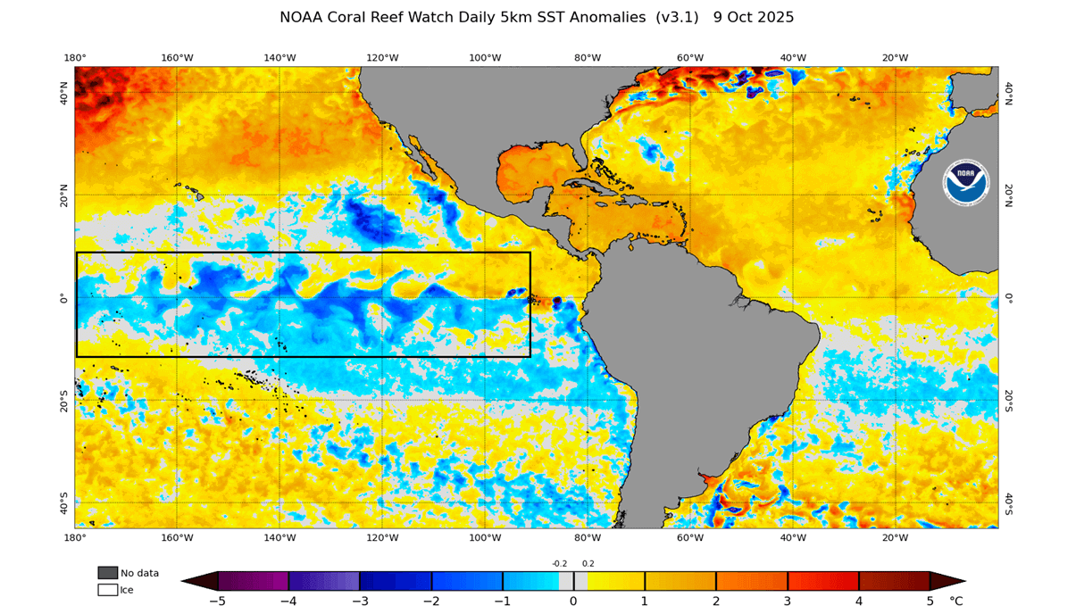
Below is the latest early October ocean temperature anomaly from NOAA CRW, and you can see a wave of cool anomalies in the marked ENSO area. This now appears to be the proper start of a new cold phase, with the average temperature in the area dropping below the La Niña threshold.
We also produced a video below, from the latest ocean data. The video shows changing ocean anomalies over the past 90 days, revealing how ocean surface temperatures have shifted in response to the easterly trade winds. Trade winds cool the ocean surface, triggering a new La Niña event for 2025/2026.
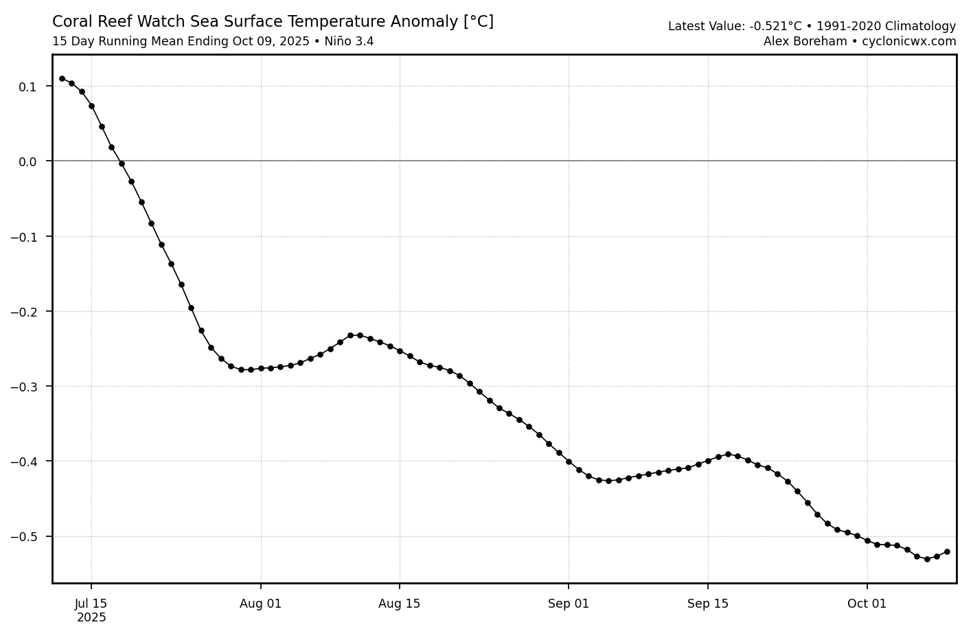
The graph below shows the 3-month ocean temperature anomaly for the main ENSO 3.4 region. It properly shows and confirms the recent cooling observed across the area. You can now see the running average dropping below the -0.5 degrees anomaly, the usual threshold at which we begin to talk about a new active La Niña event.
At this point, we also need to look at the anomalies below the ocean surface. The image below shows the ocean temperature anomaly by depth, with a large cold pool visible in the east-central tropical Pacific. This cold mass extends to depths of around 200m (650ft), and is created by a process called “upwelling”. As the name suggests, this process brings colder, deeper waters up from the depths, creating a large cold surface anomaly.
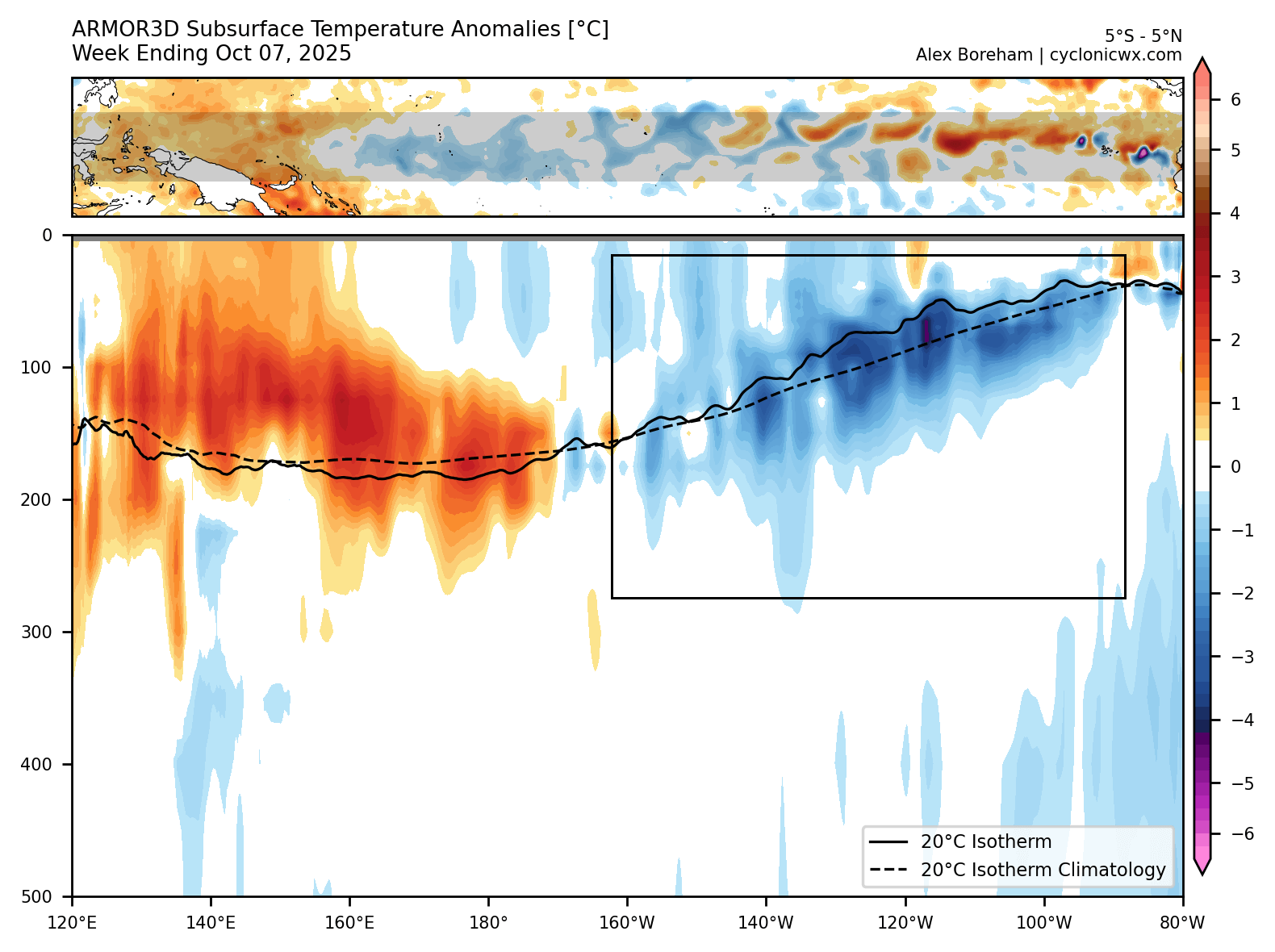
Based on the combined analysis data, it’s safe to say that a cold ENSO is now active in the Pacific, not just at the surface but also at depth.
All these changes have prompted CPC/NWS to release an official La Niña advisory for the 2025/2026 season. Below is a part of their official notice, which also states: “La Niña conditions are present and favored to persist through December 2025 – February 2026, with a transition to ENSO-neutral likely in January-March 2026 (55% chance).”
Their statement and outlook are also supported by the latest long-range forecast data, indicating a clear impact on the Winter 2025/2026 weather patterns.
SEASONAL CHANGE FORECAST
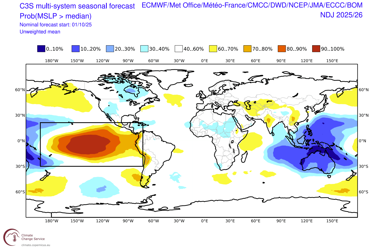
The latest round of long-range forecasts clearly shows a sustained cold anomaly in the ENSO regions, with a corresponding impact on global weather patterns. We covered this in our latest Winter 2025/2026 outlook, which includes more details on the weather patterns, and will be linked at the bottom of this article.
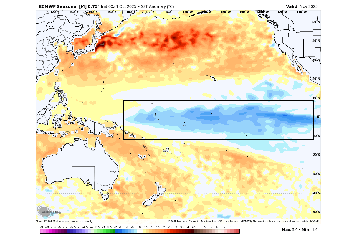
Below is the latest ocean temperature forecast for November, from the ECMWF seasonal model. You can see an area of cold surface anomalies over the tropical Pacific, indicating that a weak to moderate La Niña event is active into the upcoming Winter season.
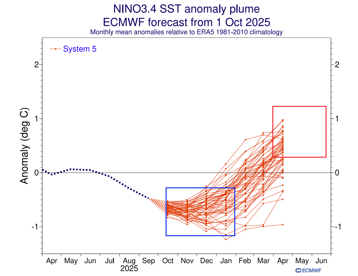
The long-range ensemble forecasts below show the forecast for the main ENSO region. The average forecast from all the calculations indicates that the cold phase will last into January, well within the La Niña limits. However, a rapid reversal into a warm El Niño phase is indicated for Spring 2026.
Looking at the atmospheric forecast from late Fall to mid-Winter, you can actually see the amplified high-pressure anomaly over the ENSO regions. There is a low-pressure anomaly over the Maritime Continent, which in total indicates a stronger Walker Circulation and a clear signature of an active La Niña mode in the atmosphere during this season, with weather impacts expected.
Even when looking at the shorter range, we can see a very clear indication that more cooling is expected in the near future. The image below shows zonal (west-east) wind anomalies over the tropical regions, indicating a large trade-wind anomaly over the Pacific, which will further stabilize the La Niña event.
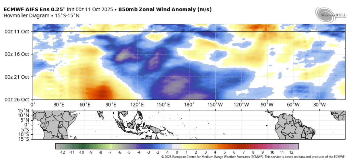
Strong trade winds push the surface waters west, creating a strong upwelling effect that we mentioned earlier. Upwelling brings the cooler, deeper waters to the surface, creating a cold anomaly on the ocean surface, which helps to sustain the La Niña.
WINTER PATTERN CHANGES
The most common effect of a cold ENSO phase (La Niña) is usually a strong blocking high-pressure system in the North Pacific. That redirects the polar jet stream down over the northern United States and southern Canada.
The image below shows the jet stream redirection during an average La Niña Winter, and the resulting weather patterns that develop over the United States and Canada. The image focuses on North America because direct impacts are observed here, unlike in Europe, where the weather patterns are not directly affected.
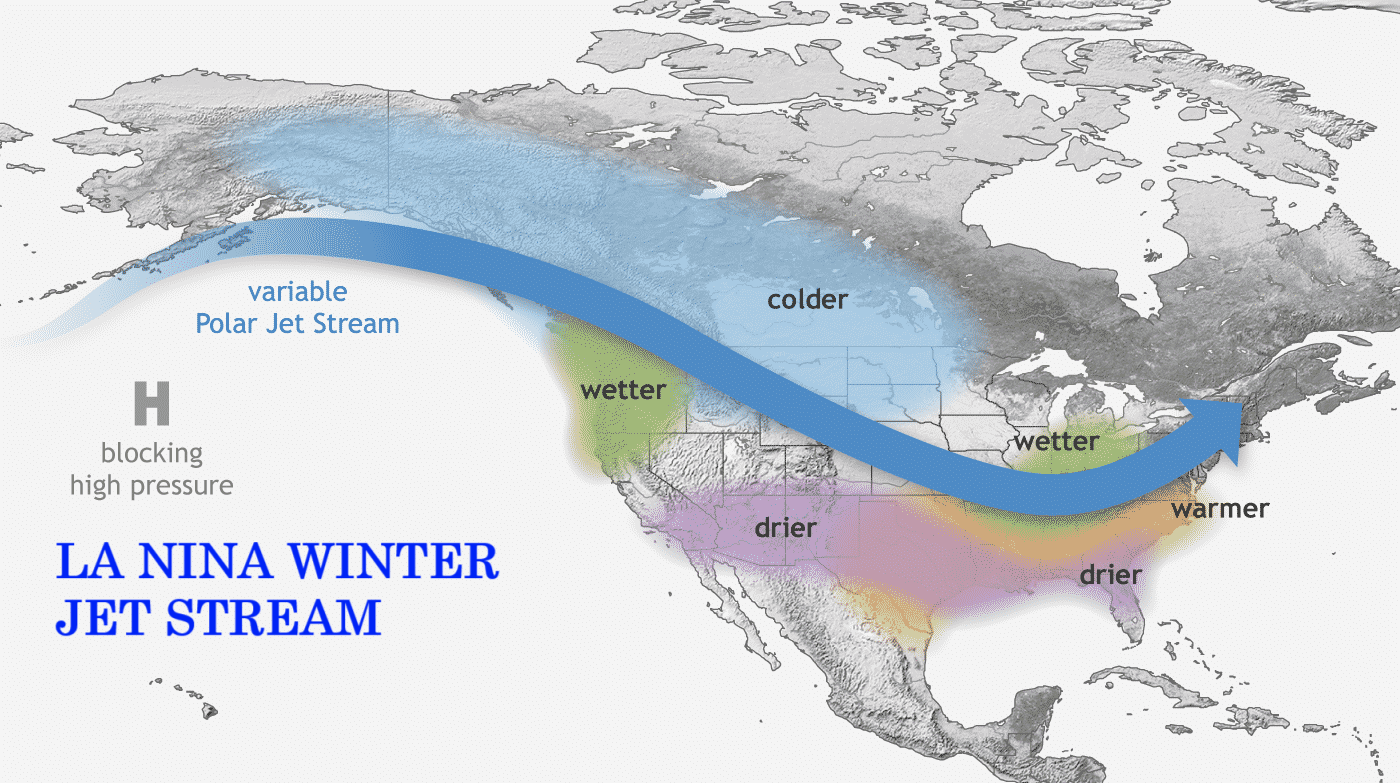
The displaced jet stream brings colder temperatures and winter storms from the polar regions down into the northern and northwestern United States. But warmer and drier winter weather prevails over the southern states.
Looking at the temperature analysis data for past weak La Niña winters, you can see the cold anomaly area under the jet stream in western Canada, extending deep into the United States. Negative anomalies also covered the Midwest and reached into the central and eastern United States, which is the usual corridor for cold air outbreaks.
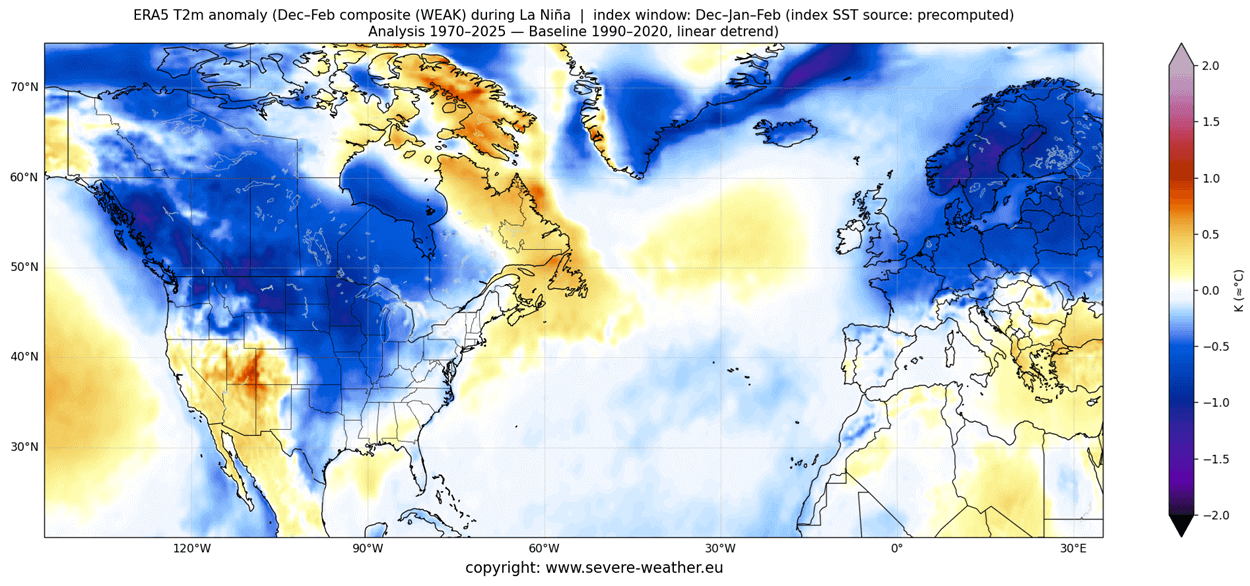
Warmer-than-normal weather and mild winter conditions are expected in the southwestern and southern United States. The main winter weather dynamics usually develop between these warm and cold anomalies in the Midwest and the east-central United States.
You can also see a colder air anomaly over the northern half of Europe. This is not something that every La Niña can provide, as this image combines some older (and colder) winters, dating back to the 1970s. But we can at least see what the average outcome was in the past, during weak La Niña winters.
With the change in the jet stream, La Niña also significantly affects snowfall potential over North America, as pressure systems take off differently.
As the colder air is more accessible to the northern United States and southern Canada during a La Niña winter, this increases the snowfall potential if/when moisture is available. In the image below, you can see the average snowfall pattern for all La Niña years.
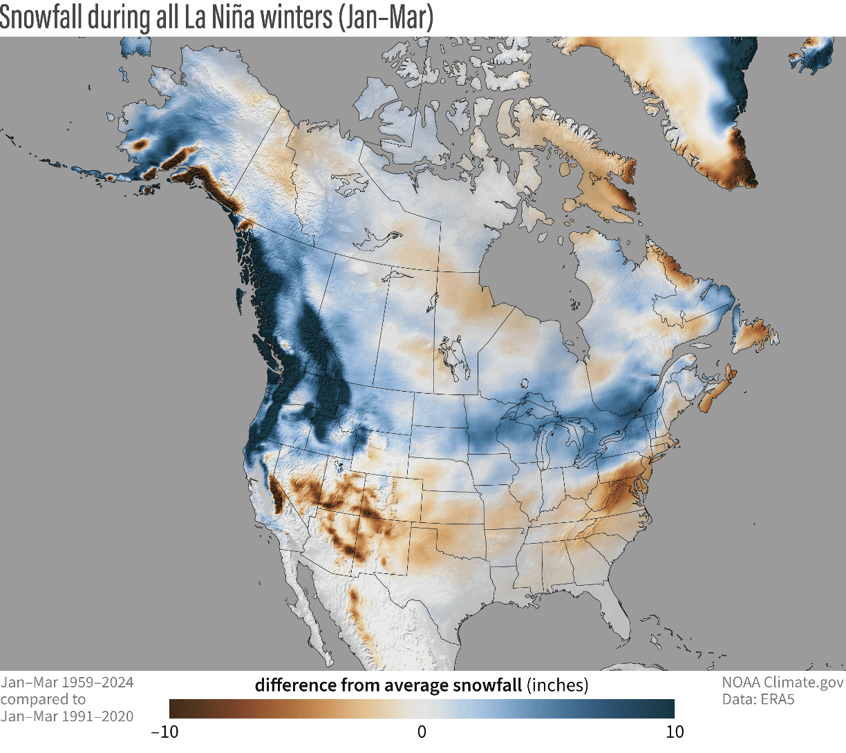
You can see above-average snowfall across much of the northern United States and southern Canada. More snowfall is also observed across the higher elevations of the Pacific Northwest. But in other areas, states like Minnesota, Wisconsin, Michigan, New York, Vermont, and northern Pennsylvania stand out with more snowfall in such winters.
A La Niña winter also has a 60-75% chance of producing a Sudden Stratospheric Warming (SSW) event, which is a complete collapse of the Polar Vortex, allowing cold air to be released into mid-latitudes. The image below shows the typical SSW event frequency by month and by the ENSO event.

As you can see, a La Niña phase has a higher chance of producing a Polar Vortex collapse event in mid-late Winter. Overall, this means that a La Niña event typically favors a weak Polar Vortex season. But why does this matter?
A weak Polar Vortex can create a disrupted jet stream pattern, leading to a strong winter weather response. As a result, it has a harder time containing the cold air, which can now more freely escape from the polar regions into the United States or other mid-latitude regions.

So, if you are a fan of a warmer Winter across the United States, Canada, and Europe, you will prefer a strong Polar Vortex. But if you like proper Winter weather with cold and snow, aweak/disrupted Polar Vortex is your best bet.
But the La Niña is not expected to become really strong or super long-lasting. The latest forecasts now indicate a very interesting El Niño signature to appear in 2026, which could play a significant role in weather development well into 2027.
EL NINO 2026 IS COMING
The first hint of a possible El Niño is already visible in the latest extended range ocean forecasts for 2025/2026. These calculations show a rather rapid reversal in the oceans, which is usually fueled by significant global weather changes.
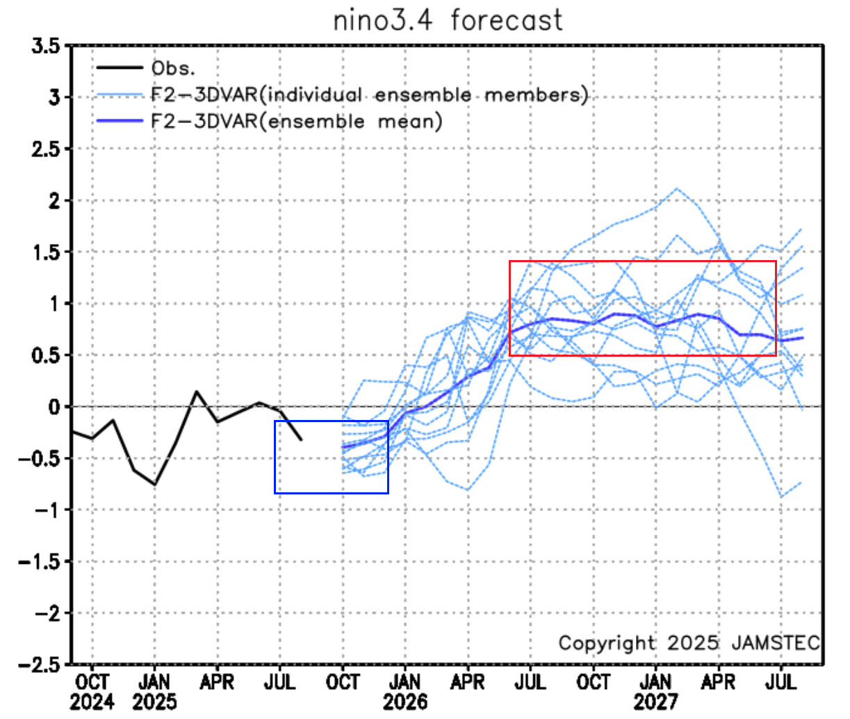
The long-range ensemble forecast below shows the forecast for the main ENSO region. The La Niña conditions (with a value of -0.5 or lower) will begin to dissipate during winter. But the extended forecast shows that most calculations shift into the warm anomalies and are also well above the 0.5 threshold of the El Niño event.
Below is also an extended analog forecast by the PSL for the main ENSO region. It clearly shows an active cold phase going into the upcoming winter, with a weakening of the cold phase toward Spring. The chances of an El Niño event increase significantly in mid-2026 and continue to rise in 2027, possibly even indicating a double or “Super El Niño” event.

Another sign of an upcoming El Niño development is provided by the atmosphere itself. Below is an image from a study by Vimont et al. (2002) on how specific North Pacific pressure patterns precede El Niño events. Below is the expected pressure pattern a few months ahead of new El Niño events.
As you can see, the main predictor pattern is a high-pressure system in the far North Pacific. Under that system is a low-pressure area, driving westerly winds across the equatorial Pacific, which limits upwelling and enables warm ocean anomalies to build.

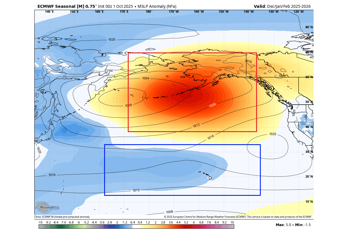
The latest EMCWF pressure forecast for the upcoming winter shows a very similar pattern. A strong surface high-pressure system with an underlying low-pressure area. This raises confidence for a proper El Niño event developing next year, which could be far stronger than the last one in 2023.
One great thing about long-range forecasting is not trying to predict the temperature 6 months from now in a nearby town at noon, as that is impossible. But we can observe and interpret the various signals provided by the oceans and the atmosphere, which can tell us a great deal about what weather patterns are coming.
So, what would an El Niño event mean for the 2026 weather patterns, especially in the next Winter?
EL NINO WEATHER IN 2026
The most typical weather effect of an El Niño is a low-pressure area in the North Pacific. That usually extends and strengthens the subtropical jet stream over the southern United States.
Before heading into winter weather, we can look at an important global image. Below is the significant impact of El Niño on crop yields and its effect on food production, resulting from global changes in pressure and rainfall patterns.
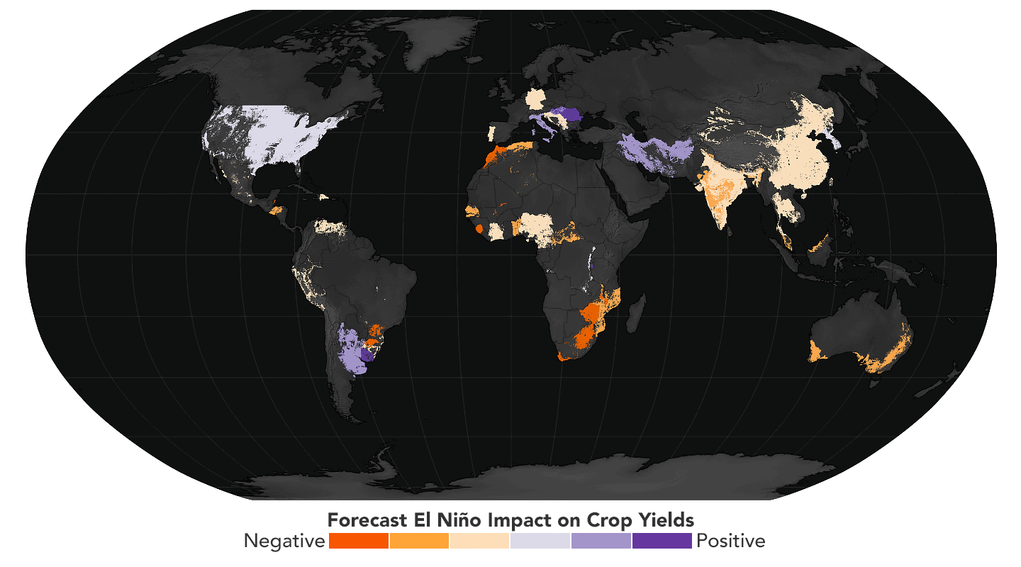
While a lot af areas show a strongly negative impact on food production, some areas do benefit from an El Niño. What stands out is a large part of the United States, which shows a slight to moderate positive impact on crop yields and food production.
Regarding winter impacts, the image below shows the average position of the jet stream during El Niño winters and the resulting weather patterns over the United States and Canada. A stronger Pacific jet stream is visible across the southern United States, resulting in an amplified low-pressure track.
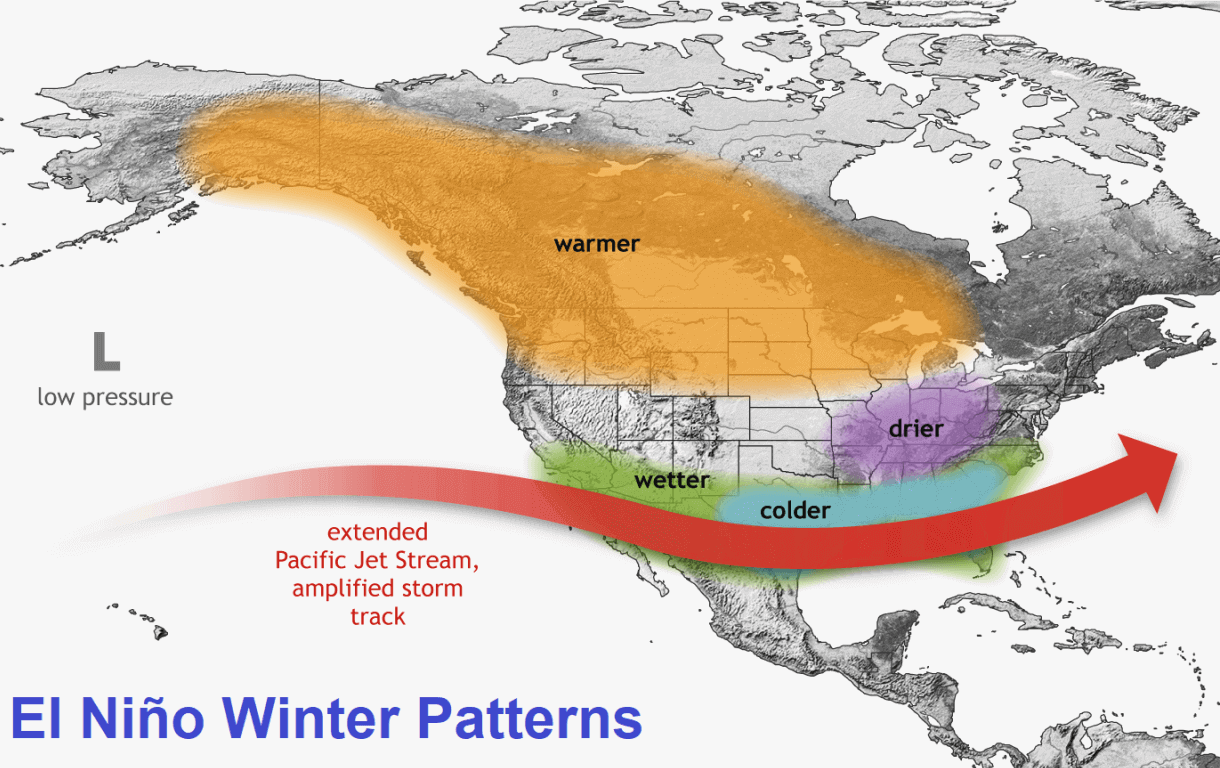
A stronger subtropical jet stream brings lower pressure, colder temperatures, and more moisture to the southern United States. If enough cold air is available, this combination also increases the snowfall potential across the central and eastern United States.
Temperatures play a significant role in snowfall potential. The image below shows snowfall anomalies during all El Niño winters since 1970. Some areas with increased snowfall during an El Niño include the southern, central, and eastern United States, as well as parts of central and northern Europe.
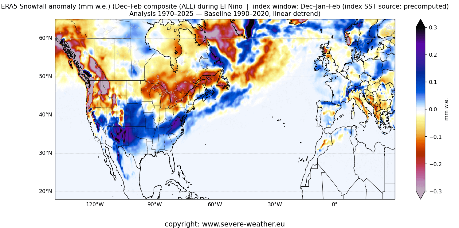
This is mainly due to low-pressure systems trailing across the southern United States. More moisture increases the chances of snowfall in the southern half, but enough colder air must be available.
Less snowfall is typically observed across the upper Midwest, the northern Rockies, the Pacific Northwest, and southeastern Canada.
Actual snowfall amounts are often limited in the southern United States because temperatures must be sufficiently cold for snow to accumulate and persist. For that reason, there is usually much more snowfall during an El Niño in the higher and colder elevations of the southwestern United States.
This is essentially just an analysis of specific past winters. But just like 1+1 equals 2, we can also see in the weather how a combination of certain global factors can produce a similar winter season more than once.
For this reason, we wrote a full article on the current global weather factors and what their past winter impacts can tell us for the upcoming winter: Analog Winter 2026/2026 Outlook
We will continue to track the latest global weather patterns and forecasts, so be sure to bookmark our page to stay up-to-date. If you found this article in the Google App (Discover), tap the ♥ or star to see more of our weather and nature coverage in your feed.