Winter 2024/2025 is just around the corner, and the latest forecast data shows proper Winter weather over the U.S. and Canada starting in December. Long-range indications show the potential for cold events remains into January and February over the central and eastern U.S.
The global weather system has many large-scale and small-scale driving factors. The main factor this year will be a weak La Niña event in the Pacific, but we also expect the Polar Vortex to play a larger role in mid-winter.
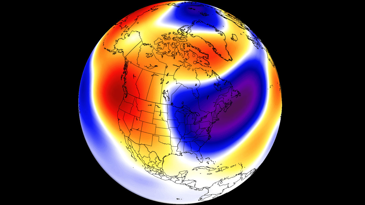
Below is an example of the upcoming pressure pattern over North America at the start of December. Such a low-pressure anomaly brings a northerly flow and colder air into northern, central, and eastern parts of the United States. This is the anomaly that we will also be looking for in the long-range period of January-March.
COLD LA NINA IS HERE
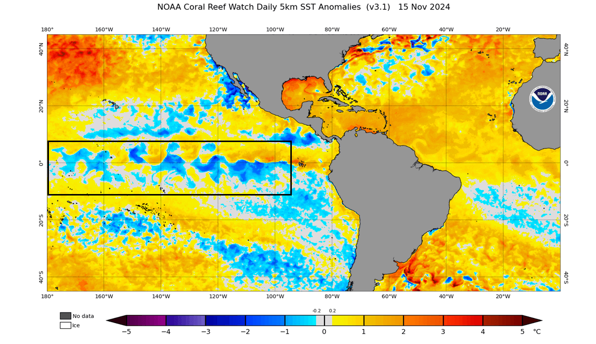
La Niña is a cold phase of the large and powerful oceanic ENSO oscillation. It is a region of the tropical Pacific Ocean that shifts between cold and warm phases. The cold ENSO phase is called La Niña, and the warm phase is called El Niño.
Below is the latest mid-November ocean anomaly analysis. It shows colder-than-normal surface waters in the central and eastern ENSO regions. These cold anomalies have a “wave-like” shape because of the strong easterly trade winds that push the waters towards the west, creating swirls on the ocean surface.
Below is an analysis/forecast image from NMME, where you can see the ocean temperature drop starting early in spring. Negative anomalies and cooling are forecast to continue into the Winter of 2024/2025. The forecast average is within the La Niña threshold but shows a weak event this season.
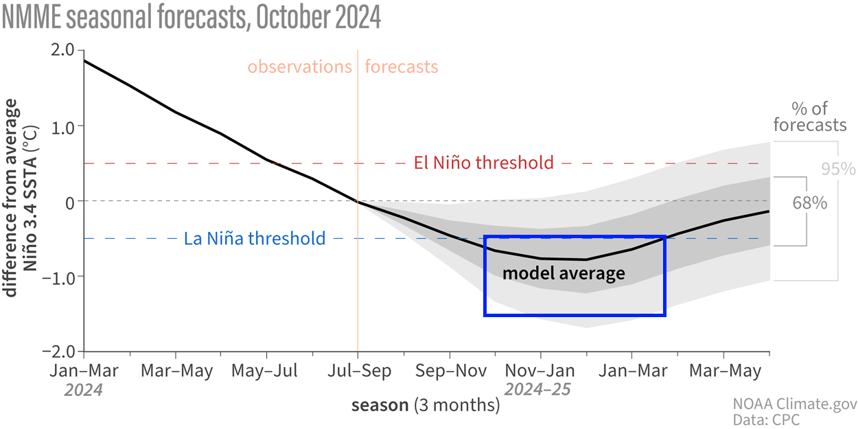
The image above shows that even in early spring, the ocean anomaly was still above normal but began cooling rapidly. We produced a high-resolution video (below) from NASA data that shows this transition of ocean anomalies in the tropical Pacific.
La Niña usually creates a high-pressure system over the North Pacific. That promotes the development of a low-pressure region over Alaska and western Canada and shifts the jet stream downwards in between the two pressure systems.
The image below shows the shift of the jet stream into the northern United States. It shows the average position of the jet stream during La Niña winters and the resulting weather patterns over the United States and Canada.
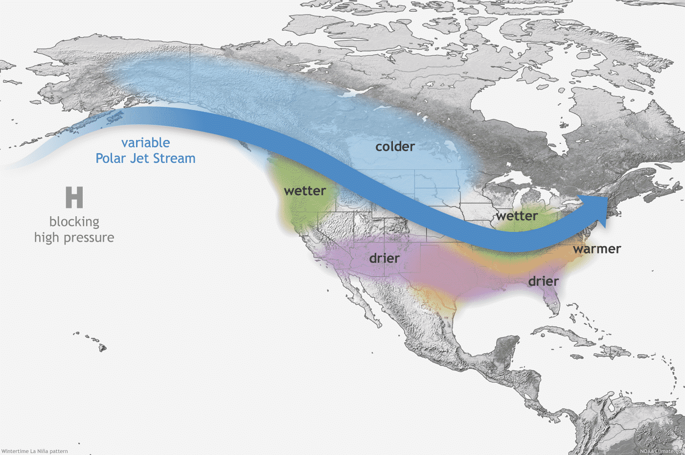
The displaced jet stream brings colder temperatures and winter storms from the polar regions down into the northern and northwestern United States. Warmer and drier winter weather prevails over the southern states.
As the colder air is more easily accessible to the northern United States and southern Canada in a La Niña winter, that increases the snowfall potential.
You can see above-average snowfall across much of the northern United States and southern Canada. Peak snowfall is usually across the higher elevations of the Pacific Northwest. But in other areas, states like Minnesota, Wisconsin, Michigan, New York, Vermont and northern Pennsylvania stand out with more snowfall in such winters.
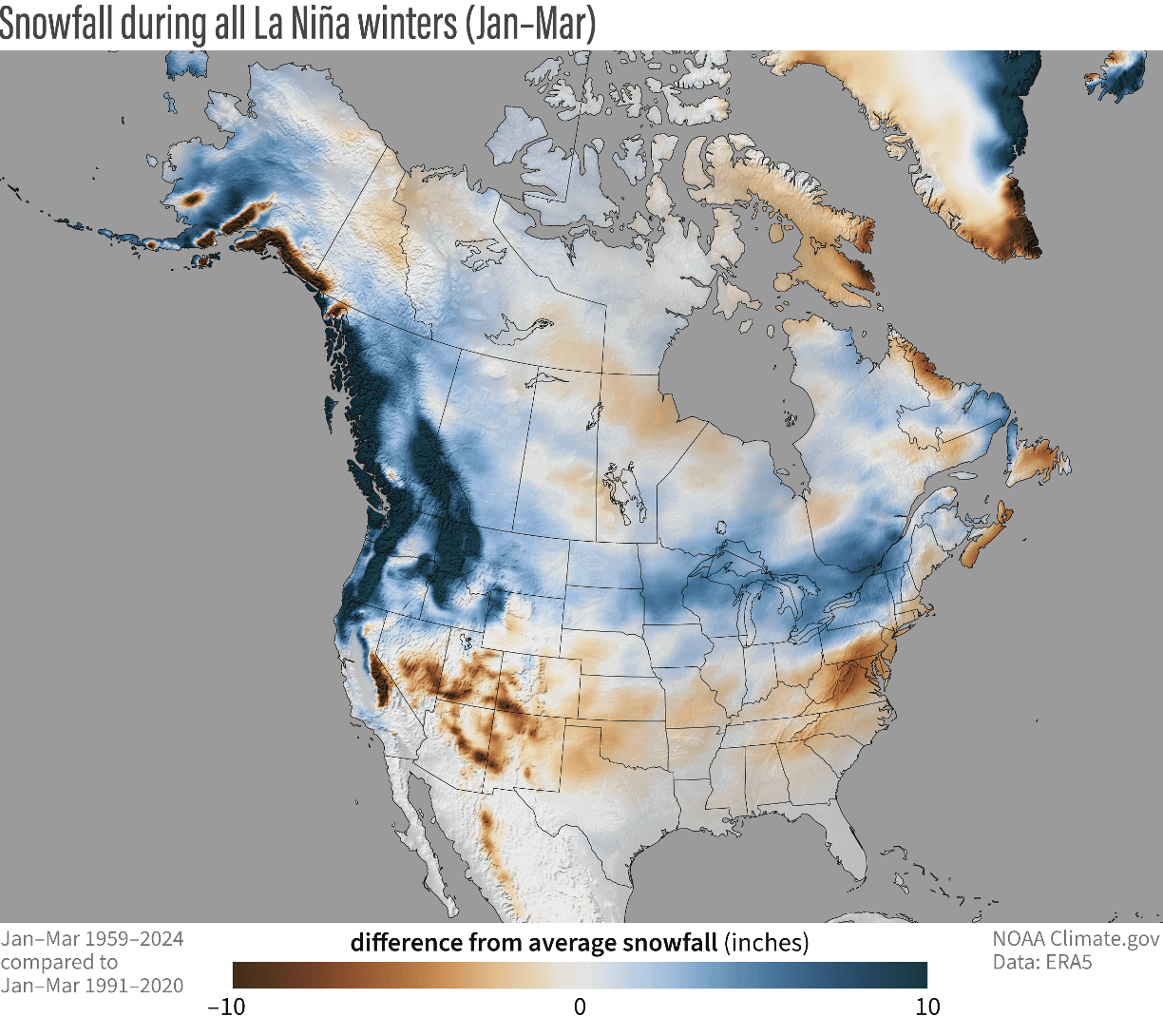
The southern United States usually experiences less snowfall in such winters because the jet stream is more confined to the northern United States and southern Canada.
WINTER STARTS EARLY
Meteorological winter starts on December 1st and lasts until the last day of February. It covers the 3-month period that is statistically the coldest quarter of the year, so all official winter stats are taken in this period.
Below is the pressure anomaly for the first half of December. It shows a broad low-pressure area over the eastern United States and southeastern Canada. Because a low-pressure system spins counter-clockwise, this creates an active cold air transport line directly from the polar regions, called the cross-polar flow. Images by:weathermodels.com

That flow is better seen in the image below, showing the temperature forecast for the same period. You can see the cold air anomaly reaching down into the central and eastern United States and southeastern Canada. The northerly flow on the back side of a low-pressure system fuels this cold air anomaly.
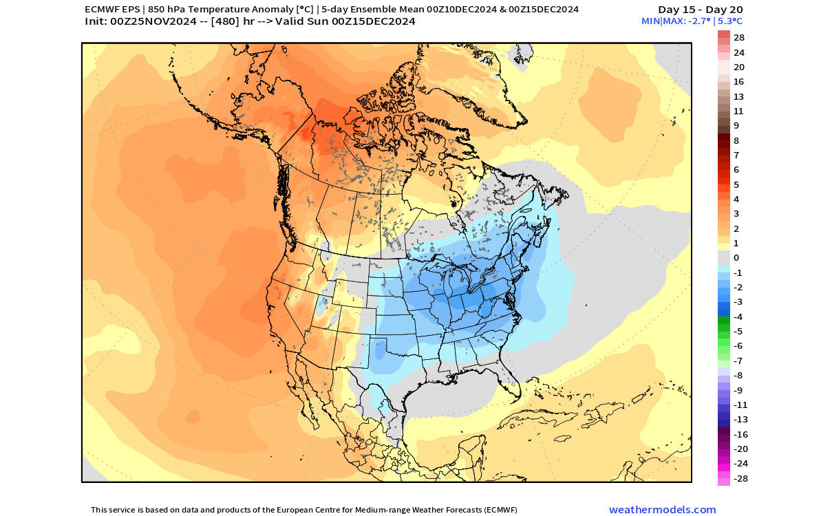
Looking into the second half of December, it is currently forecast to move the main low-pressure area further back north into eastern Canada. But given that a low-pressure system spins counter-clockwise, this will still enable a potential window for cold air to move into the northern and eastern United States.
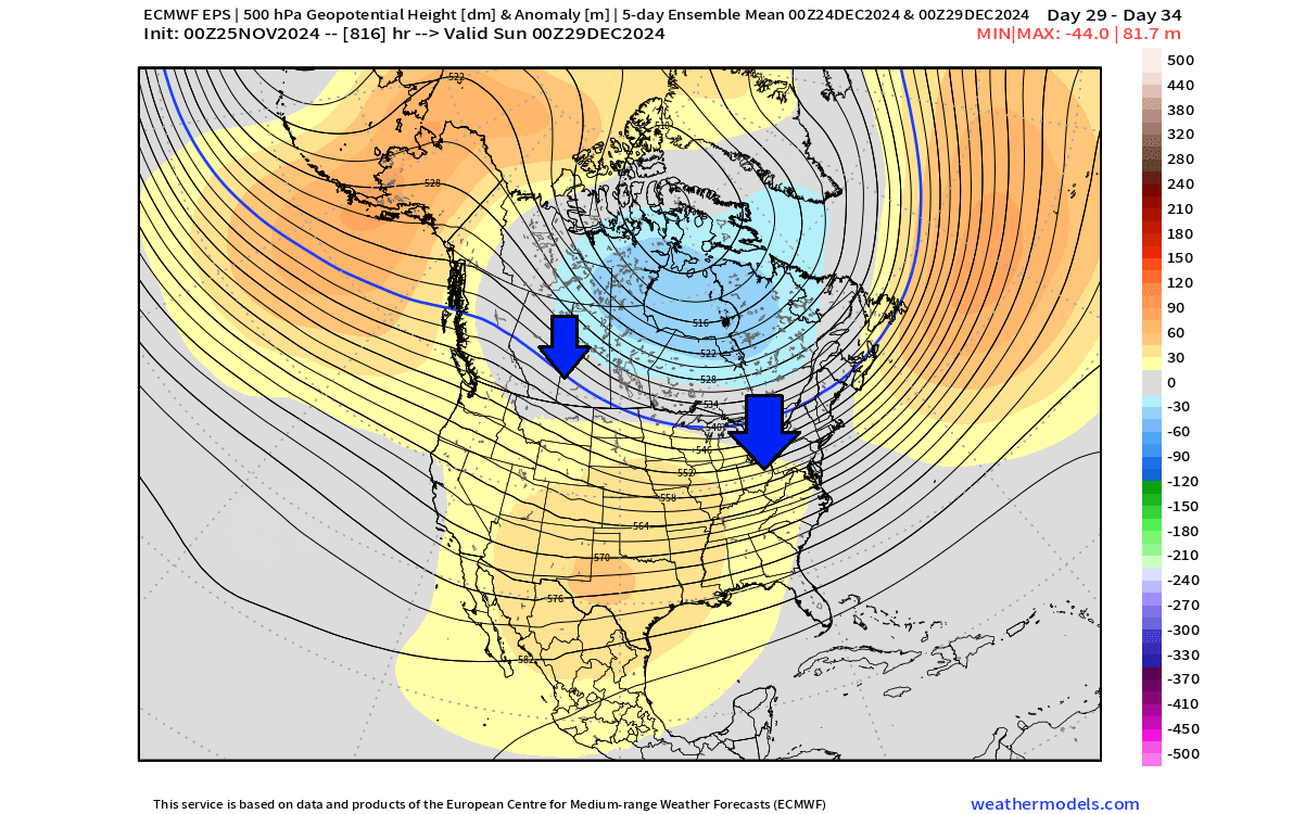
That scenario can be seen on the temperature map, which shows a neutral to cold temperature trend over parts of the Midwest, eastern, and northeastern U.S. With a high-pressure system building out west, temperatures are forecast to rise again over the plains and the southern United States.

Eastern Canada is also forecast to have above-average temperatures in this range. That is because as a low-pressure system spins counter-clockwise, it brings a southern (warmer) flow on its eastern side.
We can also look at the snowfall forecast, but keep in mind that this is a very rough ensemble forecast. It reaches into late December and shows the total snowfall in this period, not snow on the ground. Thanks to the northerly flow, all of Canada and a large part of the United States will experience snowfall at some point in the next month.

So Winter is expected to start off properly, but what can we expect in the long-range?
WINTER 2024/2025 NORTH AMERICA FORECAST
For the Winter forecast, we will look at two seasonal models: the ECMWF and the CFS model from the U.S. NCEP center. All the forecasts are an average picture over three months (January-February-March) and show the general prevailing weather patterns.
Even if the models were 100% accurate, it does not mean such weather conditions would last for three months straight. It only suggests how the weather patterns might look most of the time.
The latest winter pressure pattern forecast from ECMWF shows a high-pressure system in the North Pacific typical of a La Nina. A broad low-pressure area covers eastern Canada and Greenland. A high-pressure anomaly extends from the southern United States into the Atlantic.

Such a pressure pattern pushes the jet stream into the northern and northwestern United States. Due to the circulation, this enables cold air pooling in western Canada and promotes a northerly flow into the northern United States.
The winter temperature forecast shows mostly warmer-than-normal temperatures over eastern Canada, the southern and eastern United States, and the Midwest. But you can see that the warm anomaly gets weaker toward the northern and northeastern United States, which is the likely route to transport colder air from the main source in western Canada.

The latest precipitation anomaly forecast shows an expected La Niña-type pattern over North America. More precipitation is forecast over Canada and the northwestern and northeastern United States. Less precipitation is forecast over the southern United States, especially over the southwest.
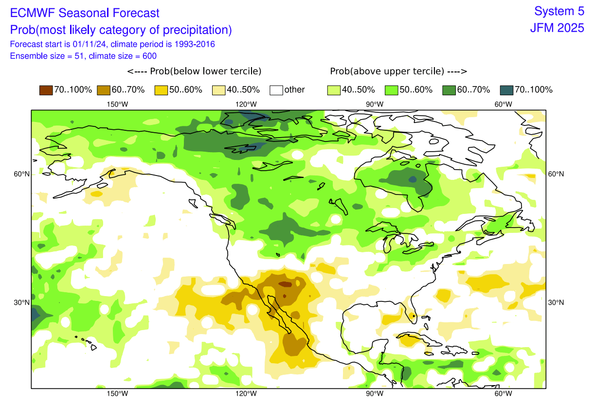
The above images are a 3-month average and can hide some details. That is why we also looked at the monthly data. We found the forecast for January looks promising, as it shows a pressure pattern that supports a northerly flow. That is because of a low-pressure area over Canada, creating a northerly flow just like in December.

Below is a single-month forecast for January 2025, showing less warm anomaly areas over the northern United States. Here, the normal to below-normal area is expanded from the northwestern United States into the central parts and the Midwest.
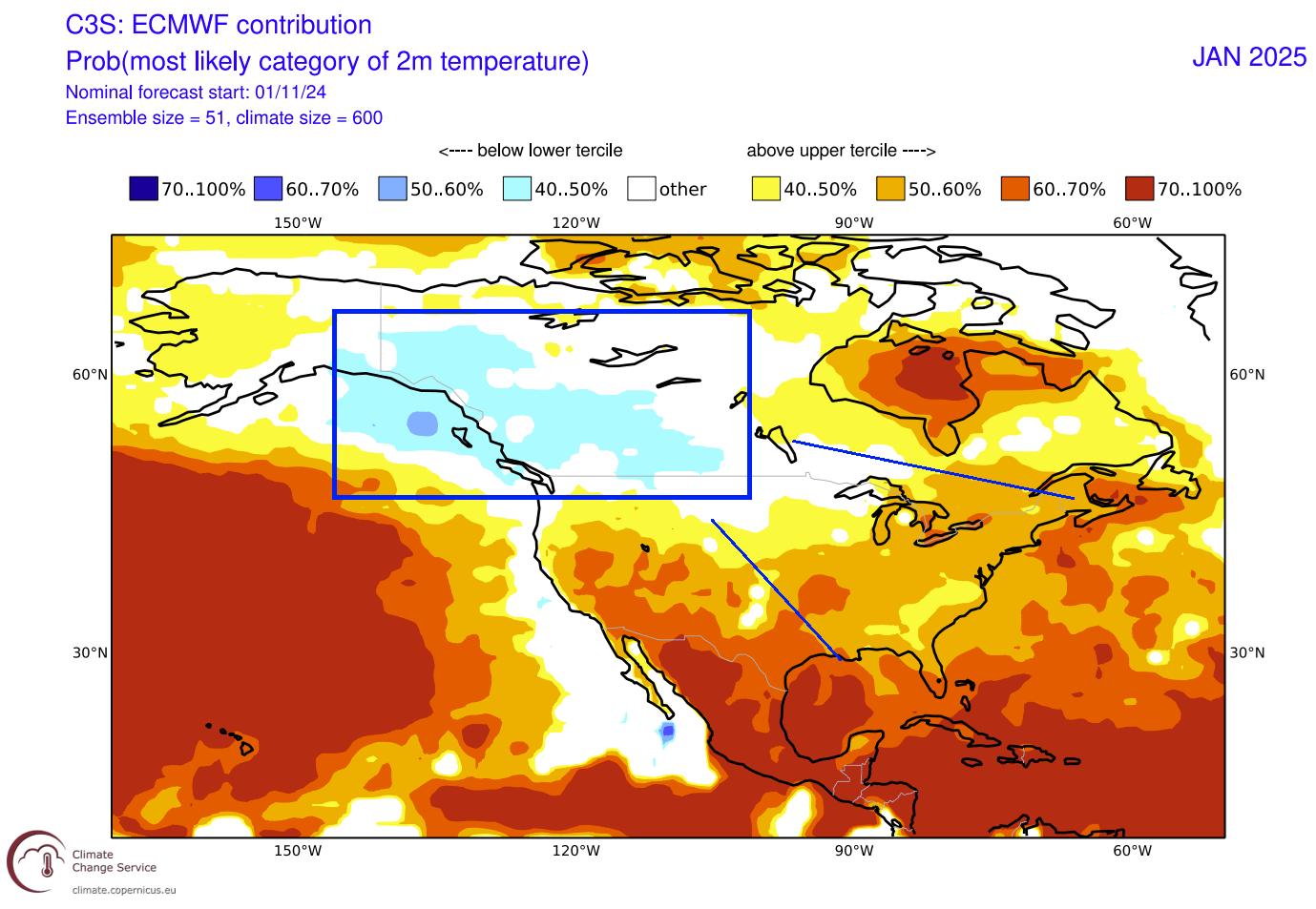
We do not see the cold anomalies extending all the way over the northern United States. But this image tells us that in the monthly average for January, there is likely at least one cold event for the northern, central, and eastern U.S. At least strong enough to reduce the overall monthly temperature forecast average.
WINTER 2024/2025 CFS NORTH AMERICA FORECAST
As you can never trust a single forecast model, we decided to also use the CFS long-range forecasting system. It was developed by the National Center for Environmental Prediction, based in Maryland, U.S.
This forecast shows a La Niña high-pressure system in the North Pacific. It forecasts a low-pressure area over Canada and Greenland, similar to the ECMWF above. This is the typical pattern that enables a northerly flow into western Canada and the northern United States.
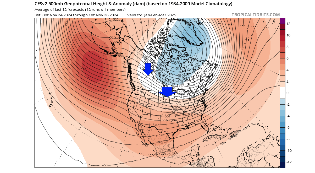
This is a 3-month average, so the weather pattern won’t look like this for 3 months straight. But it does indicate a favorable pattern for some good cold events in the central and eastern United States.
Looking at the temperature forecast, the CFS forecasts above-normal temperatures across the southern half of the United States. But it shows a large cold air pool over Canada, reaching into the northern United States.

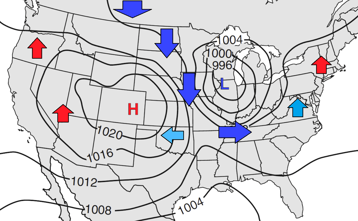
When there is such a large mass of cold air over Canada, that usually means an easier initiation of a cold outbreak even over the northern, central and eastern United States. The cold air is waiting in the north and it just needs a low-pressure system to move over the Great Lakes to create a northerly flow. You can see an example in the image below how that works.
Looking at the monthly images, you can see both the February and March temperature forecasts below. The CFS shows a continued large pool of cold air in Canada and the northern United States, helping to create occasional cold events and snowfall over the central and eastern United States.

Looking at the precipitation forecast over North America, you can see drier-than-normal conditions over the southwestern United States. More precipitation is forecast for the northwestern and eastern United States.

With the cold air over the north, this shows snowfall potential over the Midwest and the eastern United States, with cold air transports form the north.
WINTER 2024/2025 OFFICIAL OUTLOOK FORECAST
Below is the NOAA’s official Winter 2024/2025 temperature forecast for the United States, issued in November. It shows the winter temperature probability, with colder chances in the northern United States. The southwestern part of the country and the east coast have a higher probability of warmer than normal weather.

But take note of the trough of “equal” temperatures extending down low into the Midwest. That can be interpreted as a potential route of winter cold air outbreaks from the north into the east-central United States, as we explained in the examples above.
The official precipitation forecast also shows a classical La Niña pattern. We see an equal-to-high probability of more precipitation (and snowfall) over the northern half of the United States. The southern United States is forecast to have a drier-than-normal winter season.

As usual for a La Niña winter, there can be an issue with the persistence of drought conditions in the south and southwest of the United States.
We will keep you updated on the developing weather trends in the coming seasons, so make sure to bookmark our page. Also, if you have seen this article in the Google App (Discover) feed, click the like button (♥) there to see more of our forecasts and our latest articles on weather and nature in general.
Don’t miss: