The ongoing Winter Storm Bellamy, which blanketed millions from Kansas to Michigan with a foot of snow, is gradually weakening as it moves off the Great Lakes and into Ontario. The next wave to focus on is the rapidly developing Nor’Easter storm mid-week. The pressure falls are forecast to meet the criteria for bombogenesis on Tuesday night.
An additional swath of snow will spread across the Northeast U.S. and Atlantic Canada from Tuesday into Wednesday, with the worst areas across Nova Scotia and Newfoundland. Blizzard conditions and up to 2 feet of snow are expected.
Behind this storm, the coldest air mass blast since February is set to expand across Canada and the Northeast U.S. towards the following weekend and likely to continue into the week after.

On Saturday, an impressive satellite presentation was observed across the United States as Winter Storm Bellamy was impacting the Midwest and the Great Lakes. Locally, more than a foot of snow has accumulated from Iowa to Illinois, impacting millions along the storm’s path.
As shown in the attached satellite image, a warm, moist air mass is being advected from the Gulf of America, while the Arctic cold air mass is spreading behind the storm. This cold clashed with the humid air from the south, resulting in an intense snowstorm.
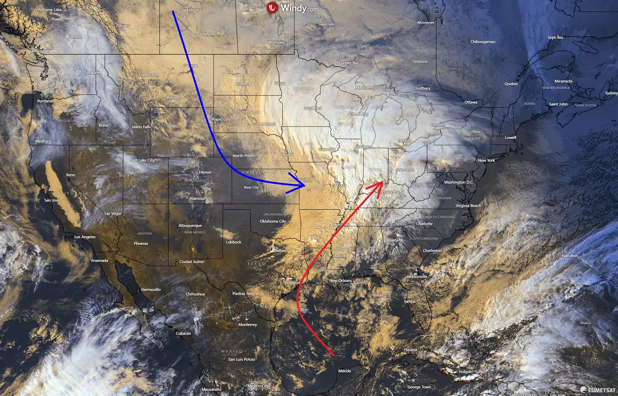
The weather pattern across Canada and the U.S. is now strongly progressive due to the unusually early and substantial disruptions of the Polar Vortex above. This sent several cold waves across the continent, resulting in more rapid, dynamic changes.
The following video represents the changing weather picture across the nation over the next 10 days, with multiple winter storms forecast to deliver more snow and wintry conditions through early December.
The first month of the Meteorological Winter starts with a bang!
Before we discuss the details of the first Nor’Easter storm of the season, we want to consider the primary trigger behind these cold or winter storm events. The intense Arctic blasts and snowstorms often follow a disruption of the Polar Vortex aloft during the winter season.
What is the Polar Vortex?
In simple terms, the Polar Vortex is the broad winter circulation over the northern and southern hemispheres.
The Earth’s atmosphere has six layers. Most of the dynamics of our daily weather occur in the lowest two layers of the atmosphere: the troposphere and the stratosphere. The troposphere is the layer closest to the Earth’s surface. It is about 12 km deep and extends from the ground up high into the sky.
Depending on where you live, its depth varies from around 8 km to almost 20 km. The troposphere is deepest over the equatorial region and becomes much thinner over the North and South poles.
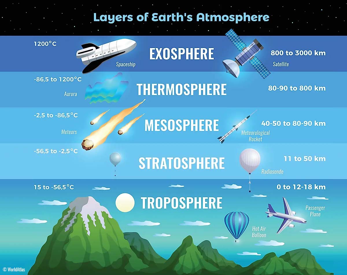
Above this layer is a much deeper one known as the Stratosphere, an 11-50 km thick layer of arid air. Another essential feature in the stratosphere, which makes our weather even more variable, often triggers large-scale, long-lasting winter weather events.
This is the Polar Vortex—an enormous, tri-dimensional ring of powerful winds moving through the sky above us. The Polar Vortex is spinning around the North Pole, grazing through the air at about 20-50 km above the Earth’s surface with violent wind speeds.
The troposphere and stratosphere are crucial for our climate. The Polar Vortex covers most of the bottom half of the atmosphere. Since the vortex extends from the middle of Earth’s troposphere into the stratosphere layer, it significantly affects winter weather across high and mid-latitudes yearly.
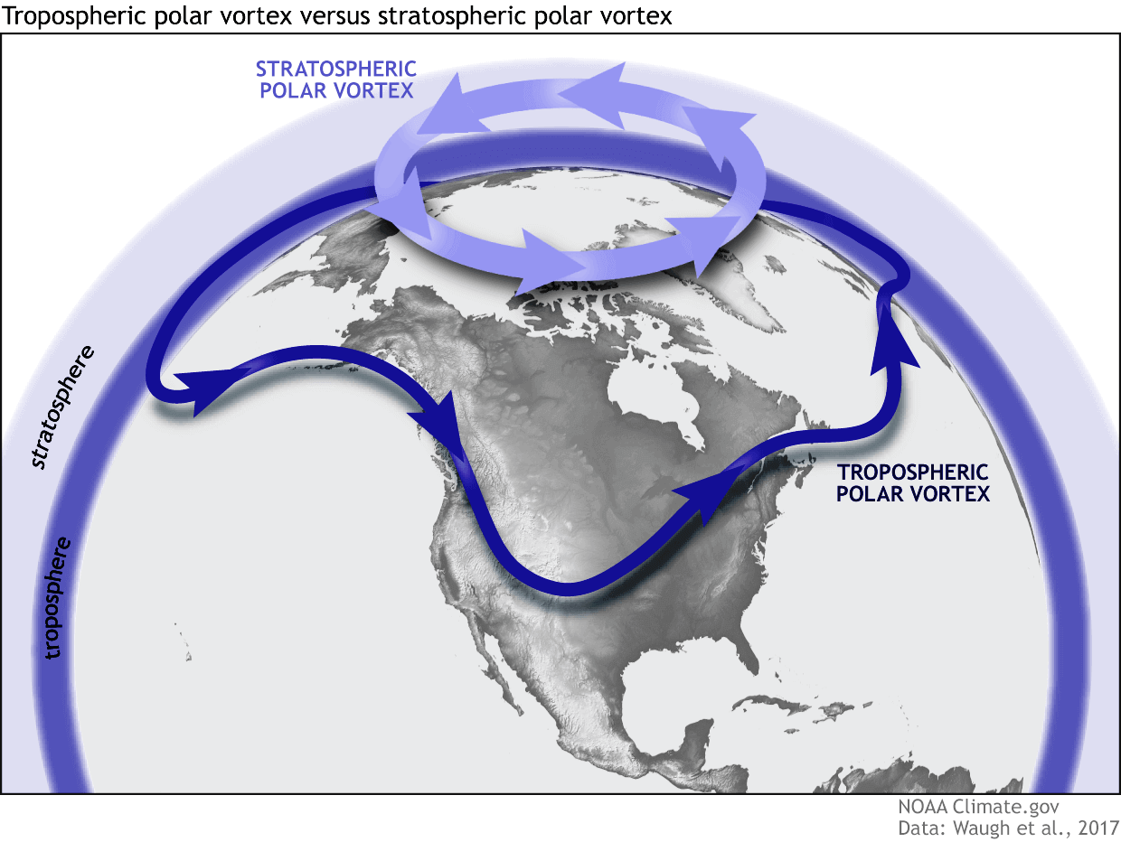
As shown in the image above, we monitor two atmospheric layers during wintertime: the troposphere and the stratosphere. The first is the lowest layer, and the second is at a higher altitude. The Polar Vortex rises through both layers, but with different strengths, shapes, and impacts.
For this reason, we separate the entire Polar Vortex into an upper (stratospheric) and a lower (tropospheric) part. When the Polar Vortex is strong, it traps colder air in the polar regions, preventing its escape and creating milder conditions for most of the United States, Europe, and other mid-latitudes.
Below is an example of how a disrupted Polar Vortex brings cold polar air into the United States and Europe.

But when the Polar Vortex gets disrupted or even entirely collapses, it can’t fully contain the cold air, which can now easily escape from the polar regions into the United States or other mid-latitude regions.
Explosive development of a bomb cyclone along the Atlantic coast Tuesday night
Behind the Winter Storm, a much colder Arctic air mass is spread across the central United States, with a large wave aloft. The wave clashes with the subtropical jet on Monday night and initiates a new disturbance that will lead to rapid development of the secondary wave across the eastern U.S.

Beneath the divergent flow within the jet stream aloft, a surface cyclogenesis takes place along the East Coast on Tuesday, as the wave and cold aloft move farther east, the Arctic air mass clashes with the tropical moisture over the Atlantic.
This leads to a rapid deepening of the surface depression on Tuesday night, meeting the characteristics for bombogenesis. This means the pressure drop exceeds 24 mbar within 24 hours, indicating the development of a bomb cyclone. Therefore, the first significant Nor’Easter storm will be born by Wednesday morning.
The central pressure is forecast to fall from around 1002 to 983 mbar over about 12-15 hours, from Tuesday evening through Wednesday morning, so more rapidly than the bomb cyclone criteria require.
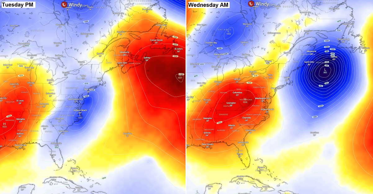
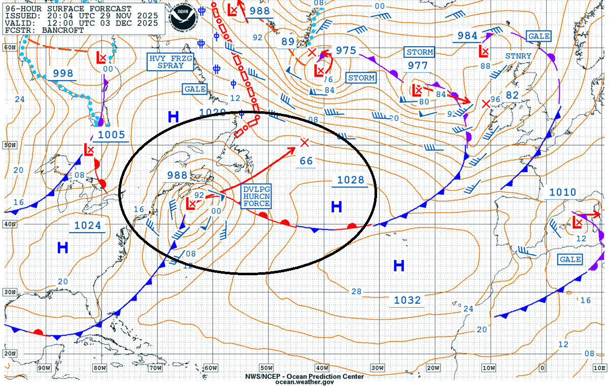
Below is the Ocean Prediction Center (OPC) mid-week outlook, which shows the upcoming intense bombogenesis. The chart also hints at hurricane-force winds developing and spreading towards Newfoundland on Wednesday.
This is a rather typical occurrence when the surface low develops explosively. It could bring violent winds and high waves to coastal areas and, most importantly, combine with heavy snow to create intense blizzard conditions.
The wind field will respond to rapidly changing conditions and a strong pressure gradient between the East Coast and the deep low. Therefore, increase the north-northwest surface winds across the Mid-Atlantic and the Northeast U.S. Tuesday night into Wednesday.
As the low-pressure system develops further on Wednesday morning, the winds will become intense towards Nova Scotia and Newfoundland.
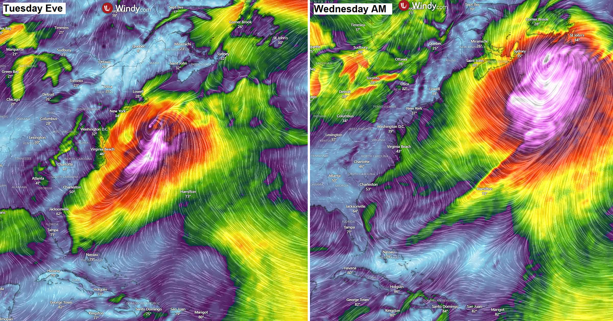
Together with heavy snow, this will lead to complete whiteout and snow blizzard conditions across the region.
Violent snowstorm with intense blizzard across Nova Scotia and Newfoundland on Wednesday
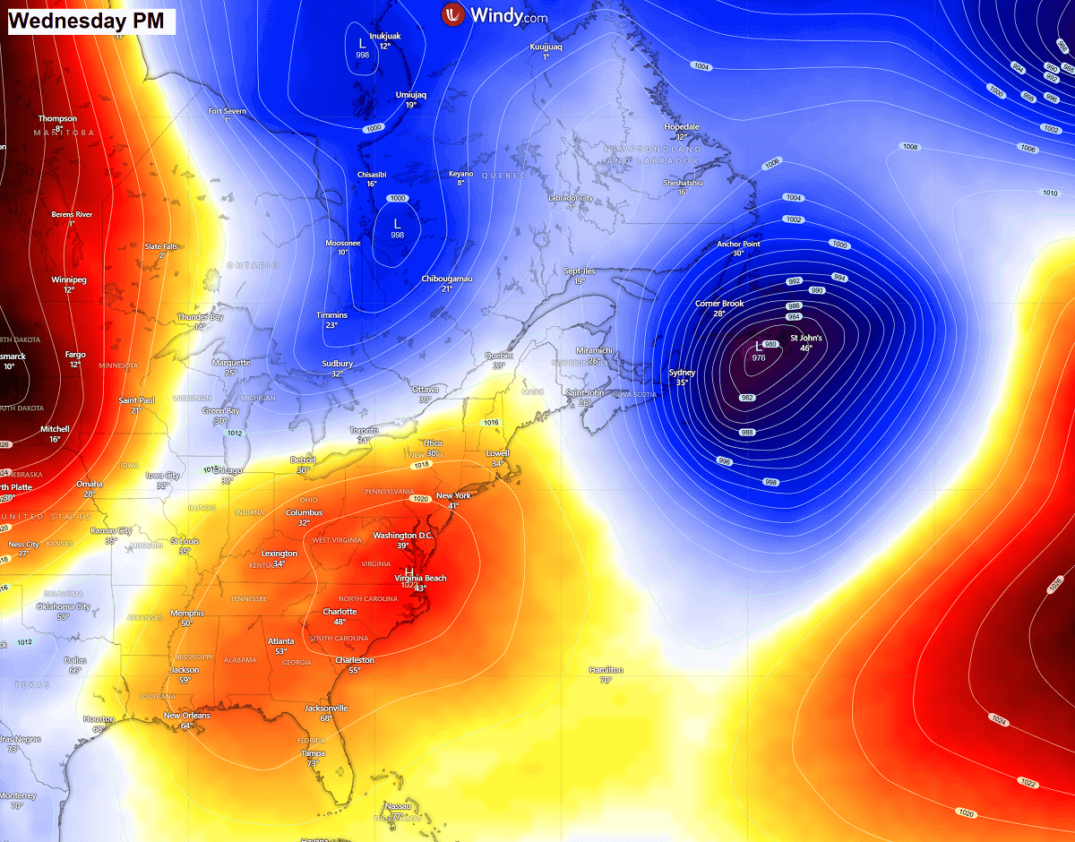
The Nor’Easter will fully mature on Wednesday as it travels south of Nova Scotia towards Newfoundland. The central pressure is forecast to deepen into the mid-970s by the afternoon hours.
This means the pressure gradient across the region will be strong, leading to violent winds and heavy snow. Extreme, blizzard, and whiteout conditions are likely to develop, leading to impassable roads and travel disruptions.
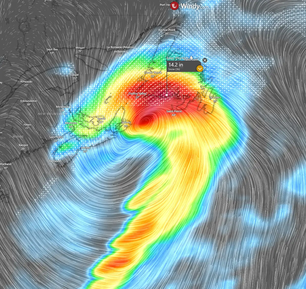
The following chart is a close-up view of Nova Scotia and Newfoundland on Wednesday afternoon, during the powerful bomb cyclone. Wind gusts are forecast to reach 80-90 mph, blasting Newfoundland during intense snowfall.
The wind field will be quite large, as the Nor’Easter grows pretty big on Wednesday. Therefore, strong to severe winds will be spread across a large region.
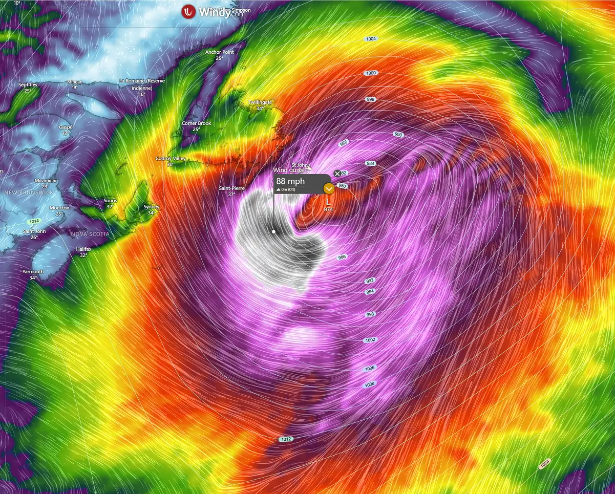
According to some high-resolution weather models, extreme snow, blizzards, whiteouts, and dangerous winter weather are possible across Nova Scotia and Newfoundland during the closest approach of the center low along the coast.
10-15 inches of accumulated snow could result in 3 hours of snowfall at the peak, making the snow intense and locally severe to hurricane-force winds. Roads will be impassable, causing delays and life-threatening conditions if trapped outside.
Severe winds, heavy snow will also combine with low windchill as temperatures plummet further as soon as the low passes east, dragging a much colder air mass from the interior lands.
The following chart indicates the potential swath of the accumulated snow along the path of the Nor’Easter bomb cyclone from late Tuesday through Thursday morning. Snow accumulation begins in the Appalachians and extends across the Northeast U.S. into Maine and New Brunswick, with deep snow expected.
Further northeast, across Nova Scotia and Newfoundland, much higher snowfall intensity is forecast, leading to 2-3 feet of snow where the heavy snow swath will be maximized. Combined with violent winds and blizzard conditions, impassable snow drifts are expected as well.

While the exact path of the bomb cyclone is hard to predict, most weather models show strong agreement on a significant impact across the Northeast U.S., especially in Atlantic Canada.
The coldest air mass since February will spread across Canada and the Northeast U.S.
Following major Polar Vortex disruptions, intense cold outbreaks are spreading across North America as we head into early December. Following the mid-week bomb cyclone, a deep wave emerges into the Northeast U.S.

This will allow frigid Arctic air masses to spread frigid temperatures across central and eastern Canada, into the Great Lakes, and towards the Great Lakes, Mid-Atlantic, and Northeast U.S. by next weekend, delivering brutal cold.
Temperatures are forecast to plunge 30 °F below normal in early December, with temperatures remaining well below freezing for multiple days.
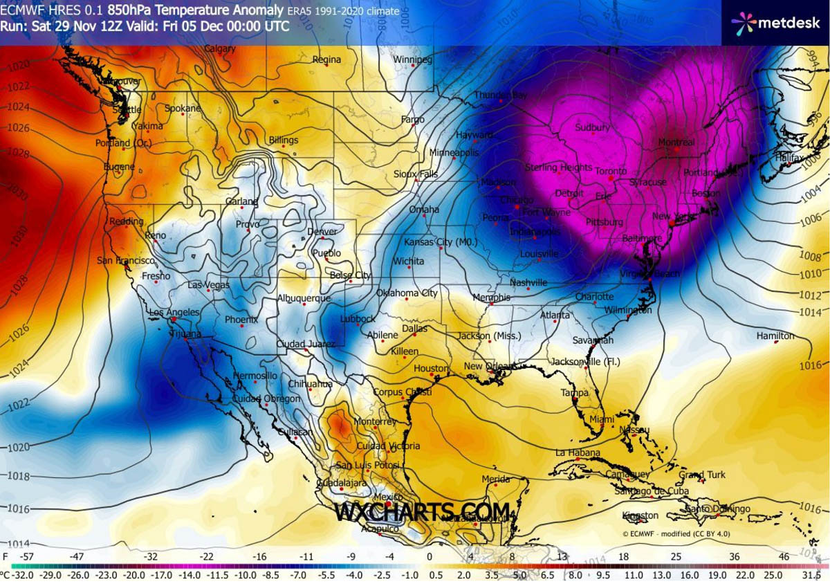
We continue to closely monitor the evolution of the progressive patterns across the US and Canada as December starts. Following the unusually early and significant disruption of the Polar Vortex aloft this winter, conditions are prone to rapid changes in the coming weeks.
Stay tuned for further updates in the coming days as new winter storms and Arctic cold outbreaks follow.
Windy, TropicalTidbits, and Wxcharts provided images used in this article.
See also:
Winter Storm Bellamy impacts across the Midwest and the Great Lakes