A massive Polar Vortex disruption digs deep into the heart of the United States this Friday, triggering a Winter Storm Fern. More than 150 million will be in the storm’s path from Texas to the Mid-Atlantic over the weekend.
Beginning Friday and surging through the weekend, Winter Storm Fern is expected to unleash a significant mix of heavy snow, freezing rain, sleet, and damaging ice storm.
Key Messages:
The Ice Storm corridor: A swath of dangerous freezing rain, sleet, and black ice is forecast from North Texas through the Carolinas. Freezing rain could accumulate up to 2 inches in places, a weight capable of snapping power lines and paralyzing infrastructure, leading to widespread road closures and major travel disruptions.
The Snow Bomb: Portions of North Texas, Oklahoma, the mid-Mississippi and Tennessee valleys, the Mid-Atlantic, and the Northeast are bracing for a foot of snow as the clash of the Polar front and the subtropical airmass from the Gulf will be intense, with high moisture feeding a powerful Winter Storm.
Brutal Cold: From Canada into the Midwest and the Great Lakes, a season’s record-breaking frigid Arctic cold air will turn wet roads into treacherous black ice, creating significant travel conditions that could last for days. Extreme Cold with winds will result in windchill temperatures near -50 degrees.
Expect widespread power outages and significant travel disruptions to ripple across two dozen states, affecting more than 150 million people from Friday through Sunday. Prepare now. Whether you are in Dallas, Little Rock, Atlanta, or Washington, D.C., the window for preparation is closing as Winter Storm Fern is expected to rapidly form early Friday.
Some highways and local roads may become impassable for several days across North Texas and Oklahoma, as well as heavily populated areas of Georgia, the Carolinas, and Virginia.
Before we dig into the details of the Winter Storm impact, it is essential to understand the background mechanisms governing the Polar Vortex. It is the main trigger for rapid weather changes and intense Arctic outbreaks across Canada and the United States during winter.
What is the Polar Vortex?
The Earth’s atmosphere has six layers. Most of the dynamics of our daily weather occur in the lowest two layers, the troposphere and the stratosphere.
The troposphere is the layer closest to the Earth’s surface. It is about 12 km deep and extends from the ground up high into the sky. Depending on where you live, its depth varies from around 8 km to almost 20 km. The troposphere is deepest over the equatorial region and becomes much thinner over the North and South poles.
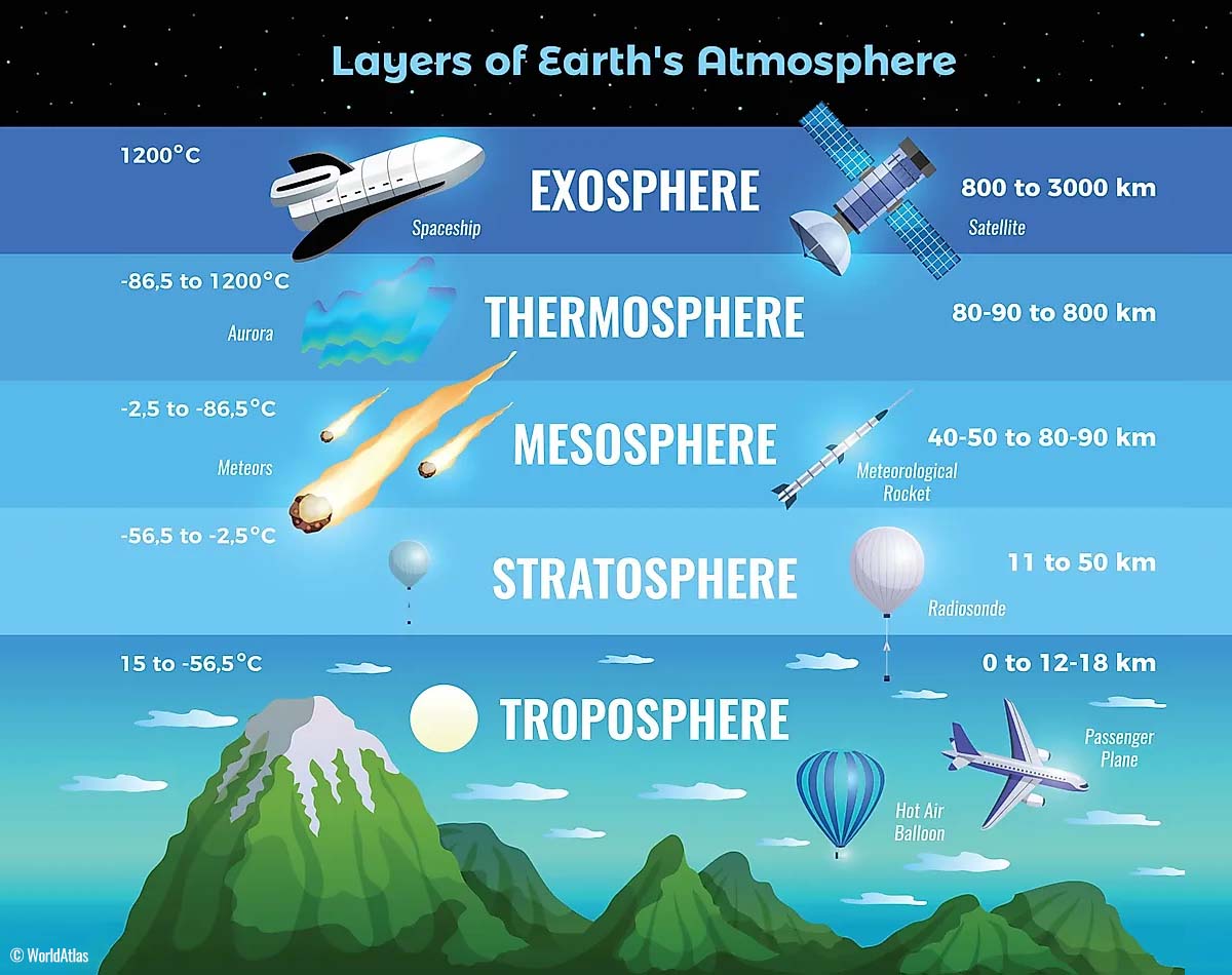
Above this layer is a much deeper one known as the Stratosphere, an 11-50 km thick layer of arid air. Another essential feature in the stratosphere, which makes our weather even more variable, often triggers significant, large-scale, long-lasting winter weather events.
This is the Polar Vortex—an enormous, tri-dimensional ring of powerful winds moving through the sky above us. The Polar Vortex is spinning around the North Pole, grazing through the air at about 20-50 km above the Earth’s surface with violent wind speeds.
How and when does the Polar Vortex form?
Due to the Earth’s inclination, the polar regions receive much less energy from the Sun during the fall months. This makes the cooling over the northern areas more robust. As a result, polar nights can last several consecutive months, followed by days without sunlight.
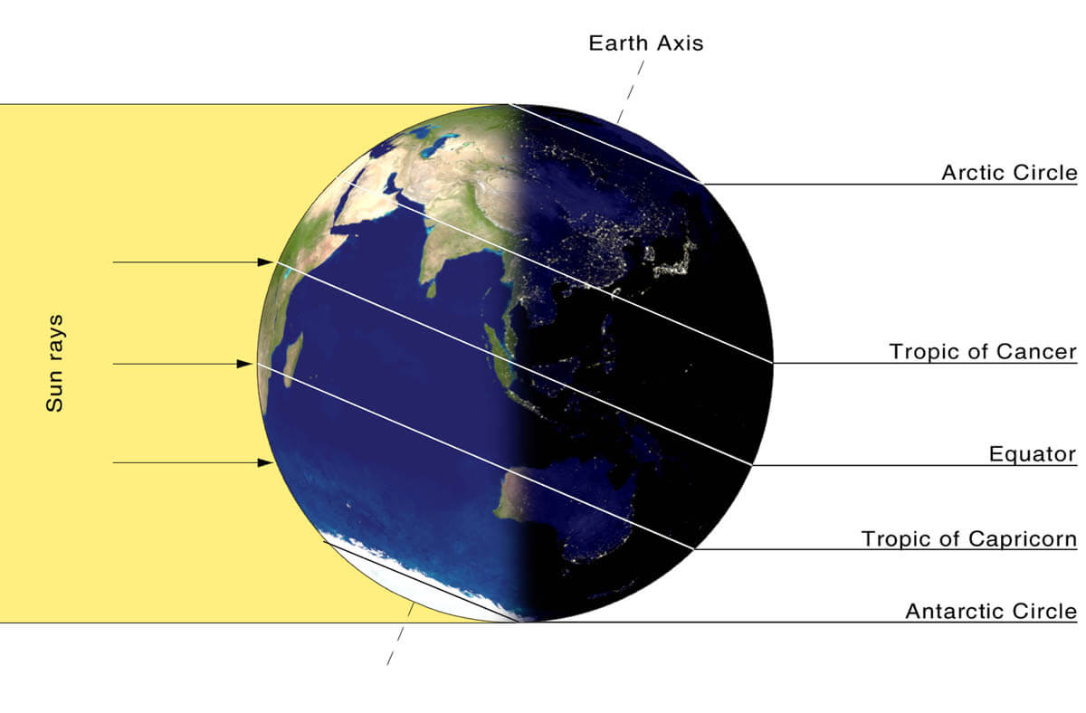
While temperatures in the polar regions are dropping into a deep freeze, the atmospheric layers farther to the south are still relatively warm because they receive more of the Sun’s energy at the same time. Therefore, the south’s equatorial layers remain much warmer than the areas farther north, leading to a high-temperature contrast.
Cooling the polar regions also lowers the ambient surface pressure, and a similar weather process occurs in the stratosphere. The temperature difference between the North Pole and the equatorial areas increases across both layers.
This creates a large, low-pressure cyclonic circulation across the polar stratosphere, which gives it its famous name—the Polar Vortex.
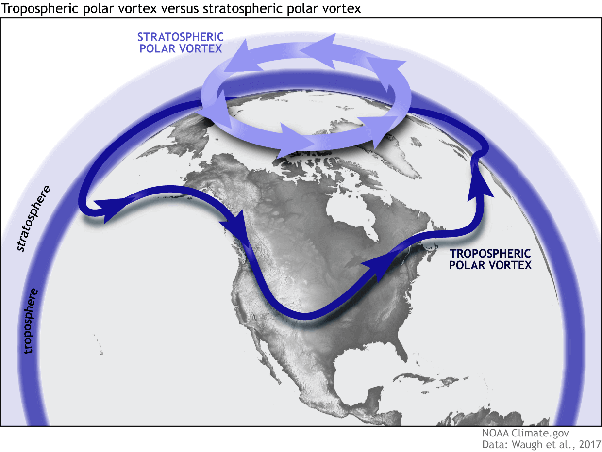
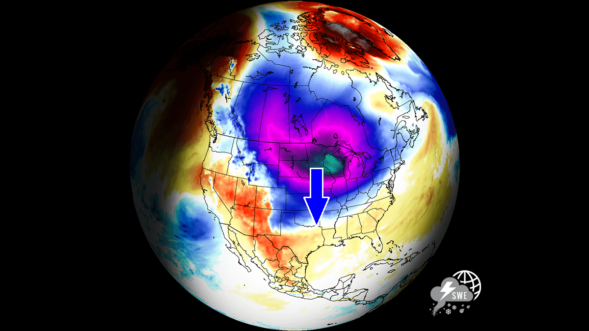
As shown in the image above, we monitor two atmospheric layers during wintertime: the troposphere and the stratosphere. The first is the lowest layer, and the second is at a higher altitude. The Polar Vortex rises through both layers, but with different strengths, shapes, and impacts.
For this reason, we separate the entire Polar Vortex into an upper (stratospheric) and a lower (tropospheric) part. When the Polar Vortex is strong, it traps colder air in the polar regions, preventing its escape and creating milder conditions for most of the United States, Europe, and other mid-latitudes.
But when the Polar Vortex gets disrupted or even entirely collapses, it can’t fully contain the cold air, which can now easily escape from the polar regions into the United States or other mid-latitude regions. Below is an example of how a disrupted Polar Vortex brings cold polar air into the United States and Europe.
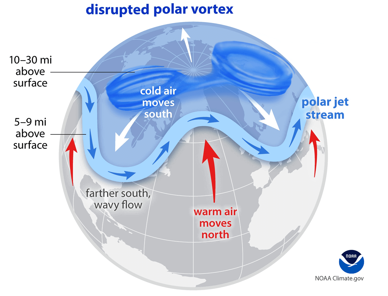
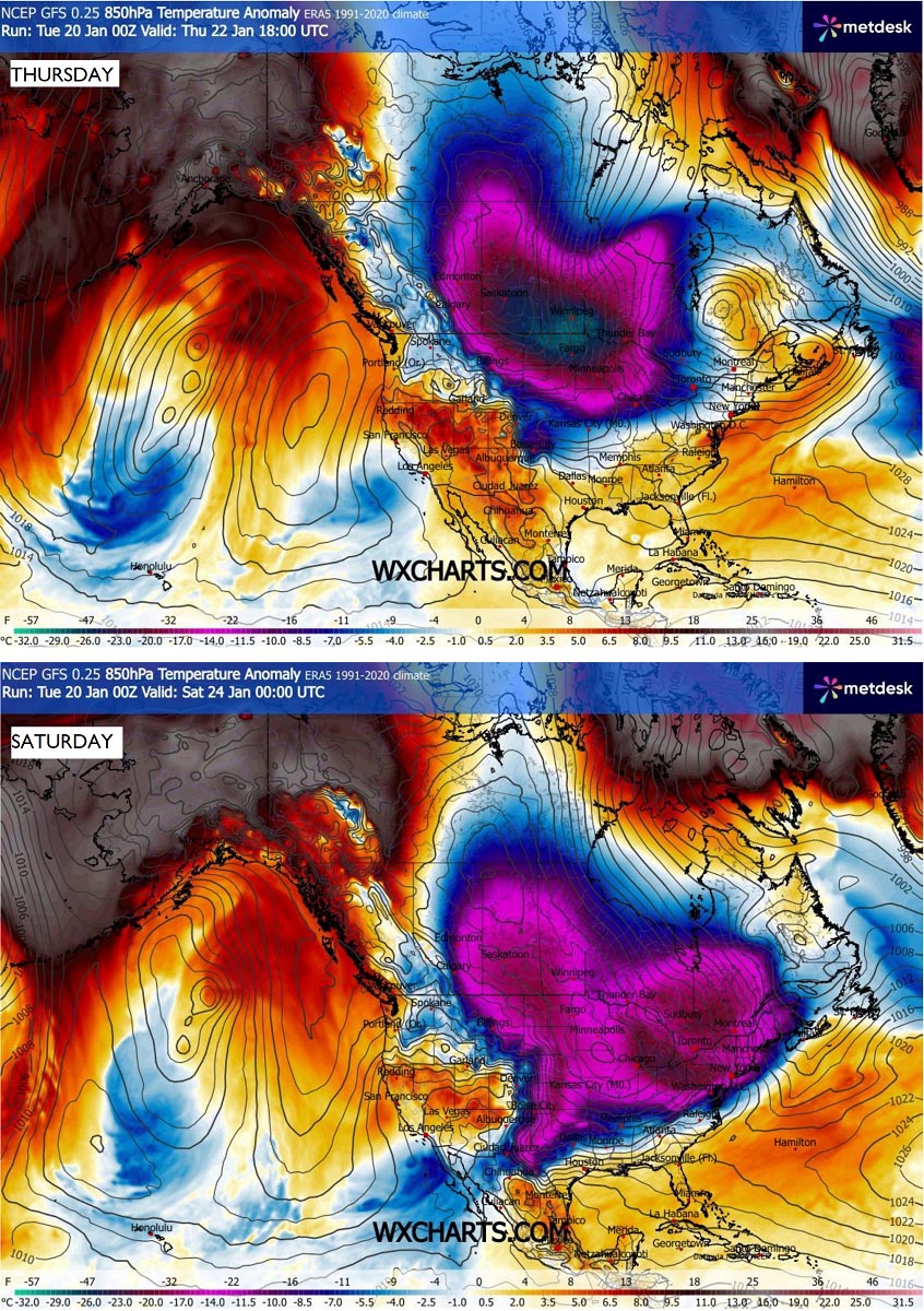
We have experienced this in Asia, Canada, the U.S., and sometimes Europe in recent years. The vortex aloft has been significantly disrupted this season, and when its lobe shifts away from the North Pole, the extreme cold grips the North American continent.
Polar air mass clashes with warmer south: Triggers an impactful Winter Storm Fren with deep snow, freezing rain, and ice
The weather pattern over North America remains similar through this week, presenting a picture-perfect position of the Highs and Lows over the North Pacific and North American continent.
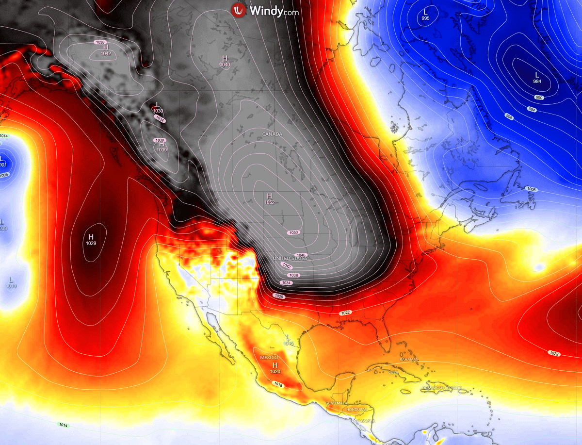
A powerful Omega blocking High is parked over the Pacific Northwest, with a deep Polar Low digging far south from Arctic Canada into the United States.
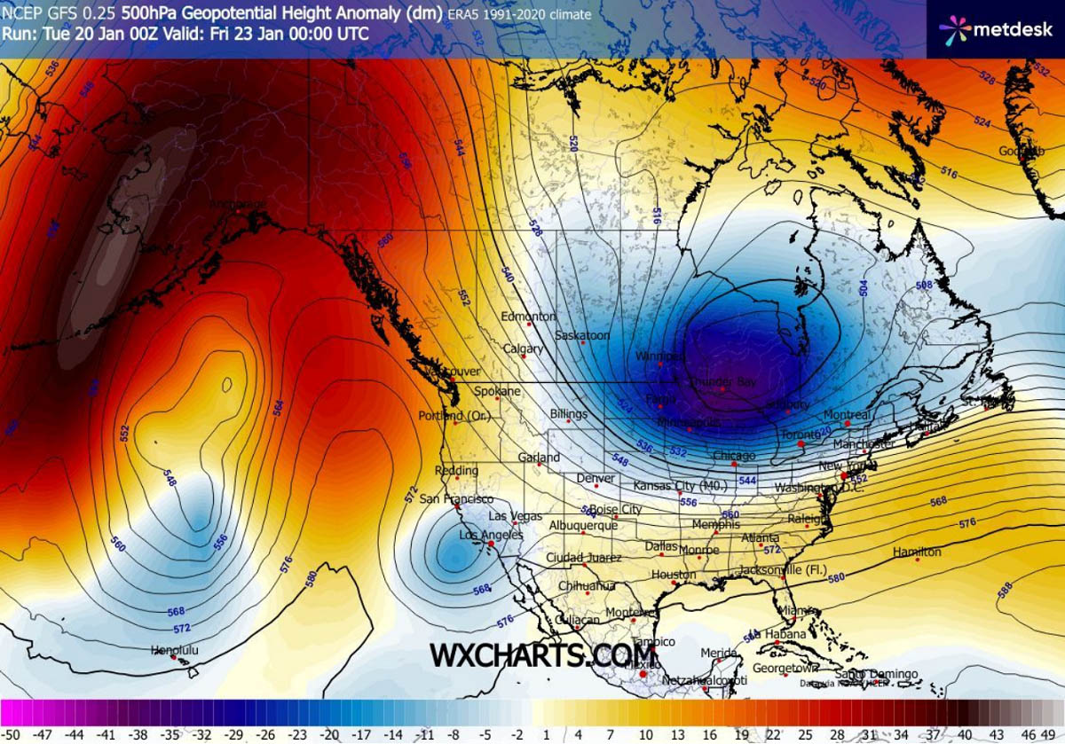
This is a scenario in which significant cold advection follows into the lowlands, as the Polar Vortex circulation is undergoing a significant disruption, sending its southern lobe aloft deep into the southern hemisphere. It brings powerful cold waves into the mid-latitudes.
The Polar air mass also results in a major rise in surface high pressure, with a broad 1040-1050 mbar blocking high dominating most of Canada and the US this week into the following weekend.
By midday Friday, snow begins in the southern High Plains as the rapidly developing Winter Storm Fern intensifies. Surging through the weekend, the storm is expected to unleash a significant mix of heavy snow, freezing rain, sleet, and damaging ice storm along its path.
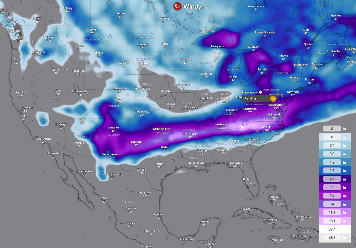
A swath of deep snow will blanket millions from North Texas and Oklahoma, to the mid-Mississippi and Tennessee valley, the Mid-Atlantic, and the Northeast. Around a foot of snow, or nearly 2 feet, will be possible where the clash of the Polar front and the subtropical airmass from the Gulf will be the most intense.
South of the snow bomb, a narrow corridor of dangerous weather will form. A strong warm advection in the midlevels while the polar air mass grazes south at the surface. This results in a major ice storm from East Texas across the southern States to Georgia.
Some areas along this broad swath of freezing rain, sleet, and ice storm could receive 1-2 inches of black ice. Which would become a major damaging event with significant tree damage, widespread power outages, major travel disruptions, and impassable roads.
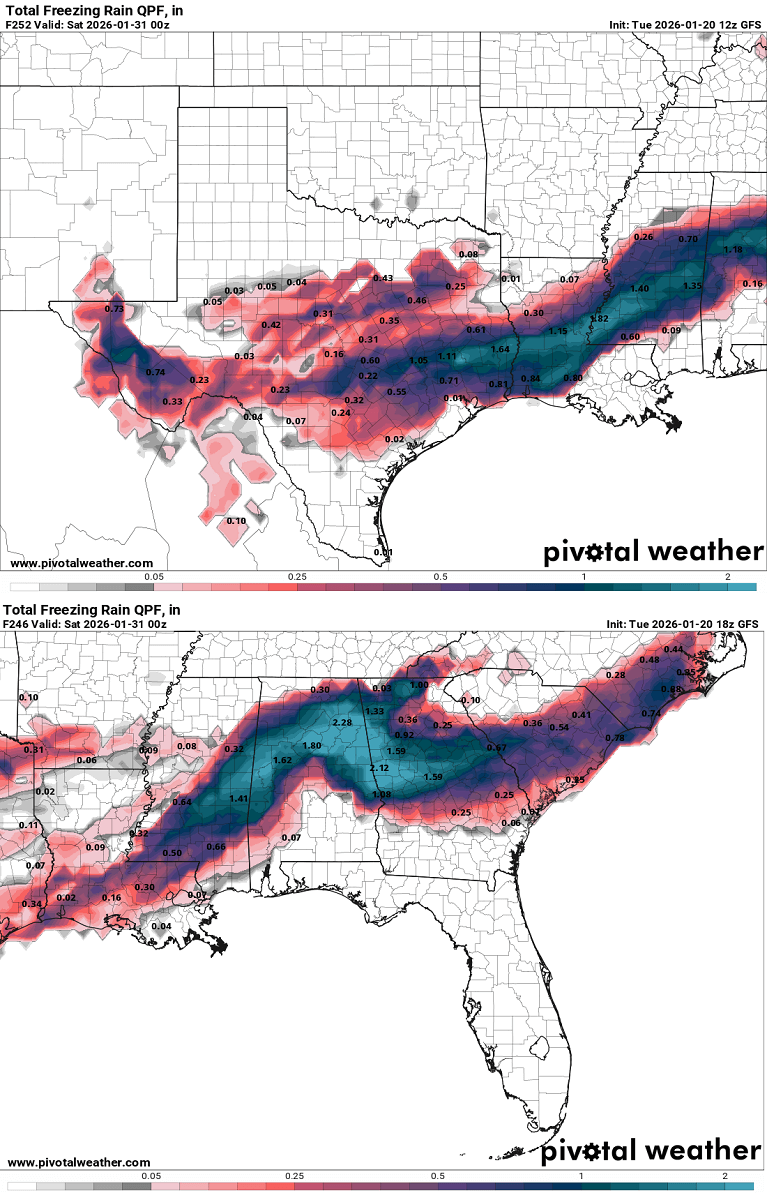
Where exactly the heaviest freezing rain and heavy snow will develop is hard to predict, as conditions supporting freezing rain could shift north-south by 50 miles and affect areas further south, as currently anticipated by the latest model guidance.
How does Sleet and Freezing Rain form?
The freezing rain forms when a layer of warm air aloft is placed above a layer of below-freezing (subfreezing) air at the surface. Snowflakes that are falling towards the ground melt as they fall through this warm layer.
If the flakes are completely melted, they fall as rain towards the ground, which is much colder. This liquid droplet then freezes on contact with exposed surfaces.
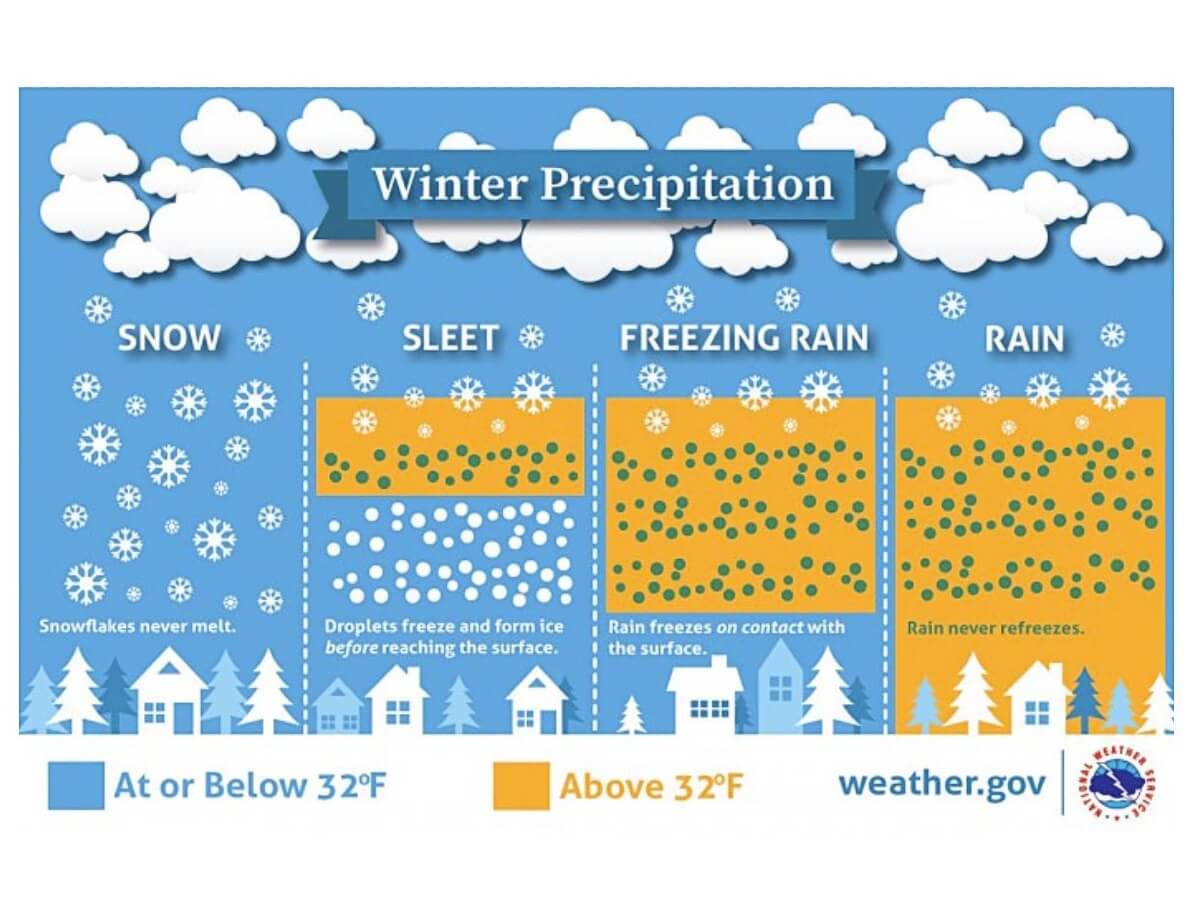
Sleet or ice pellets are a form of precipitation consisting of small, translucent balls of ice. Ice pellets are smaller than hailstones and are different from graupel.
Ice pellets often bounce when they hit the ground or other solid objects (e.g., jackets, windshields, and dried leaves). They generally do not freeze into a solid mass unless mixed with freezing rain.
The precipitation forecast chart hints at where the highest amounts are likely to be expected. From East Texas across the Lower Mississippi across the Southeast U.S. to the East Coast.
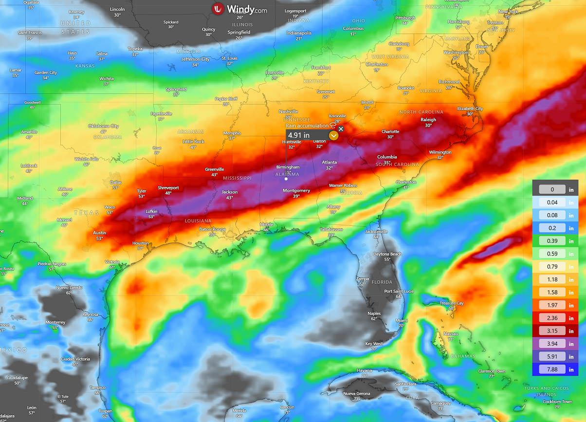
Around 3-5 inches can be expected. The wintry mix with deep from the north, to freezing rain and sleet in the middle, to heavy rain with thunderstorms further south. A dynamic storm to say at least.
Polar Vortex shifts deep south across North America, drags season’s coldest Arctic outbreak
With the deep core of the Polar Vortex southern lobe aloft, the season’s most significant Arctic air mass intrusion will follow across the United States, rapidly spreading south from late Thursday into Friday. Reaching the Gulf Coast through Saturday midday behind the Winter Storm Fern.
The core will be particularly intense and frigid, with temperatures 40-50 °F below normal for late January. It grazes south across Central Canada Wednesday night and rapidly advances behind the Polar Front Thursday into Friday, reaching the Texas coast Saturday morning.
The Cold will continue east-southeast behind the frontal system over the weekend, bringing frigid low temperatures into the Mid-Atlantic and the Southeast U.S. Temperatures finally warm up over Alaska under the strong ridge.
There’s nothing to stop the extreme cold from reaching the Gulf Coast, so expect temperatures in Texas to be 50 °F below average by Saturday.
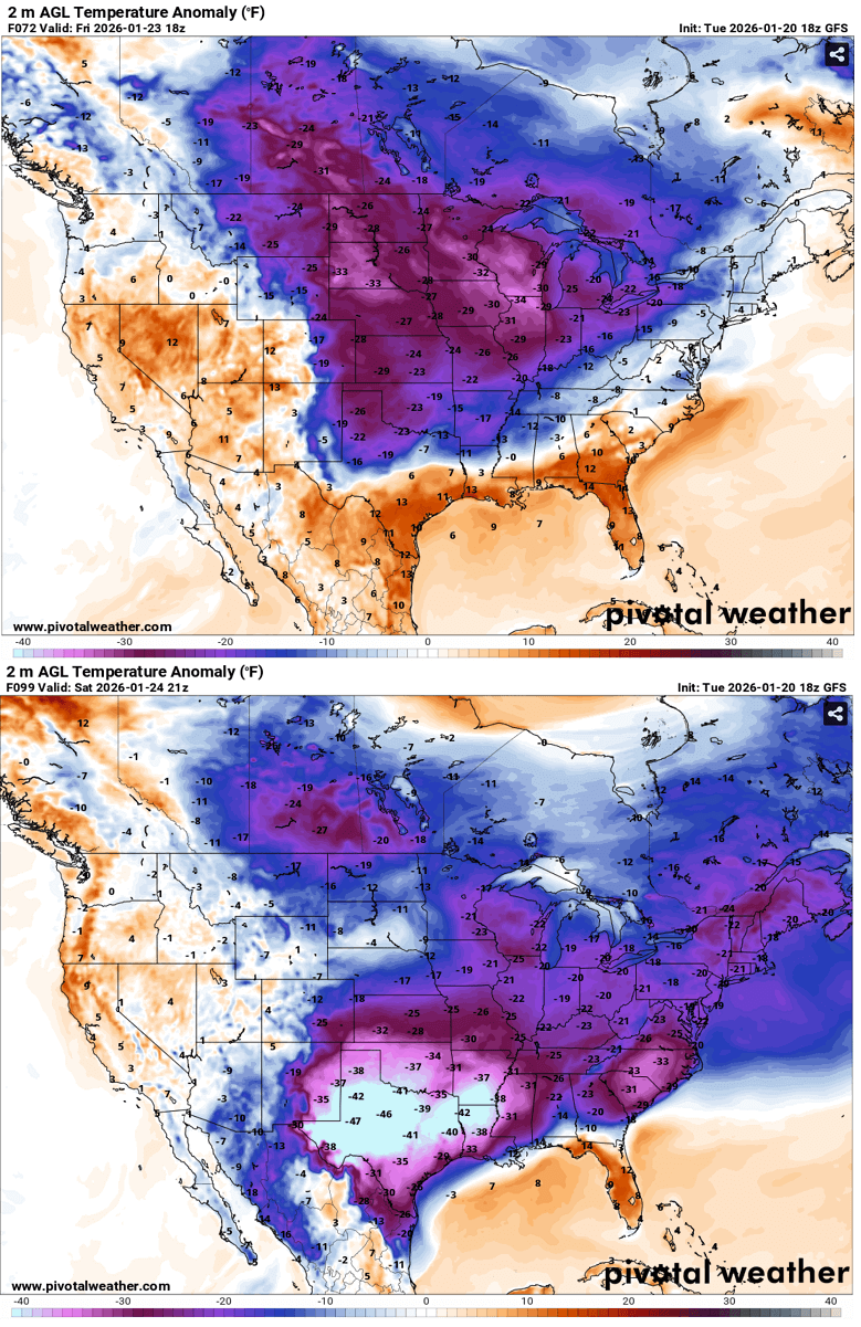
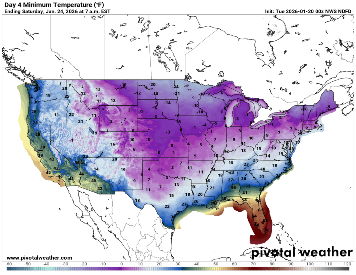
Both Friday and Saturday will deliver frigid cold across the northern U.S., with morning lows near -25 °F across the Dakotas and the Upper Midwest. Single digits across the Great Lakes, Midwest, and High Plains to the mid-Mississippi Valley.
A significant cold outbreak will also bring very low morning temperatures to Texas, with single digits in the north and low- to mid-20s across the West and south Texas. Also, below freezing along the Gulf Coast from Corpus Cristi to Houston and southern Louisiana on Saturday morning.
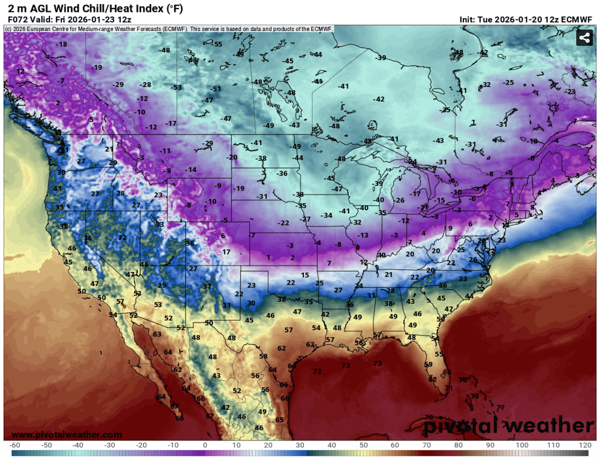
With strong winds behind the Polar front, extremely low windchill temperatures are forecast. Those will be in the -30 to -50 range across the northern half of the U.S. into Canada, with local areas close to -60 °F low windhills possible on Friday and Saturday.
A frigid cold air mass with dangerously low wind chill will also develop across the Midwest, the Great Lakes, and the Ohio Valley. Resulting in more lake-effect snow around the Lakes.
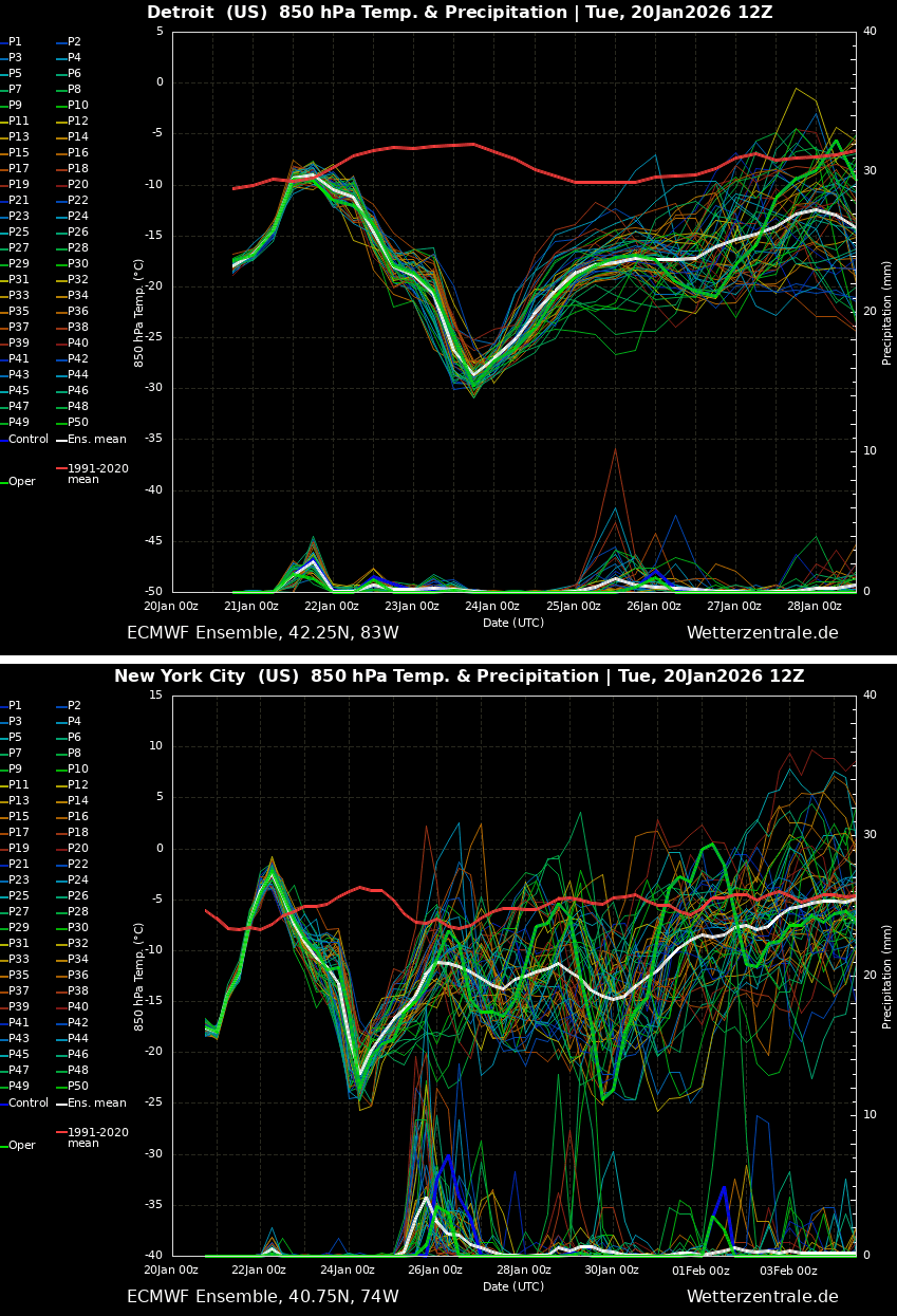
How intense the Polar outbreak is in delivering the season’s record lows is well visible on the meteogram charts; the comparison is for Detroit and New York City.
Air masses rapidly flip into much colder temperatures than it has been experiencing recently, with a 30-40 °F drop within a 24-hour period from Thursday into Friday.
Mid-term weather models hint at the gradual vanishing of the Arctic cold pool after the following weekend, possibly bringing the normal temperatures back for many next week. We will continue monitoring the patterns and update accordingly.