The snowstorm is expected to have a significant impact on major cities, including St. Louis, Chicago, and Detroit, with travel disruption expected. Heavy snow, ice, and local blowing snow are expected, with near-blizzard conditions. Winter Storm Bellamy will have a significant impact on airline traffic after the Thanksgiving holidays. Travellers should anticipate delays and flight cancellations.
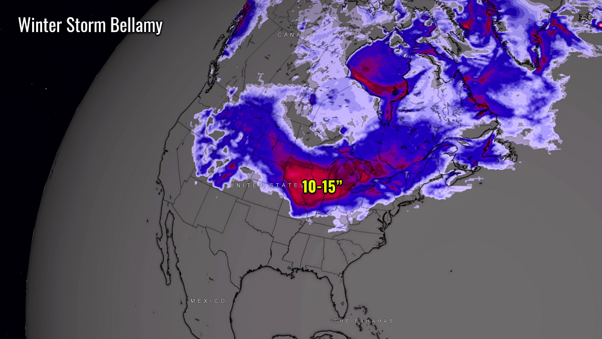
By Saturday evening, moderate to heavy snow is forecast across a more than 1,000-mile-long swath from Colorado to east of Detroit.
Around a foot of snow (8-12 inches accumulation) is forecast to blanket a broad swath from southeastern South Dakota and Iowa across Illinois, Minnesota, through Michigan, and into parts of Ontario this weekend.
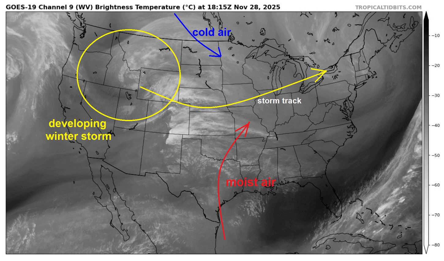
On Friday, the satellite picture across the North America revealed how the weather pattern is shaping up, with developing a Winter Storm Bellamy across the northern Rockies as a deep wave emerges from the Pacific Northwest.
As the wave travels east, a surface low forms and drags the moist air mass from the south into the Midwest. While from Canada, an Arctic cold blast follows. Resulting in a major snowstorm on Saturday, travelling towards the Great Lakes.
The following video reveals the progress of this Arctic outbreak over the next 7-10 days. We can see how progressive the weather will be over North America, with multiple deep waves travelling across the CONUS and Canada.
Expect the weather to remain dynamic, with conditions ranging from extreme cold to brief mild periods through the first half of December 2025. Overall, the conditions are more likely to favor wintry weather.
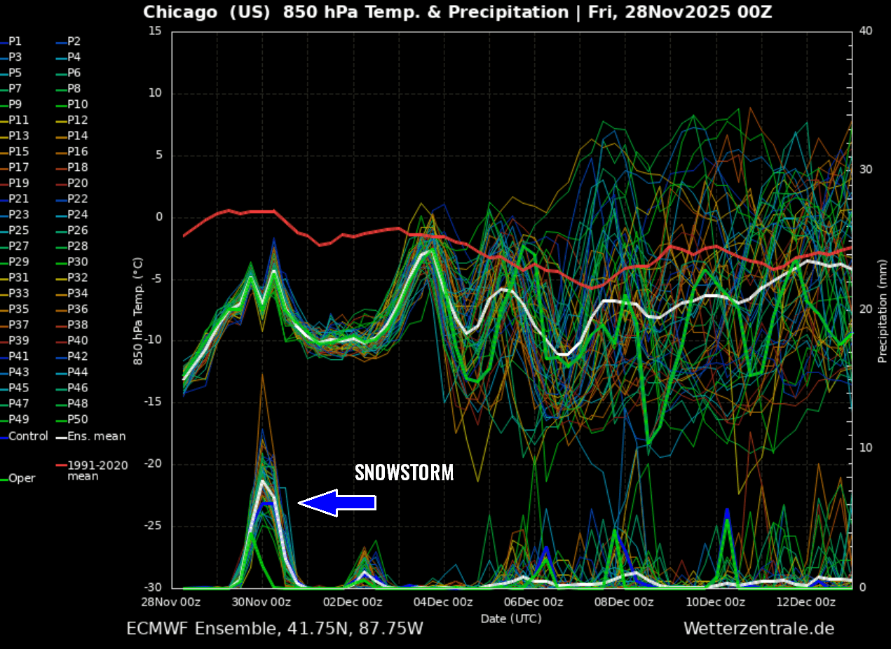
A brief look at the 14-day meteogram for Chicago shows the weather pattern will be pretty dynamic through early December. The Saturday’s Winter Storm with a major snowstorm is well seen on the precipitation chart.
Judging from the temperature chart, we can expect multiple cold waves over the next two weeks. Several winter storms and cold blasts are predicted.
Before we discuss the details of the upcoming snowstorm event, we want to consider the primary trigger behind these cold or winter storm events. The intense Arctic blasts often follow a substantial disruption of the Polar Vortex aloft during the winter season.
What is the Polar Vortex?
In simple terms, the Polar Vortex is the broad winter circulation over the northern and southern hemispheres.
The Earth’s atmosphere has six layers. Most of the dynamics of our daily weather occur in the lowest two layers of the atmosphere: the troposphere and the stratosphere. The troposphere is the layer closest to the Earth’s surface. It is about 12 km deep and extends from the ground up high into the sky.
Depending on where you live, its depth varies from around 8 km to almost 20 km. The troposphere is deepest over the equatorial region and becomes much thinner over the North and South poles.
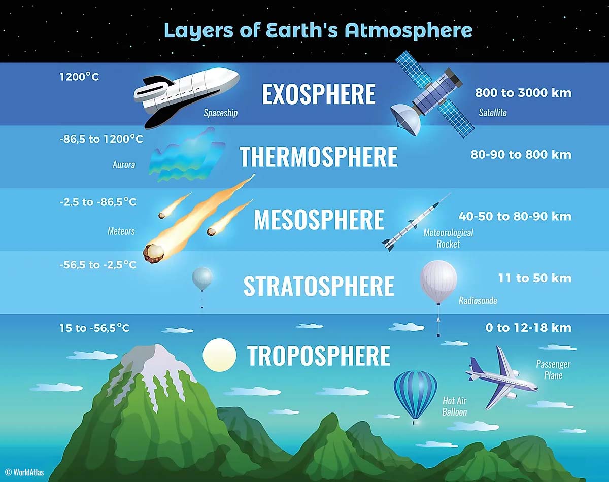
Above this layer is a much deeper one known as the Stratosphere, an 11-50 km thick layer of arid air. Another essential feature in the stratosphere, which makes our weather even more variable, often triggers large-scale, long-lasting winter weather events.
This is the Polar Vortex—an enormous, tri-dimensional ring of powerful winds moving through the sky above us. The Polar Vortex is spinning around the North Pole, grazing through the air at about 20-50 km above the Earth’s surface with violent wind speeds.
The troposphere and stratosphere are crucial for our climate. The Polar Vortex covers most of the bottom half of the atmosphere. Since the vortex extends from the middle of Earth’s troposphere into the stratosphere layer, it significantly affects winter weather across high and mid-latitudes yearly.
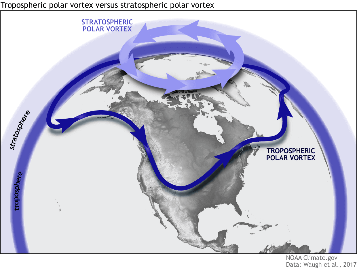
As shown in the image above, we monitor two atmospheric layers during wintertime: the troposphere and the stratosphere. The first is the lowest layer, and the second is at a higher altitude. The Polar Vortex rises through both layers, but with different strengths, shapes, and impacts.
For this reason, we separate the entire Polar Vortex into an upper (stratospheric) and a lower (tropospheric) part. When the Polar Vortex is strong, it traps colder air in the polar regions, preventing its escape and creating milder conditions for most of the United States, Europe, and other mid-latitudes.
Below is an example of how a disrupted Polar Vortex brings cold polar air into the United States and Europe.
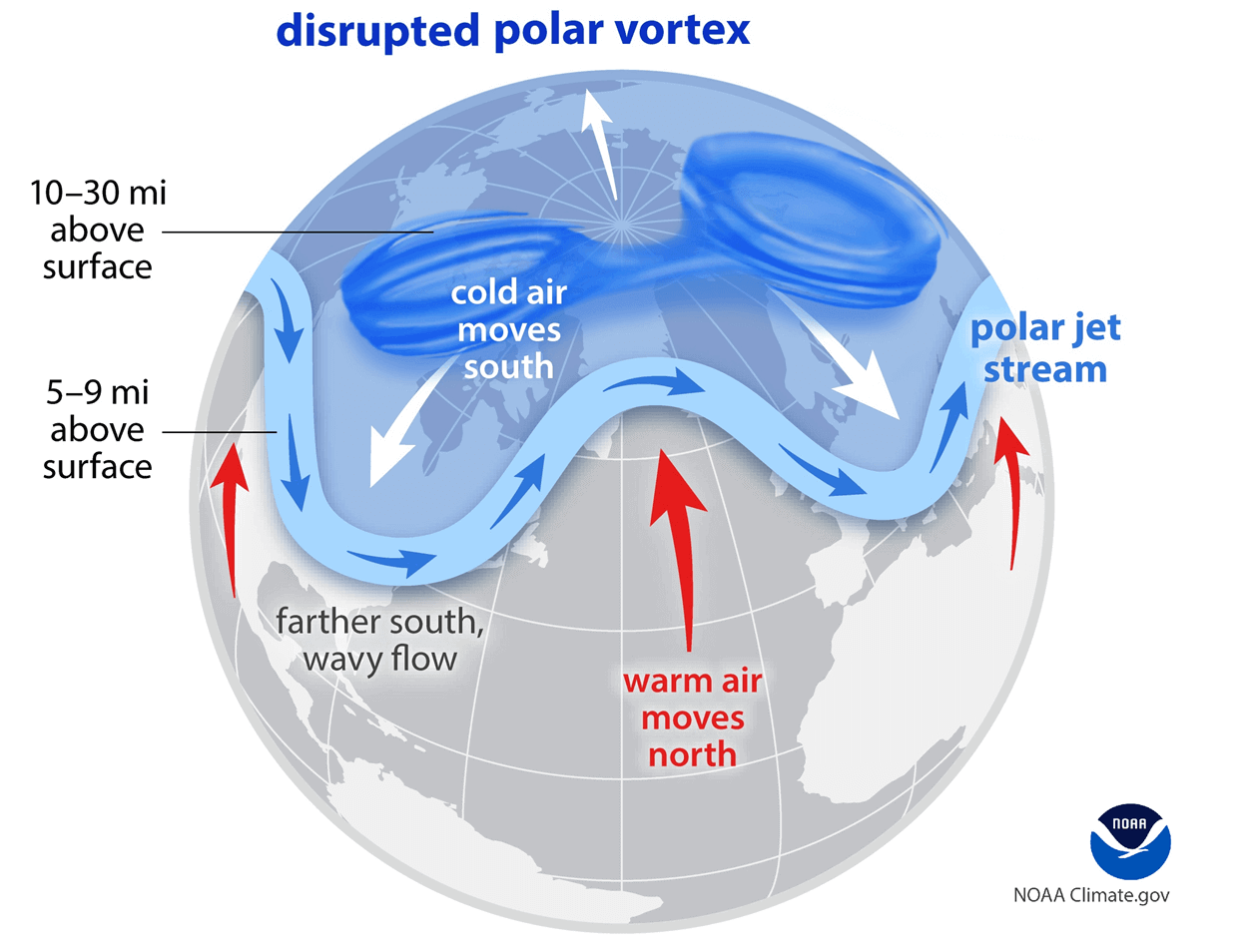
But when the Polar Vortex gets disrupted or even entirely collapses, it can’t fully contain the cold air, which can now easily escape from the polar regions into the United States or other mid-latitude regions.
Blocking High over the North Pacific and Alaska forms, opening a corridor for Arctic cold outbreaks into Canada and the U.S.
The general weather pattern over Canada and the United States indicates that a broad and robust blocking High has developed over the North Pacific, Alaska, and western Canada. This is resulting in a northerly, meridional flow from the Arctic, extending far southward into the U.S.

This weekend, an upper wave travels from the Northern Rockies towards the Midwest and the Great Lakes, with a surface low-pressure system forming a major Winter Storm Bellamy. An intense snowstorm will follow.
The following pressure chart for Saturday indicates the surface low centered over Illinois. This is the winter storm that will blanket millions along its path across the Midwest to the Great Lakes. Behind the wave and the low, pressure rises underneath the building ridge from Canada.
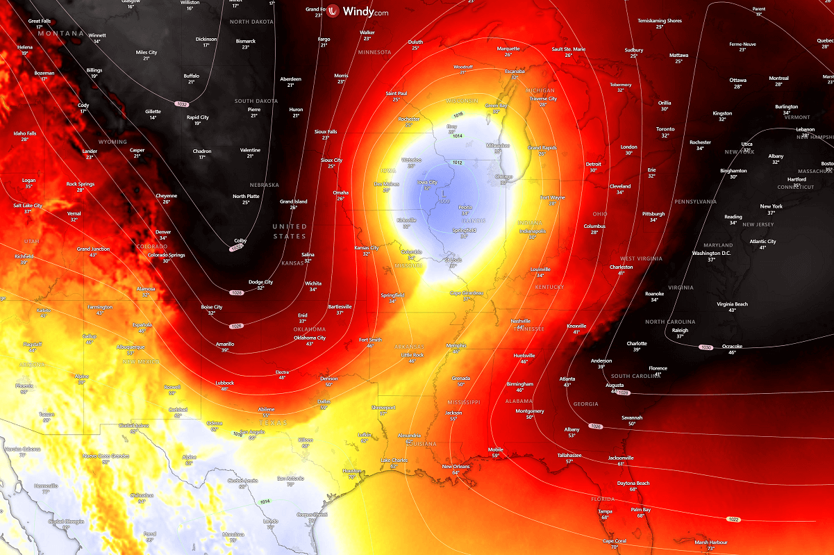
Under the upper ridge, an Arctic cold air mass rapidly spreads from Canada into the central CONUS on Saturday, reaching the central Plains by evening. A temporal warmth can be seen dragged north across the central Mississippi Valley, delivering high moisture into the winter storm.
Over the course of Saturday night, the Arctic cold air mass will continue to move south and east across the central U.S. as the storm Bellamy continues moving east across the Great Lakes.
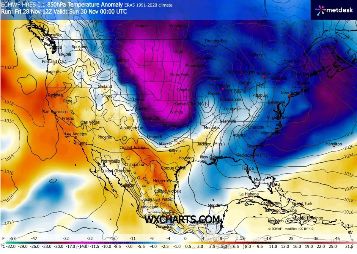
The impact of the clash between the Arctic cold air mass and the high moisture advected from the deep south will be significant.
Winter Storm Bellamy brings a major snowstorm across the Midwest and Great Lakes
The primary focus of the upcoming upper wave is Winter Storm Bellamy, which impacts tens of millions across the Midwest and Great Lakes Saturday into Sunday.
As the wave advanced onto the Great Plains, the surface low deepened and precipitation increased. Storms and rain from Kansas and Missouri towards the south, but moderate to heavy snow further north.
Conditions rapidly deteriorate Saturday late morning into midday as the clash of cold from the north and high moisture from the south increases the heavy snow. Whiteout conditions, with blowing snow, are expected. By Saturday afternoon, the low moves towards northern Missouri and Iowa, spreading intense snowfall across Iowa and Illinois.
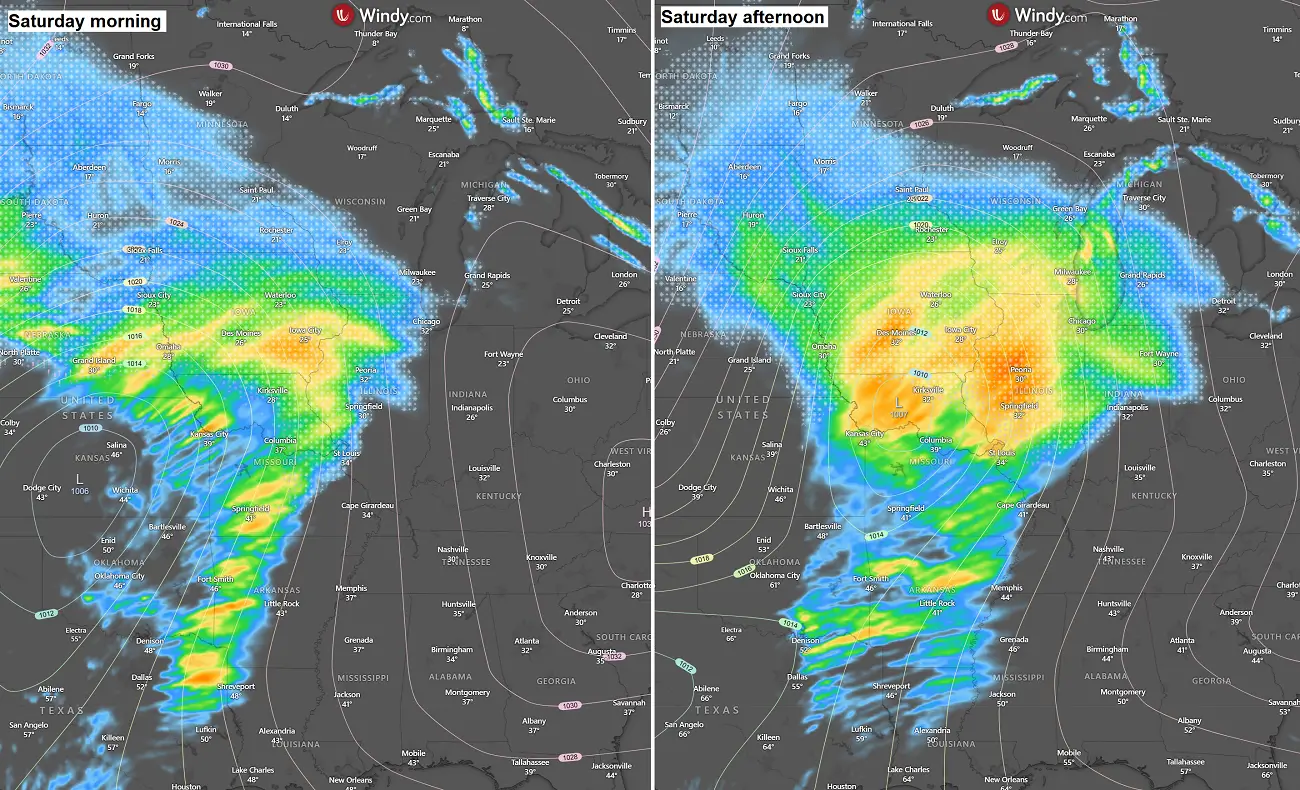
Towards Saturday evening and into the night, the winter storm Ballamy results in heavy snow across northern Illinois and Indian, into southern Michigan. Combined with strong winds, conditions will be extreme with blowing snow and locally near-blizzard conditions. Roads may become impassable.
Snowfall rates will reach 3-4″ per hour, with rapid snow accumulations, disrupting travel and causing delays. Chicago, Illinois, to Grand Rapids and Detroit, Michigan, will be heavily impacted by this intense snowstorm. Roadblocks, long delays, and airline travel cancellations are expected.
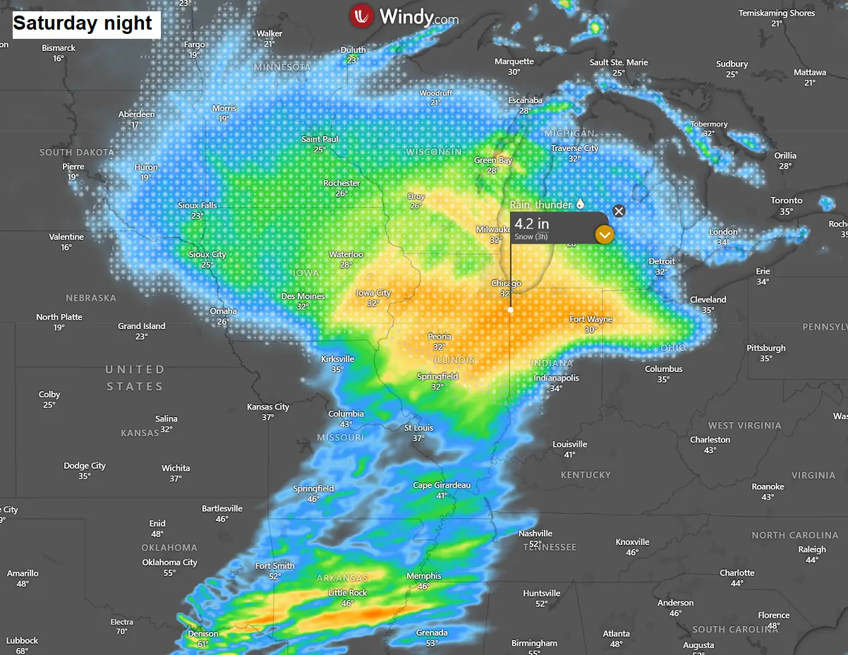
As a result of a slow-moving and intense snowstorm, high snow accumulations are forecast along the storm Belammy’s path. The most significant impact is expected across eastern Nebraska, Iowa, and southern Minnesota and Wisconsin, with the worst conditions across north and central Illinois.
A deep snow blanket will also spread across northern Indiana and Ohio, as well as most of Michigan. Expect around a foot of fresh snow in major cities, e.g., Des Moines, Iowa; Peoria and Chicago, Illinois; Milwaukee, Wisconsin; and Grand Rapids and Detroit, Michigan, on Saturday into Saturday night.
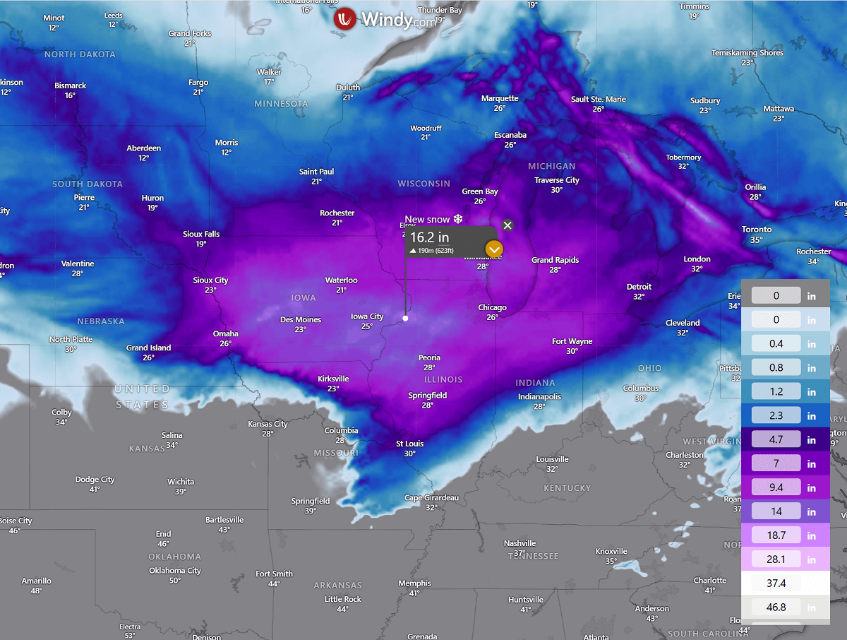
Winter storm Bellamy will gradually weaken on Sunday as the low moves further east across the Great Lakes and southern Ontario, Canada.
We are closely monitoring the evolution of the progressive patterns across the US and Canada, as they will most likely be significantly impacted by the early disruption of the Polar Vortex aloft this winter season. Forecast updates will be required in the coming days as new winter storms and Arctic cold outbreaks follow.
Windy, TropicalTidbits, and Wxcharts provided images used in this article.
See also: