So far, February 2023 has been one of the warmest on record, and well-above-warm weather across a large part of the Midwest and Northeast U.S. February is also known as the month with the most winter storms across the country. As an effect of the Polar Vortex collapse earlier this month, a significant Arctic Blast will spread from Canada into the northern United States this week. A Winter Storm Olive will develop along the Arctic cold front, forecast to blanket the Midwest and part of the Great Lakes region with deep snow and a major ice storm.
A swath of heavy and deep snow will develop from the Northern Rockies across the Dakotas to Upper Midwest, extending into the Great Lakes and southern Ontario, Canada. Areas from South Dakota across southern Minnesota to Wisconsin could see considerably big snowstorms and blizzards. Travels will be difficult to impossible in places due to snow drifts and blowing snow.

A concerning feature is a very sharp temperature gradient along the Arctic front, with a significant warm air mass aloft battling with the major cold near the surface. This hints at a high risk of the ice storm from central Iowa to northern Illinois and southern Michigan late Wednesday into Thursday morning.
Despite weather models still having some uncertainties regarding the exact swath of freezing rain, large cities like Chicago and Detroit could also be in their path.
Portions of the northern U.S., from the Rockies to the Upper Midwest, are already under the effect of winter storm watches and warnings ahead of the incoming Winter Storm Olive. Areas are expected to be upgraded as the storm unfolds late Tuesday into Wednesday and Thursday.

The significant weather impact forecast through mid-week is due to the amplified pattern across North America. The collapsed Polar Vortex aloft has changed the pattern across the continent, sending a powerful Arctic Blast from Canada into the northwestern U.S.
Ahead of it, the record warmth across the Southeast U.S. will maintain and advance further north. This happens in response to the surface low forming along the sharp Arctic front. The overlapping of a very warm mid-level airmass from the south with cold near-surface conditions over the Upper Midwest and the western Lakes will lead to heavy snow and a major ice storm.
As mentioned, the main reason the major winter storm Olive is so widespread is the collapse of the Polar Vortex aloft. A large pool or Arctic air mass plunges southward from the Polar region into the central parts of North America, across Canada into the United States. This also induces the winds aloft. Therefore jet stream is much stronger.
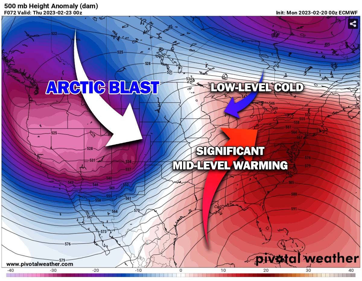
This brings huge temperature gradients across the continent, meaning temperature and pressure differences are large. Thus, potentially introducing stronger winter storms, heavier snow, and, as we see, also ice storms and blizzards that span across a large portion of the nation.
The jet stream that digs far south around the upper deep core on the West will push very warm air mass from the subtropical region into the Southeast and East Coast, resulting in record-breaking warmth at the end of February. This warmth clashes with the plunging Arctic air, leading to a violent winter storm.
Significant travel impacts are expected across the region. Some locations can expect to see at least a foot of snow by the time Olive ends Thursday night. With the worst conditions from Wednesday evening through Thursday.
Heavy snow combines with northeast wind gusts of 30 to 50 mph, leading to significant drifting snow and whiteout conditions in open areas.
In the wake of the winter storm Olive, much colder Arctic air is expected to plunge into southern Canada, gradually expanding into the northwestern U.S. and northern Rockies through mid-week. Freezing weather will continue spreading east into Dakotas and Upper Midwest through Thursday and Friday.
It will remain very warm to the south, with temperatures in the mid-70s to mid-80s across Southeast U.S. Let’s now take a detailed view of the potential impacts as the new significant weather system emerges this week.
WINTER STORM OLIVE DEVELOPS ON LATE TUESDAY, STRENGTHENS OVER THE ROCKIES AND HEADS TOWARD UPPER MIDWEST ON WEDNESDAY
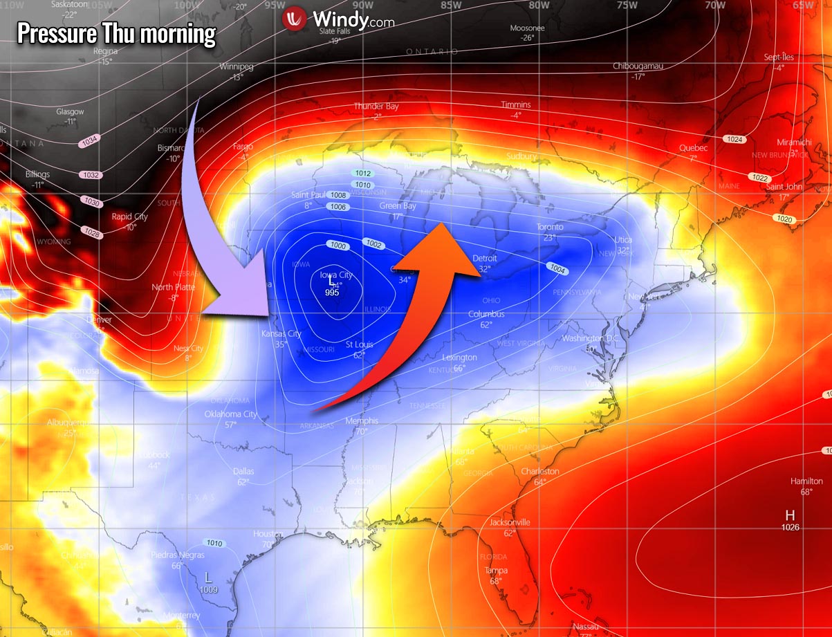
The new wave emerges into the northern Rockies with Tuesday’s rapidly developing winter storm. The surface low then considerably strengthens while moving across the High Plains before turning towards the Midwest.
So, this week’s general weather pattern across the Contiguous U.S. reveals a large upper-level wave emerging from the west and an upper High across the East Coast. Developing a deep frontal system across the central Rockies into the Plains late Tuesday.

In between, a powerful jet stream spread across the Rockies, allowing the surface low to deepen into a major winter storm as it tracks across the northern states on Wednesday. A high potential for a wide swath of deep snow for tens of millions across more than 10 states.
As the colder Arctic air plunges south from Canada into the northern Rockies, the surface low will gradually deepen its central pressure while moving east-northeast Tuesday night into Wednesday. At the same time, the high-pressure system builds up to its north-northwest towards southern Canada.
This results in wind flow turning more northerly across the Northern Plains, delivering a significant, frigid cold towards the core of the winter storm Olive.

While at the same time, deep moisture is being dragged from the Gulf of Mexico northward, resulting in widespread heavy precipitation for the Midwest. High humidity also transports into the cold side of the Arctic front, fueling the heavy snow across parts of the northern Plains.
The new winter storm will be tracking east and impact mainly the northern states, from Montana and Wyoming across Dakotas to Minnesota, Wisconsin, and Illinois to Michigan through Thursday. And continue farther east-northeast across portions of the Great Lakes region and southern Ontario.

The pressure gradient along the moving winter storm’s surface low will also increase the winds, developing blizzard conditions. But with a more concerning evolution on its front end. As the low moves across the Midwest, the strong advection of much warmer airmass spreads far north. Forecast to overcome the cold which remains near the surface.
While heavy snow and blizzards will intensify across the eastern Dakotas and Minnesota Wednesday afternoon into the night, the increasing potential for significant freezing rain and ice storm appears for southern Wisconsin, northern Illinois, and southern Michigan.
Chicago, IL, and Detroit, MI, could be heavily impacted by a major ice storm and a huge accumulation of freezing rain and black ice.
UP TO TWO FEET OF SNOW LIKELY ALONG THE PATH OF WINTER STORM OLIVE
Associated with the upper trough digging into the West, heavy snow with strong winds has developed over the Northern Rockies Tuesday morning, forecast to spread southward across the Central Southern Rockies on Tuesday and Wednesday. The surface low-pressure system will move into the Plains on Tuesday night and spread heavy snow, increasing winds freezing rain across the Northern Rockies, Upper Midwest, Great Lakes, and interior Northeast on Wednesday.
The amounts of snow will be the most abundant and heavy along and to the north of the core of Olive. Weather models agree that a swath of heavy deep snow will extend from central Montana and northern Wyoming to Minnesota, Wisconsin, and north-central Michigan. As well as into southern Ontario and further to the northeast interior.

Snow totals could be between 2-4 feet, with locally higher amounts possible in the Western mountains. Meanwhile, by Thursday morning, 1-2 feet of snow is likely from the Northern Plains and Midwest to the interior Northeast.
This will bring large cities into the impact of heavy snow, including Billings, Rapid City, Sioux Falls, Minneapolis, Milwaukee, Green Bay, and Grand Rapids.

Winds will be gusting 35-50 mph and are forecast to cause blizzard conditions over portions of the West and Midwest on Wednesday. Expect power outages and tree damage in some areas.
The Minneapolis-St. Paul metro area could see its heaviest snowstorm in at least 12 years. 18-20 inches or even more would break February’s record. The existing record is 13.8″ from a single winter storm event. Nevertheless, parts of western and southern Minnesota could see up to 2 feet of snow.

Further Northeast, the snow, freezing rain, ice, and rain zones will spread into northern Ohio and much of the central parts of Pennsylvania. Toward central New England, freezing drizzle may occur in the more elevated areas; bridges may become icy and disrupt travel.
The northeastern branch of the heavy snow swath will develop on the northern parts of Vermont, New Hampshire, and Maine, with 15-20 inches of snow forecast to fall. Elsewhere, around 5-12 inches of snow is likely for much of coastal Maine and far Upstate New York.
Travel delays, including airline delays, are expected.
MAJOR ICE STORM WITH FREEZING RAIN EXPECTED FROM EASTERN IOWA TO NORTHERN ILLINOIS AND SOUTHERN MICHIGAN
A combination of snow and ice is expected to ramp up over the Upper Midwest, Great Lakes, and Northeast Wednesday night into Thursday. The bulk of the freezing rain is expected to accumulate, leading to dangerous travel conditions.
Areas to the east-southeast of the storm’s core and the heaviest snowfall will take advantage of the massive return of much warmer air aloft. Therefore, weather conditions will develop a narrow band of sleet and freezing rain, especially across from east-central parts of Iowa into northern Illinois, Wednesday night. And continue into extreme north Indiana and southern Michigan Thursday morning.
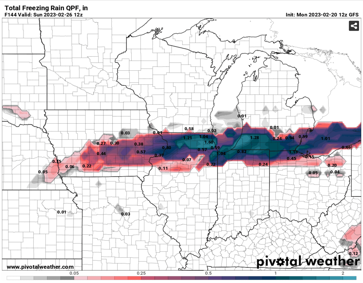
Significant ice amounts of a half-inch to 1.5″ are possible from northern Illinois into southern Michigan, leading to slippery travel conditions, power outages, and potential tree damage. Roadways may become icy and could be closed.
The major ice storm will likely be the worst across southern Michigan, as seen on the weather chart below for Wednesday night into Thursday morning. The most intense precipitation with heavy freezing rain is in southern Michigan. Farther north, heavy snow is forecast.
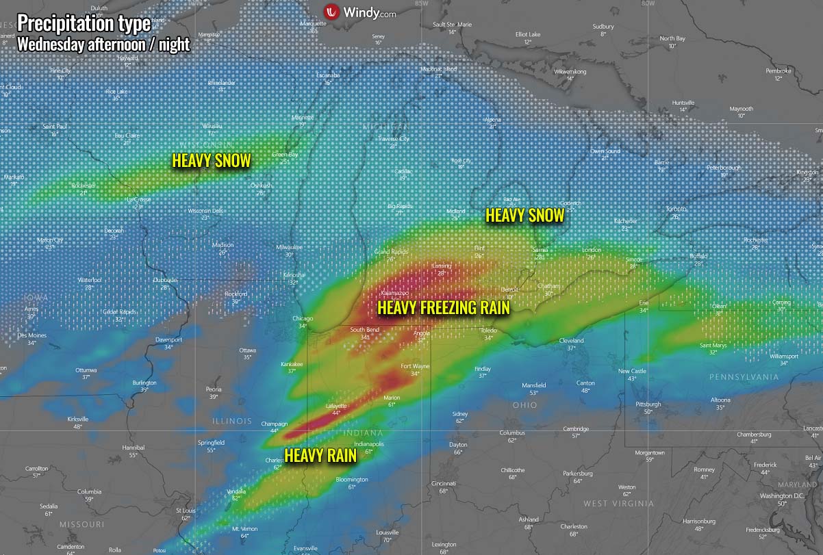
The heavy freezing rain and black ice could also lead to Detroit’s Airport closing for several hours, triggering numerous flight delays and cancellations. It is advised to plan accordingly.
WHAT IS SLEET OR FREEZING RAIN?
Freezing rain generally forms when a layer of warm air aloft is placed above a layer of below-freezing (subfreezing) air at the surface. Snowflakes that fall toward the ground melt as they fall through this warm layer.
If the flakes are melted completely, they fall as rain toward the much colder ground. The liquid droplet then freezes on contact with exposed surfaces.

Sleet or ice pellets are a form of precipitation consisting of small and translucent ice balls. Ice pellets are smaller than hailstones and are different from graupel. Ice pellets also bounce when they hit the ground or other solid objects (e.g., jackets, windshields, and dried leaves). They generally don’t freeze into a solid mass unless falling mixed with freezing rain.
Behind the storm Olive, temperatures are forecast to become much lower with time from north to south from Wednesday thru Friday as the winter storm advances further east across the Great Lakes region. Much colder weather with Arctic temperatures will spread from southern Canada into northern states. Then continuing into the northern Plains, Midwest, and further towards the Lakes and Northeast U.S. late this week.
A NEW BLAST OF ARCTIC COLD AIR MASS FOLLOWS IN THE WINTER STORM’S WAKE FROM CANADA INTO NORTHERN STATES
With the developing High on the West and Canada under the large Arctic cold pool, the frontal system will drag much colder air across the central parts of the continent after Wednesday. Temperatures are forecast to be around 20-40 °F lower than normal for late February.
The 850 mbar temperature anomaly is attached below, indicating that the significant cold first stays over British Columbia and southern Alberta before spreading into Montana and its surroundings. While to the south and east, a major warmth is further increasing. Resulting in record-breaking warmth for the Southeast U.S.

A sharp temperature difference develops between both cold and warm reservoirs. Here is where the Arctic front is placed and surface low forms.
Looking closer at this sharp temperature contrast across the Great Plains, we can see a nearly 80 degrees F difference is about 420 miles will exist on Wednesday afternoon. While Chadron, Nebraska, will already be blasted by frigid cold weather and winds, pushing temperatures to around -6 °F (-21 °C), Wichita, Kansas, will enjoy the spring-like weather ahead of the front.
Wichita, with 73 °F (or 23 °C), is just a few hours drives away. That is extreme!

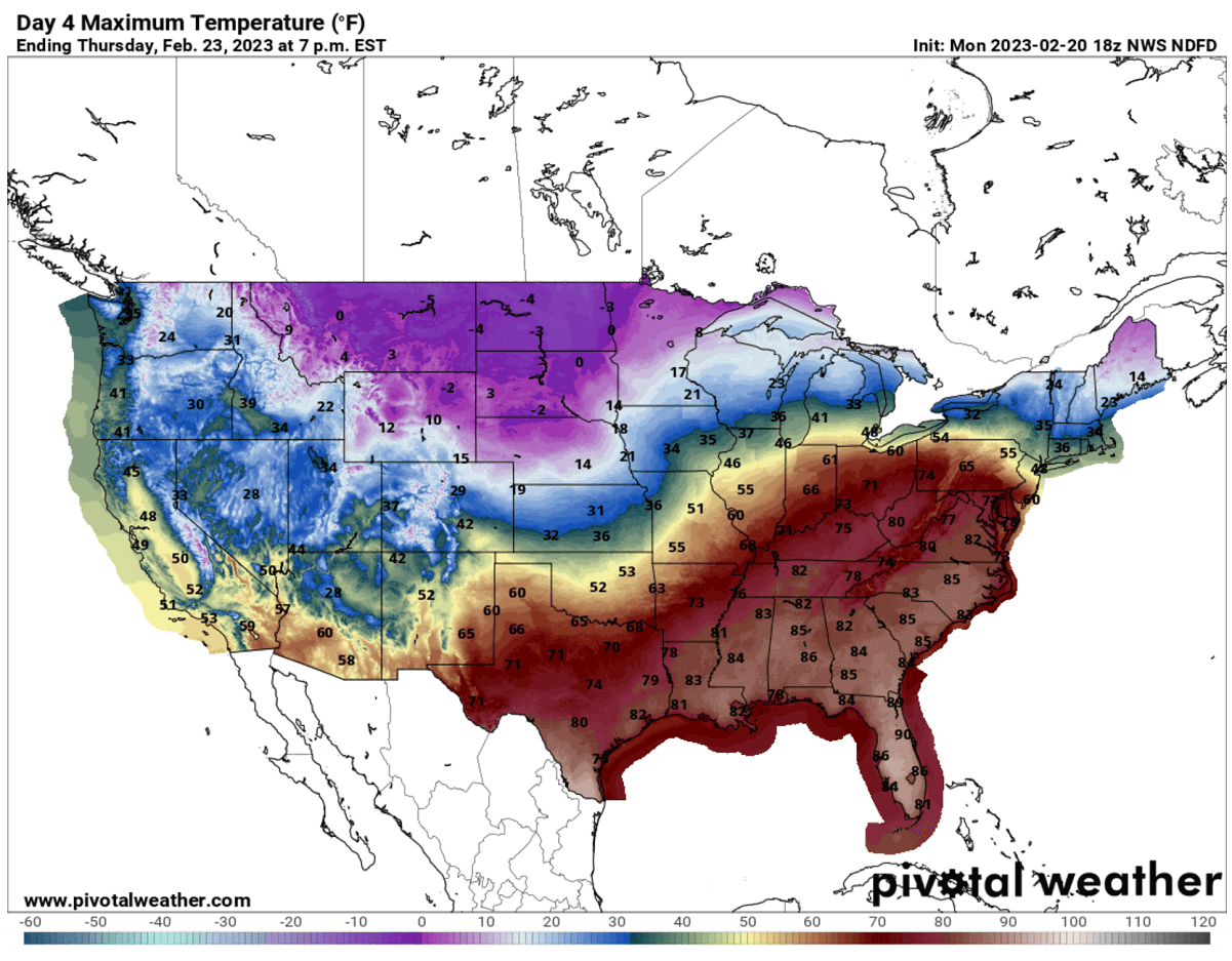
The cold behind storm Olive will intensify Wednesday night into Thursday. Temperatures are forecast to plunge below -15 °F across Wyoming, Montana, Dakotas, and most of Minnesota on Thursday morning. Single digits to nearly -10 °F across central Nebraska, Iowa, and Wisconsin. Two-thirds of the country will be below freezing, as we see below.
The deep South will remain very warm, thanks to southern winds and high moisture recovering towards the frontal system to the north.

Temperatures will remain below freezing for most of Thursday and Friday across the North, with negative °F from Montana and Wyoming to Dakotas and Minnesota.
Meanwhile, Thursday will bring incredible warmth with record-breaking high temperatures for the southern, Southeast, and East Coast. Peak temperatures will be in the mid-80s, closing to 90 °F in central Florida. Creating an impressive temperature contrast nationwide.
The overlook across the whole North American continent on Thursday and Friday reveals how large the cold pool will develop. Temperatures will be around -35 °C across southern Alberta, Canada. Similar in parts of Montana and North Dakota.
The Polar front is also visible, separating very cold from very warm air across the central US. Extending across thousands of miles from the central Plains to Northeast U.S. and far eastern Canada.

High pressure will maintain across the North, gradually vanishing the cold toward the weekend. To the south, another warm wave is forecast to develop into the last days of February. In addition, another frontal system could follow early next week.
Windy, Pivotalweather, and Wxcharts provided images used in this article.
See also: