As Winter begins, a major blocking pattern emerges over the Northern Hemisphere. High-pressure systems will push into the polar regions, creating a series of weather changes. The circulation will be disrupted, releasing colder air from the north and creating an actual split of the lower Polar Vortex.
We will look at the upcoming significant pattern changes across the Northern Hemisphere and the general weather forecast for December 2022. You will also see how weather systems can split the Polar Vortex into two separate parts from below.
Polar Vortex is generally a loose and broad term. But it represents the Winter weather circulation and many changes and effects that come with that throughout the atmosphere.

POLAR CROWN OF WINTER WEATHER
As we head into autumn, the polar regions start to cool. As the Sun angle lowers, less energy reaches the polar regions. But as the polar temperatures drop, the atmosphere further to the south is still relatively warm as it continues to receive light and energy from the Sun.
This causes a strong global temperature difference between the polar and sub-tropical regions, and a large low-pressure (cyclonic) circulation develops across the Northern Hemisphere. It extends from the surface layer far up into the Stratosphere. This is known as the Polar Vortex.
We produced a 3-dimensional image of the Polar Vortex, extending from the lower levels into the Stratosphere. The vertical axis is greatly enhanced for better visual presentation. As a result, you can see what the real structure of the Polar Vortex looks like.
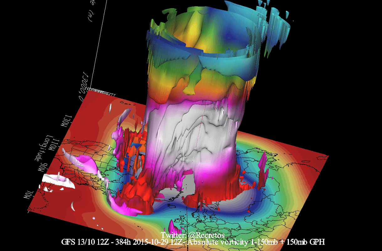
The upper (stratospheric) part of the circulation is usually more circular and symmetrical as it spins higher above the ground. But the lower structure of the polar Vortex is much more uneven and disrupted. That is due to the influence of the terrain/mountains and strong pressure systems acting as obstacles in the flow.
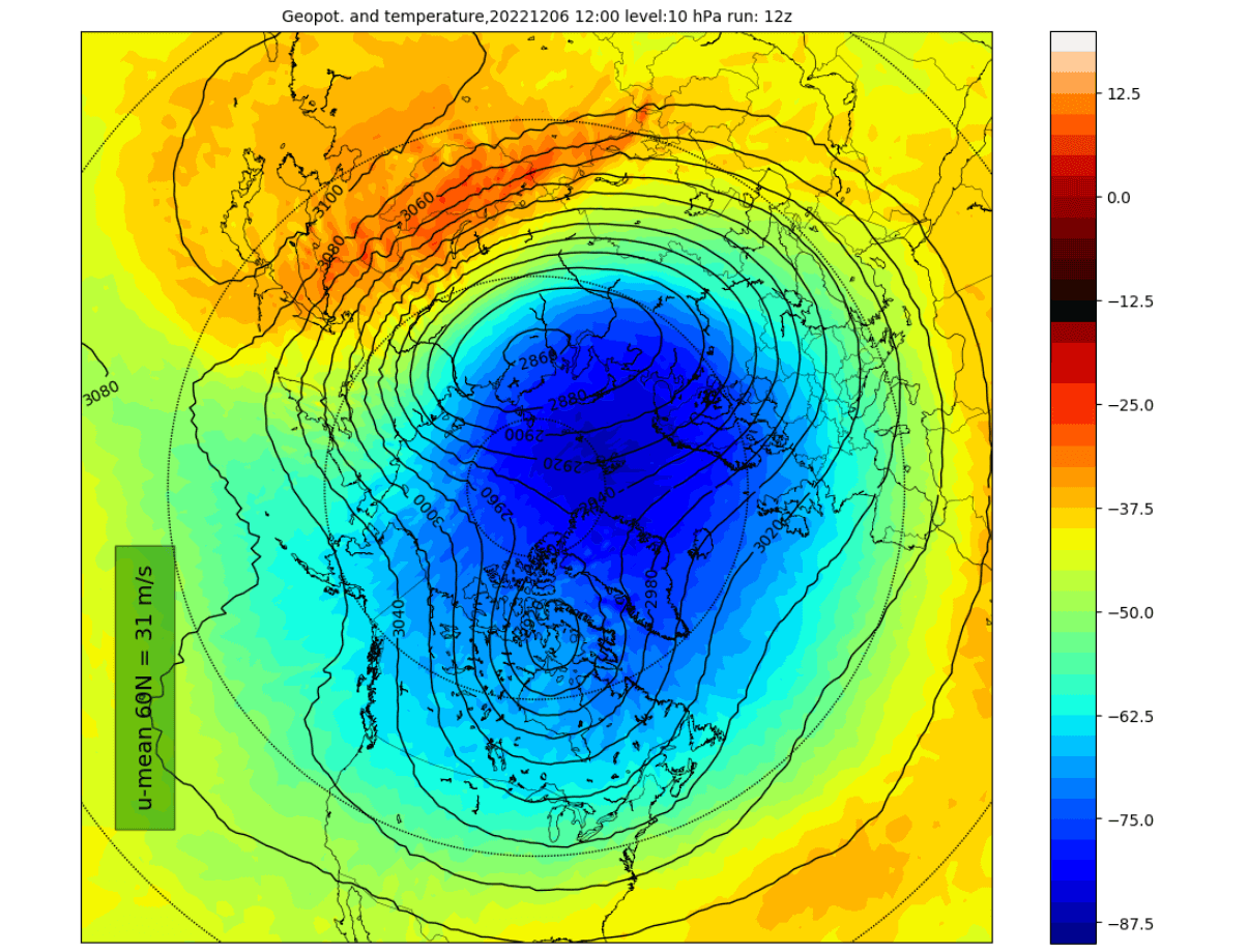
The image below shows the normally shaped high-altitude Polar Vortex at around 30km/18.5miles in the middle Stratosphere during Winter. It is circular, with the temperature dropping as you get closer to its inner core.
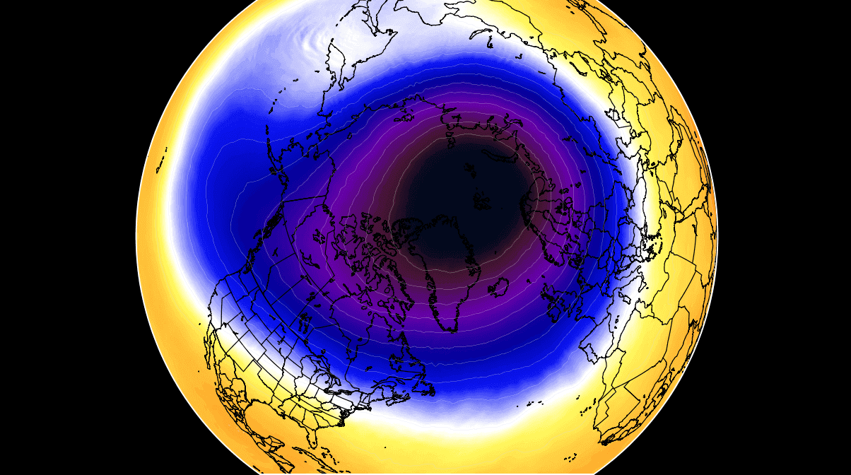
The stronger winds around the Polar Vortex at this altitude are called the “Polar Night Jet”. Winds are significant when talking about the polar Vortex, as they are usually the first to show that something in the polar Vortex is changing.
In the next image below, we have the lower levels of the polar Vortex at around 5km/3miles. The closer to the ground you go, the more deformed the polar Vortex gets. That is because it has to interact with the rough terrain and many pressure systems.
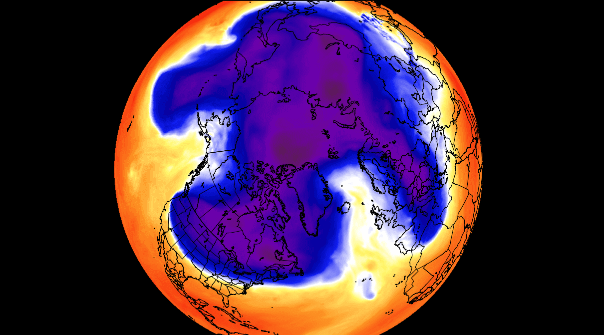
Notice the “arms” extending into the lower latitudes, bringing along colder air and snowfall. These arms also pack a lot of energy and can create strong winter storms, like a Noreaster’ in the United States or cold air outbreaks in Europe.
So to recap, the Polar Vortex behaves like a very large cyclone, covering the whole north pole down to the mid-latitudes. It is connected through all atmospheric levels, from the ground up, but usually has different shapes at different altitudes.
So the reason we monitor any Polar Vortex activity closely is because it can have weather implications across the Northern Hemisphere. And that is regardless if it is weak or strong, connected or disconnected.
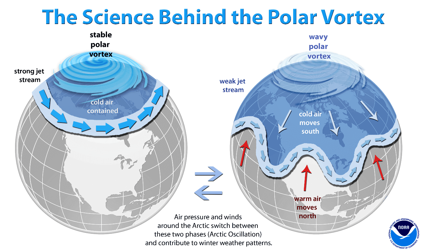
A strong Polar Vortex usually means strong polar circulation. This usually locks the colder air into the Polar regions, creating milder conditions for most of the United States and Europe.
In contrast, a weak Polar Vortex can create a weak jet stream pattern. It has a more challenging time containing the cold air, which can now escape from the polar regions into the United States and/or Europe. Image below by NOAA.
To put the Polar Vortex into perspective, we produced a high-resolution video below, showing the Vortex spinning over the Northern Hemisphere in the Stratosphere at the 30mb level, around 23km/14miles altitude.
The main takeaway from the video should be that the Polar Vortex is not just one single winter storm or a cold outbreak that moves from the Midwest into the northeastern United States.
It is a large cyclonic area spinning over the entire Northern Hemisphere, from the ground up to the top of the Stratosphere and beyond, reaching over 50km/31miles in altitude.
THE WEATHER AHEAD
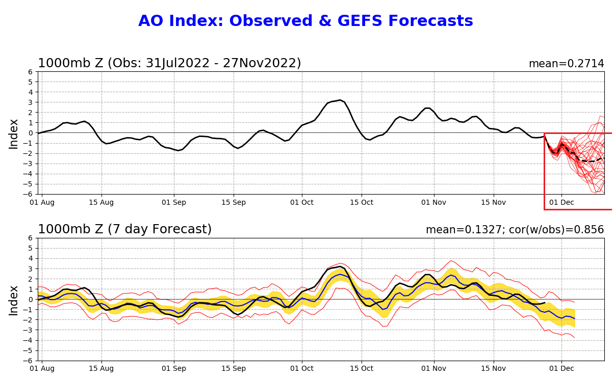
There is one simple way that we usually track the changes in the circulation and the strength of the lower Polar Vortex. It is called the Arctic Oscillation (AO index). High values indicate strong circulation, and low/negative values indicate a weak/disrupted weather pattern.
In the image below, you can see the latest forecast of the AO index. It shows a strong drop in negative values as we get into December. The values are quite significant and indicate a strong disruption of circulation over the Northern Hemisphere.
Such strong changes have a rather direct effect on weather development. But at the same time, this process can start a chain of events that can impact later in Winter.
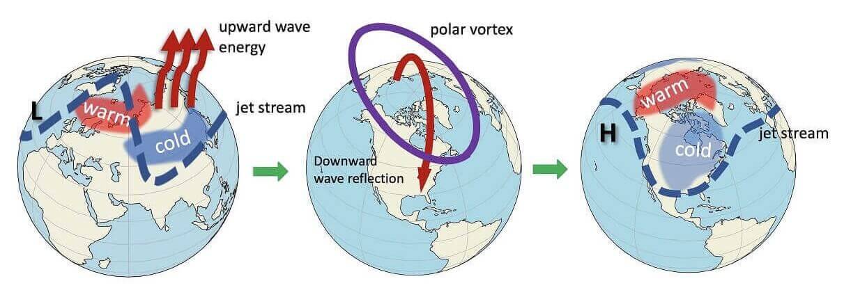
Pressure changes can have an upward impact on the Stratosphere. For example, strong weather systems deflect energy upwards into the Stratosphere, deforming the polar Vortex, temporarily pausing its strengthening or even weakening its circulation.
In the image below, you can see the vertical wave activity example. First, the energy goes upwards into the Stratosphere, which impacts the polar Vortex. A deformed or disrupted Polar Vortex can then affect the polar circulation back down, changing the weather patterns.
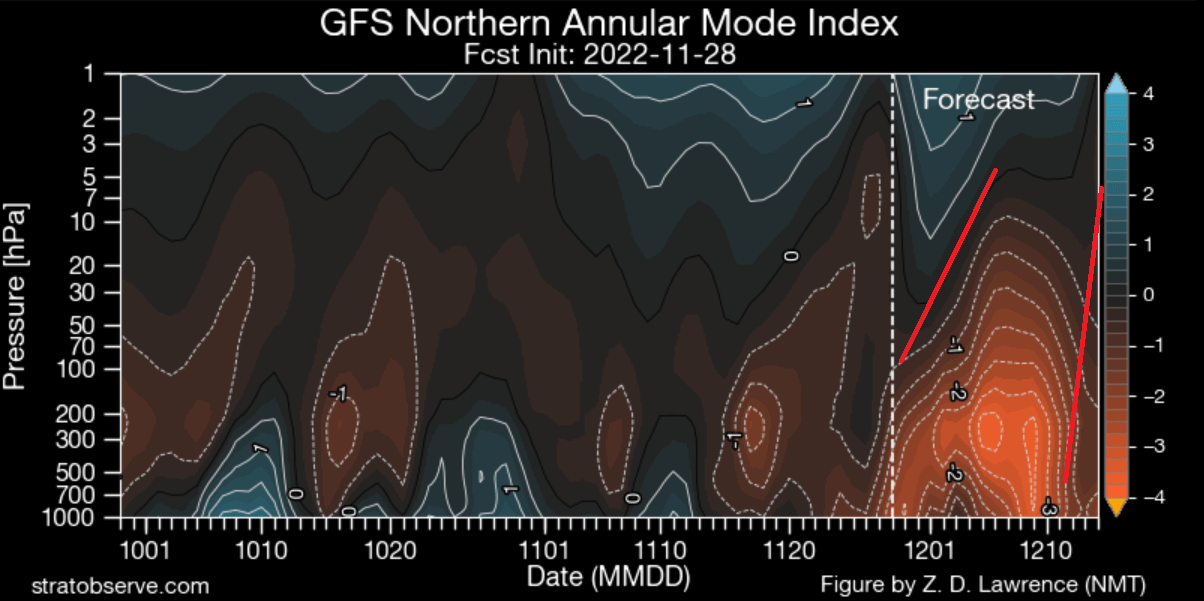
As far as the Stratosphere and weather connection goes, a special graphic puts that into perspective. We usually look at the pressure development from the surface up into the Stratosphere over time.
The next image shows exactly that. Again, you can see strong anomalies in the lower levels of the atmosphere. But over time, they expand and push upwards. As you will see further down in the article, this will have an immediate effect on the Polar Vortex and potentially beyond into mid-Winter.
It is important to capture these processes early, as their significance might be further down the line. The image below shows an average picture of the Polar Vortex collapse events. You can see that there is typically a 15-30 day precursor event in the lower atmosphere.

This shows that early low-level disruptive events can be either a precursor or a sign of a large-scale process at work in the near future.
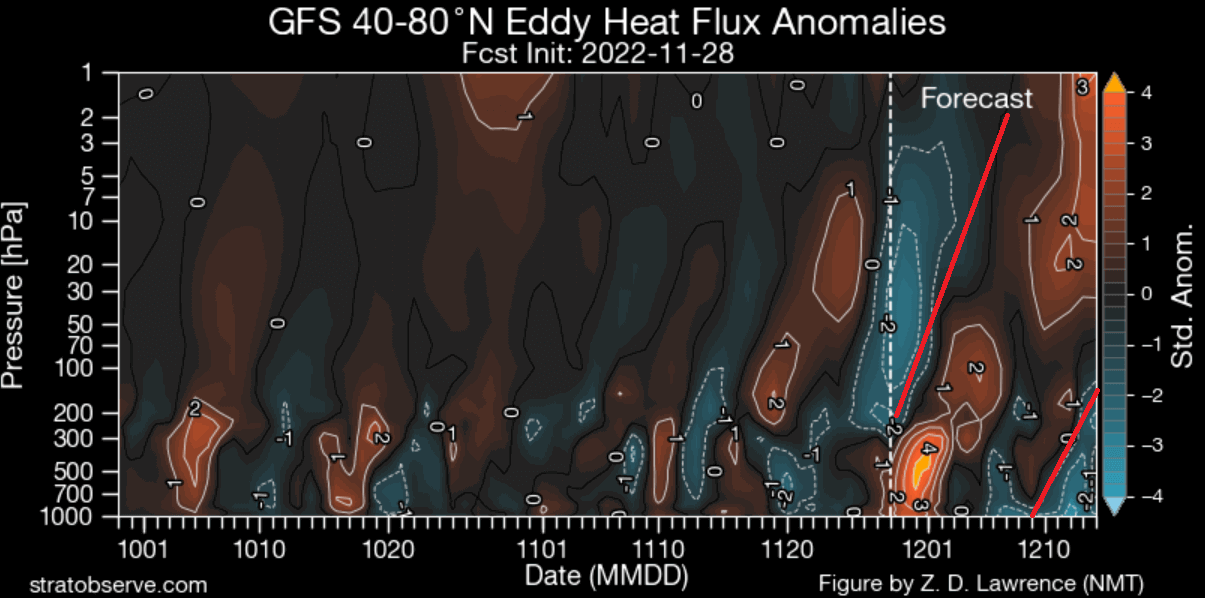
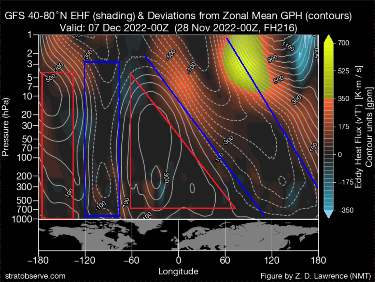
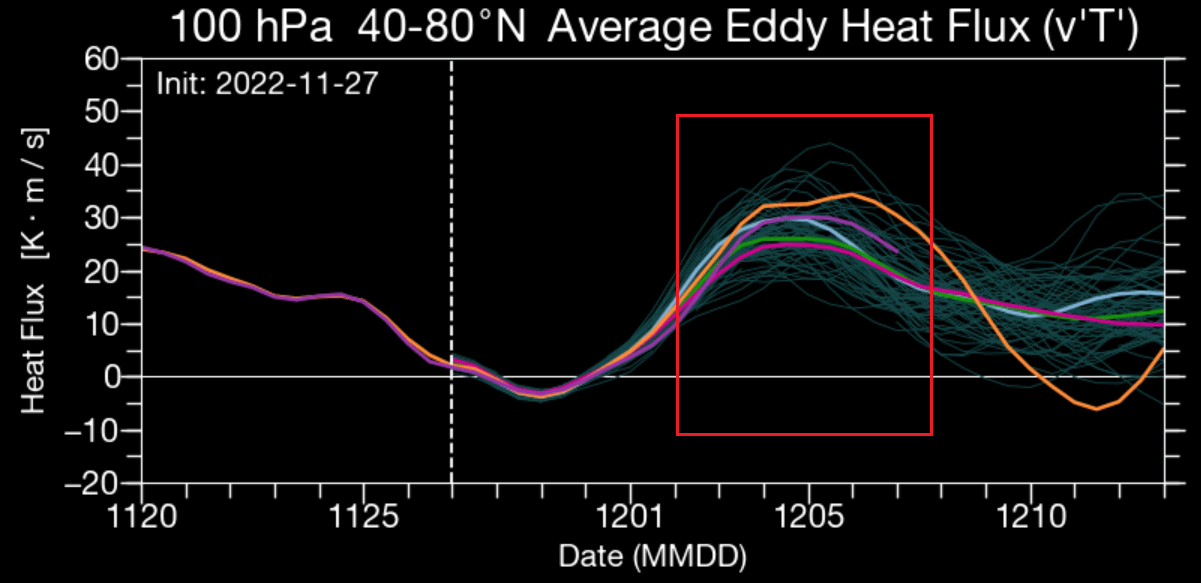
If we look at the heat flux anomalies, we can see an actual upward wave developing now and into December. Marked by the red lines and positive values, you can see the strong “precursor” type upward wave into the Stratosphere.
We will keep a close look at the Polar Vortex development further towards the end of the year. But what is causing these current anomalies, and what are the upcoming pressure changes across the Northern Hemisphere?
WEATHER PATTERN ANALYSIS
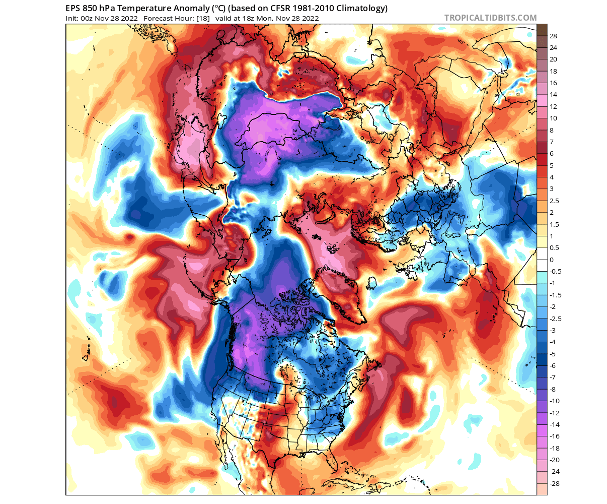
Starting with the current state, we have the 500mb pressure pattern in the image below. There is a low-pressure zone over North America, while we have two high-pressure blocking systems. One is over the North Pacific, and one over northwestern Europe.

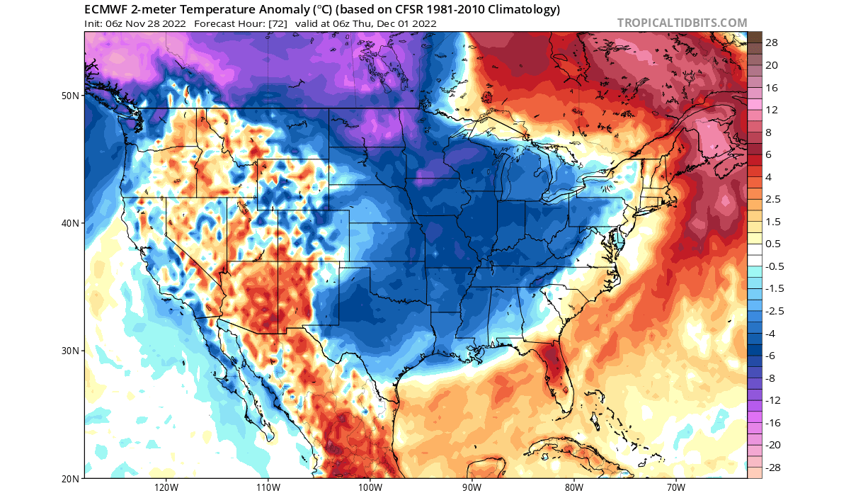
The temperature anomaly pattern shows the cold air over the north pole being squeezed by the two high-pressure systems. As a result, a strong batch of cold air was pushed out into western Canada, expanding down into the northwestern United States.
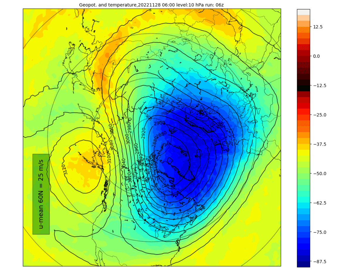
Looking at the stratospheric Polar Vortex, you can see that it is also being compressed. A strong stratospheric high is pressing against it from the North Pacific. It is currently being displaced and slightly deformed.
You can better see that in the 3D analysis below, which shows the vertical structure of the polar Vortex. It is being compressed from the lower to the higher levels, elongating its shape. Image by stratobserve.
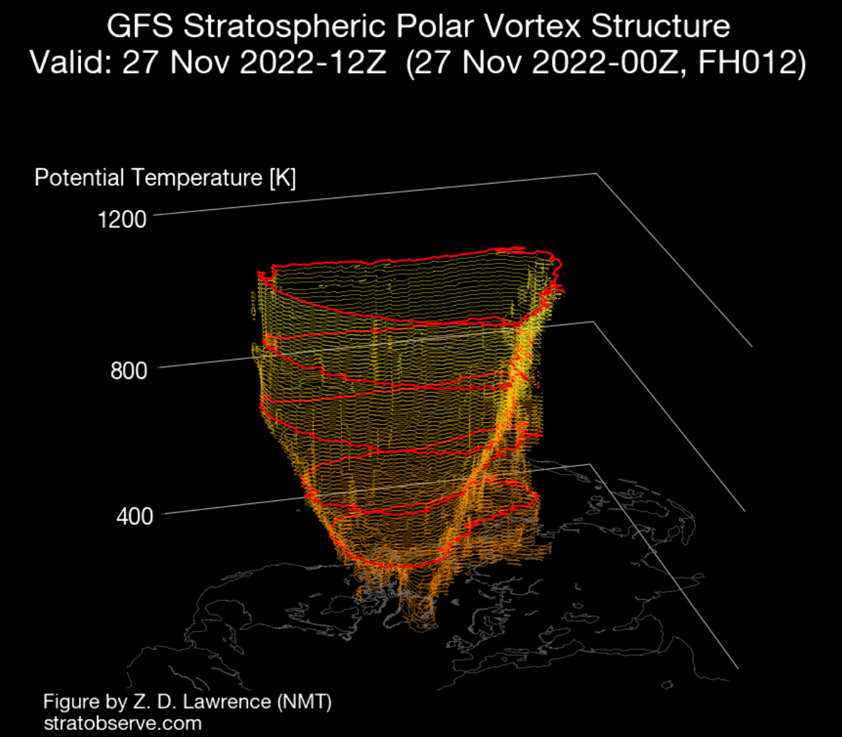
But the near future is looking even worse for the Polar Vortex, as an even stronger blocking high is set to emerge over Greenland.
WINTER WEATHER PATTERN FORECAST – DECEMBER 2022
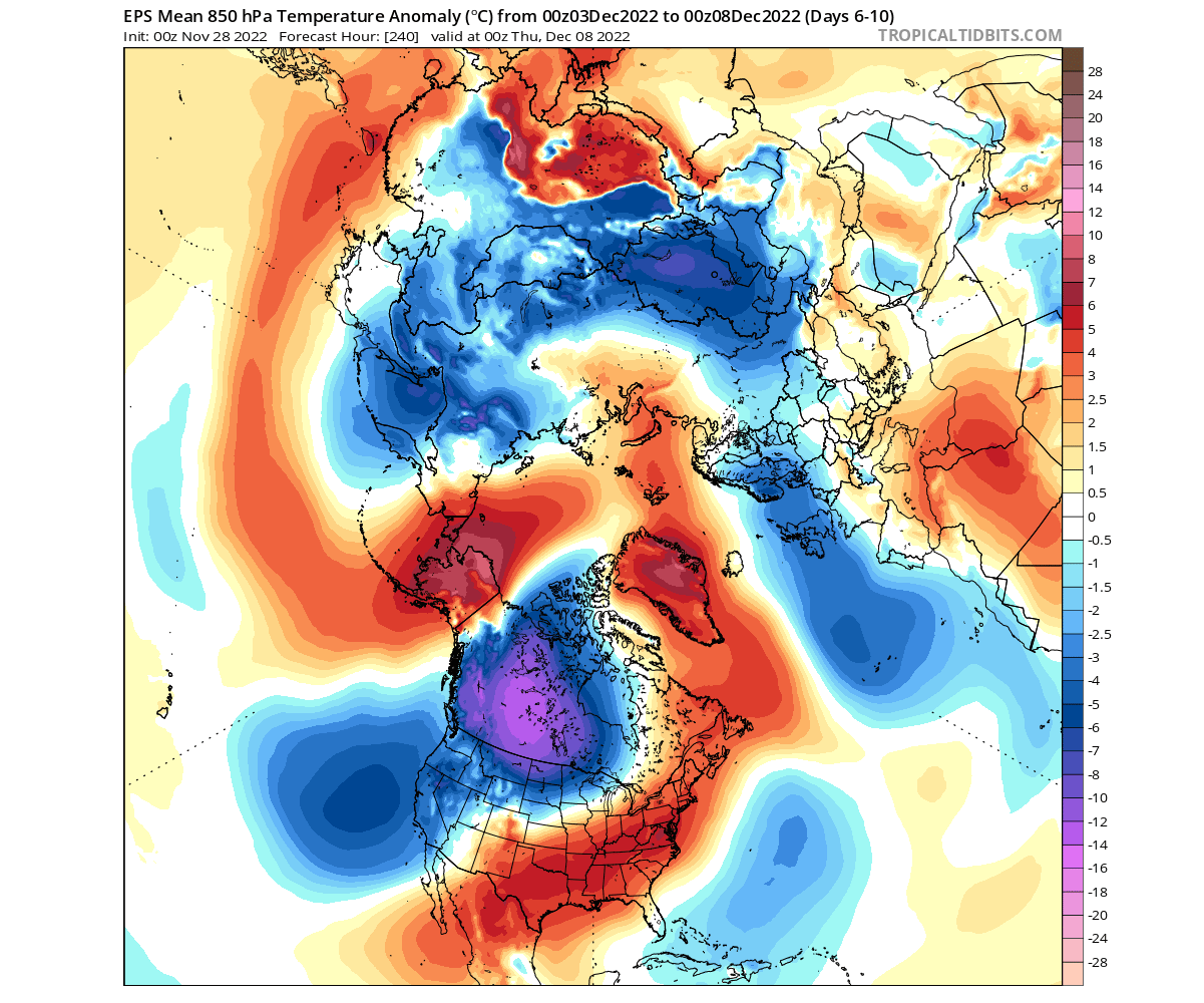
December will start with a continued double-blocking weather pattern. Both high-pressure systems will press further into the polar regions. The low-pressure area over North America will bring down cold air across the United States, and a cold wave will spread over central and northern Europe.
Looking at the temperatures, we can see the cold wave over Europe. But notice the strong warm anomalies reaching into the Arctic circle, pushing the cold air out into Siberia and especially into western Canada and the northern United States.

Looking closer at the United States and southern Canada, you can see the cold wave spreading across the eastern United States. The cold air is sourced from southwestern Canada, first into the Midwest and then further towards the south and southwest.
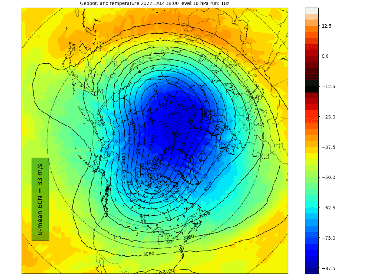
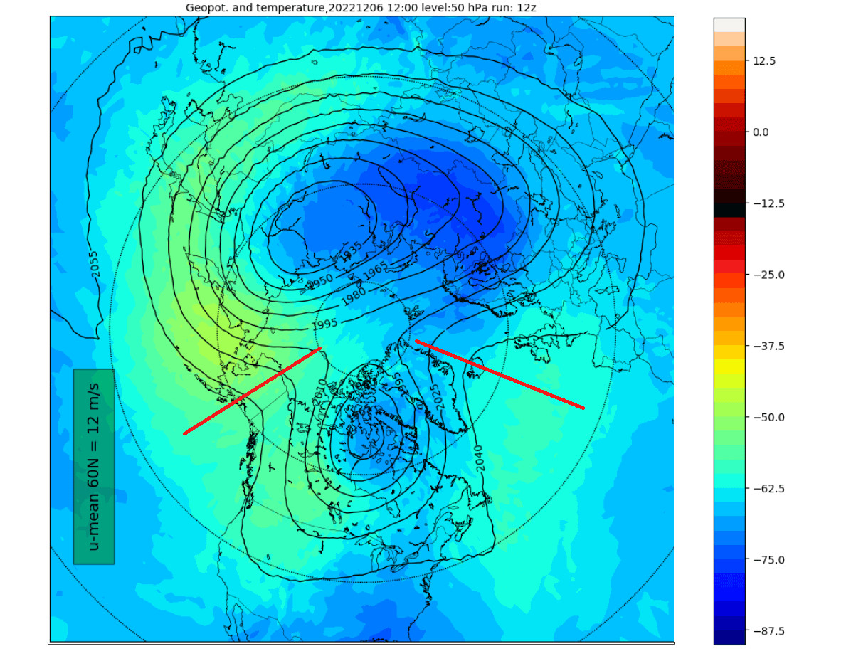
But the strong high-pressure anomalies are also growing in vertical influence and will start to compress the stratospheric Polar Vortex. The image below shows the Polar Vortex at the 50mb pressure level (19km/12miles) in the lower Stratosphere. Notice the effect of the two blocking systems, having a compressing effect all the way upwards into the Stratosphere.

Looking at the mid-stratosphere at the usual 10mb level (30km/18.5miles), we can also see the Polar Vortex being compressed from the North Pacific and North Atlantic sides, but the effect is weaker at this altitude.
BLOCKING PATTERN EVOLUTION
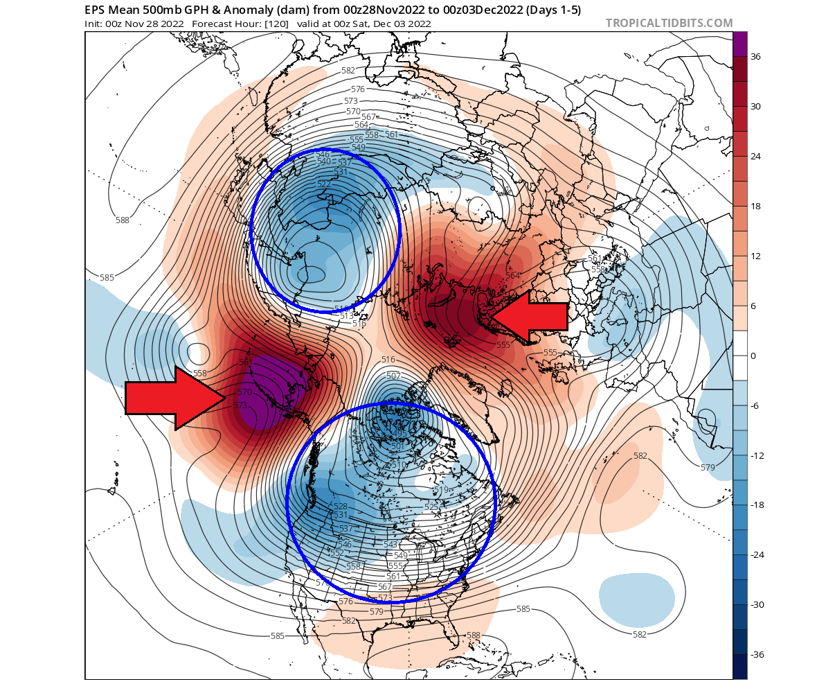
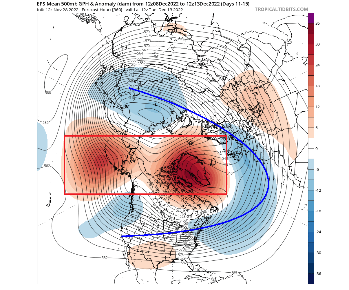
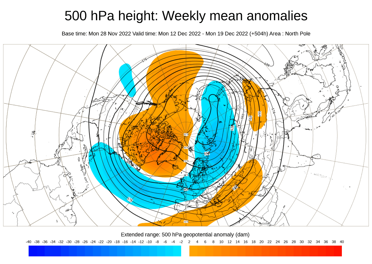
Going further into December, you can see in the forecast below that a new ridging is developing over the North Atlantic/Greenland area. Again, strong anomalies will quickly develop a blocking high, further disrupting the circulation and breaking down the usual low-pressure circulation into 3 main zones.
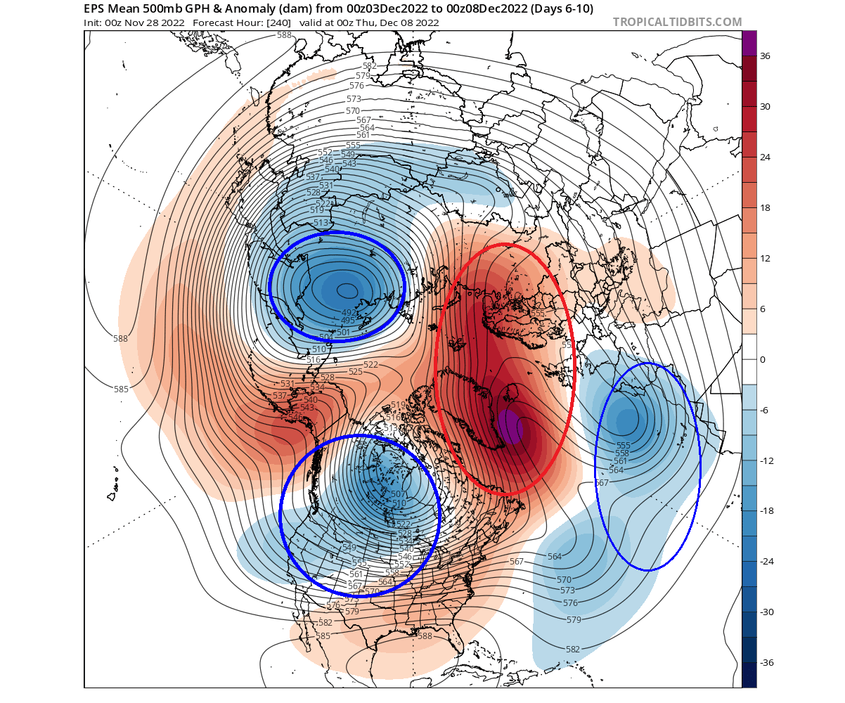
Looking at the raw geopotential height, you can see just how strongly the Greenland blocking-high pushes into the polar circulation. It transports warmer air along, displacing cold air out into northern Europe and the northern United States.
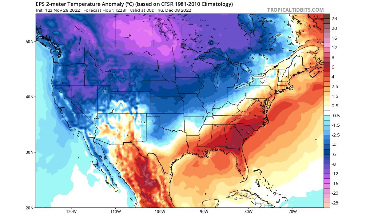
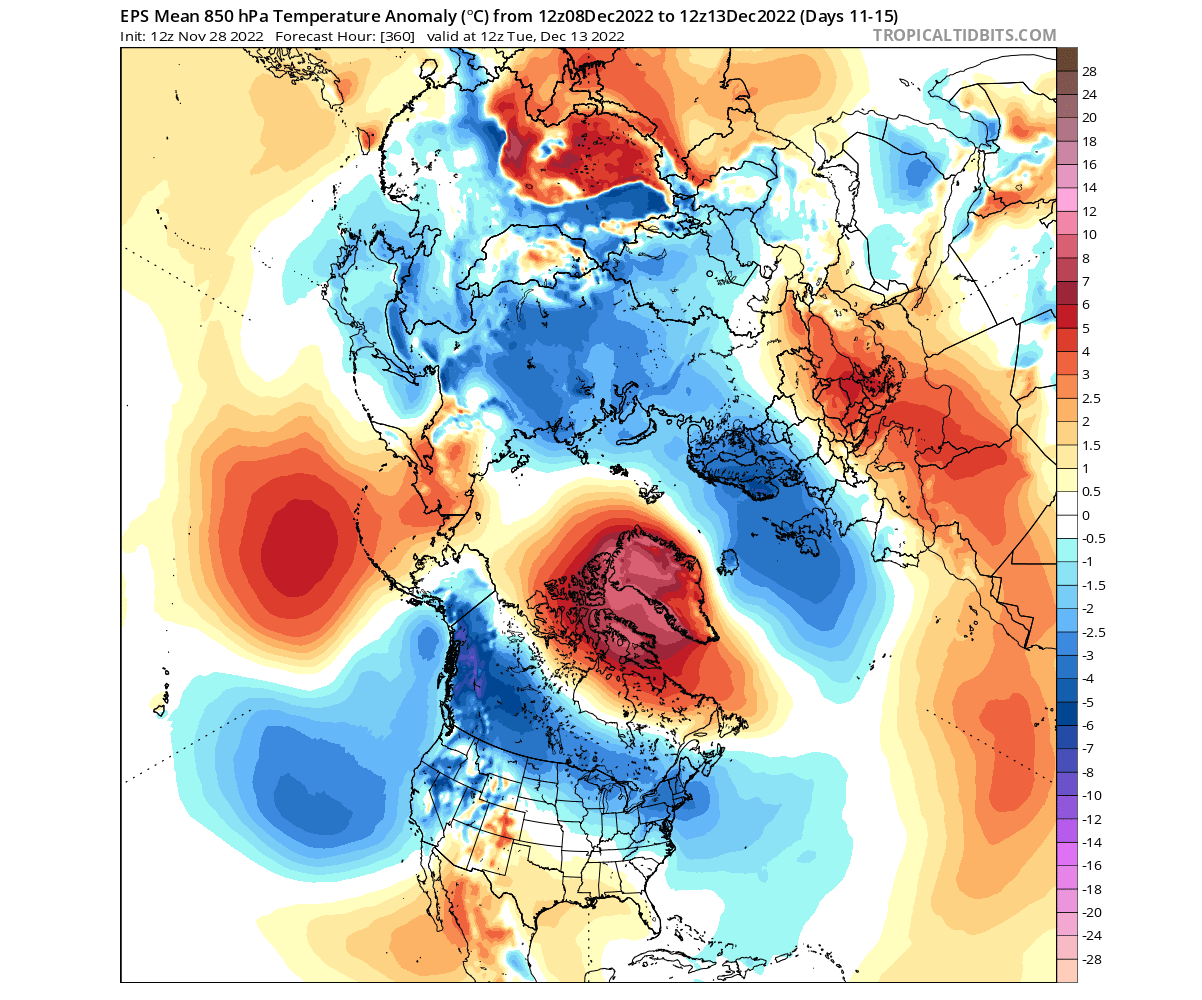
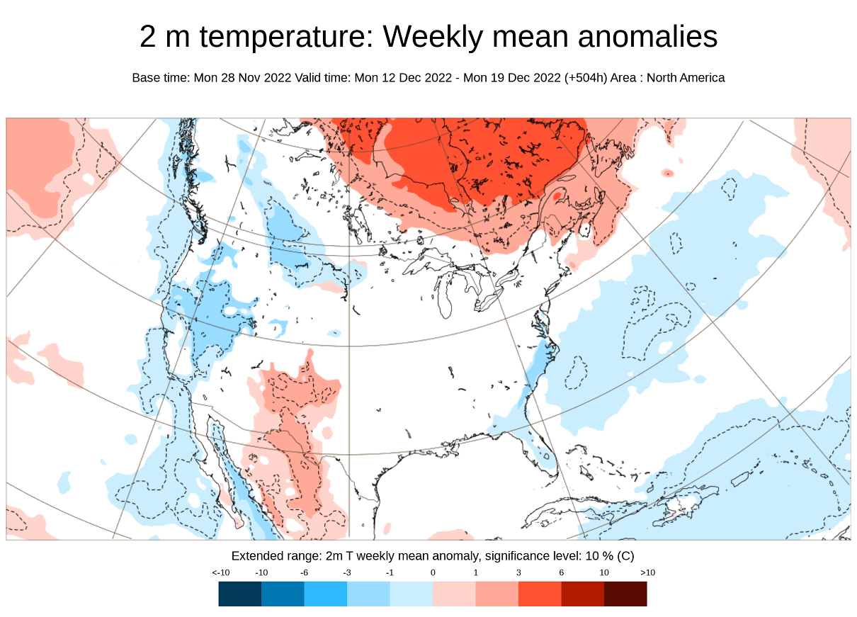
You can see that even better in the temperature anomaly pattern, with warm anomalies rising into Greenland. Colder air is forecast over northern Europe, with strong cold air pooling over western Canada and the northern United States.
Looking closer at the cold air over North America, the forecast shows another cold air wave spreading across much of the central and northern United States in this period. Warmer than normal weather will prevail over the southeast and up the east coast.
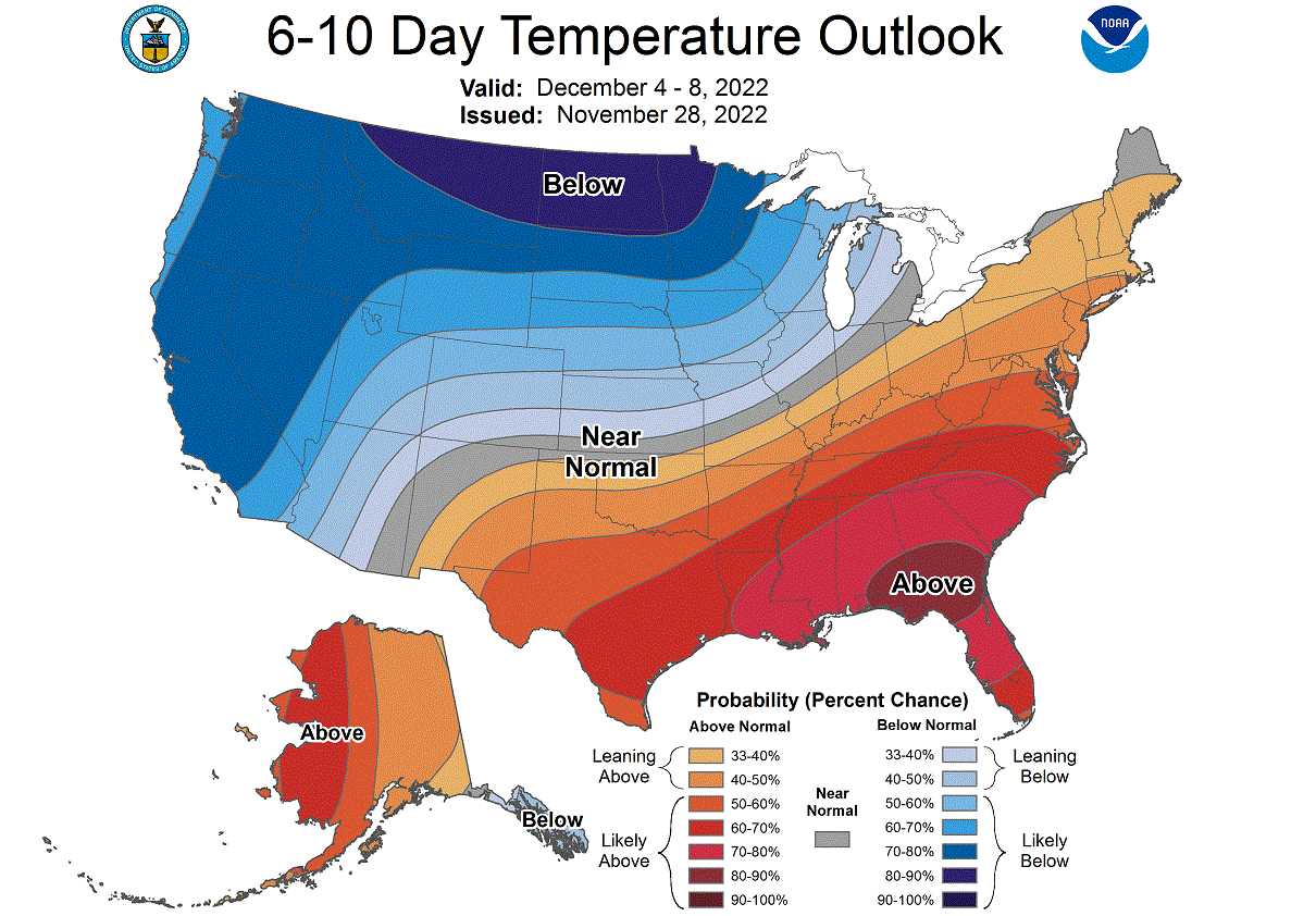
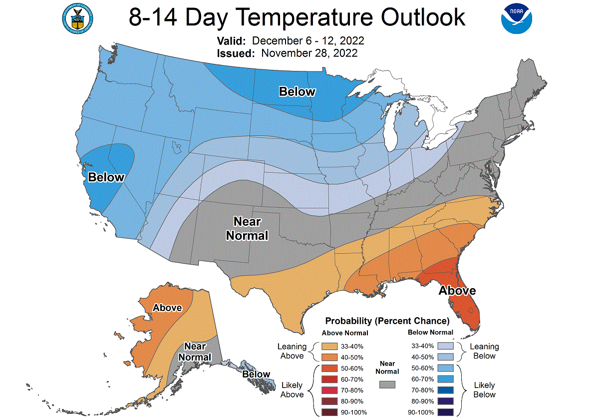
NOAA also regularly releases their 6-10 day forecast for the United States. Below we have the temperature outlook, forecasting a cold Winter start in the northwestern United States and the Midwest. The southern and eastern United States will have a temporary warmer-than-normal period.
We also have the precipitation forecast below, which calls for more precipitation over much of the United States in this period as weather systems progress across the country.

POLAR VORTEX SPLIT FORECAST
A rapid rise of the Greenland high will be felt far up into the Stratosphere. In the image below, you can see the vertical pressure anomalies over the mid-latitudes. Notice the positive pressure anomalies (red box) reaching upwards over Greenland and the North Pacific. And the separated low-pressure core of the Polar Vortex (blue box).
This upward push can also be tracked in the heat flux graph for the lower Stratosphere. You can see a peak of vertical thermal energy transfer in this period as the new blocking high over Greenland rises to power.
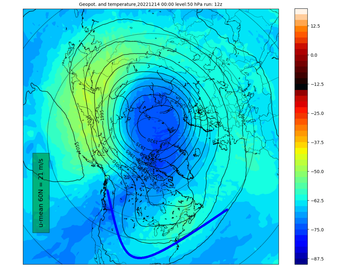
Looking at the actual map for the lower Stratosphere, you can see a noticeable compression of the Polar Vortex from both the Pacific and the Atlantic sides. It effectively separates the Polar Vortex into two individual entities, creating a proper core split.
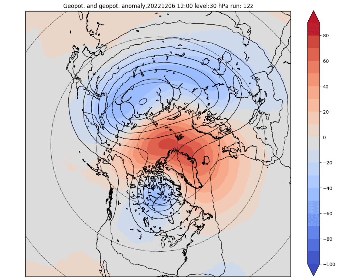
Looking at the pressure anomalies a bit higher up in the mid-stratosphere, you can still see the strong high-pressure anomalies over the Greenland/Polar regions. This is a direct upward reflection of the strong high-pressure anomalies and the lower circulation disruption.
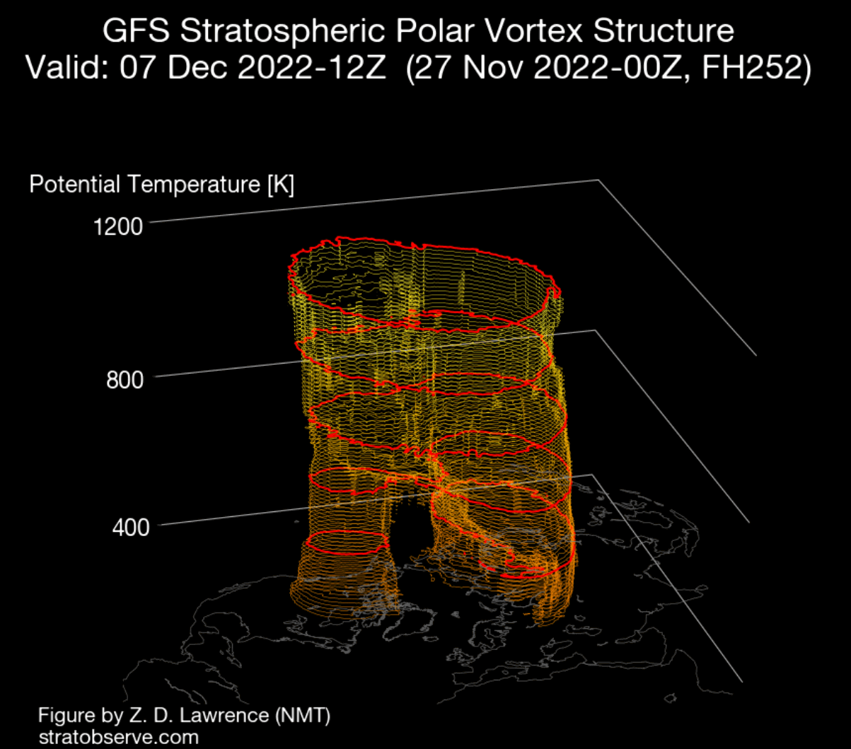
This is best seen in the 3D structure display. As you can see in the image below, the entire lower part of the Polar Vortex has split apart as the high-pressure blocking systems separate the cores.
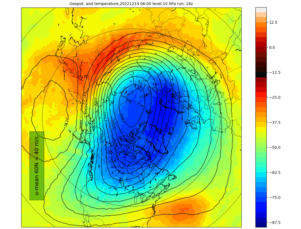
The core separation can still be seen going a bit higher up into the mid-stratosphere at 30km/18.5miles. But the effect of the high-pressure systems from below starts to wear off and is hard to sustain from below for a long period and into high altitudes.
But the lower blocking pattern will remain and is likely to play a more long-term role for the stratospheric Polar Vortex rather than an immediate one.
MID-DECEMBER WEATHER BREAKDOWN
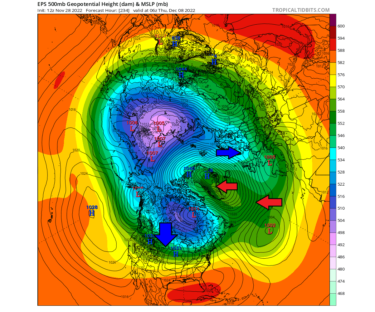
Going into mid-month, the ensemble forecast calls for a strong and stable Greenland block, paired with a semi-permanent North Pacific high, the courtesy of the Pacific La Nina. The low-pressure zones will be placed across the mid-latitudes, creating an almost reversed weather pattern.
The temperature anomaly forecast shows the reverse pattern, with warmer-than-normal temperatures over the polar regions. This way, the cold air gets displaced out into the lower latitudes, as seen over northern Europe and across the northern and eastern United States.
Looking closer at the United States, the ensemble average shows another cold wave spreading over the Midwest and down into the eastern half of the United States. Having a high-pressure system over Greenland definitely supports a more northerly flow across the northern and eastern United States.
NOAA OFFICIAL WEATHER OUTLOOK
The official 8-14 day forecast from NOAA shows the colder temperatures prevailing over much of the northern and western United States. But individual events are likely to spread further over the eastern United States.
The precipitation forecast shows more precipitation, mainly over the far western United States and over the southeast. However, drier conditions are expected over the Great Lakes region.

POLAR VORTEX RECOVERY
Despite having a very disrupted low-level weather circulation, the upward pressure is expected to (at least temporarily) ease off. This will allow the lower stratospheric Polar Vortex to regain some composure but will remain elongated, reaching down into North America.
The forecast is the same for the mid-stratosphere, having an elongated and rather healthy Polar Vortex. But the next disruption is likely not far off, as we are monitoring a developing trend of possible warming events emerging in the Stratosphere later in the month.
Yet again, the 3D structure helps to reveal the shape of the Polar Vortex across the many levels of the atmosphere. It is still being split in the core at the lower levels, but the strong momentum from above will (temporarily) reshape the structure and merge the cores back in higher altitudes.

EXTENDED WEATHER FORECAST
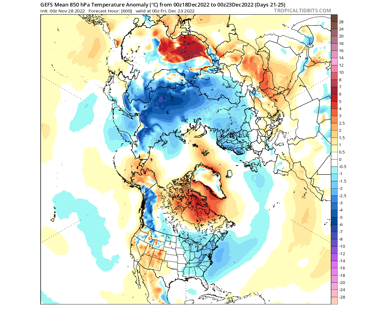
Looking further into the second half of December, we will use the extended ensemble forecast from the ECMWF and the GEFS.
The ECMWF pressure pattern forecast shows continued high-pressure blocking over the Greenland area, extending into eastern Canada. A zone of low-pressure anomalies thus extends from the eastern United States across the North Atlantic into Europe.
The temperature forecast for Europe shows warm anomalies over much of the central and southern half. Colder air is forecast to remain in the more northern parts, but a pattern variation can quickly extend a cold wave down into central Europe, not seen in the extended range average.

The temperature forecast for North America shows colder air to persist in the western and northwestern United States. Some cold anomalies can even be seen in the southeast. But despite lacking real patterns at this range, we also don’t see any strong warm anomalies developing.
The GEFS for the second half of December shows the same trend as the ECMWF. Continued high-pressure blocking over the Greenland area, with two main low-pressure zones over Siberia and the eastern United States.
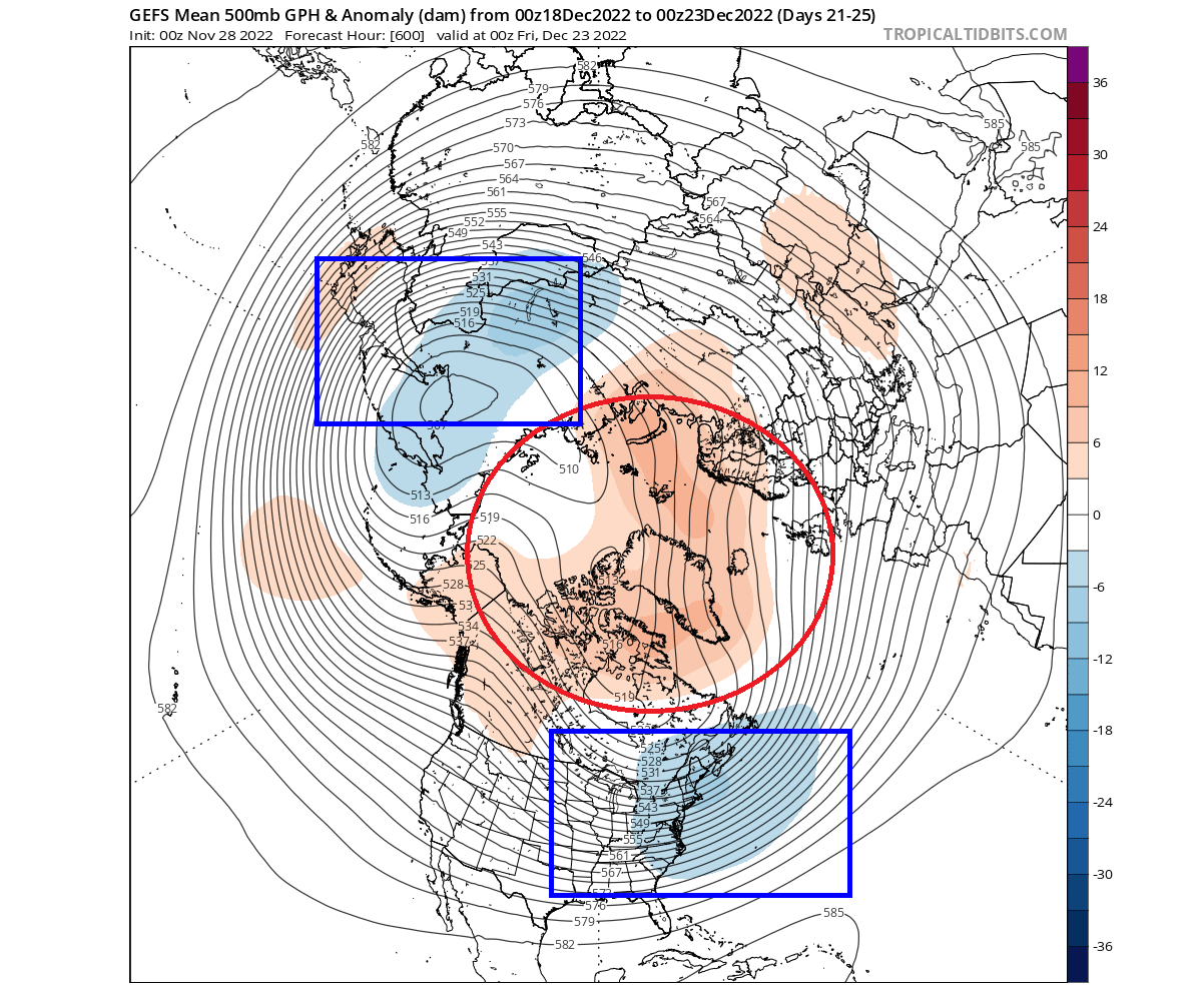
The temperature forecast in this extended range shows the warm anomalies close to and around the Arctic circle. As a response, the colder air is displaced, most notably in northern Europe and over the northwestern and eastern United States.
But as we have mentioned in the background processes, one event can still result from these dynamics in the long run.
STRATOSPHERIC WARMING EVENT
A Sudden Stratospheric Warming event (SSW) is a rapid rise in stratospheric temperatures and can significantly impact the circulation and pressure patterns in the Northern Hemisphere. It produces a strong stratospheric disruption and eventual surface weather changes.
One such event occurred in early January 2021. The stratospheric warming wave has spread over the entire North Pole in the Stratosphere, effectively splitting the cold core of the polar Vortex into two parts. The difference to the current upcoming split is that a proper SSW event breaks down the entire Polar Vortex, not just the lower parts.
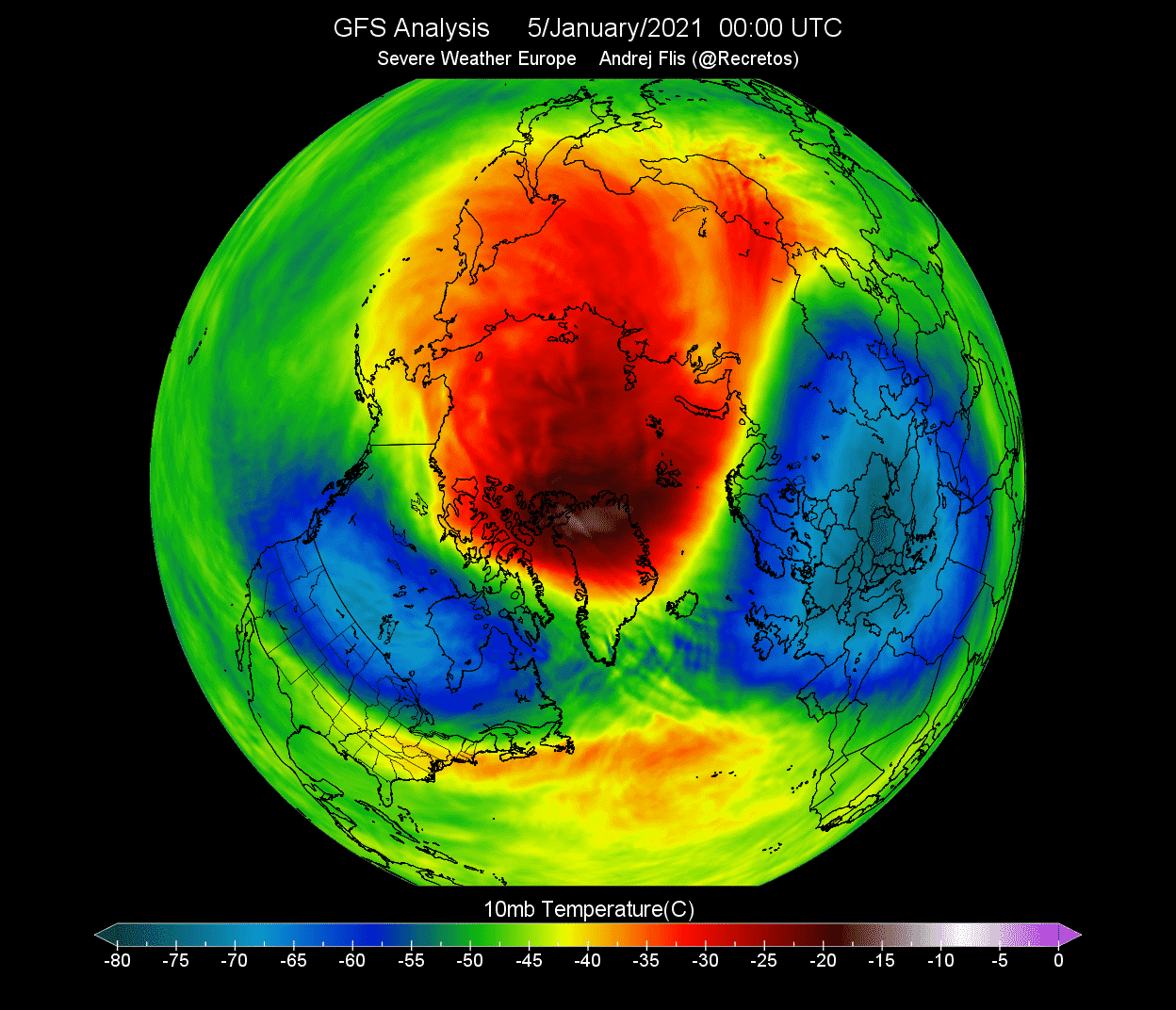
In 2021, one part of the broken polar Vortex moved over North America, and one remained over the European area. At this point, this did not yet influence the winter weather on the surface, as such events begin at over 30km (18 miles) altitude. But the weather influence followed downwards quite soon after.
That is how a stratospheric warming event typically operates. First, it breaks down the upper structure of the Polar Vortex, which then collapses downwards, impacting the weather at the surface.
Below is an image that shows an average temperature pattern 0-30 days after a proper winter stratospheric warming event. High pressure over the Arctic helps unlock the cold air out of the Arctic regions, sending it deeper into the mid-latitudes of the United States and Europe.

Looking at the snowfall below, we can see above-average snowfall over much of the eastern United States and Europe after a Polar Vortex collapse event. But, again, this is an average response, as the colder air has an easier path towards the south and into these regions after a stratospheric warming event.
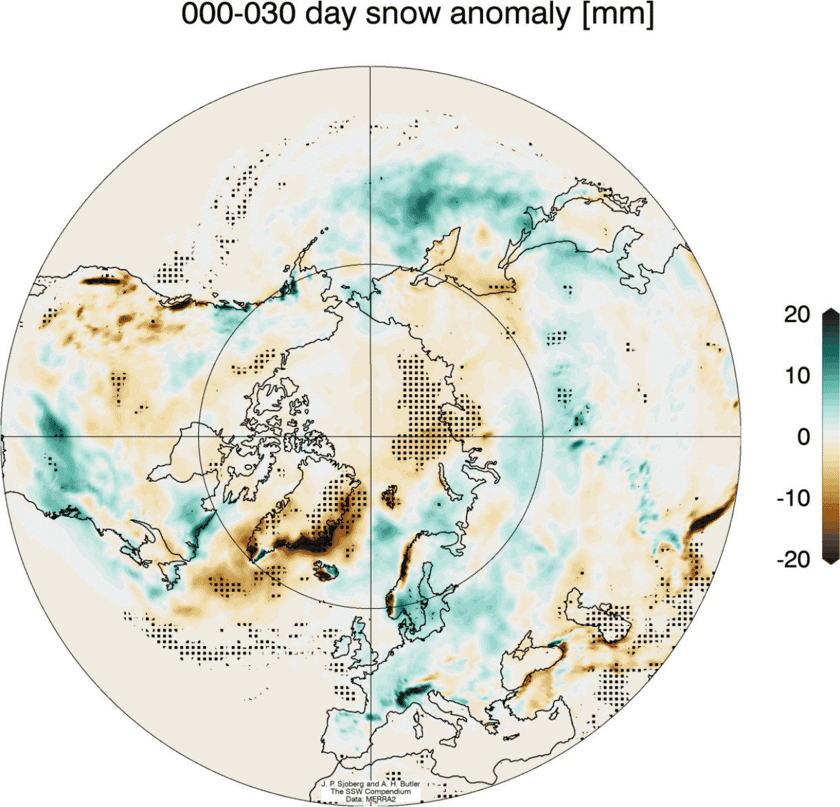
Of course, not every stratospheric warming event produces this pattern, but it helps to show us an average image of many events in the past 40 years. A lot depends on the already-established weather patterns at the lower levels of the atmosphere.
These dynamics can have a large-scale and long-lasting impact on the weather pattern during Winter, so we continually monitor the stratospheric development.
We will release weekly and monthly updates during the winter season as fresh forecasts and data are available. So make sure to bookmark our page. Also, if you have seen this article in the Google App (Discover) feed, click the like button (♥) there to see more of our forecasts and our latest articles on weather and nature in general.
SEE ALSO: