A deep low-pressure area will form over parts of the UK on Wednesday night into Thursday, with potentially significant wind impact and heavy rain. Travel disruption and damage could result from the low with gusts up to near 120 km/h across the southern UK towards the northeast of France and the Benelux coast on Thursday morning.
According to the latest weather model guidance, an upper wave digs into western Europe midday Wednesday, resulting in a surface low forming over the Bay of Biscay. The low then undergoes rapid intensification* from 988 mbar to 961 mbar by Thursday 12 UTC.
*Note: The rapid intensification of a surface low means that the central pressure significantly deepens, with a rate of more than 24 mbar pressure drop over a 24-hour period.
The Met Office issued this great graphic of possible scenarios regarding the low-pressure area track from Wednesday afternoon through Thursday midday. The most likely scenario, also supported by the majority of the weather models, brings the low across the English Channel. While the less likely scenario tracks it across southern England towards the North Sea.

Here is a video animation of the system developing over the Bay of Biscay on Wednesday, and undergoing a rapid intensification on Wednesday night into Thursday as it tracks along the southern England coast into the North Sea.
We can see the central pressure rapidly deepens with time, dropping from around 988 mbar on Wednesday, 12 UTC, to near 961 mbar by Thursday, 12 UTC. This is a 27 mbar pressure drop within a period of 24 hours, which equals a rapid intensification and a so-called bombogenesis process of the low-pressure area.
The video includes several weather model comparisons regarding the potential track of the low.
Let’s dig into the evolution of the potentially significant impact of this deep low for southern England and the coast of northern France, Belgium, and the Netherlands, Wednesday night through Thursday.
Deep wave emerges into Western Europe, leading to a rapidly intensifying surface low on Wednesday
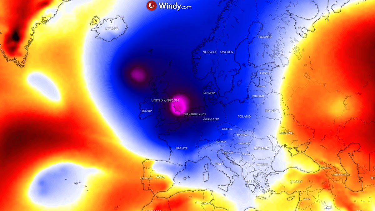
The general weather pattern over the North Atlantic and Europe indicates a deep upper wave emerging into Western Europe Wednesday night into Thursday morning, with a significantly deep core. To the south, a blocking High is located over northwestern Africa and southwestern Europe, allowing the wave to graze east into the European continent.

By Wednesday midday, a surface low forms over the Bay of Biscay, underneath the deep core aloft. As a colder air mass arrives in the upper levels, the surface low undergoes rapid intensification while it tracks towards the English Channel and southern England.
Around midnight Thursday, the low will already deepen to near 975 mbar, with a 13-14 mbar drop over the 12-hour period. The low also grows big in size overnight.

By Thursday 12 UTC, the low reaches its peak as it tracks very near the southeastern tip of England and over the English Channel. The central pressure will drop for another 12-14 mbar, reaching its bottom around 960-962 mbar.
This is a 26-28 mbar pressure drop in a 24-hour period, a textbook example of the rapidly developing low, a bomb cyclone. The wind field will intensify.

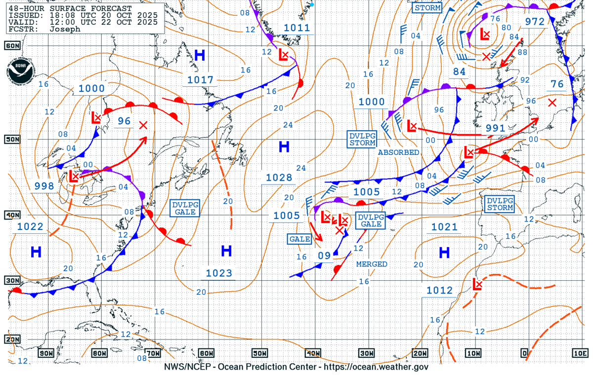
The following surface forecast by NOAA Ocean Prediction Center also hints that the low will be tracking along the coast of southern England. This means that the area could experience severe winds.
The deep low will be part of the overall dynamic activity over the European part of the North Atlantic, with another low near the Azores. But this one will not track towards the UK.
The complex, large cyclone will remain over Ireland, the UK, and the North Sea until Friday. It will also separate the temperature picture across Europe.
Above normal temperature weather will spread across most of the continent, while cold maritime air mass will gradually spread into Western Europe on Thursday, before it continues with the refreshment towards central Europe on Friday.
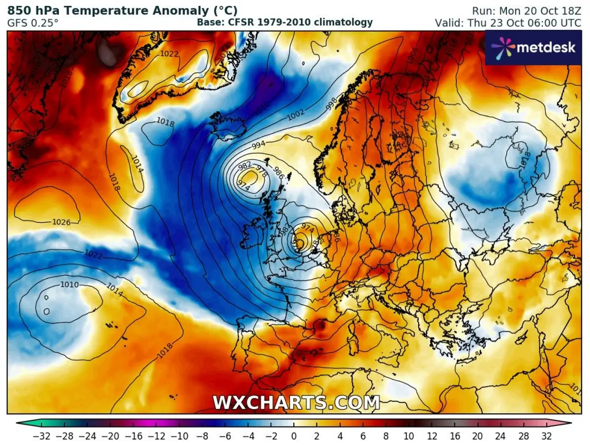
As the colder air and the main large wave/low arrives towards the Alpine region, it also triggers a secondary Lee low over the Northern Mediterranean and brings a potent front with heavy precipitation into the region on Thursday night.
Rapid intensification of the low-pressure area brings severe winds on early Thursday
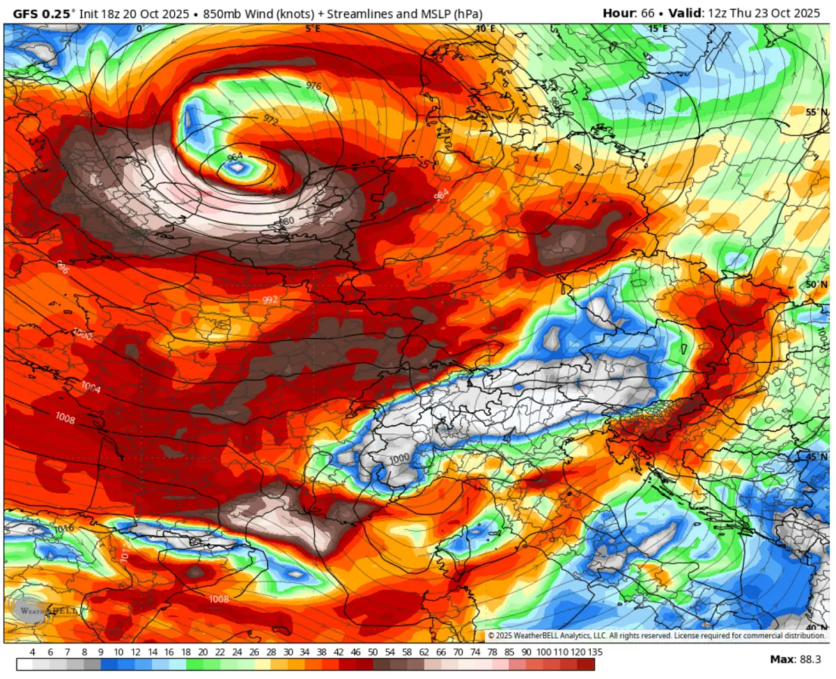
So, the surface low-pressure area with a frontal system forms on Wednesday afternoon, tracks northeast on Wednesday night while rapidly intensifying. A bombogenesis takes place over the English Channel. The low reaches its peak pressure around 961 mbar by Thursday midday.

The rapid intensification of the low significantly increases the wind field in response to a strong pressure gradient across the southern UK, the English Channel, France, and the Bay of Biscay.
At the lowest levels, the average wind speed reaches around 85-90 knots (150-170 km/h) at 850 mbar, approximately 1200 meters above the sea level.
This is a pretty significant wind and will disrupt airfare traffic from Thursday morning through the afternoon hours.
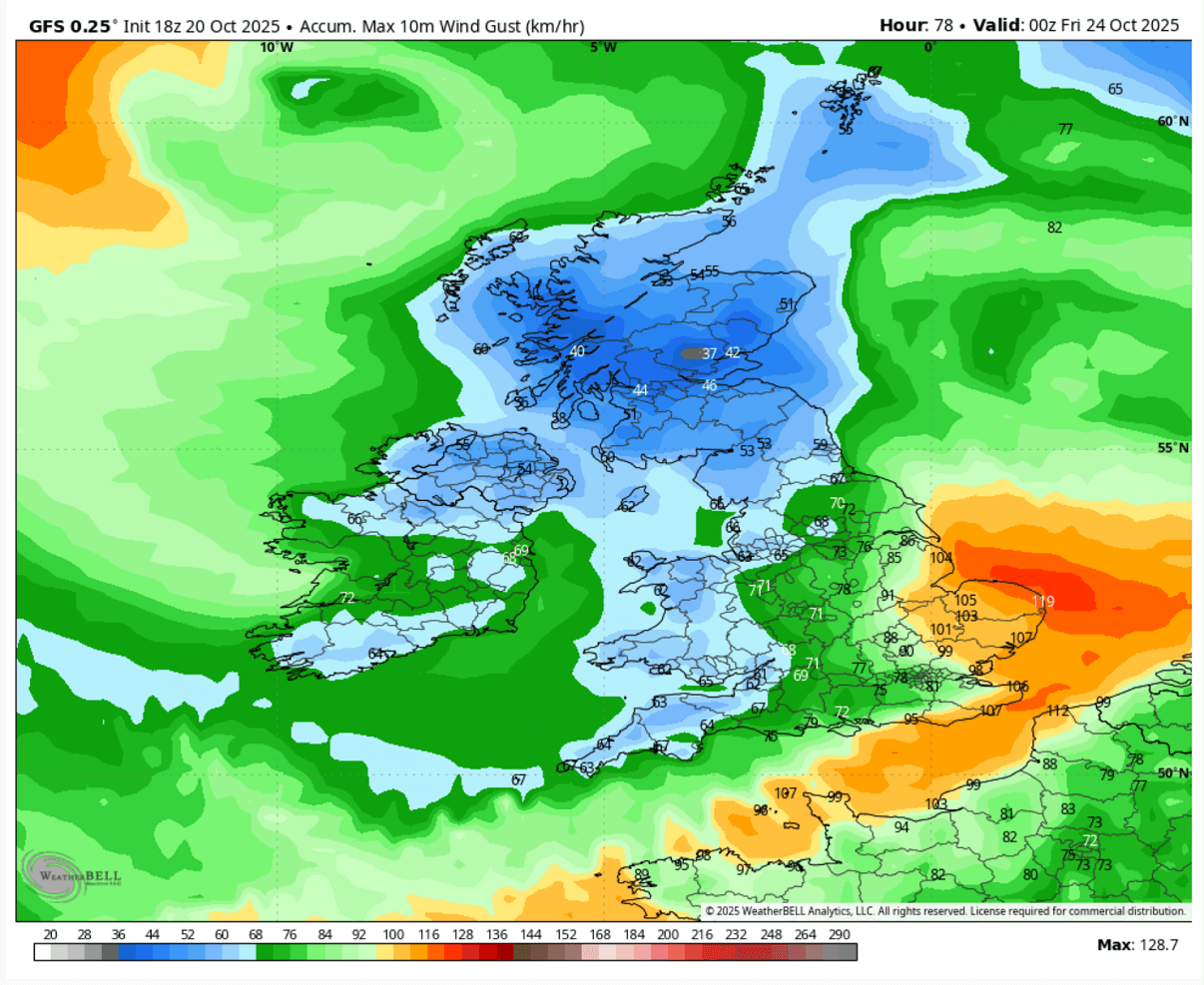
At the surface, this wind field translates into strong to severe wind gusts, potentially reaching 100 to 130 km/h, from the northern coast of France across the English Channel, the southern England coast to the southern North Sea coastal area of Belgium and the Netherlands.
This is based on the most likely scenario regarding the track of the deep low, which travels along the coast of England. The following chart represents the swath where the winds will be the most intense from Wednesday night through Thursday midday.
The deep low-pressure area will also dump quite some rain along its path from the Bay of Biscay across southern England to the North Sea.
The most likely scenario delivers around 60 to 80 mm of rain within 12-24 hours of the cyclone’s travel time. Therefore, the short period of excessive rainfall could lead to some local flooding.

Some thunderstorms will also be possible, especially along the main front as it travels across the English Channel on Wednesday night.
Stay alert for the potential significant impact of this bomb cyclone on Thursday.
Wxcharts and WeatherBell provided images for this article.
See also: