A Sudden Stratospheric Warming event has begun, starting one of the earliest collapse events of the Polar Vortex. The latest forecasts show this collapse from the stratospheric warming impacting the lower levels, bringing cold weather and snowfall to certain areas across the United States and Canada, and Europe.
A strong Polar Vortex locks the cold air into the polar regions, creating a mild winter. But when the Polar Vortex is disrupted or collapsed, the cold air can escape, unleashing proper winter weather in the mid-latitudes.
In this article, we will look at the latest stratospheric warming data and the collapsing Polar Vortex. You will see how these stratospheric events will release cold and snow across the United States, Canada, and also Europe, creating a significant pattern change in December and (as currently forecast) also snowfall for the holidays.
THE COLD POLAR VORTEX
To understand what the Polar Vortex is and how it works in a simple way, you don’t need to be a weather expert.
You can simply imagine the Polar Vortex as a large low-pressure area, acting like a spinning “wall” over and around the polar regions from the surface to the stratosphere (over 50km/30miles high), containing the cold polar air inside.
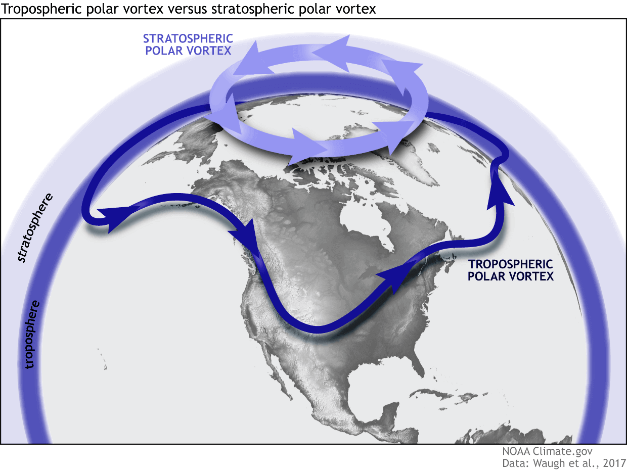
For this reason, we separate the entire Polar Vortex into an upper (stratospheric) and a lower (tropospheric) part. They both play their role differently, so we monitor them as two separate systems. But together, the two parts form the whole winter circulation and shape our daily weather at the surface.
We closely monitor the strength, shape, and size of the Polar Vortex, and separate it into two main “modes”:
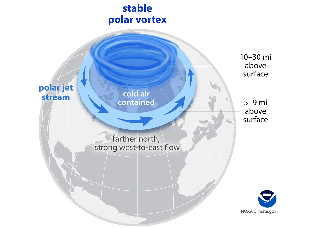
A strong (stable) Polar Vortex means a strong polar circulation. This locks the colder air into the polar regions, preventing its escape. As a result, this creates milder winter conditions for most of the United States, Europe, and other mid-latitudes.
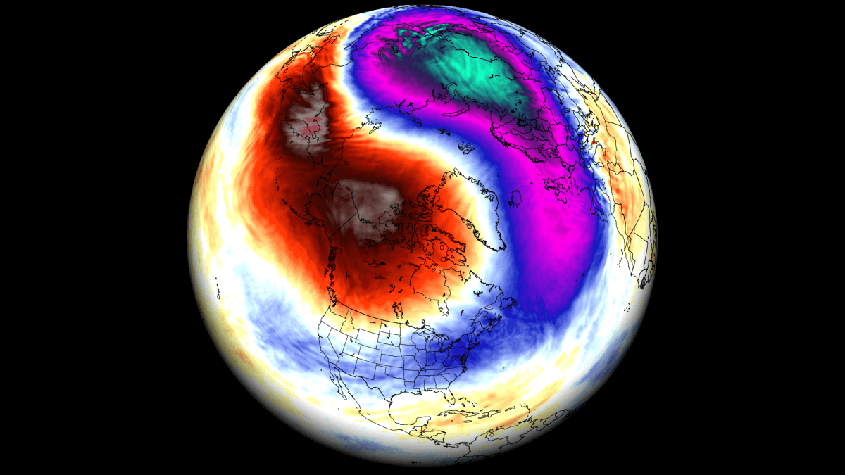
The second mode is a full Polar Vortex collapse. A disrupted Polar Vortex has a much harder time containing the cold air, which can now easily escape from the polar regions into the United States and other mid-latitude regions. Below is an example of how a disrupted Polar Vortex helps to release the cold polar air into the United States and Europe. Both images are by NOAA-Climate.
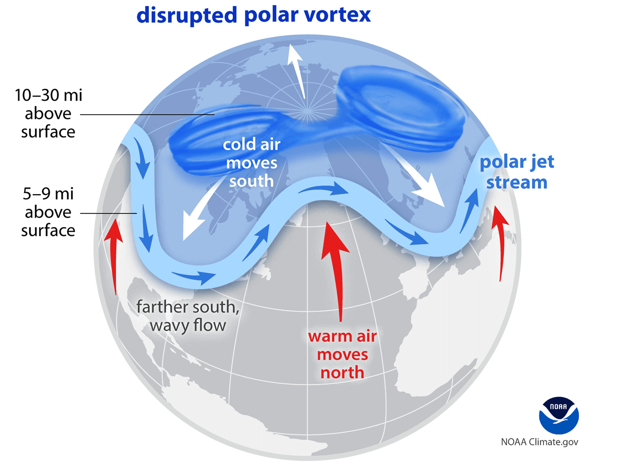
If you want proper Winter weather with cold and snow, a weak/disrupted Polar Vortex is exactly what you want to see, increasing your chances for a proper cold winter season.
For the best idea of what the Polar Vortex is, we produced a high-resolution video below. It shows the Polar Vortex in true 3D, giving you the best possible presentation of what it actually looks like if you were ever able to see it. Video shows the Polar Vortex forecast and the start of its disruption.
The main takeaway from the video should be that the Polar Vortex is a single large circulation, connected through the atmosphere. So, for example, it’s not just one winter storm across the northeastern United States.
We will now look at the latest analysis of the Stratospheric Warming event and how it is already affecting the Polar Vortex.
STRATOSPHERIC WARMING EVENT IN PROGRESS
The latest analysis below is for mid-stratosphere (30km/18.5miles height) shows that the Polar Vortex is already starting to deform. It should usually have a nice circular shape, but you can see how a high-pressure area is pushing it out and changing its structure. The temperatures are also rising in the area around the cold core. Image by weatheriscool.com
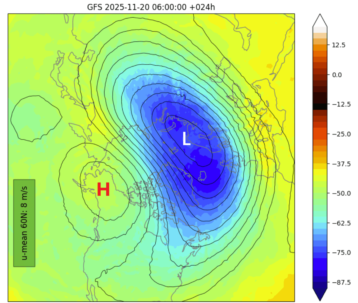
Typically, the cold core of the Polar Vortex should cover a large area, centered over the North Pole. But as the entire Polar Vortex mass is being displaced, temperatures are much higher than normal over the polar regions.
In the image below, you can see the pressure anomaly at the same level in the stratosphere, which shows that the main core of the Polar Vortex is running with normal low pressure. But here you can better see the developing high-pressure anomaly in the stratosphere, which is causing a great deal of trouble for the Polar Vortex.
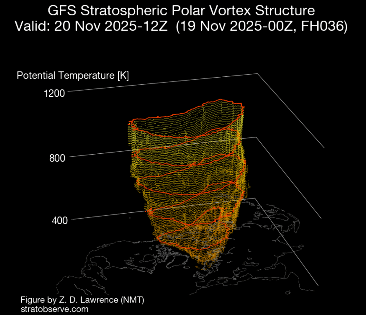
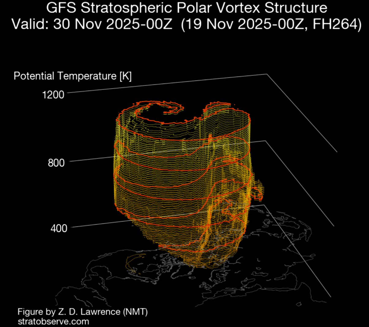
If we look at the 3D analysis of the Polar Vortex below, you can see its full structure and how its mass is getting deformed. This is only the beginning of the Polar Vortex disruption, as the high-pressure and higher temperatures are forecast to push deeper into its structure and reduce its strength.
But how do we actually measure the strength of the Polar Vortex? The simple answer is that we look at the winds it produces. The more organized the stratospheric Polar Vortex is, the stronger the winds around its core.
Below is the latest analysis and forecast of the stratospheric winds and temperature around the Polar Vortex. You can see that all forecasts indicate a significant weakening of the Polar Vortex over the next two weeks, as the high-pressure area expands in the stratosphere and temperatures rise with stratospheric warming.
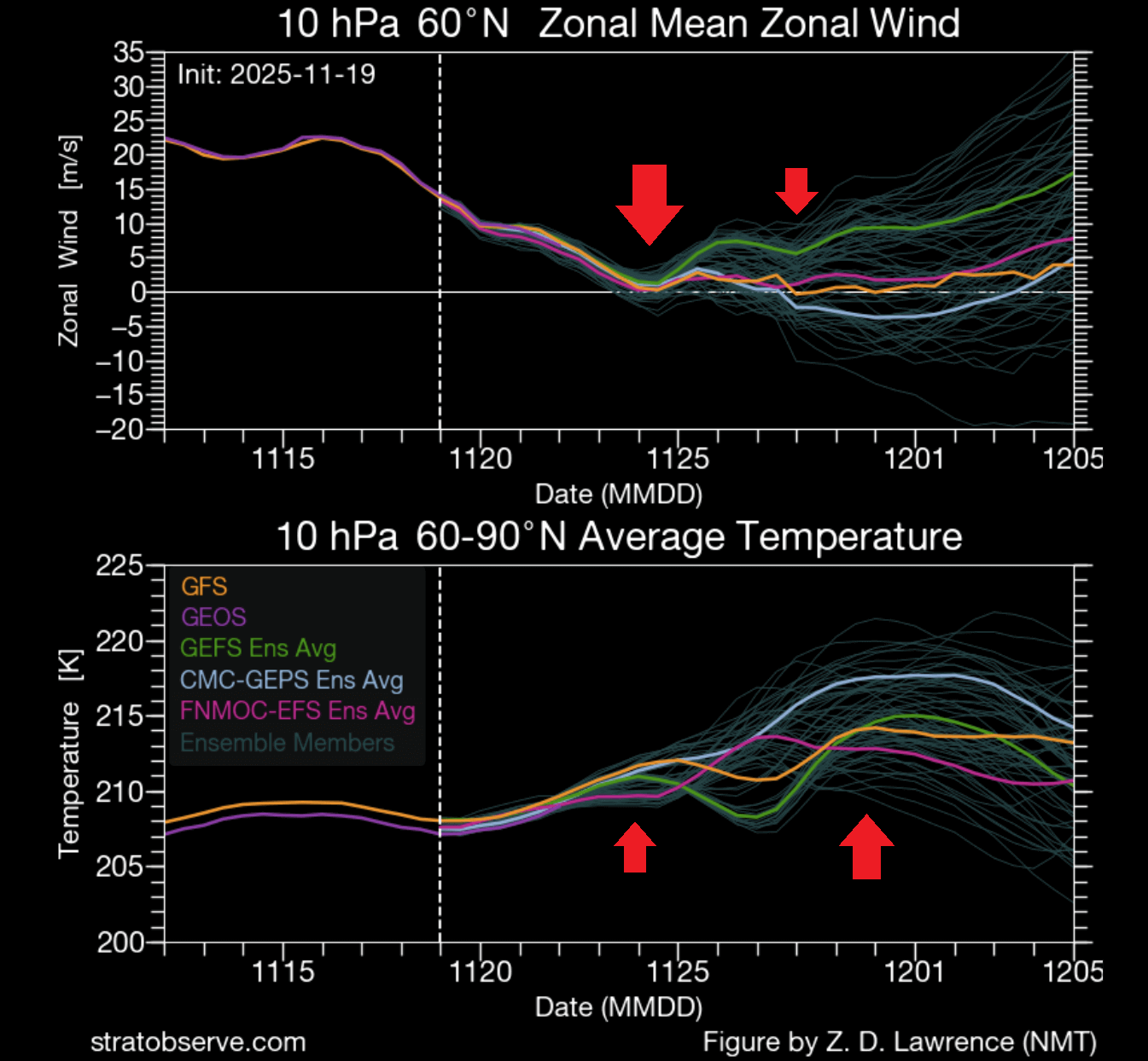
An important wind threshold is the 0 line, which marks a wind reversal in the stratosphere from the usual westerly to the easterly. A reversal would mark this event as a major Sudden Stratospheric Warming (SSW). But surface weather impacts can also occur without a wind reversal if the Polar Vortex is disrupted enough. Image above by stratobserve
Below is a typical schematic of how a stratospheric warming event works. The image shows pressure anomalies across the atmosphere over the whole SSW event. You can see how the main event in the stratosphere affects the surface layers downwards over a certain time period. We are currently around day -5 to -7.
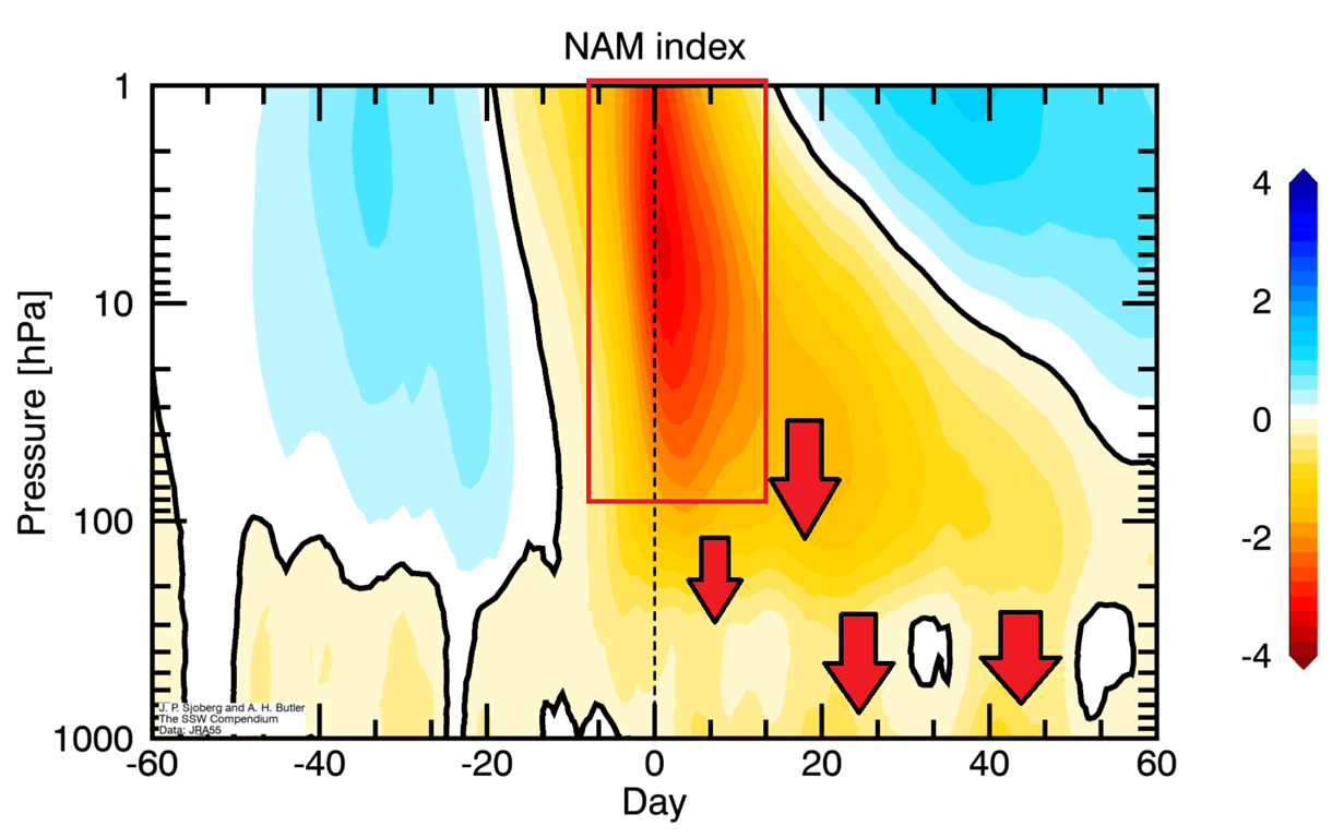
This energy disrupts the Polar Vortex by creating areas of higher temperature and pressure in the stratosphere. The top-down collapse of the Polar Vortex then allows cold air to escape the polar regions and cover the United States and/or Europe.
Peak Polar Vortex disruption is currently forecast around Thanksgiving, and it is expected to mark the start of a strong weather pattern change as we head into meteorological winter.
POLAR VORTEX DISRUPTION FORECAST
The graph above also shows us that any major weather impacts from this stratospheric warming event are still 2-3 weeks away, aiming for early December.
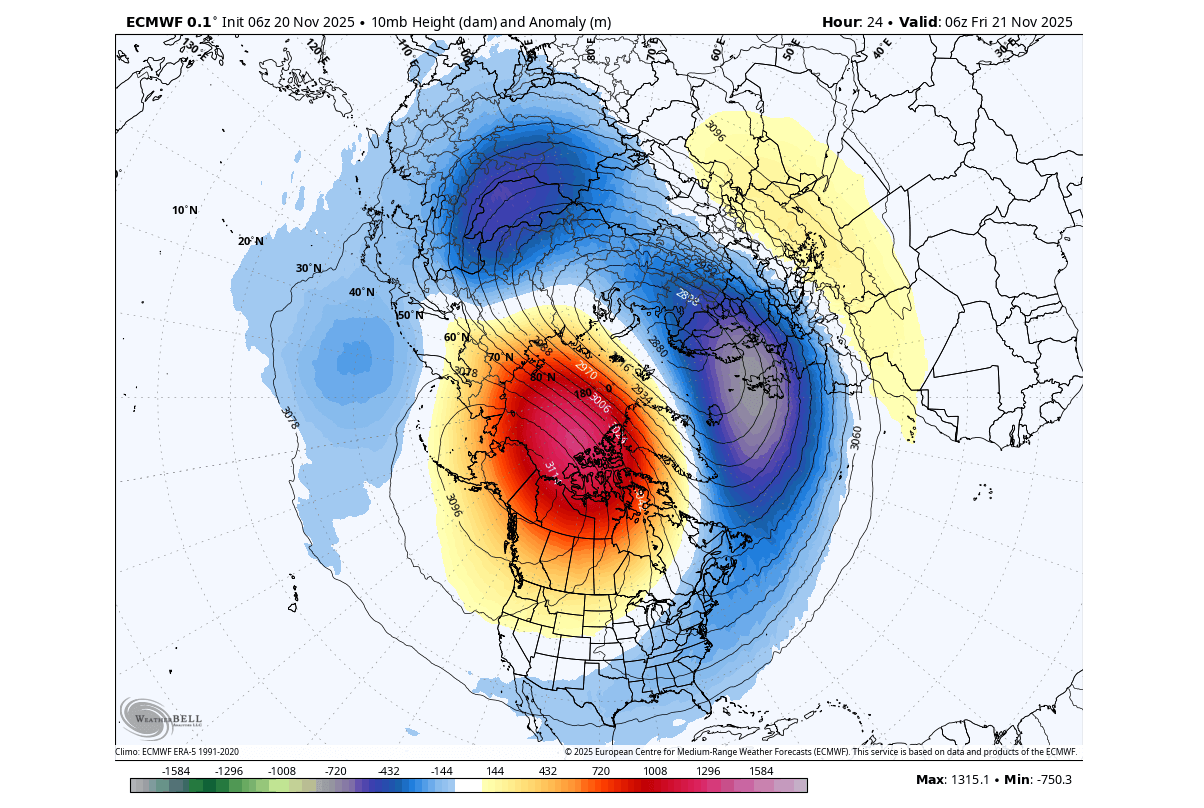
The latest forecasts show the peak warming/disruption to occur later this month, around the 25th, give or take a day or two. In the image below, you can see a very strong high-pressure area in the mid-stratosphere, sometimes called the “anti-vortex” due to its size.
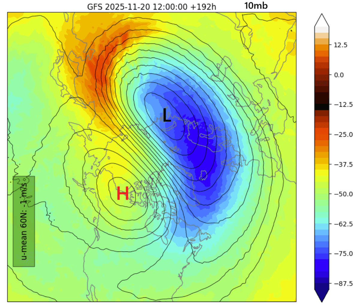
You can see a very strong warming wave occurring where they come together, deforming and disrupting the Polar Vortex, aided by the surrounding temperature waves
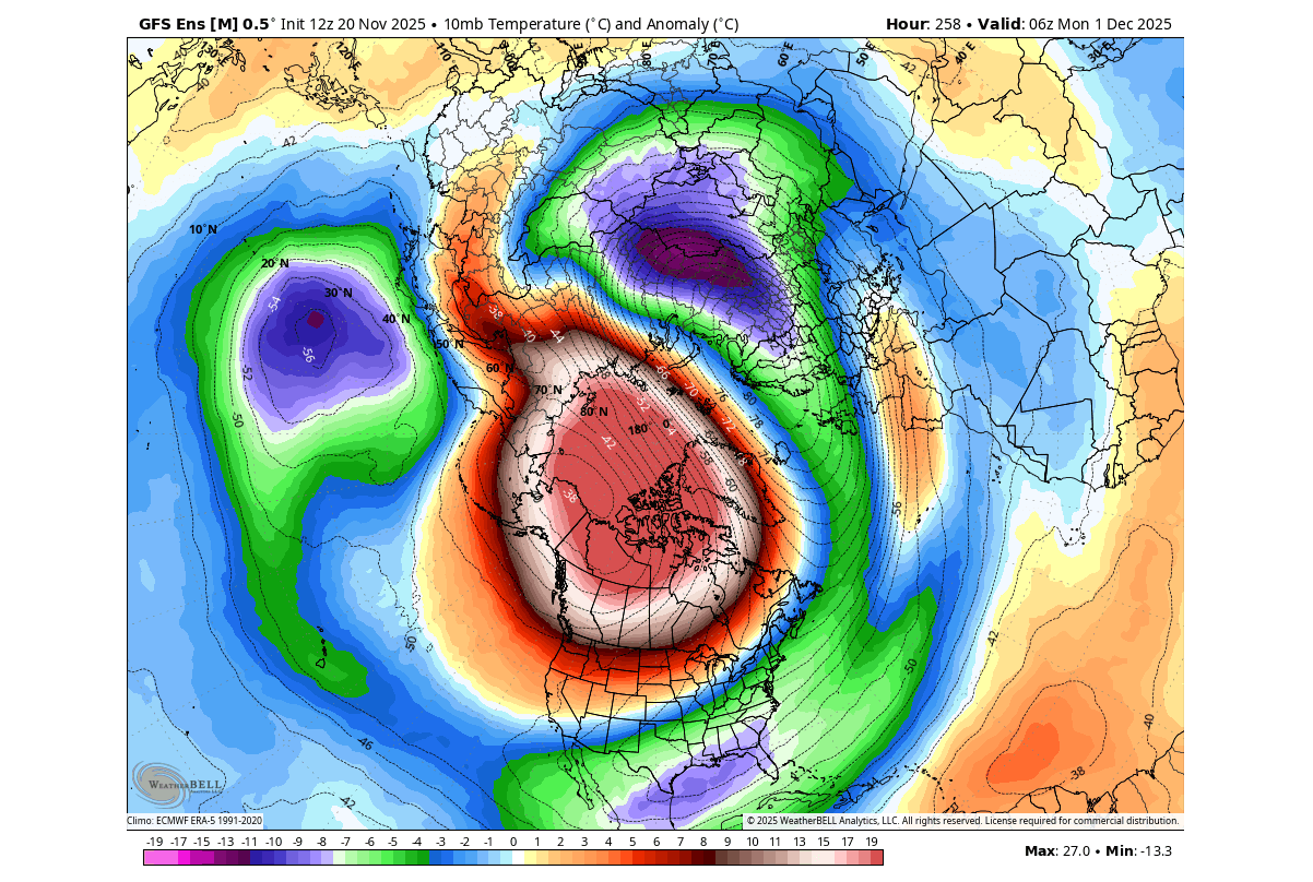
The true extent of the stratospheric warming event (SSW) can be seen in the latest temperature anomaly forecast for the same level. Below, you can see a strong warming anomaly, with the temperatures in the mid-stratosphere nearing 30 degrees C above normal. This nicely shows the intensity of the SSW event, creating a warm anomaly where it actually reverses the stratospheric winds.
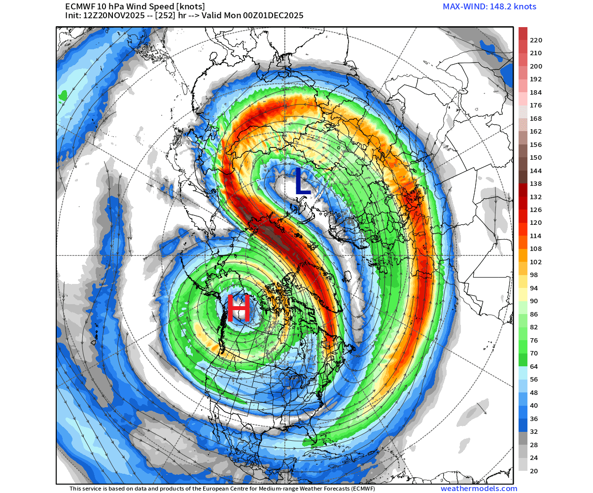
Overall, this is quite a strong event, as it was visible interactions between the Polar Vortex and the high-pressure system. We can see that easily in the wind field forecast below, which shows the stratospheric winds. Note the deformed structure and how the smaller anti-cyclone is draining energy from the Polar Vortex.
Below is also a 3D forecast of the Polar Vortex for the end of the month. You can clearly see a very disrupted structure and a deformed core, and a more obvious “power drain” over the whole structure. While these are just stratospheric parts, they do have an impact on the lower levels, but it can take some time
But speaking of lower levels: how will this event impact the weather at the surface? To answer that, we first need to find signs of some actual progress downwards from the stratosphere.
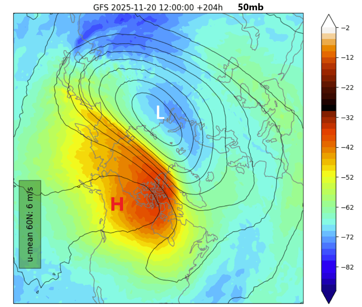
In the forecast graphic below, you can see the pressure and temperature forecast for the lower stratosphere at 50mb (20km/12.4miles), around the 28th. It shows a high-pressure area with a strong warming anomaly and a clearly displaced Polar Vortex. This is a clear sign of this event having a rapid downward response.
But if we go even lower down, or look at the much deeper layer (even better), we can use the pressure anomaly graph for the lower 50km/30miles of the atmosphere. This nicely shows us what the progress/movement is of the pressure anomalies through the atmosphere.
Below you can see the marked blue area, which has a clear upward progress, and marks the high-pressure wave energy going into the stratosphere. This is the trigger for the stratospheric warming event, which you can also see in the red box, along with the slow downward connection of the high-pressure areas.
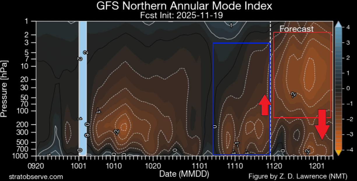
This tells us that the stratospheric disruption is strong, and we are also seeing the first direct signs of a connection between the stratosphere and the lower levels.
These warming events are known for having an impact all the way down to the surface levels. We can look at past events to get an idea of what to expect from such strong atmospheric events.
SURFACE WEATHER CHANGES
Below is the surface pressure pattern 0-30 days after a stratospheric warming event. This is a combined image of several past SSW events, so it gives us an idea of the impacts we can usually expect at the surface. You can see the high-pressure area over the pole, displacing the low-pressure areas around.
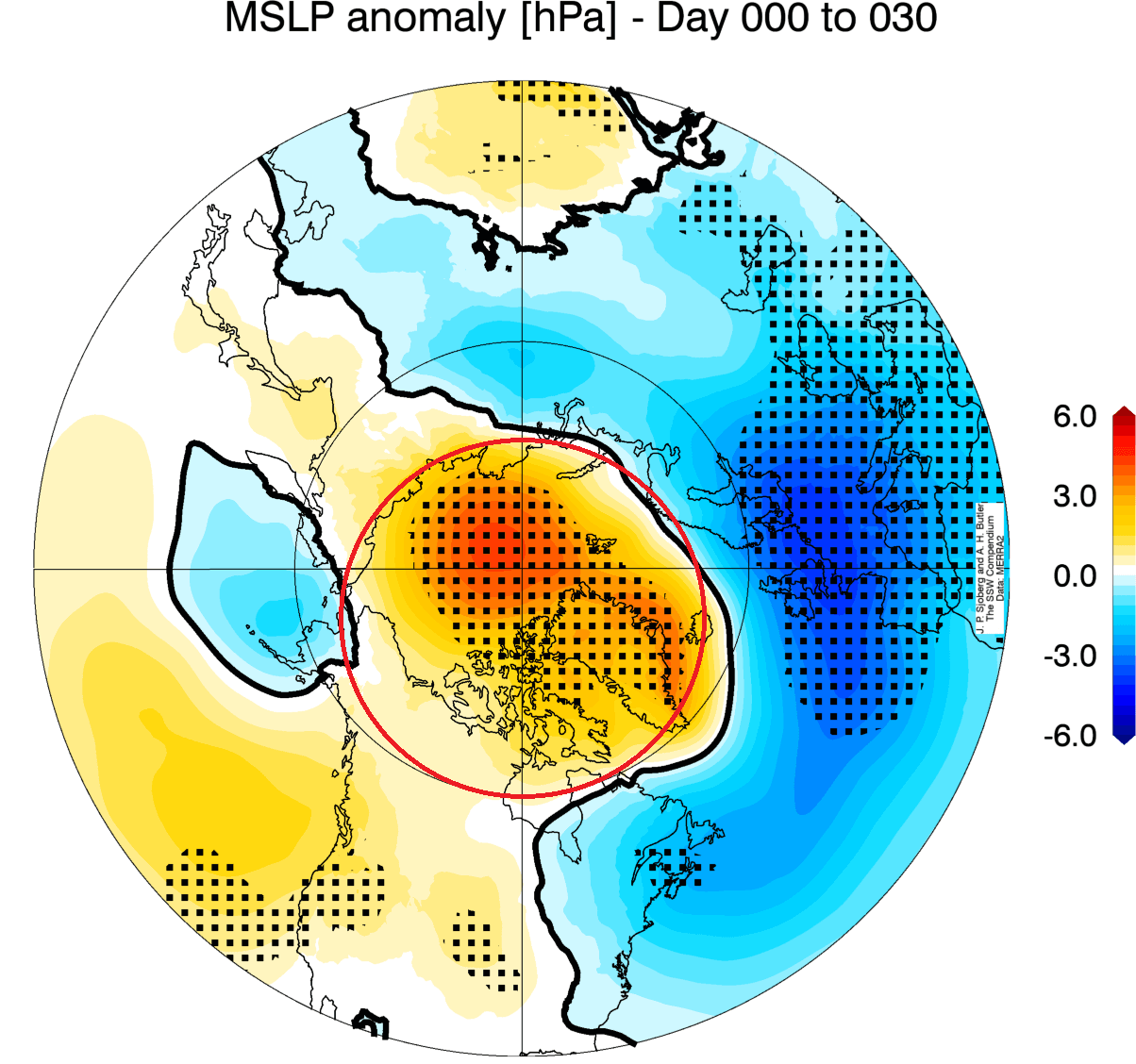
A blocked pole means a weakened jet stream and low-pressure systems from the eastern United States across the North Atlantic and into Europe. This helps unlock the cold air from the Arctic, sending it towards the United States, Canada, Europe, and other mid-latitudes.
We made a data reanalysis and found only 3 stratospheric warming events that occurred this early in the season in the past 70 years. The seasons were 1958, 1968, and 2000, with stratospheric warmings in November. Two of which had a full wind reversal, and with 2000 just a weakening.
Below is the surface temperature anomaly for the following month, December, from PSL. It is very clear that these early events featured a cold weather corridor over Canada and the entire United States, except for the southwest.
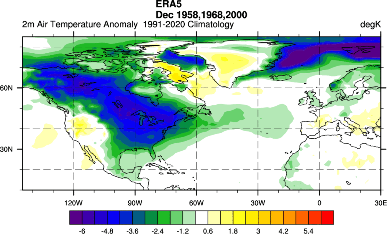
For some reason, Europe shows a rather weak response, with just some cooling evident over the northern and north-central parts. But we can still see a meaningful colder air coverage here too.
As the meteorological winter 2025/2026 season is getting close, we will look at the updated forecasts, which will show us if we can expect the same cold weather response following the upcoming early SSW event.
TIME FOR COLD WEATHER AND SNOW
As we now know, a stratospheric warming event usually means that high-pressure anomalies from the stratosphere can make their way to the surface. This disrupts the weather systems, releasing cold air from the polar regions down into the United States, southern Canada, and Europe. At least in most events.
Below is the surface pressure anomaly forecast for the first half of December, and we can see the expected high pressure building around and into the polar regions. You can see that the main surface core of the Polar Vortex is being displaced into North America.
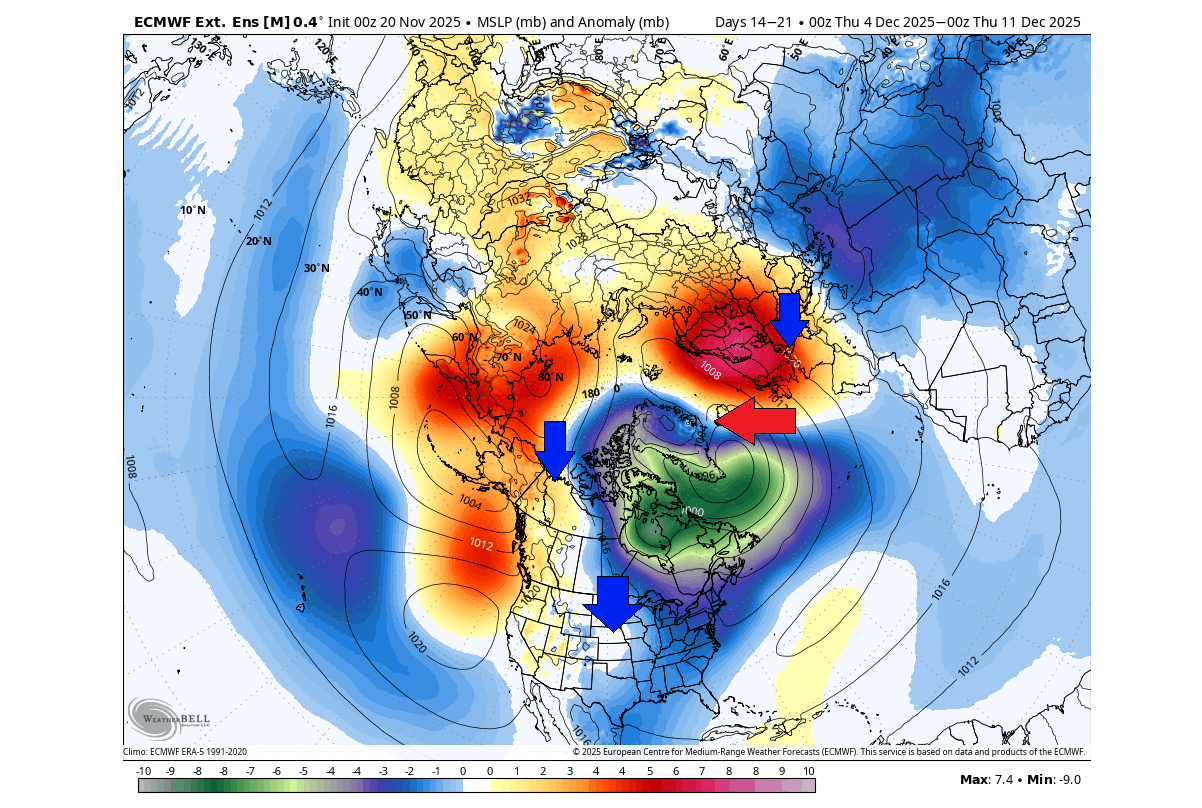
This Polar Vortex core spins counter-clockwise, which means a strong northerly flow from the Arctic down into Canada and the United States. At the same time, it brings a southwesterly flow into the far North Atlantic.
This puts the main impact region into North America for now. If we look at the 500mb (5km/3miles) pressure anomaly forecast for the whole of December, you can see a strong Polar Vortex core being pushed into eastern Canada and the northeastern United States, affecting the whole continent.
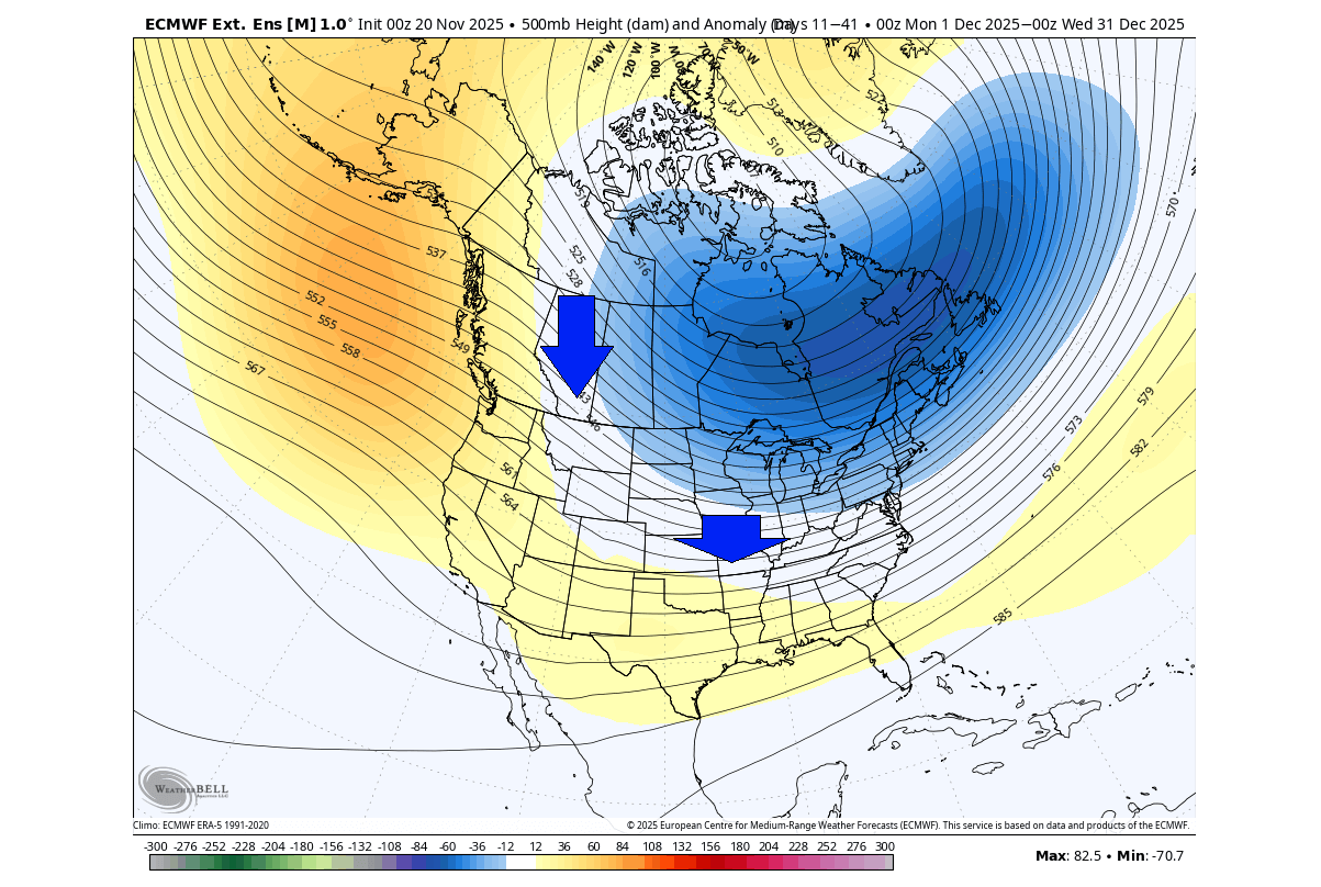
Having a core of the lower Polar Vortex in this region creates a sustained northerly cold flow into the United States down from western and southern Canada. This is a strong sign of a cold and snowy start to meteorological Winter across the United States and Canada.
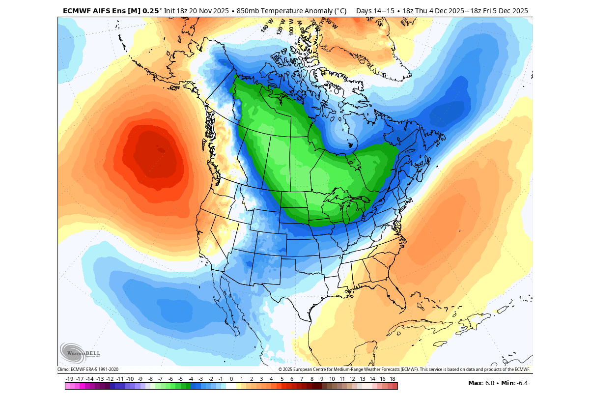
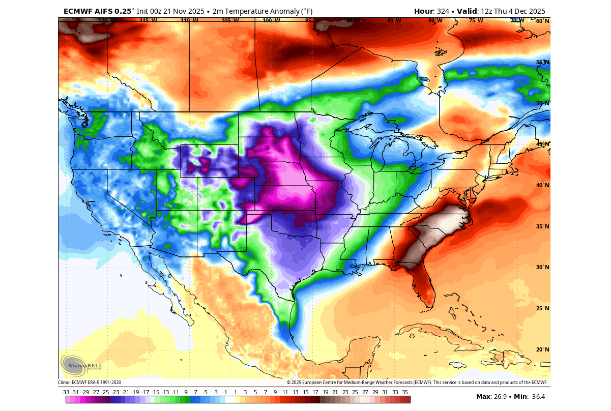
The temperature forecast for the first week of December indicates a potentially strong cold (polar) air outbreak across the northern, central, and northeastern United States. This exactly fits the pressure pattern above, with the lower Polar Vortex core acting as a “pump” for the cold air into the United States.
One of the individual scenarios for this time also shows a rather significant cold air spill into the United States from the north to central, south, and then spreading east. But this is just a single run at a longer range, so it should only be taken as an example of a potential scenario.
Looking deeper into late December, we can see the cold air anomaly continues to linger and spread over southern Canada and into the United States. We can take this as an indication from current forecasts that the northerly flow will remain stable, pulling colder air from the deep polar region and transporting it down into the United States during the holidays.
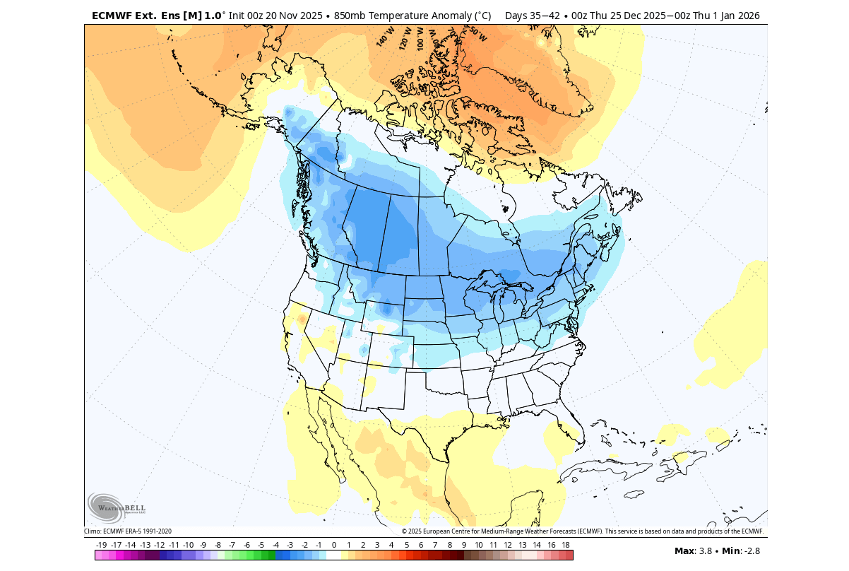
With the local Polar Vortex core over Canada, such a pattern could stay stable into late December, increasing the chance of a white Christmas across many parts of the United States.
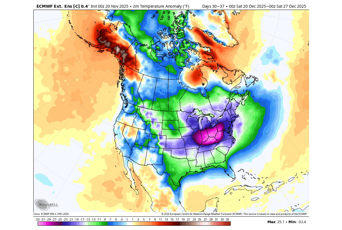
One of the extended-range scenarios currently shows a significant cold-air release across southern Canada and most of the United States in mid-late December. This is directly related to a strong local core of the lower Polar Vortex, bringing down a cold air anomaly. Again, this is just an individual forecast that shows what is possible after a stratospheric warming event.
The snowfall forecast for December shows a good spread of total snowfall from Canada into the northern, western, and eastern United States, including the southwest. We also see snow cover spreading over the Plains. This is an ensemble average, so we are only looking at coverage, not the actual numbers.
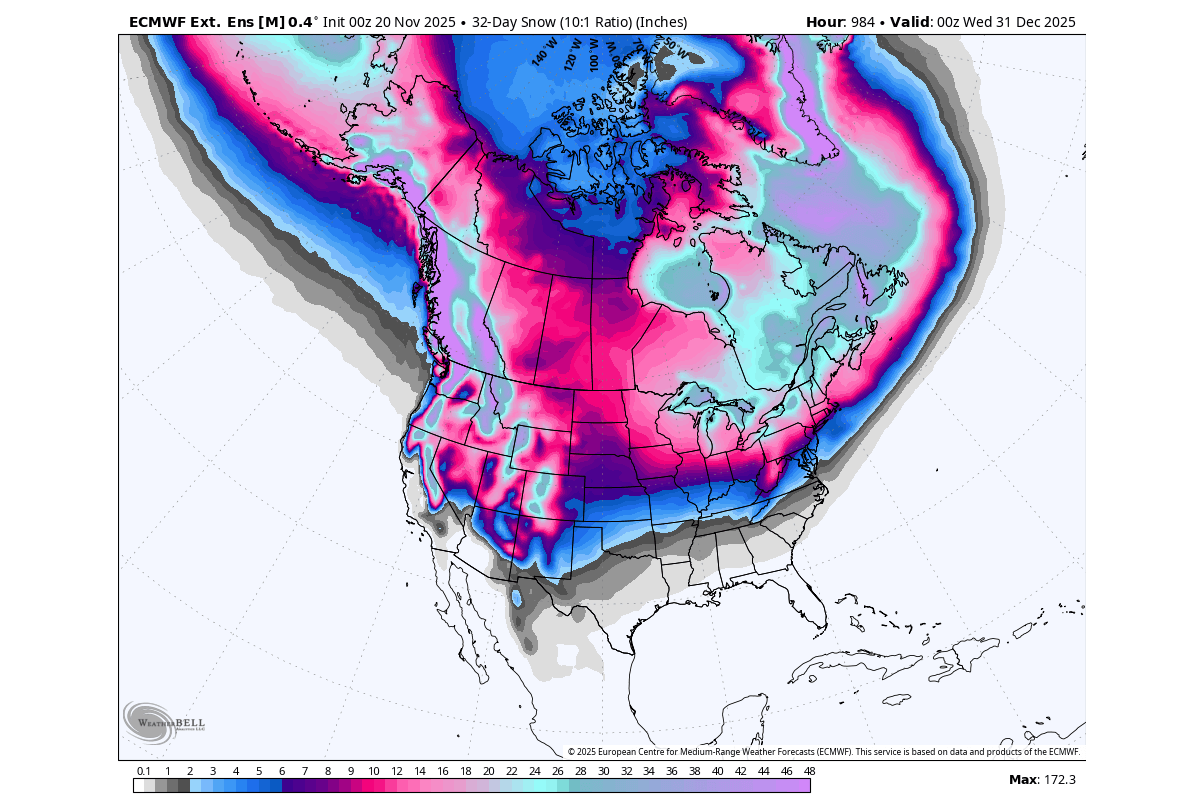
We can take this as another positive sign of a good chance of a snowy Christmas holiday, and it also reaches farther south in the United States than in some recent winters.
We have to keep in mind that this is a far extended range. But what gives us good confidence is that such scenarios have occurred in the past following a stratospheric warming event.
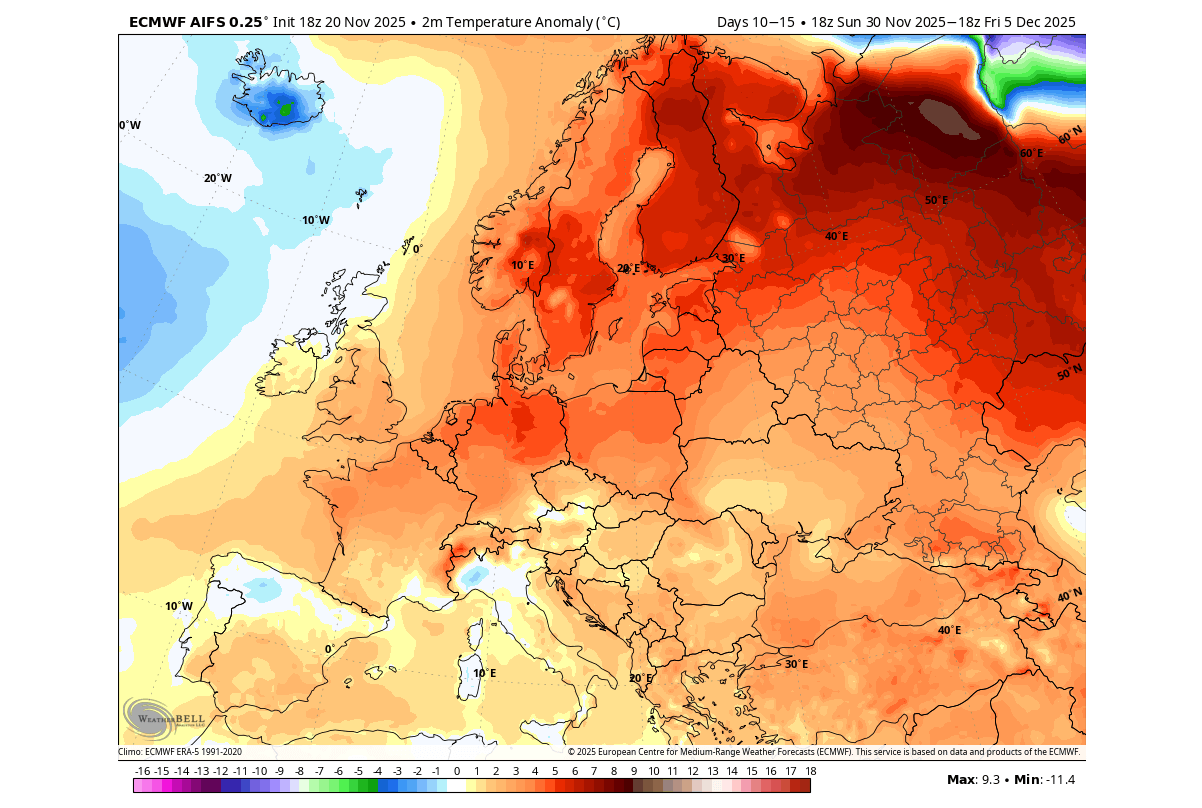
Having the Polar Vortex core over North America is not very favourable for Europe, at least in the beginning. It causes a tendency toward higher pressure and a milder westerly/southerly flow. As a result, the forecast below for early December shows a rather warmer start to the month.
But as we enter the second week of December, we have to look at the extended-range forecasts, and one of the individual scenarios shows a significant weather change. With a high-pressure anomaly further north and a low-pressure system over the south, this causes a strong negative pressure gradient, enabling a cold easterly flow over Europe.
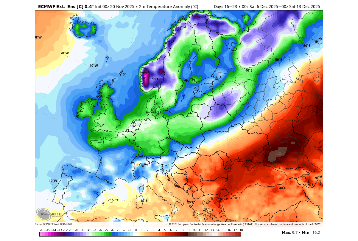
This opens the gates to the cold polar air, releasing it into the northern and central parts of the continent, exactly as one would expect after a stratospheric warming event. This is usually called “the beast from the east”. We will keep a close eye on the potential development of this scenario.
We will also keep you updated on the global weather pattern development, so don’t forget to bookmark our page. Also, if you have seen this article in the Google App (Discover) feed, click the like button (♥) there to see more of our forecasts and our latest articles on weather and nature in general.
The main forecast images in this article are from WeatherBell, using a commercial forecaster license.
Don’t miss the latest full Winter 2025/2026 long-range forecasts: