Severe weather outlook – forecast across Europe. This forecast features areas of organized severe weather with risk levels and severe weather threats across the European continent.
SEVERE WEATHER OUTLOOK
Valid: 09/09/2025 18 UTC – 11/09/2025 06 UTC
Issued by: Severe Weather Europe
Forecaster: Marko Korošec
SUMMARY
The Mediterranean region’s well-above-normal sea temperatures are fueling unusually intense thunderstorms with extreme rainfall events since late August. According to the high-resolution weather models, another high-end flooding risk event is coming up on Wednesday, September 10th, 2025.
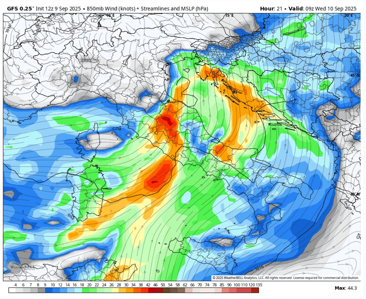
On Wednesday, a deep upper-level trough over western Europe sends its secondary vorticity maximum into the northern Mediterranean, resulting in widespread thunderstorm activity over central Italy, gradually spreading east into the Adriatic region. Again, significantly high precipitable water (PWAT), striking above 50 mm, will lead to torrential, monsoonic rainfall events, dumping high amounts of rain in 12-24 hours, and result in a significant flooding threat.
From Tuesday night into Wednesday, a rather volatile set of environmental conditions combined over the same region as the recent events, supporting severe weather with a trailing-cell effect thunderstorms. Extreme, excessive rainfall with a major flooding threat is forecast, with additional threats of severe winds, large hail, and a few tornadoes (waterspouts) possible.
Multiple rounds of slow-moving severe thunderstorms are forecast for central Italy (Tuscany and Lazio regions) and the Adriatic region (western Slovenia, coastal Croatia, south Bosnia, and Montenegro) from Tuesday night through Thursday morning.
Explanations for abbreviations (TSTM, SLGT, ENH, etc.)
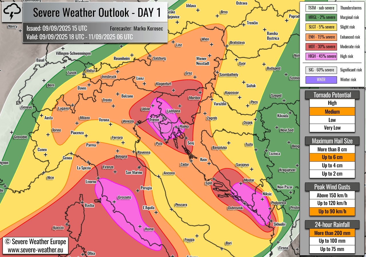
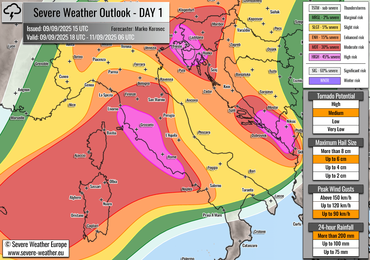
Highlighted severe weather threats:
- Tornado potential: Medium
- Maximum hail size: Up to 6 cm
- Peak wind gusts: Up to 90 km/h
- 24-hour rainfall: More than 200 mm
HIGH risk has been issued for extreme northeast Italy, west-southwest Slovenia, and northwest Croatia. The threat includes extreme, torrential, and excessive rainfall with major flash floods, severe winds, and tornadoes (waterspouts).
In addition, a SIG risk has been placed within the HIGH RISK area where the most extreme rainfall with potentially catastrophic flash floods could occur.
The second HIGH risk has been issued for western portions of central Italy. The threat includes extreme, torrential, and excessive rainfall with major flash floods, severe winds, large to very large hail, and tornadoes (waterspouts).
The third HIGH risk has been issued for extreme southern Croatia, southwest Bosnia, and west-southwest Montenegro. The threat includes extreme, torrential, and excessive rainfall with major flash floods, severe winds, large to very large hail, and tornadoes (waterspouts).
MDT/ENH risks have been issued for areas surrounding the HIGH risk area, including north and central Italy, Austria, southern Switzerland, Slovenia, Croatia, and western Bosnia, with a threat for severe winds, large hail, and torrential rainfall. The expected storm coverage is forecast to be lower than inside the highlighted purple risk area.
This outlook focuses on the 36 hours from Tuesday night through Thursday morning, when a significant severe weather event is expected for the North-Central Mediterranean region. The upper wave axis will emerge from the west, with robust thunderstorms predicted. Supporting intense training cells leading to excessive rainfall that will support potentially catastrophic flash floods.
The severe weather threat will spread from west to east throughout the forecast period.
Above: Video animation of the convective storm’s development across central Europe from Tuesday night through Thursday morning, September 9th to 11th, 2025.
For this reason, HIGH (SIG) + MDT risks have been placed across the northeast Adriatic, central Italy, and the southeast Adriatic region, with highlighted areas where the most robust severe weather and flooding threat will develop on Wednesday.
SYNOPTIC OVERVIEW
The fully matured and extensive upper-level trough over the North Atlantic and western Europe ejects another wave east and south. It is forecast to cross the North Mediterranean regions on Wednesday, establishing another volatile setup.
This is the fourth weather setup of a similar scale over the past two weeks, a rare occurrence despite the region’s proneness to excessive late summer to early autumn rainfall events.
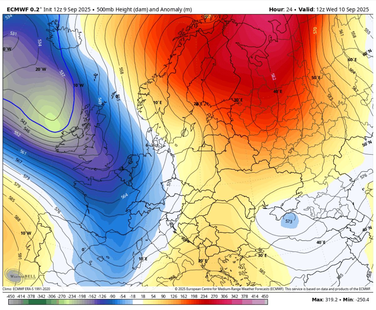
At the surface, an extensive low-pressure system remains centered west of the UK, with a secondary low forming in the Mediterranean in response to the upper wave moving into the region aloft.
This is an essential factor for the area. It also amplifies the low-level flow from the south Mediterranean towards northern Italy, enhancing moisture and instability. Therefore, it increases energy to fuel the frontal system and intensifies it.
This results in a frontal system progressing west to east over central Europe, with widespread thunderstorm activity and intense rainfall for central Italy and the Adriatic region on Wednesday into early Thursday.
WEATHER FORECAST DISCUSSION – Wednesday, September 10th 2025
+++ Weather forecast for Italy, Slovenia, Croatia, Switzerland, and Austria +++
With the emerging frontal wave from the western Mediterranean, powerful south-westerlies aloft are advecting very high moisture from the north-central Mediterranean region.
At the same time, ample wind shear is also overspreading the region, thanks to the intense jet stream aloft. Therefore, a strong upper-level forcing develops near the left-exit region of the jet and supports widespread lifting.
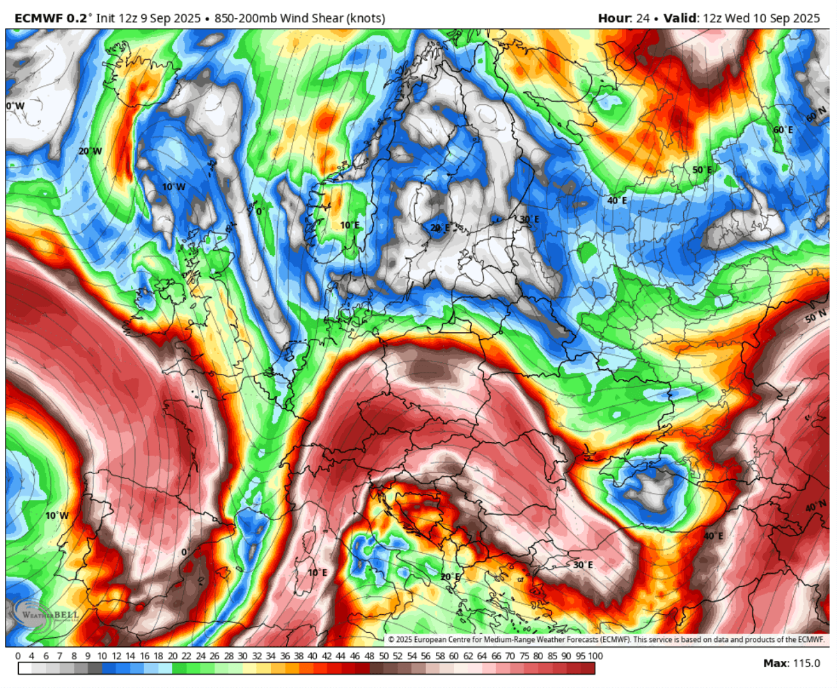
A combination of strong wind shear and instability, mainly when parallel to the frontal zone, will lead to a volatile environment with the explosive development of severe thunderstorms from Tuesday night through Wednesday until early Thursday.
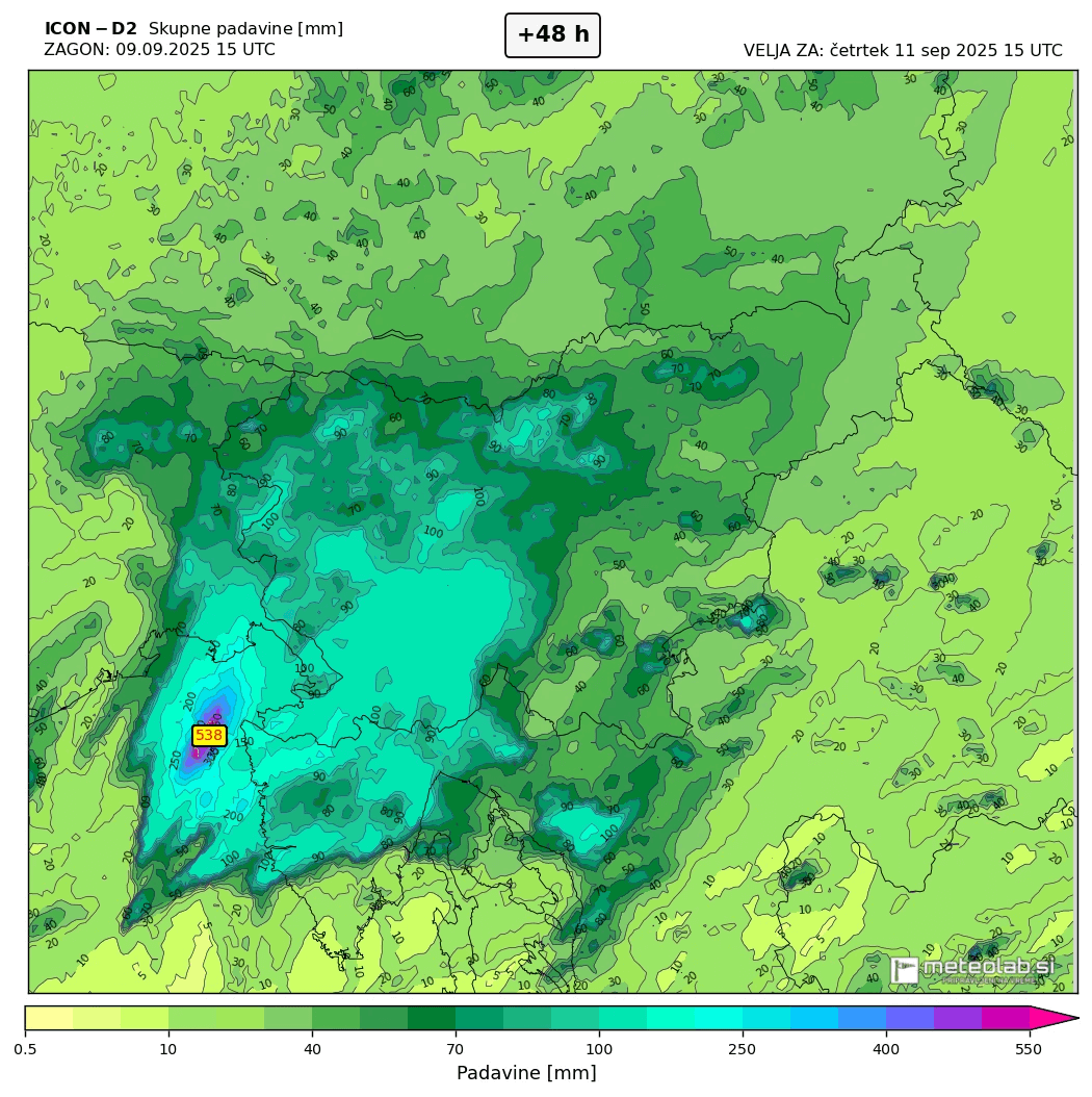
Training multicell and supercell thunderstorms are expected as a primary mode, pushing high moisture in an extremely high PWAT (50-55 mm) environment into the complex terrain of central Italy, west-southwest Slovenia, and northwest Croatia. Extremely intense rainfall is forecast.
This will lead to excessive rainfall within 12 – 18 hours from early Wednesday morning and during the day, bringing rainfall accumulations into the 150-300 mm range across a wide area. Some high-resolution models suggest even more than 400 mm locally.
If these predictions are accurate, catastrophic flash floods could occur, particularly over southwestern Slovenia and northwest Croatia, where the SIG (significant) risk level has been placed.
The background mechanism supporting such a robust environment lies in the substantial low-level moist influx across the south-central Adriatic Sea towards the north, where strong forcing and shear will support explosive thunderstorms with extreme rainfall intensities.
Both low-level shear and helicity hint at supercell thunderstorms along the sharp convergence zone, which could lead to tornadoes and waterspouts. Those are most likely to form in the western and southern portions of the SIG/HIGH-risk level.
The tornado threat is maximized along the coast of northeast Italy to coastal southwest Slovenia and over the west Istra peninsula, where the highest storm-relative helicity and low-level shear will be present.
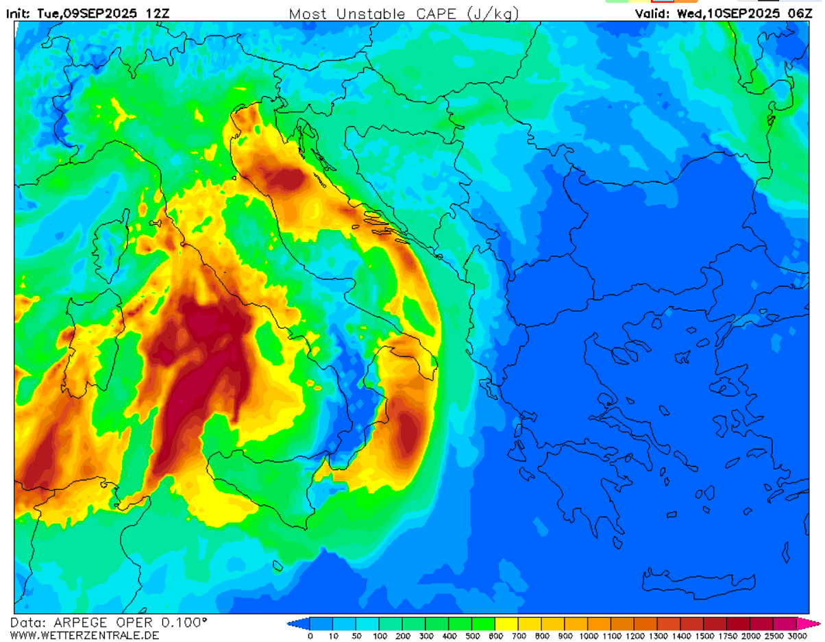
High dewpoints will result in moderate to locally strong instability, with MLCAPE reaching 1500-2000 J/kg over a large part of the Adriatic Sea.
Given the high wind shear and instability combined, most thunderstorms will rapidly become severe, with threats ranging from intense to extremely intense rainfall, severe winds, and tornadoes/waterspouts.
Multiple rounds of slow-moving severe thunderstorms are forecast, which will maintain over the same areas and dump extreme amounts of rain within a few hours. Flash floods and mudslides are easily expected when this occurs, especially after the ground has already been soaked from recent events.
+++ Weather forecast for Italy, Bosnia, and Montenegro +++
On the Ligurian and Tyrrhenian sides of central Italy and the Apennines, training cells and a large V-shaped MCS cluster will form Tuesday night and bring widespread thunderstorm activity. Within high PWAT and unstable air mass, an intense and excessive rainfall threat and flash floods will develop.
This will bring rainfall sums from 100-250 mm within 12-18 hours, possibly even larger. For this reason, a HIGH RISK level has also been introduced for this region. Flash floods are expected to form quickly.
A few tornadic waterspouts near the coast of Tuscany and Lazio regions will also be possible, as storms will be fueled by extreme CAPE and high low-level shear along the coast.
…
Late Wednesday into Thursday morning, the upper wave’s eastward progress will bring robust thunderstorm activity into the south-central Adriatic coast of Croatia, followed by southern Bosnia. Thunderstorms will tend to merge into clusters and move further east-southeast along the eastern Adriatic region towards Montenegro.
This should prompt extreme rainfall from the orographic lifting and convective activity. Rainfall sums could easily reach 200-300 mm within 24 hours, leading to flash floods.
For this reason, HIGH and MDT RISK levels have also been introduced for extreme southern Croatia, southern Bosnia, and south-west Montenegro. Flash floods will occur.
Following your local meteorological office/agency for the latest updates and potential warning messages is advised.
Wetterzentrale, Meteolab, Wxcharts, and WeatherBell provided images for use in this article.
See also:
Another high-risk rainfall and flooding event for the Northern Mediterranean on September 10th, 2025