The stratospheric Polar Vortex is entering its final seasonal phase, undergoing a Final Warming event that signals the end of its winter dominance. But as the high-altitude circulation dissipates, it releases the lower-level Polar Vortex core, bringing another round of weather impacts across North America and Europe in April 2026.
The latest analysis confirms that a residual Polar Vortex core remains active in the lower atmosphere, centered over North America and eastern Canada. This core fragment is expected to bring some level of weather impacts across the United States, delivering late-season snowfall and below-normal temperatures.
In this April 2026 update, we analyze the final downward waves of the stratospheric collapse and their impact on the North Hemisphere weather patterns. We also look at the mid-month outlook for the United States and Europe, the persistence of the residual Polar cold core, and the potential for an Omega Blocking pattern to emerge as the atmosphere resets for the remainder of the Spring season.
The Polar Vortex: An Atmospheric Winter Engine
We often talk about the Polar Vortex, and we have covered a lot of theory so far during the Winter season. But we still like to add some basic explanations for our new readers, especially since the dynamics change significantly when we head into Spring.
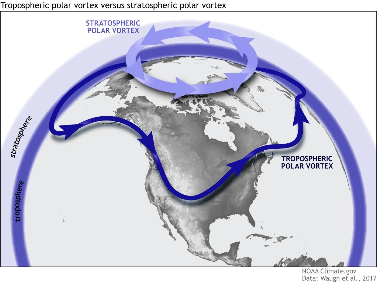
In simple terms, the Polar Vortex is a broad winter circulation over the northern (and southern) hemispheres. You can imagine the Polar Vortex as a spinning wall over the polar regions, rising from the surface into the stratosphere (over 50km/30 30miles high), trapping the cold polar air inside.
The Polar Vortex is divided into two layers: the stratosphere (at higher altitudes) and the troposphere (at lower altitudes). These two layers are interconnected but have very different roles. This is very important once we get into Spring, as the upper (stratospheric) part dissolves, and the lower part becomes fully dominant.
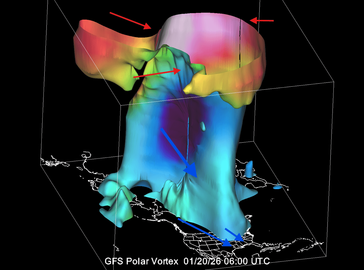
Below is a 3D example of the mid-winter Polar Vortex structure, where it works as a whole unit. You can see the upper (stratospheric) part and the lower (tropospheric) part. In this example, you can see a stratospheric warming even in the upper levels, which impacted the whole structure downwards, creating a cold outbreak in the northern, central, and eastern United States.
Such a disruption comes from a rise in stratospheric pressure and temperature, known as a Stratospheric Warming(SSW) event, or from other dynamics that can originate from the lower levels.
To better show the Polar Vortex structure in its true form, we produced a high-resolution video below that shows the January disruption of the Polar Vortex structure from a Stratospheric Warming event. You can see how the whole Polar Vortex structure behaves as one system.
By April, the stratospheric Polar Vortex can’t withstand the seasonal warming of the stratosphere and eventually dissolves. This removes the atmospheric wall that keeps the cold air centered, allowing the lower-level Polar Vortex cores to fragment and wander.
This transition can rapidly shift the atmosphere from a stable late-winter pattern to a highly volatile spring setup, where cold-core fragments are free to wander around the mid-latitudes without the stratosphere locking them into the north.
The Stratospheric Reset: How the Final Warming Dissolves the Polar Vortex
The most common way we monitor the stratospheric Polar Vortex is by looking at wind speeds around the polar circle. A strong positive (westerly) wind indicates stable conditions or a strong Polar Vortex, but weak or even negative (easterly) winds indicate a complete reversal and/or dissolve of the Polar Vortex in the stratosphere.
Below is the stratospheric wind analysis/forecast by NASA for the current 2025/2026 season (red and purple lines). Ignore the blue line, which shows the last season. You can see that this winter, the Polar Vortex was weak in the stratosphere. In recent days, it’s running around 0, which means that it’s dissolving, going into its “summer slumber” mode.

This tells us that the regime is shifting away from any real stratospheric influence, apart from any last waves or residual cores. This seasonal warmup and Polar Vortex breakdown is also called the Final Warming event.
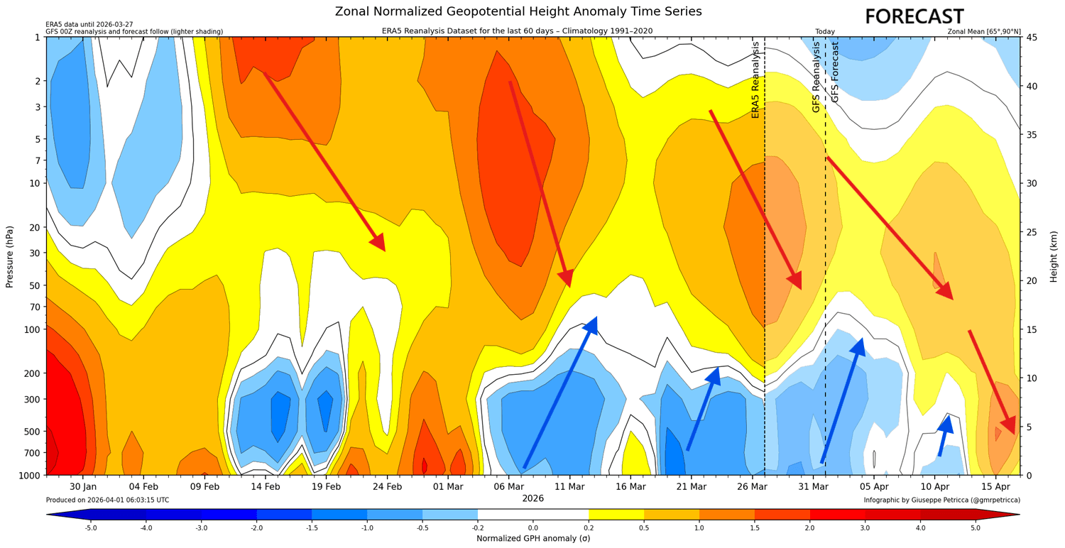
The image below shows a vertical structure of the atmospheric pressure anomalies, from the surface up to the top of the stratosphere, since late January. In the forecast section, you can see the final downward waves of disruption arriving in April as the stratospheric Polar Vortex dissolves from the Final Warming event. Image by hebweather.net
This is the classical high-pressure propagation downwards, connecting with the lower levels. This can displace the lower-level Polar Vortex core, pushing it into a single region, such as North America or Europe, for example.
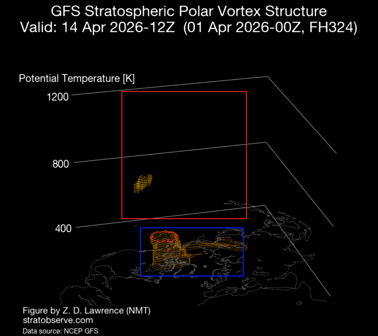
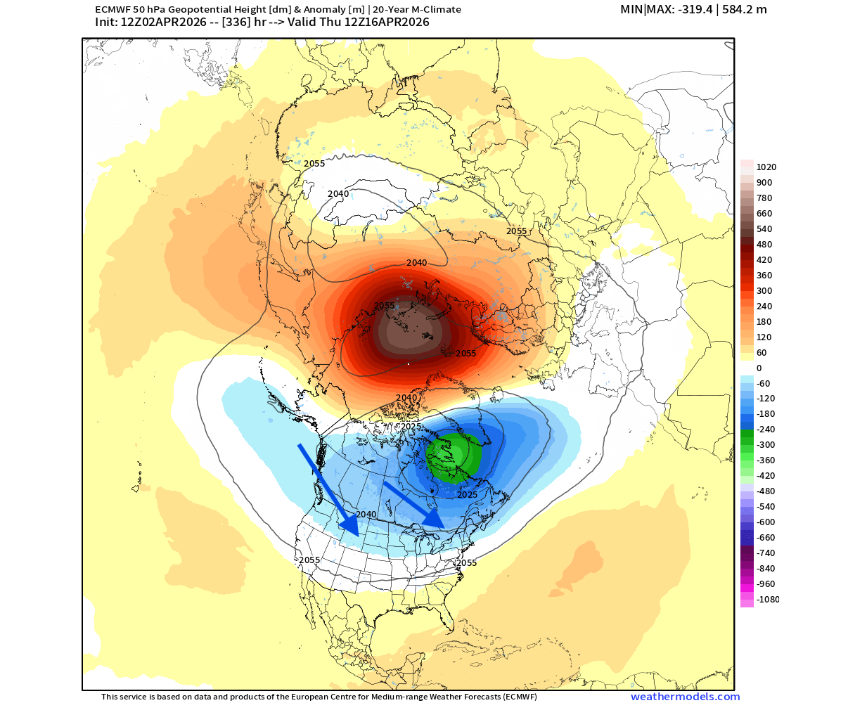
This change in dynamic is nicely seen in the Polar Vortex 3D forecast below for mid-April. The red zone shows the mid-upper levels of the stratosphere, where the Polar Vortex is pretty much non-existent. But in the lower stratosphere and the troposphere (blue zone), you can still see an active Polar Vortex core, as the lower Polar Vortex remains active longer.
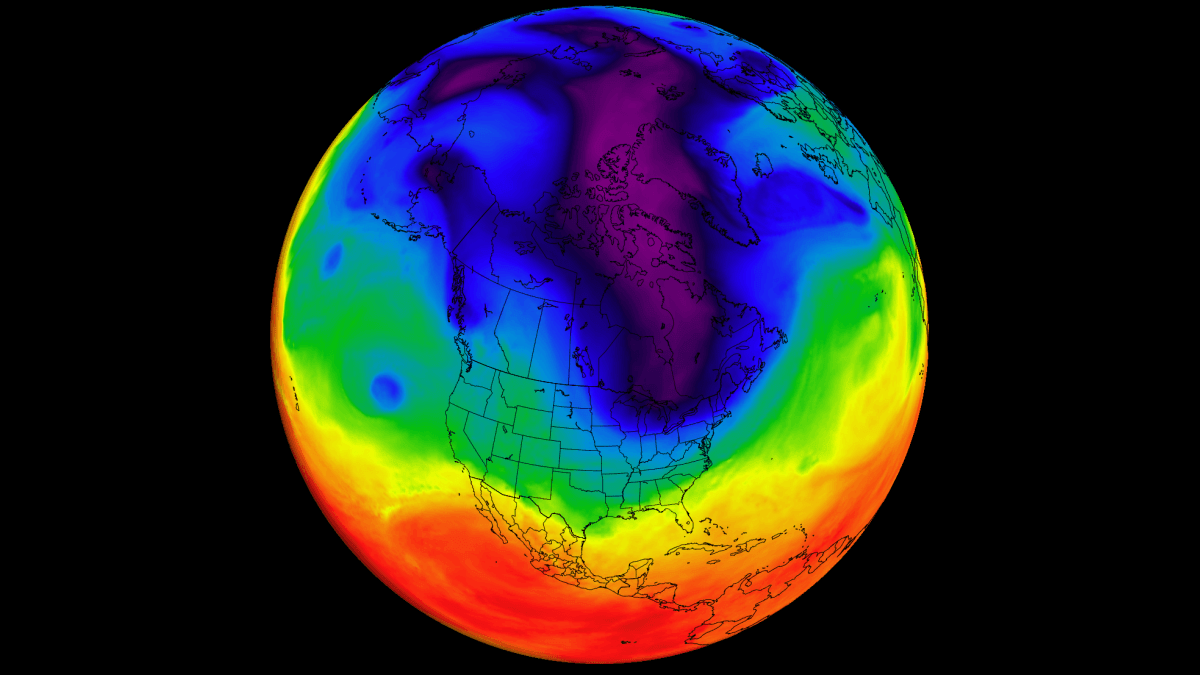
In the image below, you can see the latest analysis for the mid-stratosphere at the 10mb level (30km/18.5miles height). The Polar Vortex is clearly defeated, with only a small residual core remaining over the polar circle. Stratospheric temperatures are rising seasonally as the sun’s angle increases above the polar regions, and won’t cool back down until Fall. Image by weatheriscool.com
The true power and the engine of the stratospheric Polar Vortex comes from the temperature difference between the cold polar stratosphere in winter, while the tropical regions are still warm. This causes a strong temperature difference, lowering pressure over the pole, and starting a strong polar circulation. This stops once the polar regions start to warm in spring, and the difference is reduced.
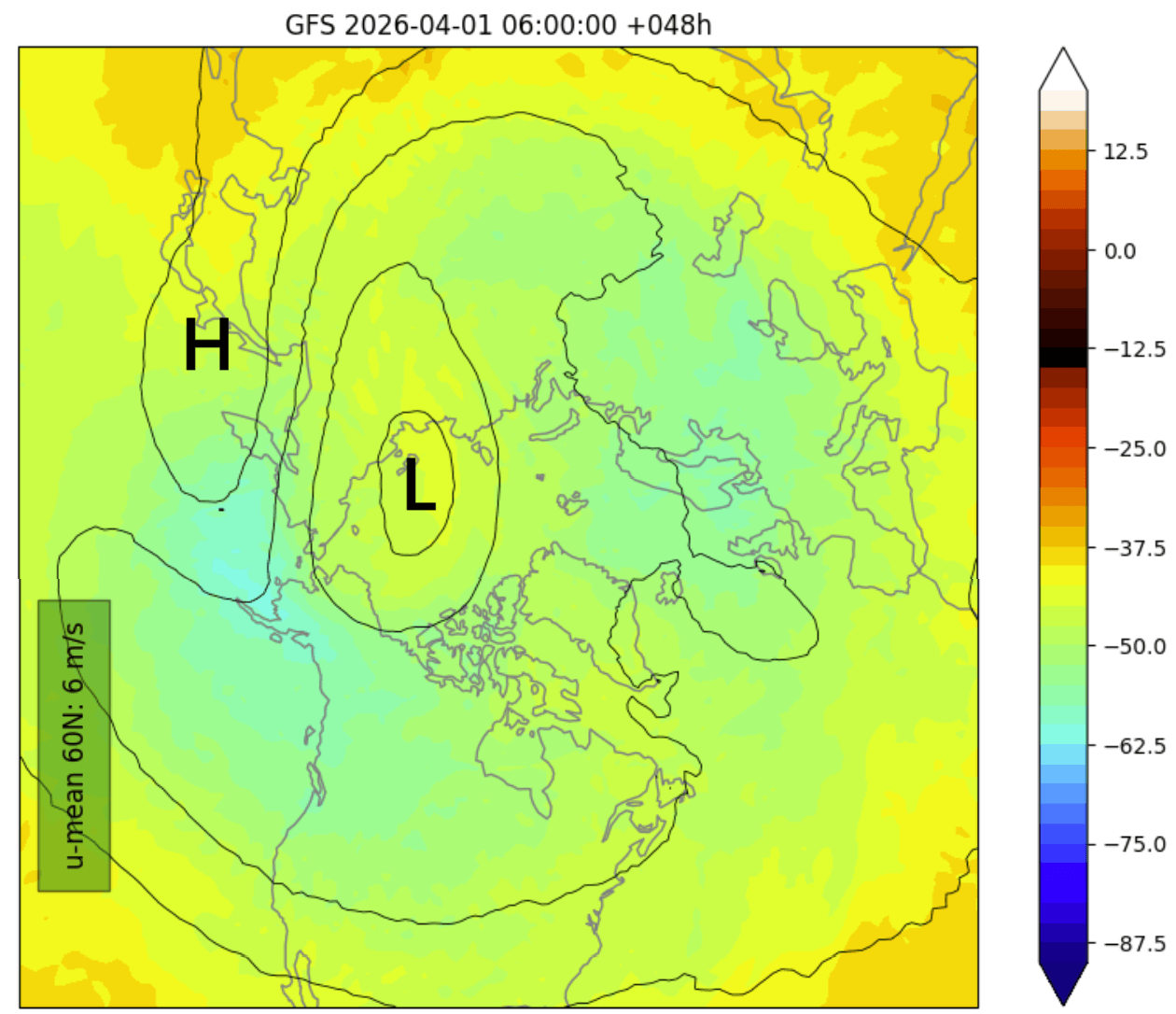
Below you can see the pressure anomaly forecast for the lower stratosphere at the 50mb level (20km/12.4 miles). There is a high-pressure zone over the polar regions, but the main lower Polar Vortex is almost stationary over North America, still strong enough to reflect on the weather patterns below.
What this does is it enables a more westerly flow across the United States, with a constant risk of colder air coming down from the north, as a low-pressure system moves across the northern United States, traveling around the Polar Vortex core area. It also enables a milder/warmer flow into Europe.
If we were at the peak of Winter, the impact of such a Polar Vortex core position would be fantastic for winter fans in the United States. But as we are already in Spring, the pressure patterns behave a bit differently.
April Pattern Forecast: A Residual Polar Vortex Core Targets North America
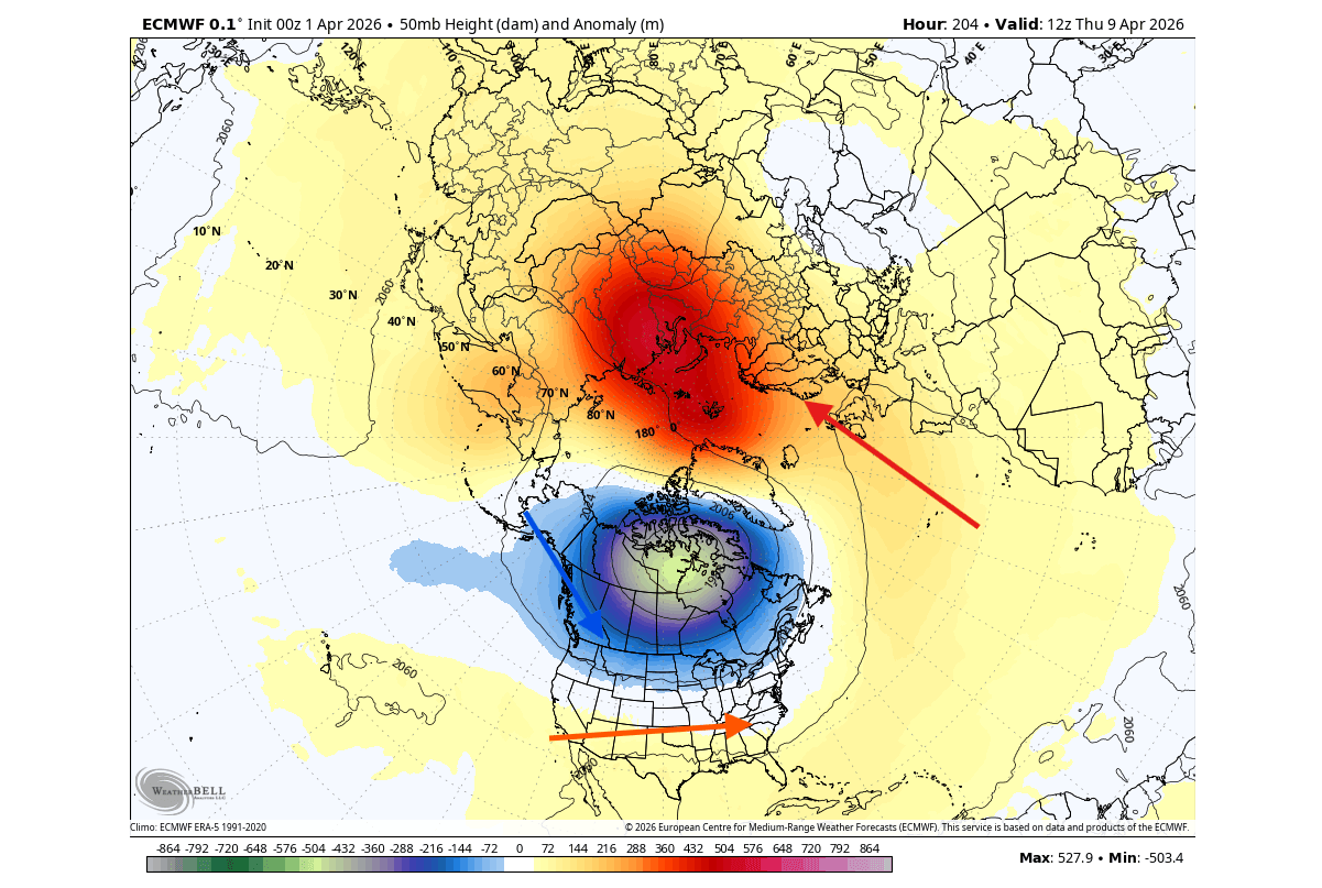
Below you can see the pressure anomaly pattern for the first week of April. What stands out is the low-pressure core area over eastern Canada and the North Atlantic. This low-pressure zone is part of the remaining lower stratosphere Polar Vortex core.
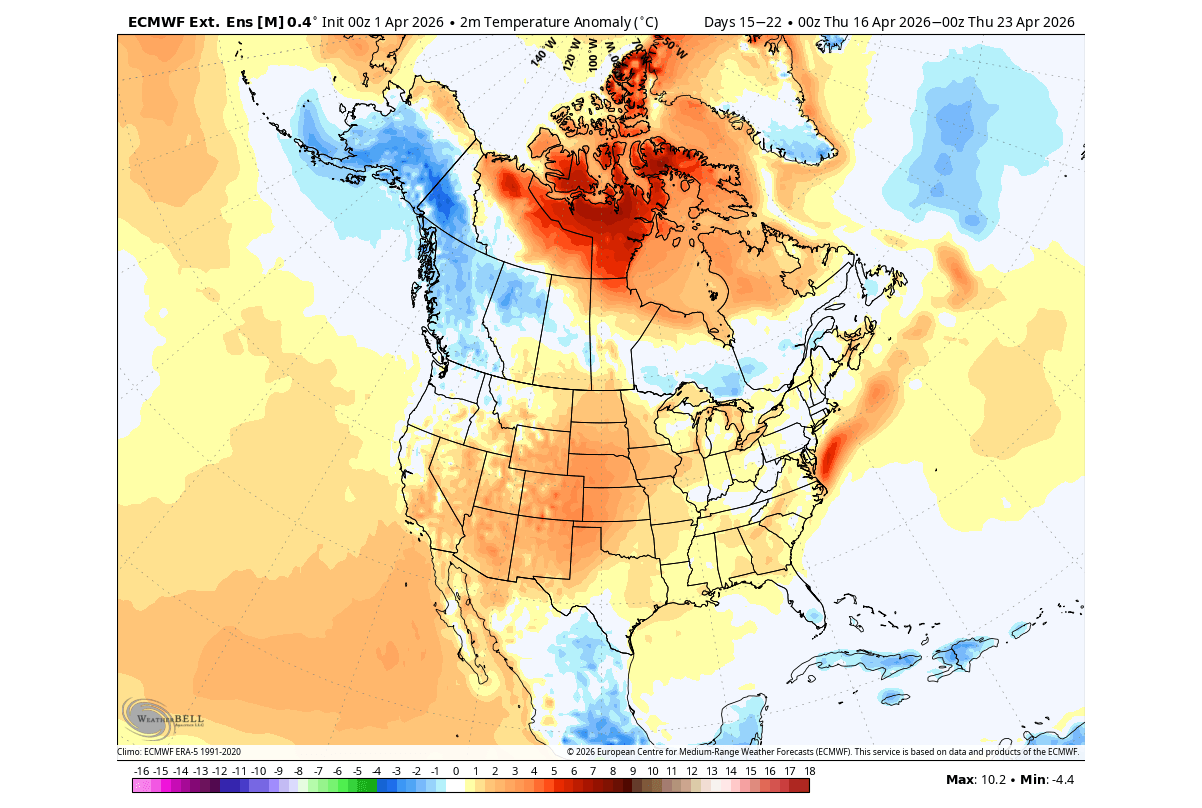
This also indicates a potential colder airflow period over the northern and eastern United States, as the Polar Vortex core pulls down a more northerly airflow. At the same time, a warmer westerly flow enters Europe.
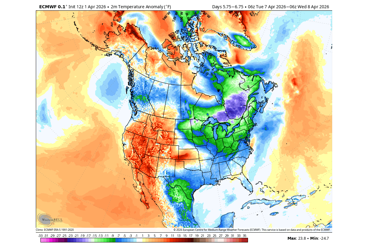
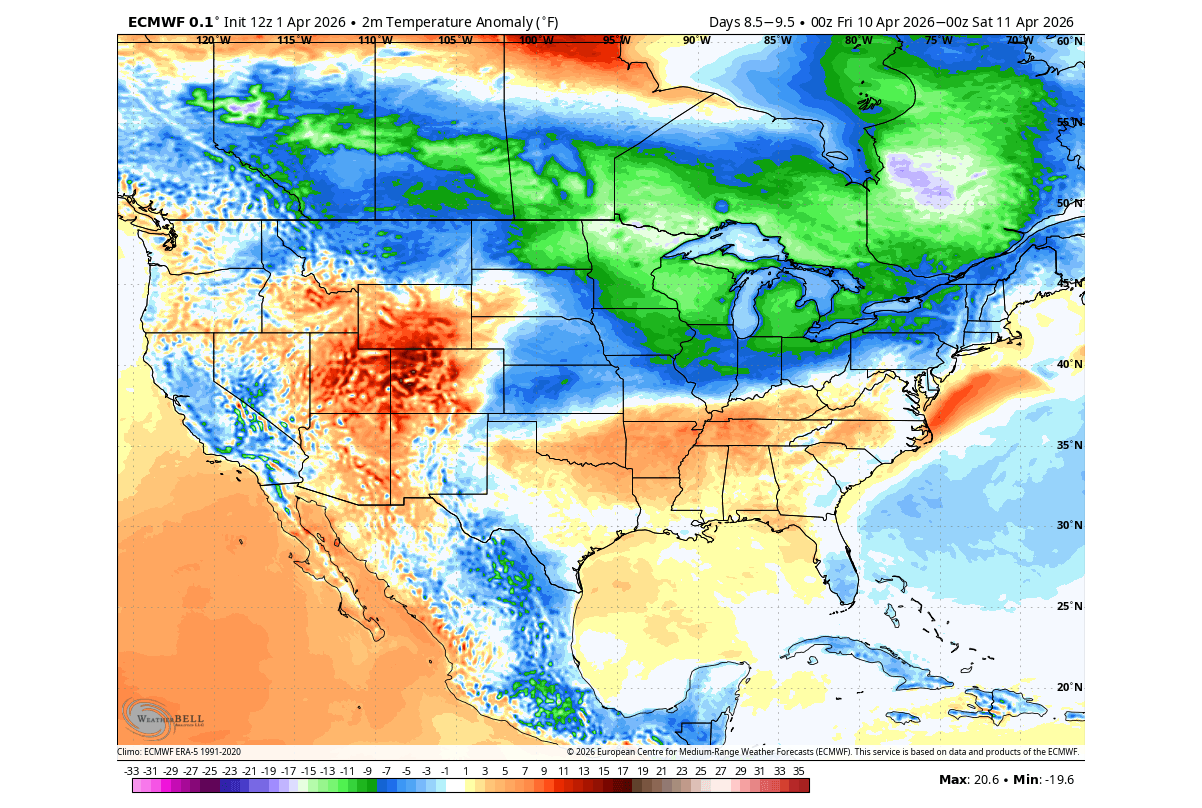
The temperature anomaly forecast for the first week of April shows an area of below-normal temperatures over eastern Canada and the northern United States. This is the airflow around the Polar Vortex core. At the same time, a warmer airmass will spread across the central and eastern United States on the westerly and southerly flow.
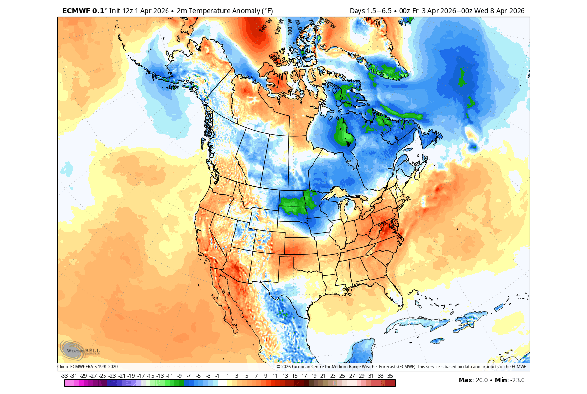
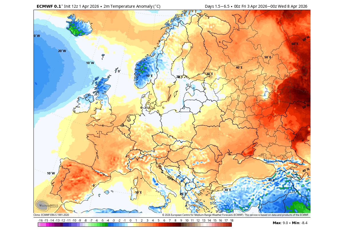
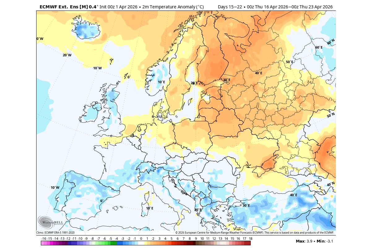
Over Europe, this first week shows the return of normal to above-normal temperatures, associated with a pressure rise, and a more mild westerly and southerly airflow. Overall, the forecast shows a rather normal start to the month, as far as temperatures go.
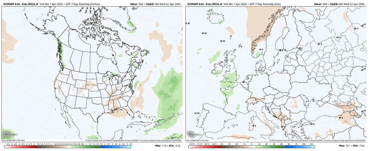
The 7-day precipitation anomaly shows more rainfall over the upper Midwest, the central and south-central United States. More precipitation is also forecast over the northern United States and towards southeastern Canada, with a large part expected to fall as snow.
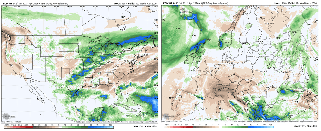
Over Europe, we can see the dry area over the central parts, associated with the expanding high-pressure zone. More rainfall is expected over the southeast, under a low-pressure zone, and over the northwest.
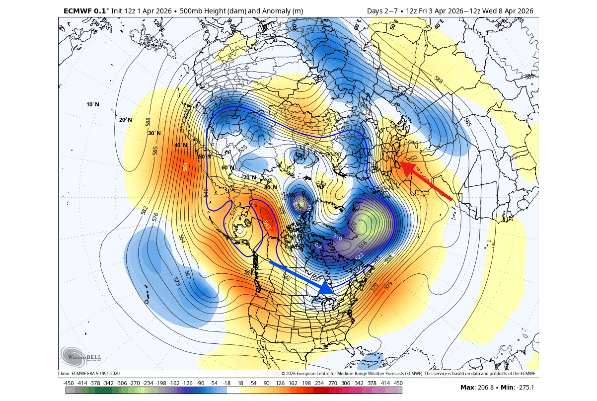
But looking in more detail at early next week, the pressure forecast reveals a proper low-pressure core of the lower Polar Vortex over eastern Canada, reaching into the northeastern United States. This enables a return of a northwesterly flow and lower temperatures.
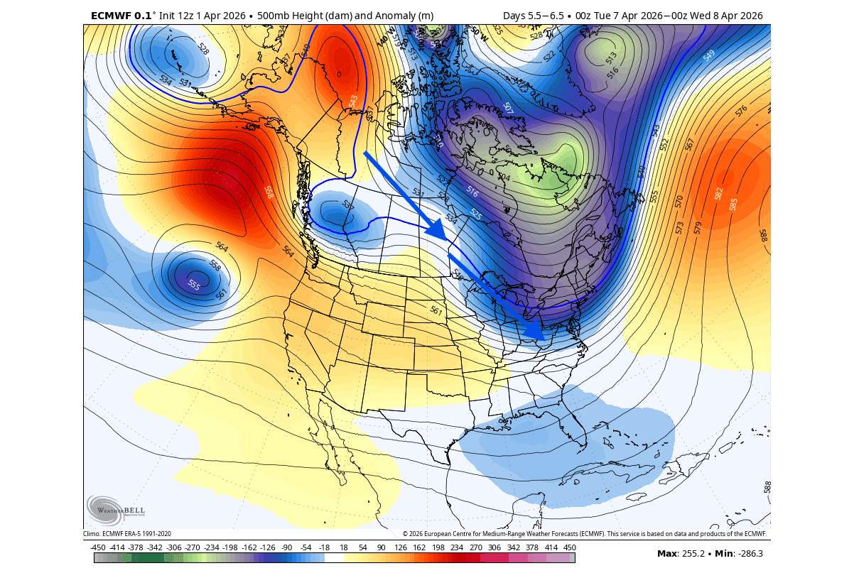
The temperature anomaly for the same period shows colder than normal temperatures over much of the Midwest, covering also the northeastern United States and eastern Canada. This is a direct result of the low-pressure zone associated with the residual Polar Vortex core, pushing temperatures 10-20°F below normal in the area.
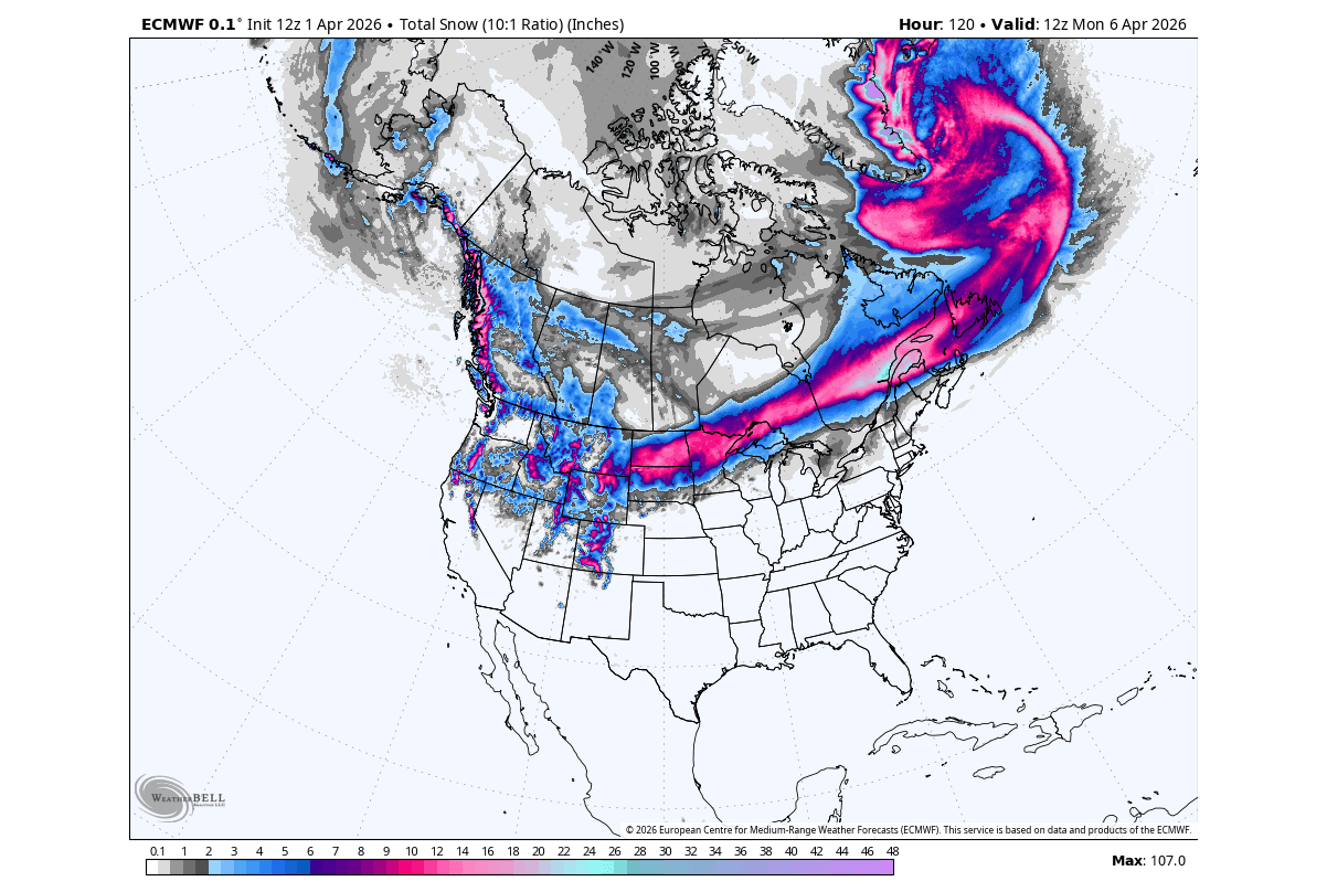
The snowfall forecast is subject to change, but the airmass will be cold enough to bring fresh snowfall into much of the northern United States, also reaching in a band near the Great Lakes and into eastern Canada. Some snowfall is also expected in the northeastern United States, but the snow accumulation on the ground will be limited.
But looking at current weather conditions, a cold airmass will already bring winter weather to much of the northern United States, and also across the northeast. In the image below, you can see the forecast for the Winter Storm Severity Index for days 1-3, based on official NOAA data.
The most severe disruptions are centered on the Northern Plains and Upper Midwest, with a dangerous corridor of Major and Moderate impacts stretching across North Dakota, South Dakota, and Minnesota. In these states, heavy, wet snow and significant ice accumulations can make travel difficult. Wisconsin and Upper Michigan can deal with hazardous icing that threatens power lines and morning commutes.
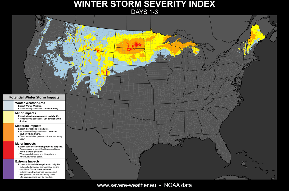
This pressure system is also impacting Montana, Wyoming, Idaho, and Utah, which are seeing widespread Minor impacts, though the Colorado Rockies show more intense, Moderate to Major winter storm impacts.
We can also see wintry conditions over the Northeast. Maine is currently under a Moderate impact signal, with New Hampshire, Vermont, and upstate New York experiencing a round of “winter in spring”, thanks to the proximity of a Polar Vortex core.
But this Polar Vortex core is expected to persist over Canada toward mid-month, while a high-pressure zone is established over the polar regions.
Mid-Month Outlook: The Persistent Core and the Risk of Late-Season Cold
Going into mid-April, the pressure forecast shows the persistent low-pressure Polar Vortex core over northern Canada, and a high-pressure zone over far northern Europe and over the polar regions. This has continued northwesterly flow support over the northern United States. A low-pressure extension can also bring lower temperatures to Europe.
Over the northern United States, this pattern usually brings a cold front scenario, with below-normal temperatures over the northern states. Over Europe, a split-flow pattern can bring a round of below-normal temperatures.
We can again look into the lower stratosphere at the 50mb level (20km/12.4 miles) for mid-month. You can see that the main Polar Vortex core is forecast to shift further east, while generally remaining over North America, supporting a potential northerly flow event, and confirming a robust low-pressure area is likely in the lower levels.
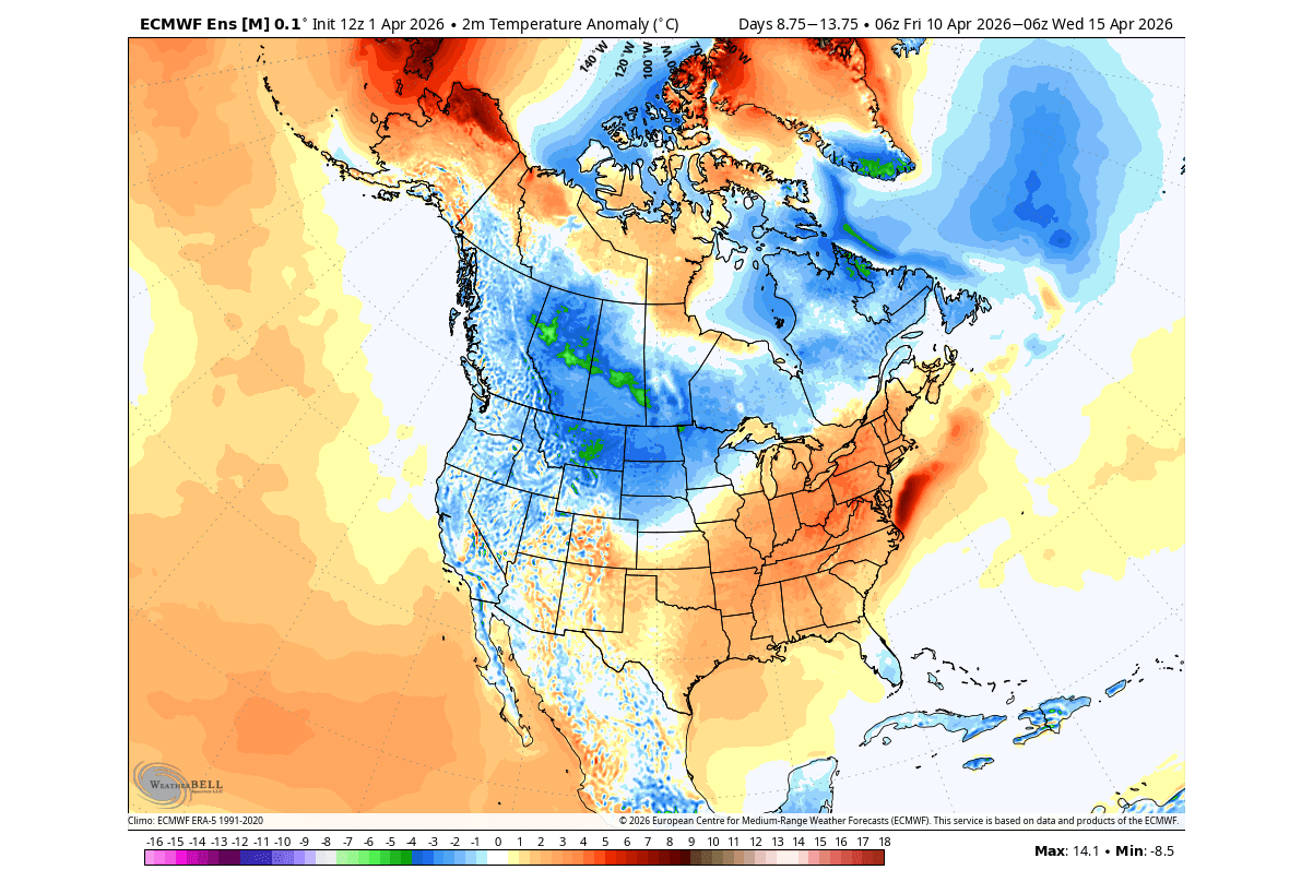
We can see this northerly flow in the temperature forecast below, which shows the same period, and cold air following the strong low-pressure system over Canada and across the northern United States. At the same time, a southerly flow will be established under this low-pressure system, bringing warmer temperatures into the eastern United States.
This is because a low-pressure system spins counterclockwise, which means a northerly flow behind it, and a southerly warm flow in front of it. This enables a brief warmup period over the eastern United States.
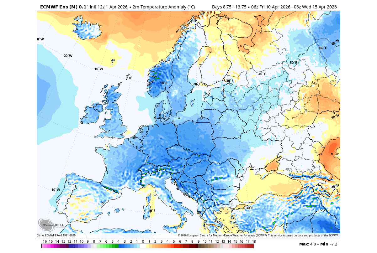
Over Europe, we can see that the second week of April calls for lower temperatures again, driven by the combination of a low-pressure system and a properly positioned high-pressure area over the north.
The precipitation forecast for this period shows a frontal system over the Midwest, also reaching down into the southern United States. Less precipitation is forecast over the East Coast and the southeastern United States.
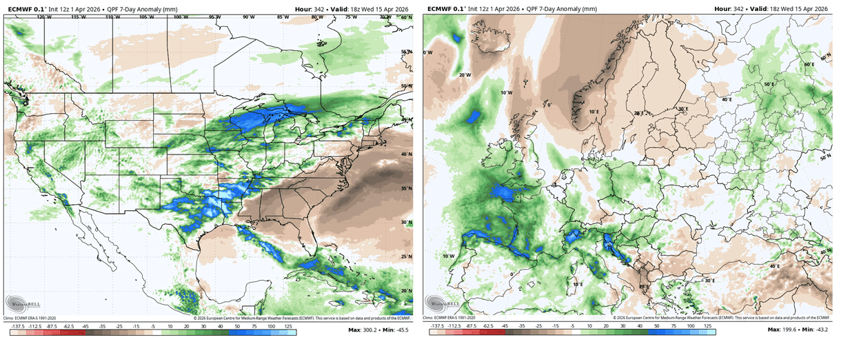
This period will also bring a reversal in terms of precipitation, as the forecast shows above normal precipitation over the central and western parts of Europe. At the same time, drier conditions will establish over northern Europe under a high-pressure zone.
A more interesting situation is currently forecast later next week, with a cold air spill down from Canada into the northern, central, and northeastern United States. We can see a strong temperature contrast, with the northerly flow meeting a warmer airmass to the south.
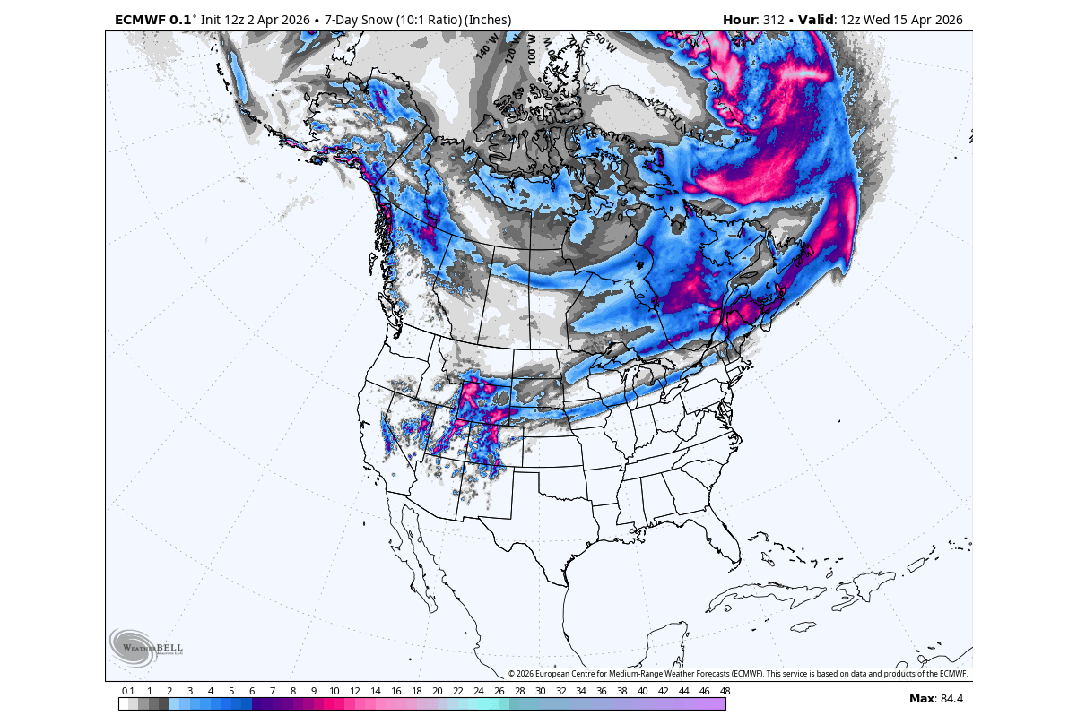
In early spring, the northerly flow is still cold enough to sustain snowfall. In the forecast image below, we can see the total 7-day snowfall pattern for the second week of April, and it shows more snow banding over the Midwest and upper Midwest, covering also the eastern United States.
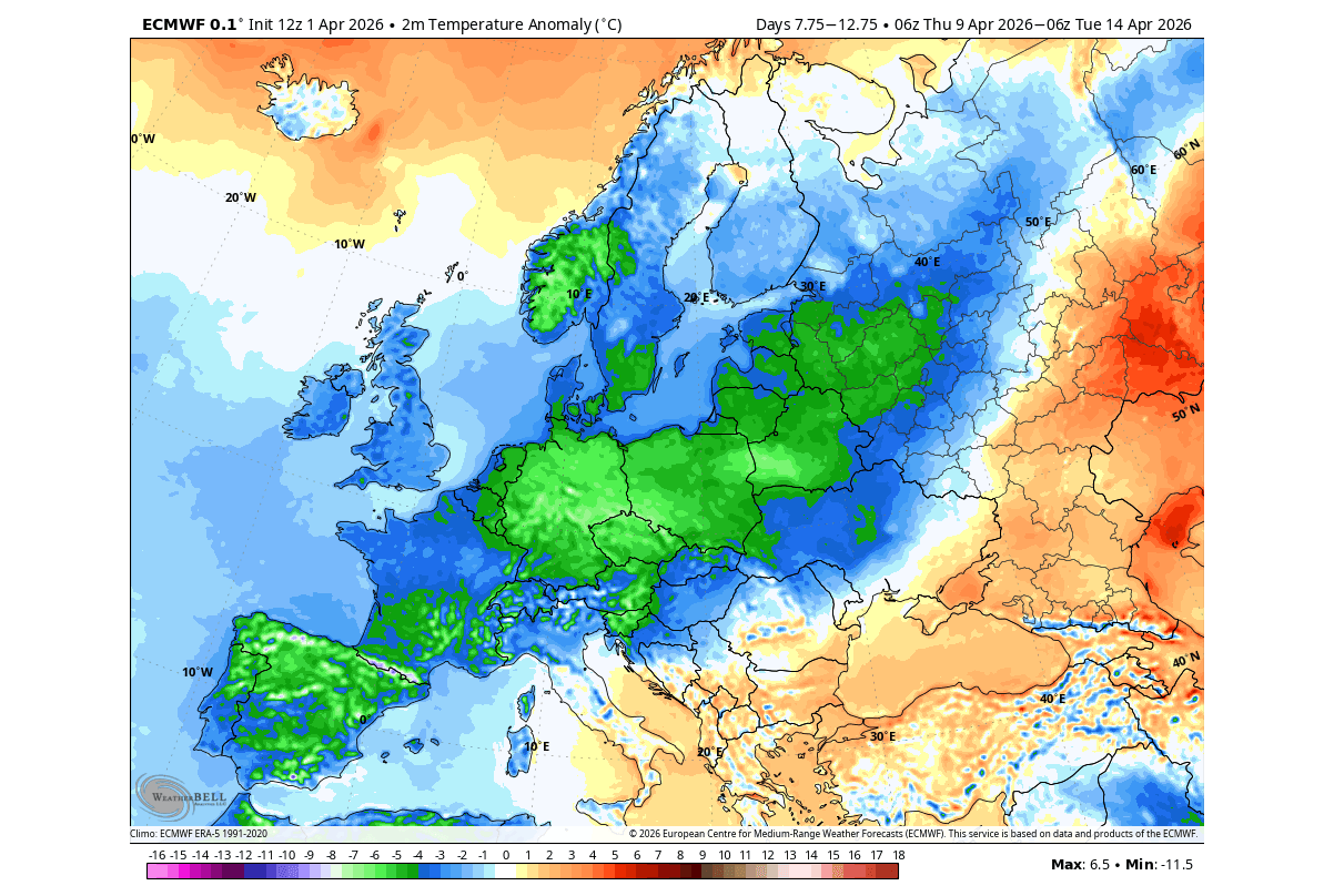
Over Europe, the operational forecast does show a cold air spill over much of the continent. This is not winter-cold, but it is unseasonably cold for this time of year, with temperatures 5-10°C below normal.
As we head into the second half of April, even the lower Polar Vortex core is expected to weaken further, as the temperatures rise, but a special type of high-pressure blocking may establish.
Late April Trends: Omega Blocking and the Final Atmospheric Transition
For the second half of the month, we tend to use the ECMWF extended range forecast. But we have to add a disclaimer: The images below show the week 3-4 forecast trends. At this range, we do not look at the temperature in New York or Miami on April 28th at noon, but we look at the broad pressure anomalies across the Northern Hemisphere.
The goal is to identify the pressure anomalies and the developing weather trends. This forecast can confirm that a specific pattern is developing on a weekly timescale, which was quite successful during the second half of winter.
Looking at week 3 of April, we can see a period of a more dominant high-pressure system over the United States, while the low-pressure core pulls back to the polar regions. Another low-pressure area is forecast over northwestern Europe, shaping the weather patterns together with a high-pressure zone over the north.
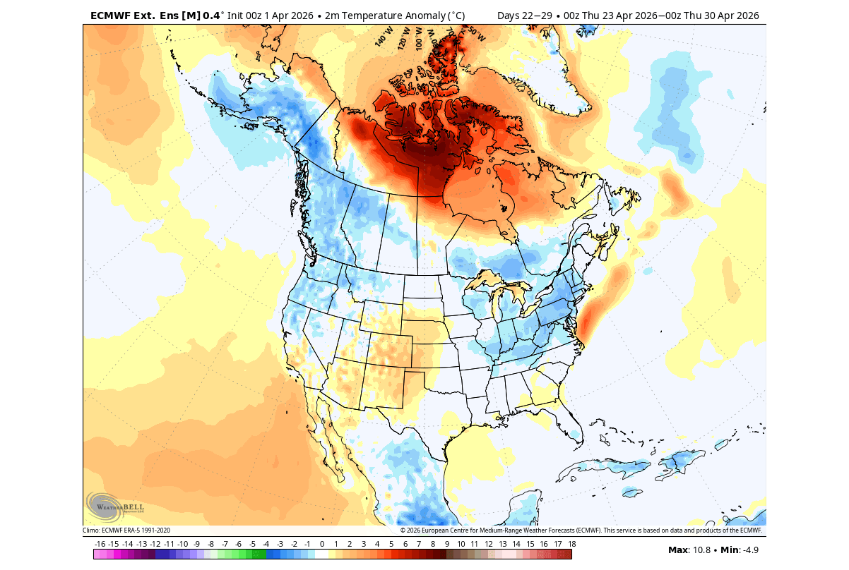
The temperature trend for this period shows a warm air anomaly over much of the United States and northern Canada. An exception is the growing trend of colder air spanning from western Canada towards the upper Midwest and the Great Lakes, and potentially into the northeast. Something to monitor over the next days.
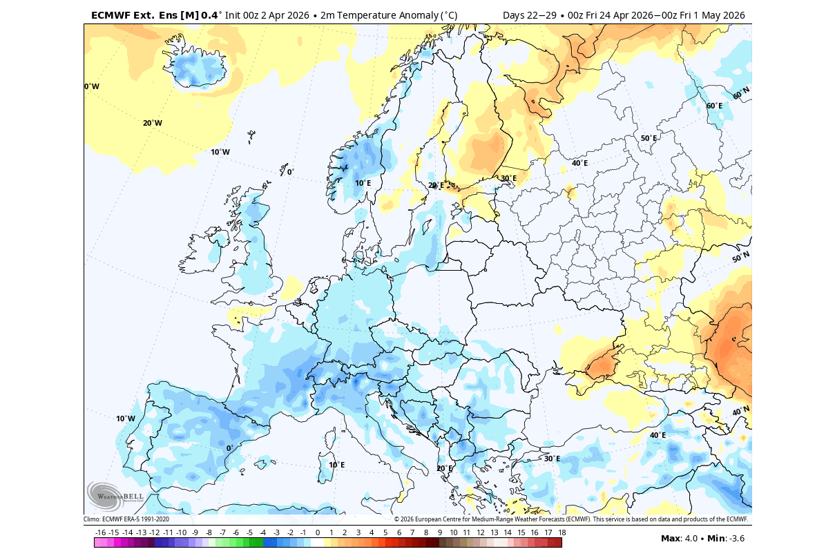
Over Europe, we can see the impact of the nearby low-pressure area over the Northwest. Warmer temperatures persist towards the north-central and northern parts, thanks to the high-pressure area. But normal to cooler temperatures are forecast over the southern, central, and western parts. But we also see the UK and Ireland under a cooler airmass.
The precipitation trend forecast below shows a rather “bland” pattern, due to the long lead time (week 3), but it still shows some useful indicators. You can see more precipitation over the Great Lakes and, to a lesser extent, the northeast. But less rainfall is expected over several areas of the United States, including the Plains and the East.
We do have to repeat that this is further out in the forecast period, so it serves as an example of a possible scenario.
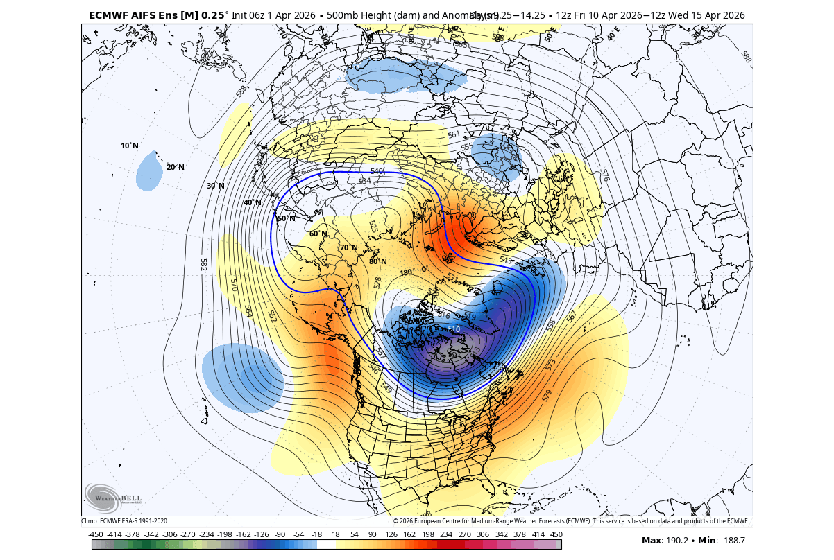
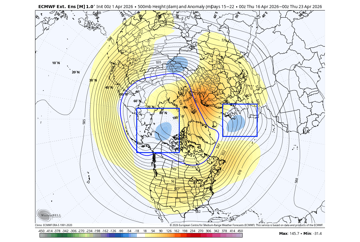
But going into the final stages of April, the pressure trend shows a high-pressure area over northern Canada, Greenland, and parts of northern Europe. We can actually see an indication of a potential low-pressure area over the northeastern United States and over the southwest. That would indicate a potential Omega Blocking development.
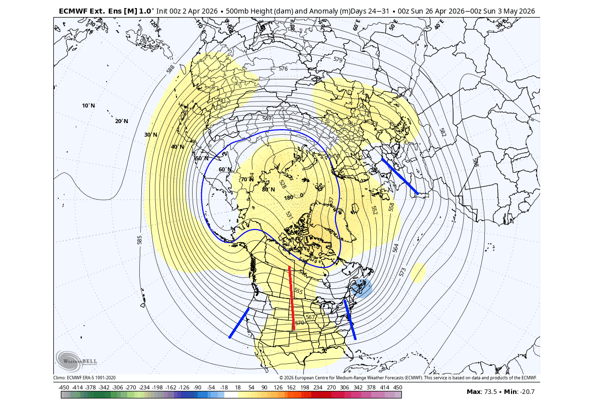
An omega blocking is basically a pressure pattern that resembles the Greek letter Omega, as seen in the NOAA example below. This usually means warmer weather under the main central high-pressure zone, while the two low-pressure areas can bring lower temperatures and unstable weather.
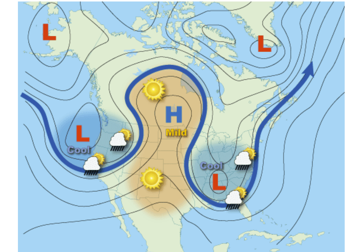
The temperature forecast for North America does show warmer central United States, under the high-pressure zone. But below-normal temperatures are trending back over the northeastern United States, the Midwest, the Pacific Northwest, and southern Canada.
Temperatures for this period over Europe show warmer anomalies in far northern parts, but a cooler tendency over the rest of the mainland. This is likely due to the visible low-pressure pattern at this range over Europe, bringing a more northerly cooler airmass, but a southerly warmer flow to the east.
This article is based on the latest available model/ensemble data, and we will continue to release weekly updates on this developing Polar Vortex situation.
We will keep you updated on the global weather pattern development, so don’t forget to bookmark our page. Also, if you have seen this article in the Google App (Discover) feed, click the like button (♥) there to see more of our forecasts and our latest articles on weather and nature in general.
The main forecast images in this article are from WeatherBell and weathermodels.com, using a commercial forecaster license.
Don’t miss: