It feels like warm waves are just not giving up over Europe yet. Another widespread blocking High intensifies over the continent this weekend into early next week, developing a powerful Heat Dome. With the surface pressure around 1045 mbar. Creating sharp temperature inversion under the dome of warm, dry air mass aloft. There are still no strong cold waves forecast, not before Christmas.
This weekend, a large blocking pattern developed across western and southern Europe, resulting in a significantly warmer and much drier air mass. Temperature is forecast to be much higher again, especially in elevated areas, while strong temperature inversion will engulf the lowlands.
This pattern will expand into the next week while the blocking high gradually expands across the Mediterranean region towards the southeast.
So, although December started with quite some wintry weather pattern, the weather charts flipped back into a much warmer phase, and it is not yet ready to cut the trends of the record-breaking month-by-month period since spring 2023.
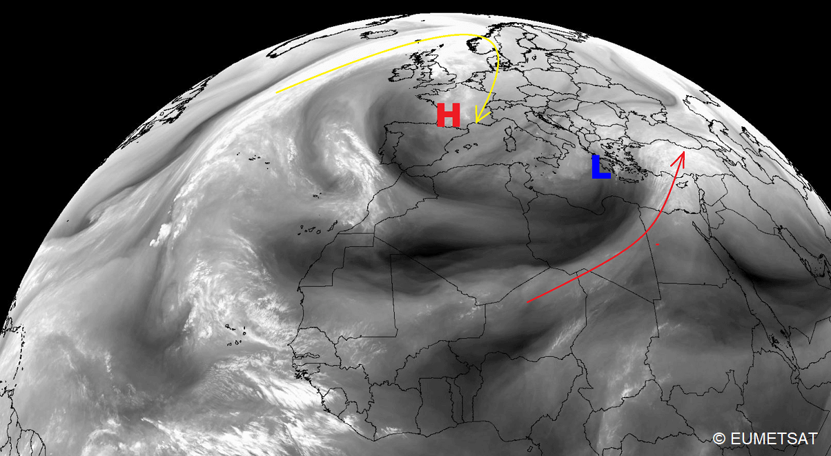
The water vapor satellite view over Europe and the North Atlantic reveals the developing High, with a departing upper low in the southern Mediterranean.
Before we go into details on the pattern evolution, the video below is a quick overview of what’s next for the European continent as we emerge into the second half of December.
The main reason behind the upcoming warm wave is a very powerful heat dome aloft. Generally, when a long period of stable weather is established, this well-known feature intensifies a warm wave (or a heat wave in summer months) underneath.
What is a Heat Dome, and Why Does It Bring Extreme Temperatures?
The Heat Dome was the primary background feature that caused the development of major heat waves and record-shattering warm periods globally every year. In 2023, there were particularly strong heatwave events during summer, which continued into September, October, and November.
This year, the number of record-breaking stations has gone into the thousands, and the temperature anomalies have often been off the charts. Just a few days ago, on December 12th, Spain set a new monthly all-time high-temperature record of +29.9 °C in Malaga.
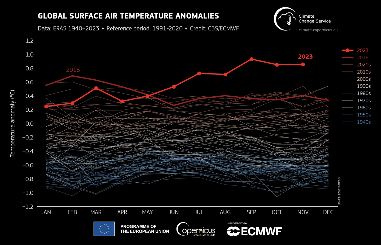
On a global scale, temperatures from June through November have also been significantly anomalous above pre-industrial levels. The chart below, provided by CopernicusEU, undoubtedly speaks for itself. According to the Copernicus Climate Change Service, November 2023 is the latest month where Earth’s average temperature has exceeded previous records.
This means that November is the sixth month in a row that smashed the previous record. This will lead to 2023 becoming the warmest year on record.
The Heat Dome is that feature that leads to these extreme heat events. Usually, the heat dome is the main and the most dominant feature of summer weather patterns in Europe and North America. And it can also occur in autumn and winter, as we are experiencing this year.
When extremely high and anomalous temperatures develop, we will use the term heat dome being used. Here is how it works and why it is important to understand it from a larger scale. The upper-level ridge pattern, or warm air mass in the higher altitudes, is the Upper High. Or, as we often call it, the blocking High. This High forms the heat dome.
So, this specific term is used when a broad area of high-pressure parks over a large portion of the continent. Normally, it stays there for several consecutive days or weeks if the event is particularly stable and extreme.
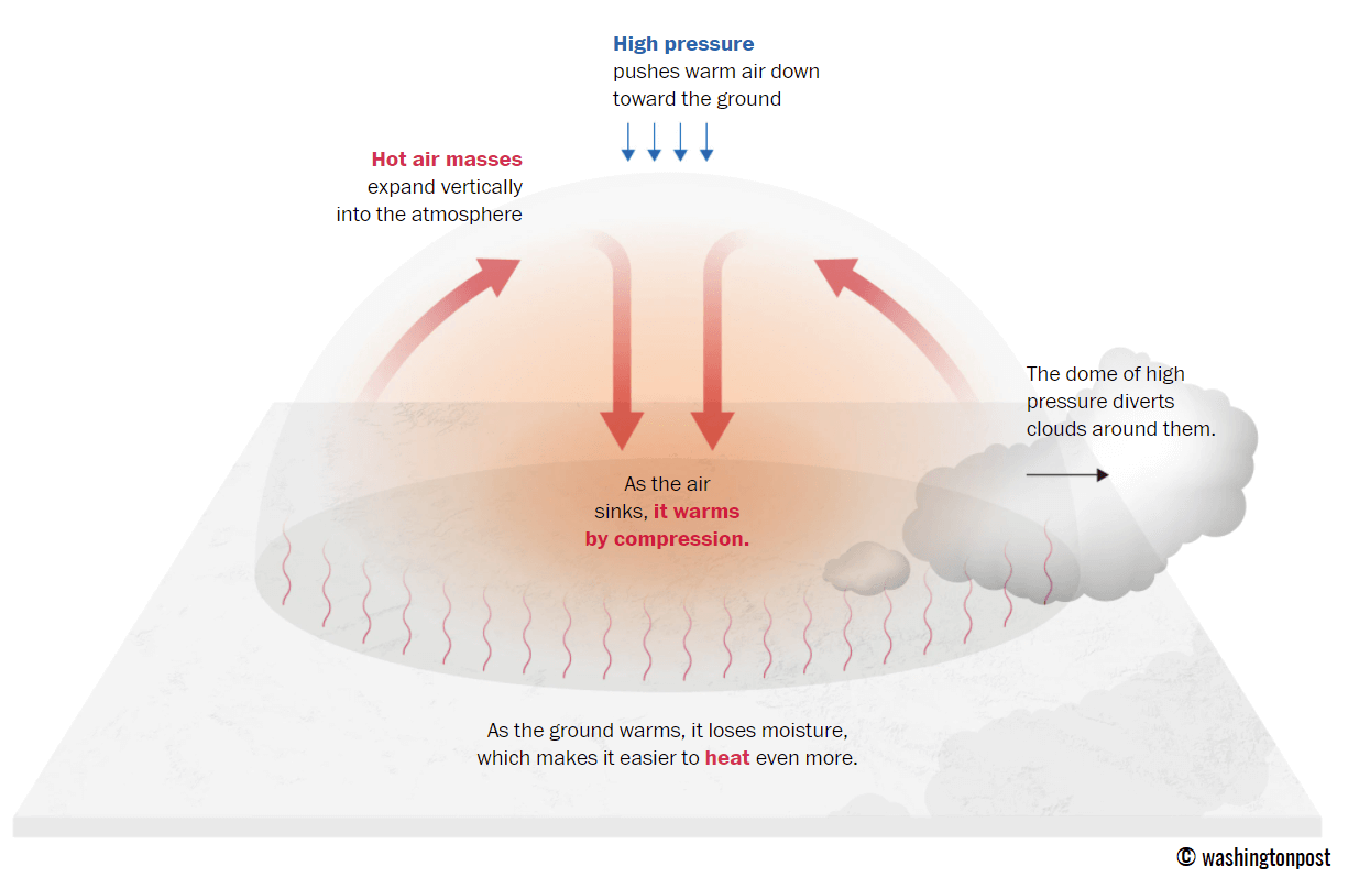
To better imagine how this feature works, the heat dome works like a lid on a pot. The extensive dome of heat traps a significantly warmer air mass at all levels underneath, sinking its layers toward the ground. Therefore, the air mass becomes dry and significantly warms as it reaches the lowest elevations of the atmosphere.
A warm or heat wave, associated with a heat dome, creates fair, stable weather and often arid air mass with minimal chances for precipitation or even clouds. This happens due to the sinking air parcels in the center of the heat dome, resulting in rising temperatures. Sometimes, we notice a specific weather pattern called the Omega blocking High.
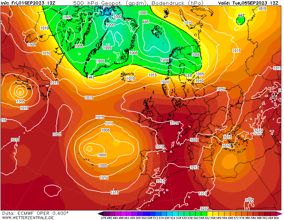
The example below is this kind of Omega blocking pattern over Europe from early September 2023. The omega-blocking pattern engulfs a large part of the continent, having a central heat dome and a low-pressure system on each side. One low was over the southern Mediterranean, and the other over the Azores.
Note that, especially during dry summer, drier and warmer weather produces a significantly enhanced wildfire threat due to developing drought. Or additionally worsening the ongoing, pre-existing, arid conditions. Such examples were wildfires in the Pacific Northwest and other parts of western North America in recent years or in Europe (Greece, Portugal, etc.) during this year’s summer season.
Heat dome is often also to blame for being responsible for deadly heatwaves worldwide. The scorching and excessive heat usually lasts for a very long period. Such heat dome events brought record temperatures in many countries worldwide in the summer of 2023, extending into the fall seasons.
Generally, the average and maximum temperatures under the heat dome are significantly above normal. When the dome of heat is particularly strong, it challenges existing historical records, as we have seen globally this year. This becomes particularly striking when this feature develops during early summer or autumn.
As mentioned earlier, the heat dome can develop in any season and normally leads to significantly anomalous temperatures underneath. It forms during the colder part of the year and brings strong temperature inversion. This means that cold air is trapped near the ground, e.g., in the valleys, while the layers just a few hundred meters above could have temperatures 10 to 15 °C higher.
A Massive Heat Dome Strengthens Over The European Continent
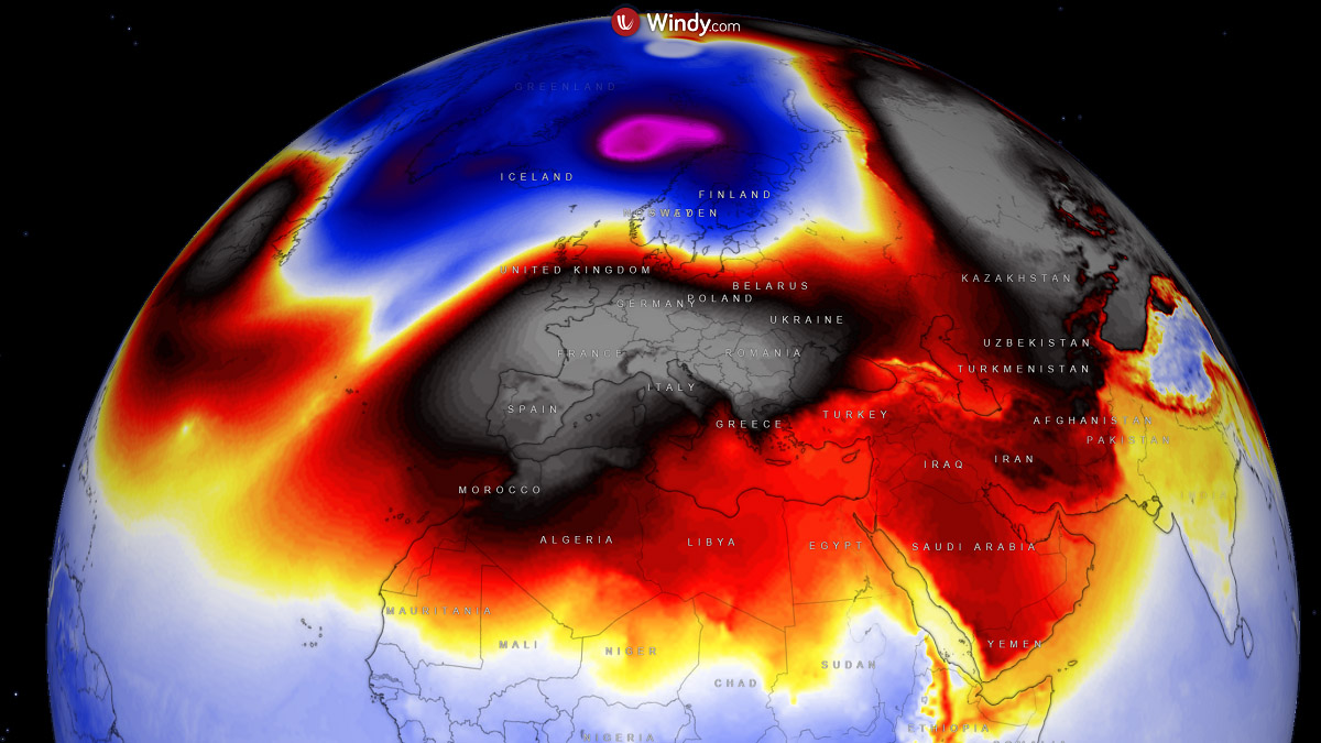
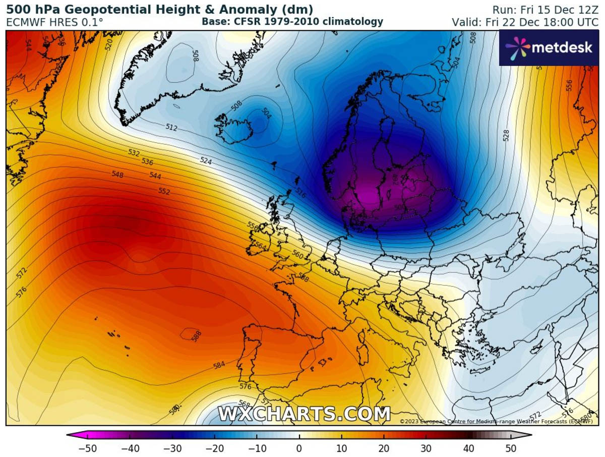
This weekend, the developing blocking high takes a higher gear and significantly strengthens the heat dome in Europe. The 500 mbar chart below represents the anomalies in higher altitudes.
The geopotential heights will be almost off the charts in the center of the High over Western Europe.
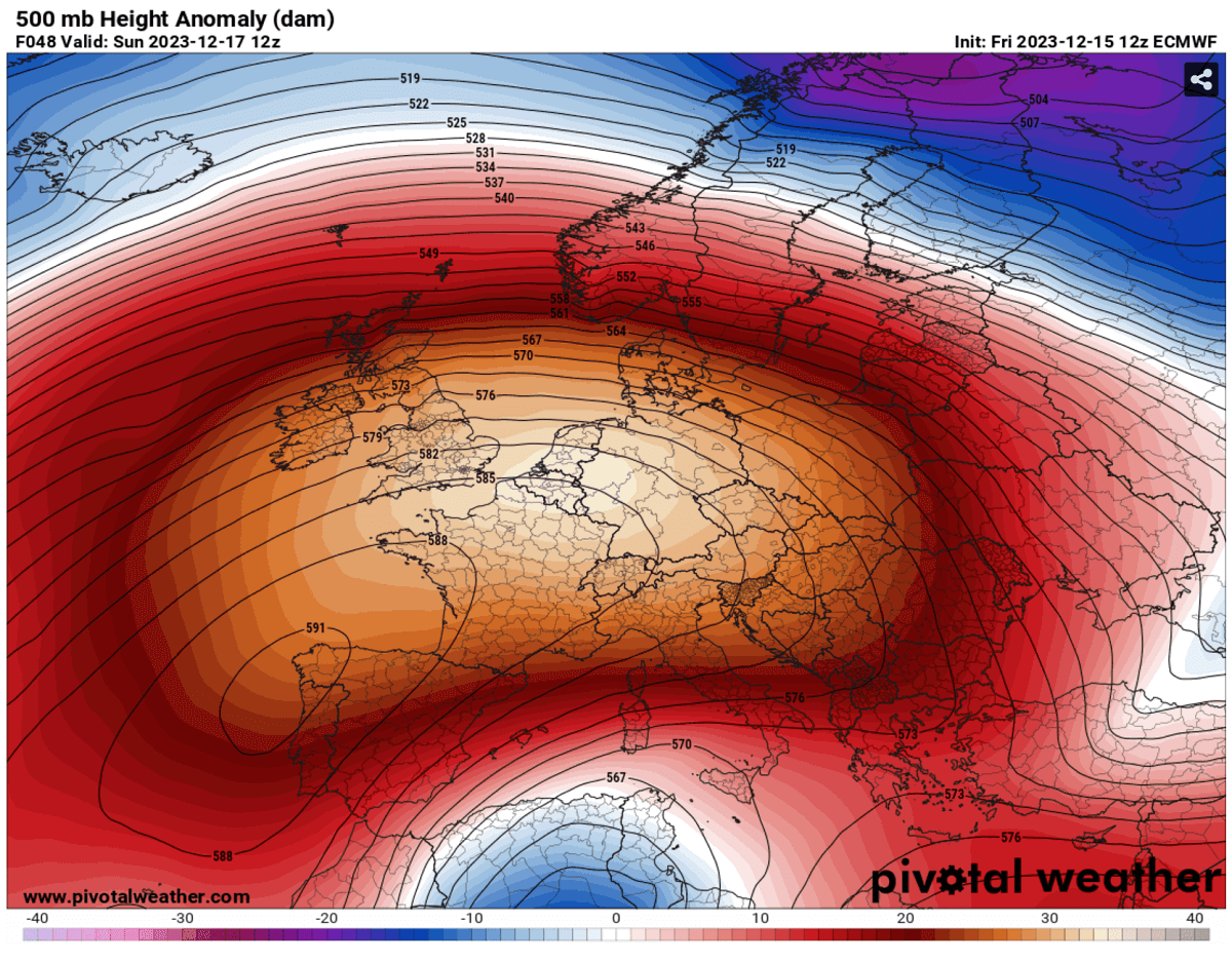
This creates a stable weather pattern, with no precipitation, as the blocking High and the associated surface-pressure system completely shut down the moisture accumulation underneath the dome aloft.
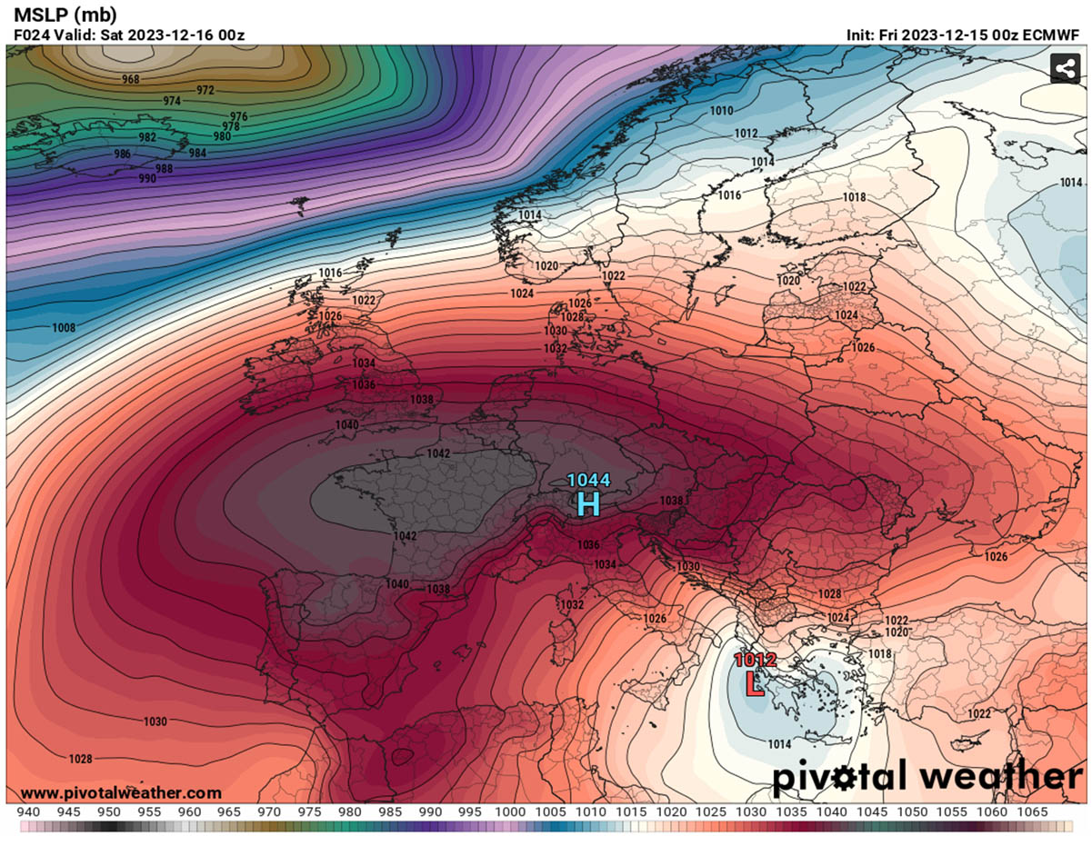
With descending air inside the dome, the surface pressure increases unusually. Weather model consensus is well-aligned for around 1045 mbar of central pressure across western and central Europe in the coming days.
The dry air also warms up from Saturday through Wednesday throughout all layers in the lowest few kilometers. But the stable weather, with a lack of winds to mix the air mass, also leads to a strong temperature inversion for the lowlands.
However, the areas above 500 m elevation and the layers immediately above it will experience much above-normal temperatures.
A strong warm wave occurs on Saturday through Sunday in western Europe first, then gradually expands east across central Europe.
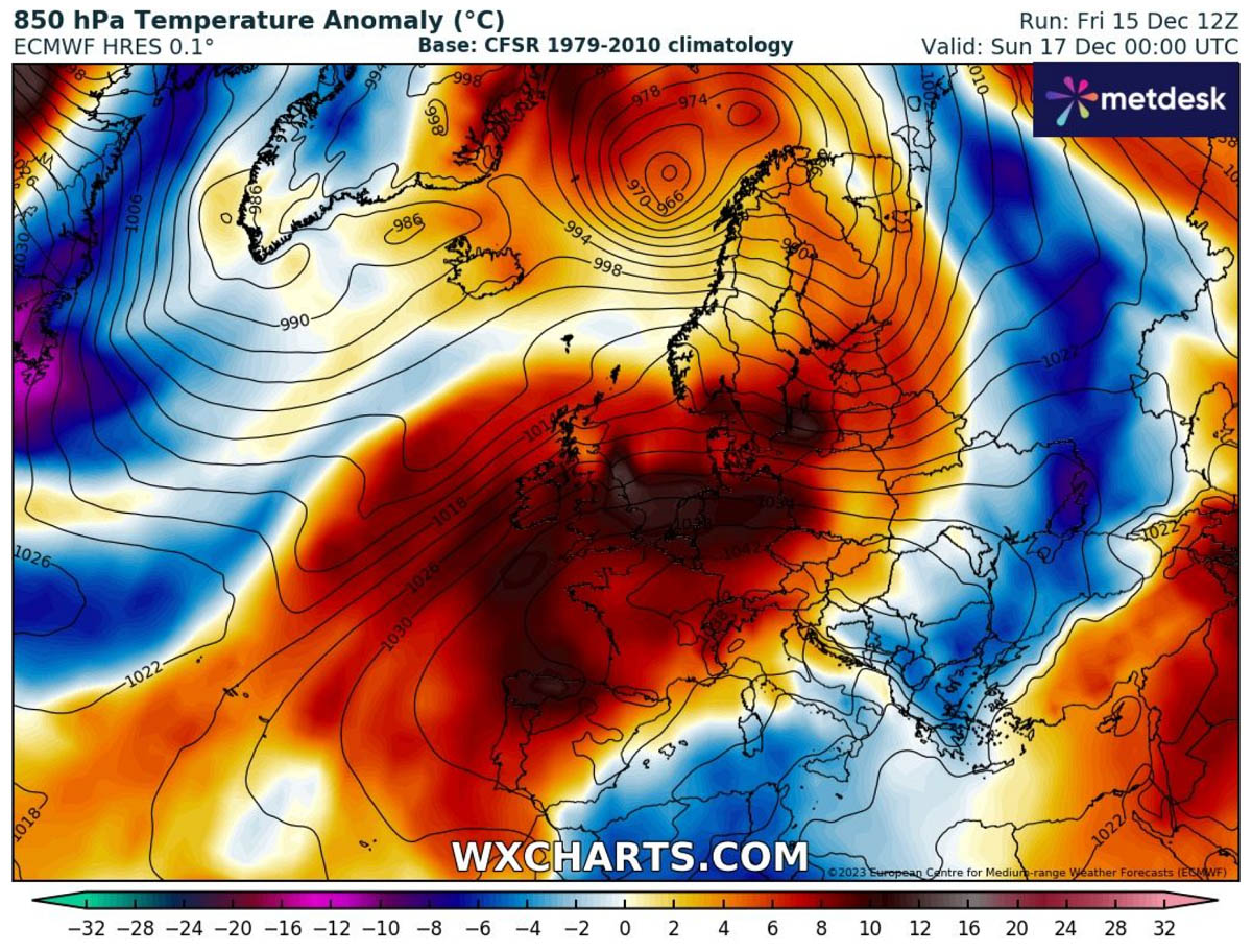
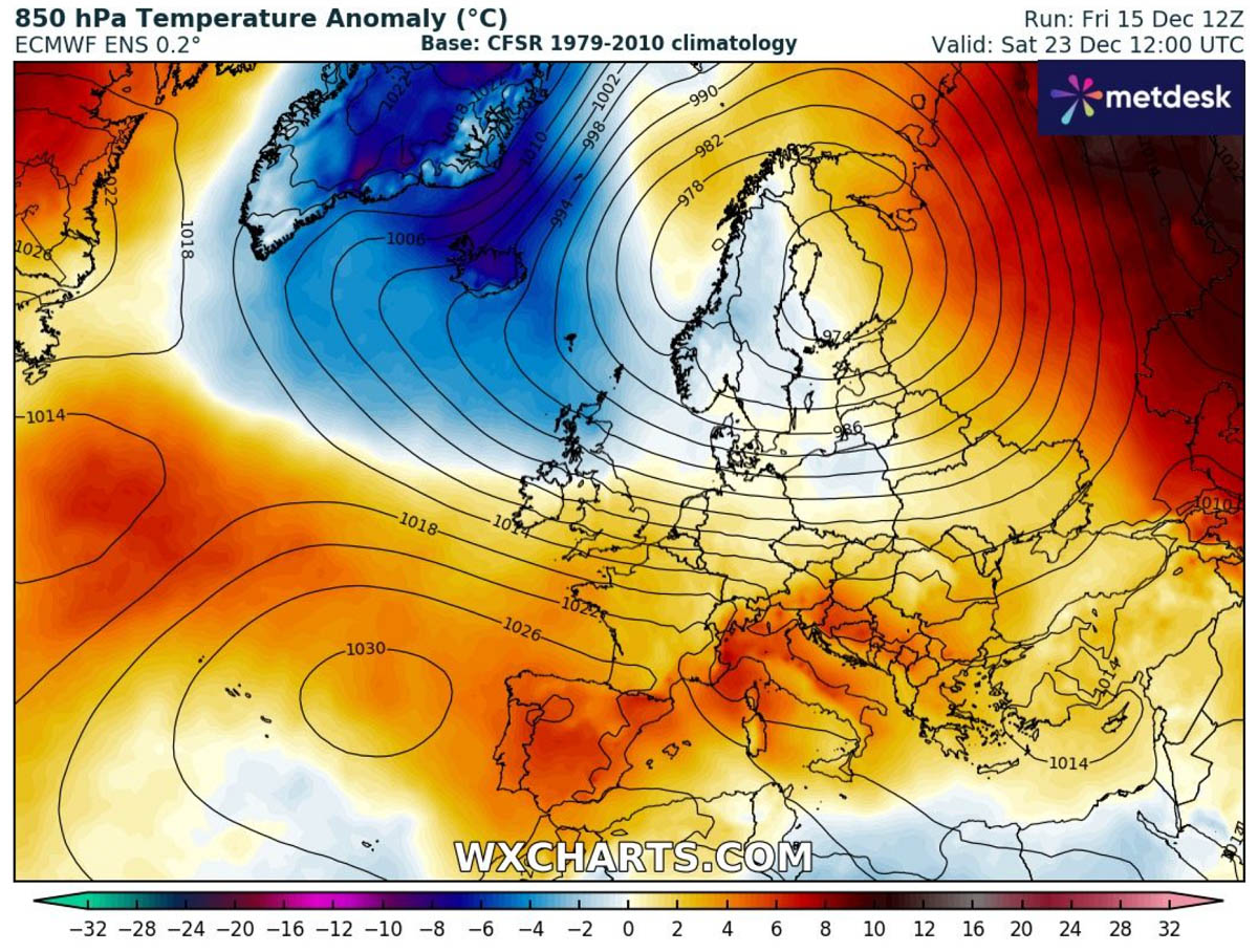
The following chart represents the temperature anomaly at the 850 mbar level. This is around 1200m above the sea level. 12-14 °C above long-term average, this is a significant heat dome.

We can see that the warm wave and strongly anomalous weather will spread Europe over the next few days.
Potential Challenging High Temperature for Mid-levels, but Strong Inversion and Colder for the Lowlands
The effects of blocking patterns and heat domes between summer and winter have one important difference. Stable, warm, dry air mass during summer brings extreme, scorching heat to the lowlands.
But during winter, a strong temperature inversion and a lack of near-surface flow result in weak or no winds not mixing the air masses. This leads to dense and cold air masses trapped underneath the dome of much warmer temperatures. Therefore, temperatures become warmer the higher we go, usually up to around 1500m above sea level.
A great presentation of how anomalous temperatures will be in the next chart below, the Meteogram for London, UK (left chart) and Ljubljana, Slovenia on the right. Both hint at unusually high temperatures at 850 mbar level, so approximately 1200 m ASL.
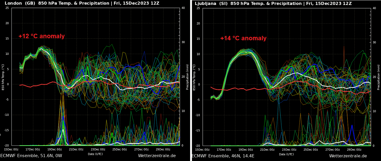
The chart also hints that no precipitation is foreseen at least until the 20th in the UK and even later across central Europe. Once the heat dome collapses around that date, a cold front will bring temperatures down quickly but will remain above normal.
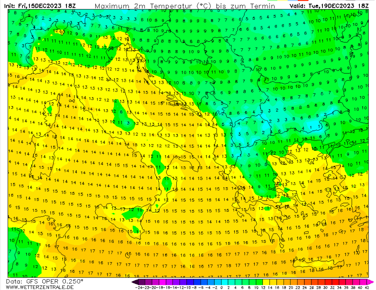
The following maximum temperature chart for the Mediterranean region on Tuesday hints at the inversion effects. We can see colder air across northern Italy’s plains (Po Valley) and over the flat inland of the Balkan peninsula. At the same time, higher elevations in Italy (Apennines) will have higher temperatures. Those will remain much higher than normal, especially during nighttime hours.
Below is another good example of this strong temperature inversion under the center of the heat dome aloft. The chart represents the temperature profile from the ground to the upper levels.
So the near-surface layers in southern Germany will have just a bit above 0 °C temperature, while layers a few 100s meters higher will have around ten °C.

The inversion, rising air temperature with height, will be significant.
Another Intense Blocking High Forecast over North Atlantic before Christmas, But Pattern Will Not Flip into Colder Phase Yet
The mid-range trends suggest that a strong dipole weather pattern will likely develop across the North Atlantic and Europe once this newly developed heat dome finally collapses towards next weekend.
The weather models agree that a powerful, high-pressure system will form over the North Atlantic, with its central pressure exceeding 1050 mbar.
Being positioned enough north in the Atlantic, it will allow some cold air intrusions from the Arctic region, at least into North-northwestern Europe. But until it expands further north, the zonal westerly flow will remain violent. Normally, it has to slow down significantly to get cold outbreaks further south over Europe.
There will be strong temperature and pressure contrast between the North Atlantic and Scandinavia, potentially even more than 80 mbar at the surface. We can see the tight pressure lines (or isotherms on the chart below) close together; this means a powerful jet stream between both large-scale features.
It will remain above normal and still unusually warm further south across central and southern Europe at least until Christmas, based on both GEFS and EPS ECMWF mid-range weather forecasts.
Stable and dry weather also means a lack of precipitation underneath the heat dome. So, expect mostly dry days until the next weekend. Lowlands will be trapped under a temperature inversion, having low cloudiness, high moisture, and foggy weather.

Strong westerlies will bring some precipitation, at least for the northern UK and western Scandinavia. And also across the south-southeast Mediterranean along the upper low moving east this weekend.
We will continue monitoring the evolution of future weather patterns over Europe and will keep you updated on any potential cold outbreaks and winter weather periods.
Wxcharts and Pivotalweather provided images used in this article.
See also: