As February slowly ends, the Polar Vortex disruption is triggering another explosive bomb cyclone, with a Nor’Easter Winter Storm Hernando unfolding off the U.S. East Coast on Monday. A rapidly deepening cyclone takes place as a powerful subtropical jet streak collides with a sharply displaced lobe of Arctic air diving south from Canada.
The result is the high-impact surface low undergoing rapid intensification, with central pressure forecast to fall more than 24 millibars in 24 hours. This is known as a bombogenesis meteorological process, or a bomb cyclone.
It appears likely that Hernando will bring violent winter weather across the Mid-Atlantic and the Northeast U.S. Severe winds exceeding 70 mph, blizzard conditions, coastal flooding, and severe travel disruptions are expected to occur where these conditions develop.
While the Mid-Atlantic states could see more heavy snowfall, blizzards, severe winds, and coastal flooding from a strengthening Nor’easter, the Southeast and Florida will face another sharp, intense cold, with Monday and Tuesday low temperatures below freezing as an Arctic air mass spreads deep south behind the Winter Storm.
The forthcoming Winter Storm Hernando will unleash the first blizzard in years across coastal areas and parts of the Interstate-95 corridor from near Philadelphia through New York City and Boston. The last time there was a blizzard warning in effect was during the winter storm from February 9th 2017.
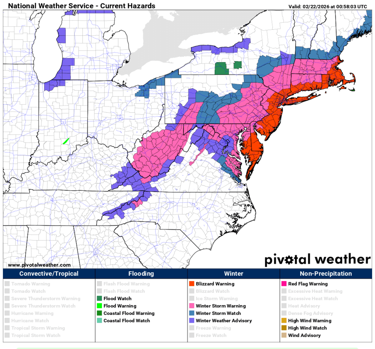
Winter Storm Warnings are in effect across the Mid-Atlantic to Northeast U.S. through Monday night. Blizzard warnings have been issued from Delaware to Connecticut, including all of New York City and Long Island.
The rapidly strengthening Nor’easter will create heavy snow and strong winds that threaten to shut down travel in a heavily populated, heavily traveled region of the nation.
A major coastal storm is expected to bring blizzard conditions, heavy snow, potentially damaging winds, and coastal flooding Sunday and Monday from the mid-Atlantic to New England. The surface low-pressure system is expected to rapidly intensify, meeting the criteria for a bomb cyclone by early Monday.
A deep low becomes a bomb cyclone when the low pressure intensifies rapidly, with more than 24 mbar pressure falls over a period of 24 hours.
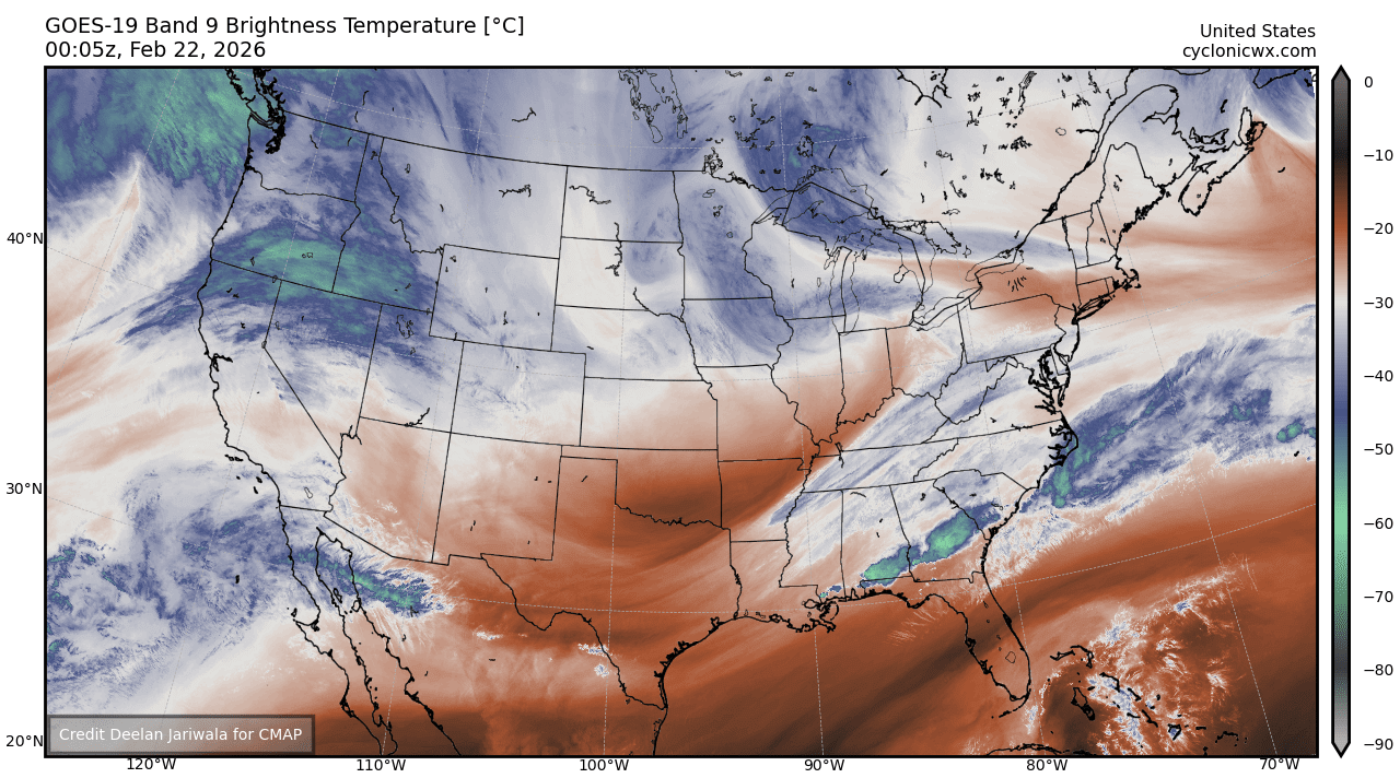
The latest water vapor satellite over the CONUS shows a deep upper low digging southward, releasing a new large cold pool of Arctic air. It is progressing southward and will soon clash with the subtropical air mass over the Gulf, triggering rapid cyclogenesis Sunday night. This storm will develop into a powerful Nor’Easter bomb cyclone, Hernando, on Monday.
Heavy snow with blizzard conditions is expected to develop across Washington, D.C., across New York City, and across Rhode Island to Boston as the storm intensifies.
The winter storm will produce widespread significant impacts across the Mid-Atlantic and Northeast
Sunday into Monday as a surface low rapidly intensifies off the Mid-Atlantic coast. Snowfall rates will exceed 1 inch per hour at times, with snowfall totals up to 2 feet, resulting in near-impossible travel conditions and significant delays.
The combination of heavy snowfall and strong winds will result in blizzard conditions along coastal areas from Delaware through southeastern New England. The wind gusts of 40-70 mph are expected from coastal New Jersey into southeast New England.
These strong winds, combined with the weight of heavy, wet snow, will likely result in scattered to numerous power outages. Snow will continue over the Northeast/Northern Mid-Atlantic through Monday evening.
Before we dig into the details of the impactful new Winter Storm Hernando, associated with the explosive Nor’Easter bomb cyclone, it is essential to understand the background mechanisms governing the Polar Vortex.
Note that this is the primary driver of rapid weather changes and intense Arctic outbreaks across Canada and the United States during winter, bringing extreme cold deep into the South, toward the Gulf Coast.
What is the Polar Vortex?
The Earth’s atmosphere has six layers. Most of the dynamics of our daily weather occur in the lowest two layers of the atmosphere, the troposphere and the stratosphere.
The troposphere is the layer closest to the Earth’s surface. It is about 12 km deep and extends from the ground up high into the sky. Depending on where you live, its depth varies from around 8 km to almost 20 km. The troposphere is deepest over the equatorial region and becomes much thinner over the North and South poles.
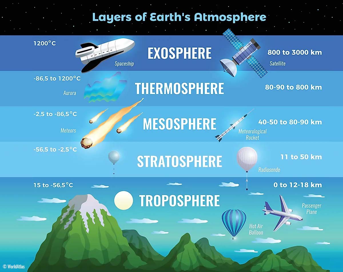
Above this layer is a much deeper one known as the Stratosphere, an 11-50 km thick layer of arid air. Another essential feature in the stratosphere, which makes our weather even more variable, often triggers significant, large-scale, long-lasting winter weather events.
This is the Polar Vortex—an enormous, tri-dimensional ring of powerful winds moving through the sky above us. The Polar Vortex is spinning around the North Pole, grazing through the air at about 20-50 km above the Earth’s surface with violent wind speeds.
How and when does the Polar Vortex form?
Due to the Earth’s inclination, the polar regions receive much less energy from the Sun during the fall months. This makes the cooling over the northern areas more robust. As a result, polar nights can last several consecutive months, followed by days without sunlight.
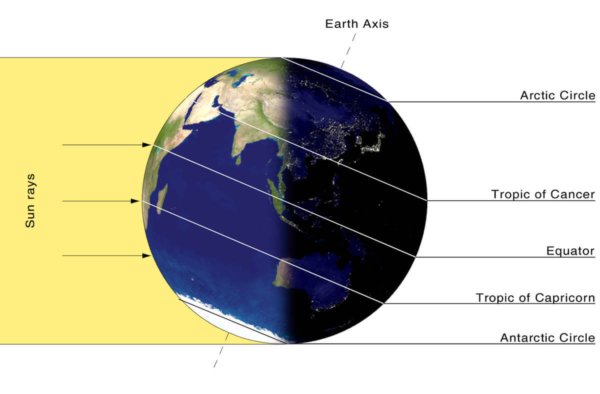
While temperatures in the polar regions are dropping into a deep freeze, the atmospheric layers farther to the south are still relatively warm because they receive more of the Sun’s energy at the same time. Therefore, the south’s equatorial layers remain much warmer than the areas farther north, leading to a high-temperature contrast.
Cooling the polar regions also lowers the ambient surface pressure, and a similar weather process occurs in the stratosphere. The temperature difference between the North Pole and the equatorial areas increases across both layers.
This creates a large, low-pressure cyclonic circulation across the polar stratosphere, which gives it its famous name—the Polar Vortex.
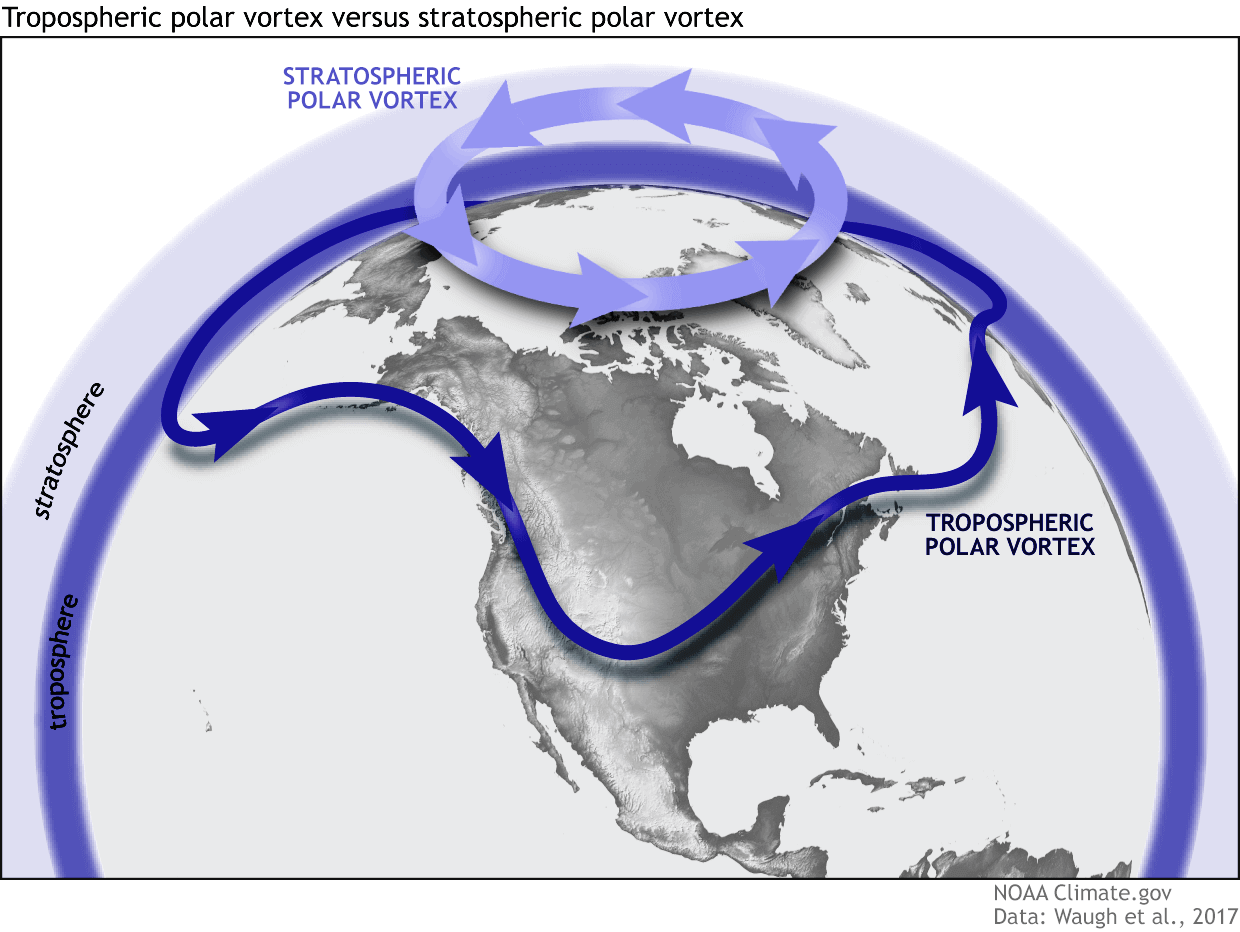
As shown in the image above, we monitor two atmospheric layers during wintertime: the troposphere and the stratosphere. The first is the lowest layer, and the second is at a higher altitude. The Polar Vortex rises through both layers, but with different strengths, shapes, and impacts.
For this reason, we separate the entire Polar Vortex into an upper (stratospheric) and a lower (tropospheric) part. When the Polar Vortex is strong, it traps colder air in the polar regions, preventing its escape and creating milder conditions for most of the United States, Europe, and other mid-latitudes.
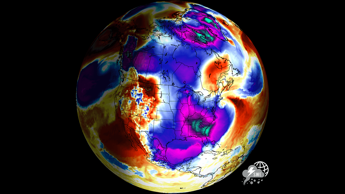
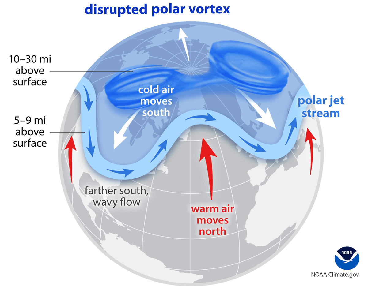
But when the Polar Vortex gets disrupted or even entirely collapses, it can’t fully contain the cold air, which can now easily escape from the polar regions into the United States or other mid-latitude regions. Below is an example of how a disrupted Polar Vortex brings cold polar air into the United States and Europe.
We have experienced this in Asia, Canada, the U.S., and sometimes Europe in recent years. The vortex aloft has been significantly disrupted this season, and when its lobe shifts away from the North Pole, the extreme cold grips the North American continent.
A deep upper core digs into the Southeast U.S. and East Coast on Monday
The significant disruption of the Polar Vortex remains underway and is sending another cold Arctic intrusion far south across North America, with one blasting into the Southeast U.S. by Monday.
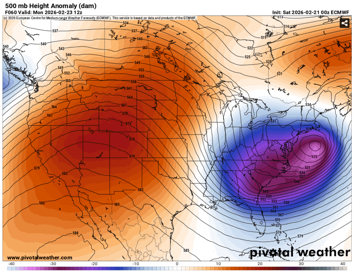
The new wave leads to a major displacement of the polar jet stream, with its winds digging deep south into the Gulf region as the strong blocking High persists over the western CONUS.
An amplified jet stream follows after the collision with the subtropical air masses, developing violent winds in the upper levels.
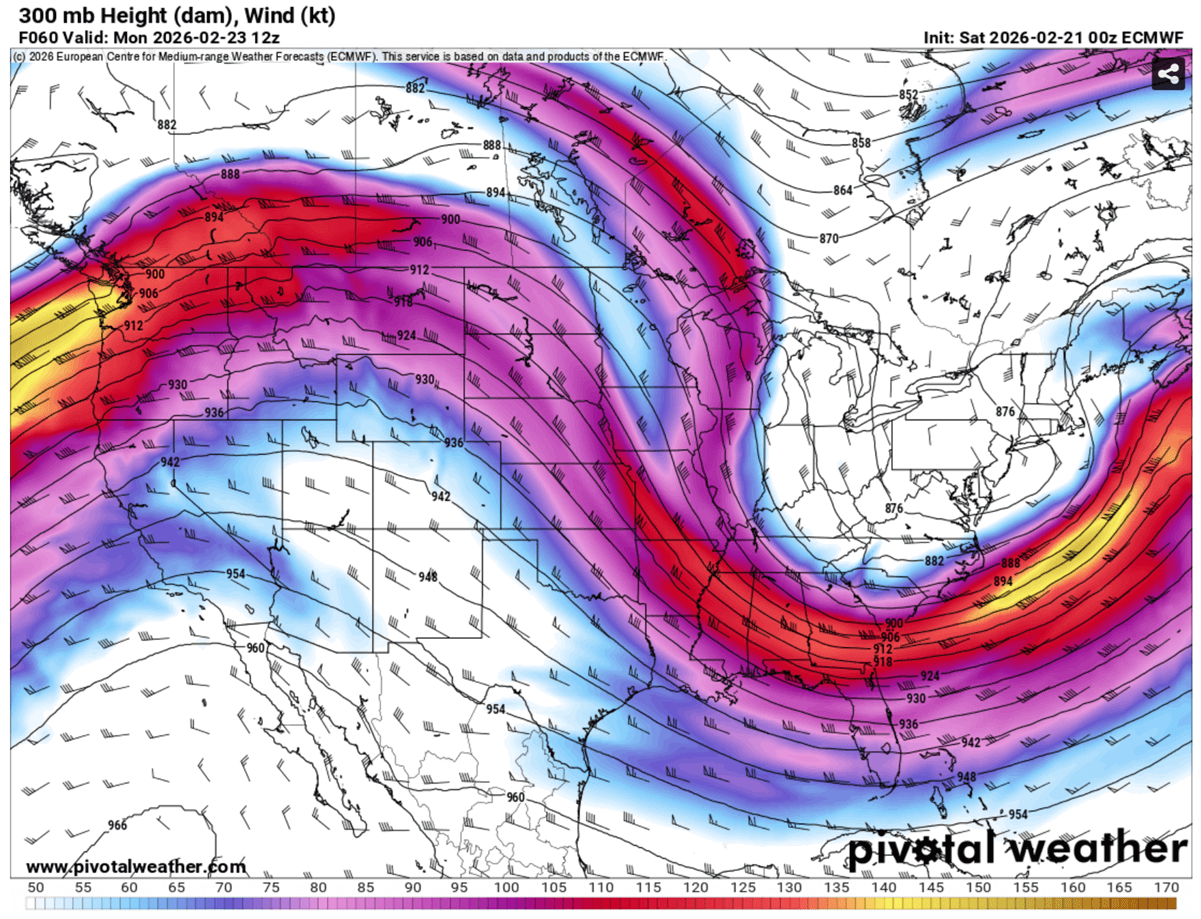
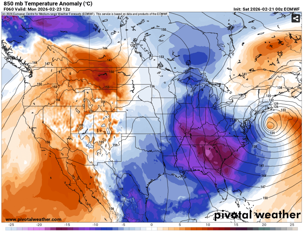
It helps drag the Arctic cold air masses far south, spreading across the Southeast and the Gulf Coast on Sunday into early next week.
Temperatures will be extremely low across the region late Monday, with 20-30 °F below normal in the Tennessee Valley, Mississippi, Alabama, Georgia, and Florida.
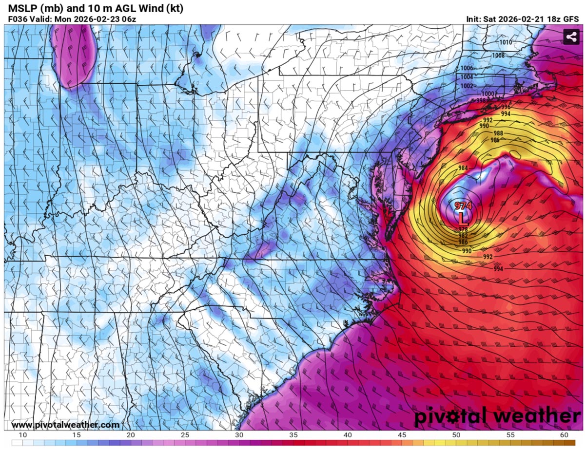
The amplified jet stream results from the clash of Arctic cold with warmer subtropical air masses, leading to the explosive development of a surface low off the Southeast coast. A bombogenesis Nor’Easter storm, Hernando, occurs, with a rapid pressure drop as the low strengthens along the East Coast.
The cold pool over the eastern two-thirds of the country raises surface pressure, creating a strong pressure gradient with the deepening low over the Atlantic coast. High pressure spreads across the CONUS while a deep low emerges over the Mid-Atlantic and the Northeast U.S.
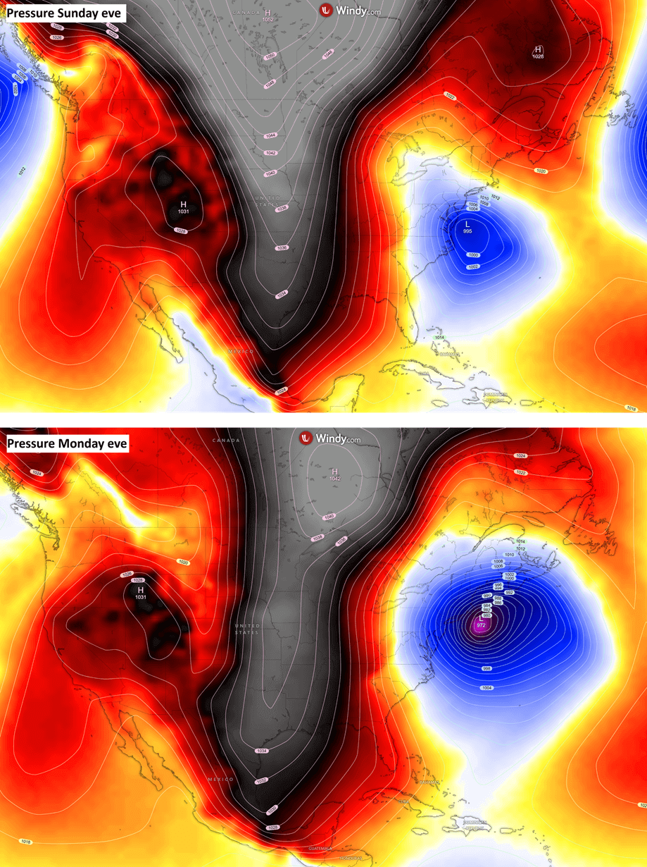
This will increase the wind field from the East Coast and the Mid-Atlantic states to the Northeast U.S. and to Nova Scotia, Canada. Leading to blowing snow and, in case of new snowfall, also violent blizzard conditions and whiteouts.
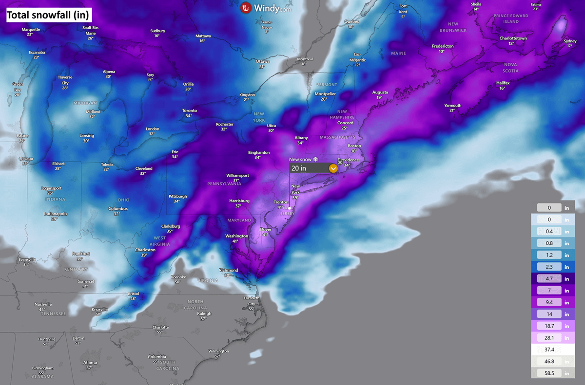
Nor’Easter brings major snow and intense blizzard conditions from New York City to Boston
The Hernando storm’s track on Sunday night into Monday will bring highly impactful snow and blizzard conditions. The general weather model consensus suggests an impact from a significant snowstorm from Washington, D.C., across New York City to Boston on Monday.
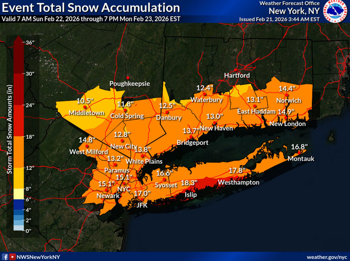
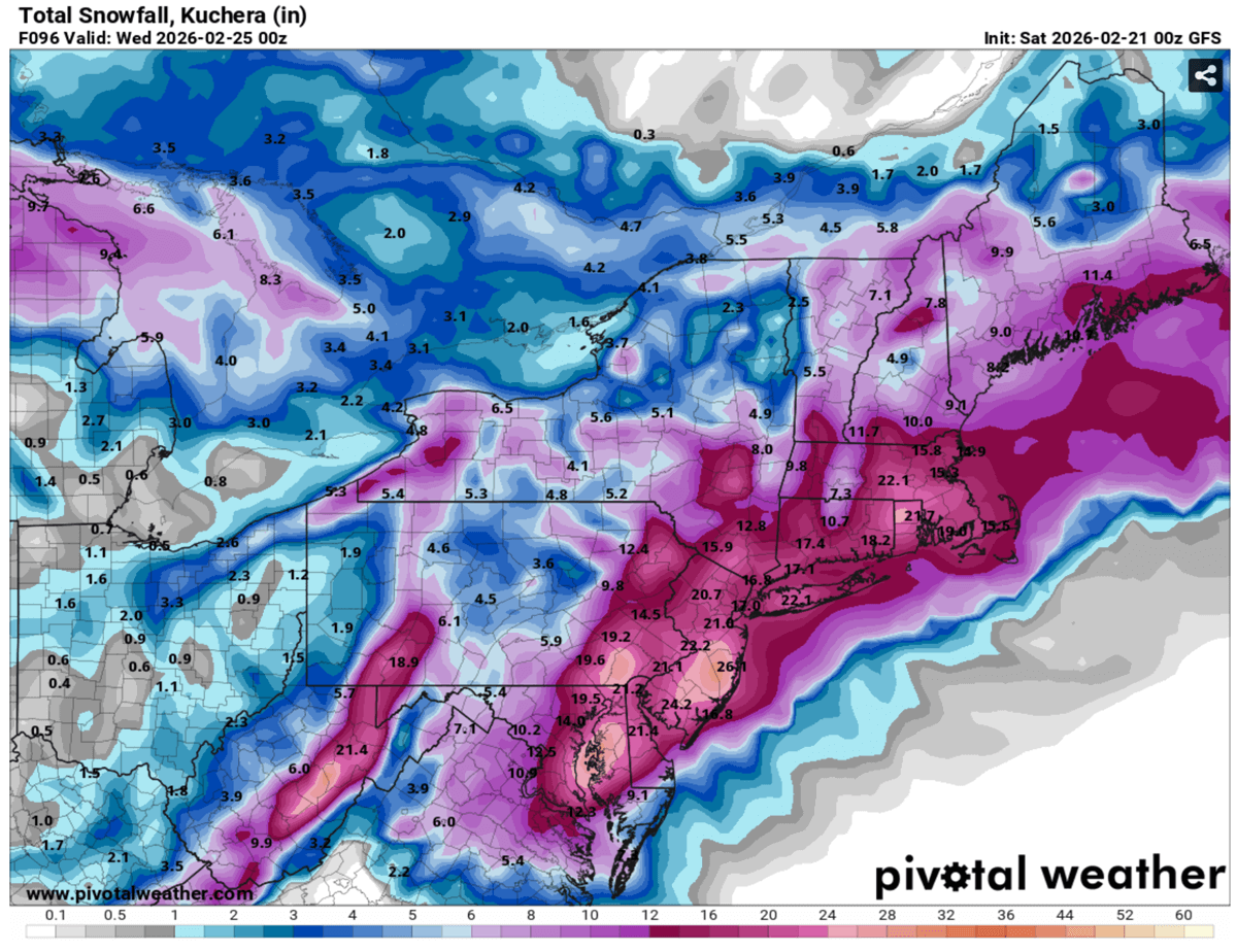
The following snowfall chart from the GFS model hints at where the snowstorm’s worst impact could be. It should be noted that it all depends on how close to the East Coast the core of the bomb cyclone Nor’Easter passes. The further west it goes, the more significant the impact will be.
The chart suggests that New York, New Jersey, and Massachusetts will be in the direct path of a violent winter storm, Hernando. Deep snow will blanket Washington, D.C., New York City, Rhode Island, and Boston with 1-2 feet of snow on Monday.
Similar to the experiences from the storm Gianna, the more concerning aspect is the strength of the near-surface winds, as the pressure and temperature difference between the center low and the East US Coast will be extreme. This should result in particularly severe winds.
Although the exact position of the low is still uncertain, the closer the low sits to the coast, the more violent the winds will be, damaging trees and infrastructure.
Combined with heavy snow, severe blizzard conditions would result in major travel disruptions, whiteout conditions, high snow drifts, and major delays. Including more flight cancellations.
Another intense cold blast brings extreme cold into the Southeast and Florida
The disrupted Polar Vortex aloft sends the cold very far south across North America, spreading extreme cold across the Southeast U.S., including the Gulf Coast and Florida, on Sunday night into Monday, and again on Tuesday. Morning lows on Monday and Tuesday will be significantly lower than usual for tens of million people across the Central, East and Southest U.S..
The Monday morning temperatures will be in the single digits and below 0 °F across the Dakotas, the Midwest, and the Upper Midwest. Temperatures will be in the tens to mid-20s for the rest, upper 20s to low 30s from central Texas to Alabama and Georgia, andon Monday morning.
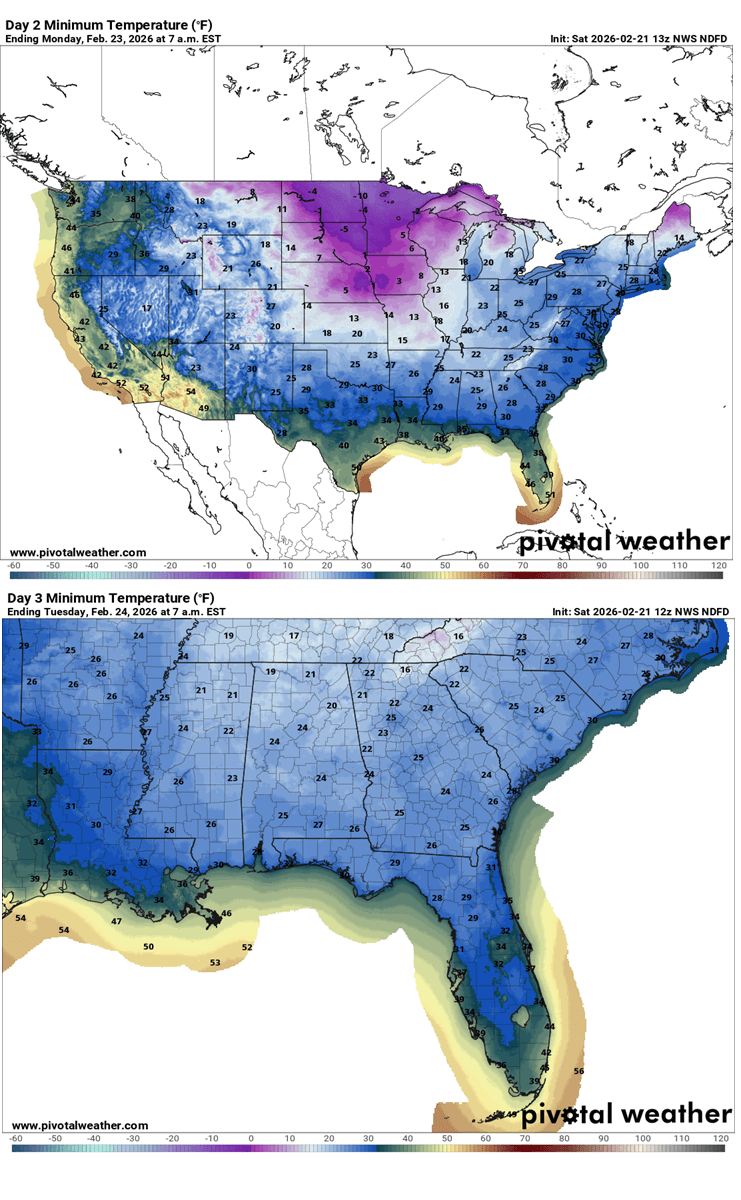
A closer look across the Southeast U.S. for Tuesday morning suggests the cold will be particularly extreme again, with freezing temperatures also expected along the Gulf Coast and down to central Florida. Morning lows will reach the low 30s in central and interior South Florida.
To conclude, the upcoming new wave of the Arctic cold blast will again be quite intense for the Southeast U.S. It will trigger a violent bomb cyclone, acting as a Nor’Easter winter storm, hitting Hernando off the East Coast, and result in intense blizzards and heavy snow with severe winds from NYC and Rhode Island to Boston.
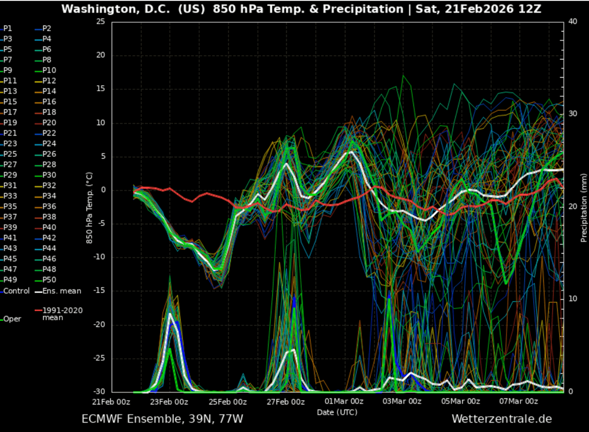
The cold across the Southeast U.S. will be brief but intense. The following chart shows the temperature forecast for Washington, D.C.. We can see that the cold pool will be short but intense with dynamic trends to continue through the remainder of the month.
As we head into the end of February and meteorological spring arrives soon, we will continue monitoring the ongoing progressive and active weather pattern across Canada and the United States. The potential SSW with the collapsing Polar Vortex aloft is likely to trigger more extreme cold outbreaks and winter storms with deep snow across North America in the coming weeks.
Stay tuned for further updates.
Windy, PivotalWeather, and Wxcharts provided images used in this article.
See also: