The disruption of the Polar Vortex has led to its split. It is now forecast to send extreme, frigid Arctic air across Alaska, Canada, and parts of the Contiguous United States towards the following weekend. Temperatures will plunge into a deep freeze, with multiple snowstorms racing across the northern U.S.
The so-called “Polar Express” weather pattern is establishing across the North American continent, meaning we have consecutive cold-air outbreaks that grip Canada and the U.S., bringing extreme cold.
Thanks to the Polar Vortex’s southern lobe gradually shifting into the American side of the Northern Hemisphere, the brutal cold will first spread into Alaska and the Yukon, Canada, then across the prairies into the eastern two-thirds of the United States.
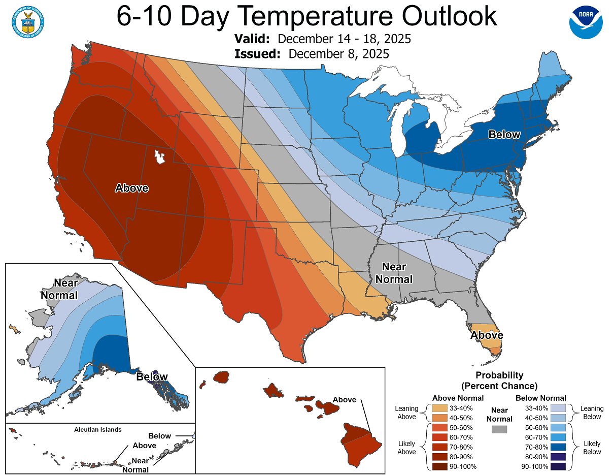
The temperature outlook, published by NOAA, for the 5-10 day period hints at above-normal temperatures in the West and below-normal temperatures in the East, including Alaska.
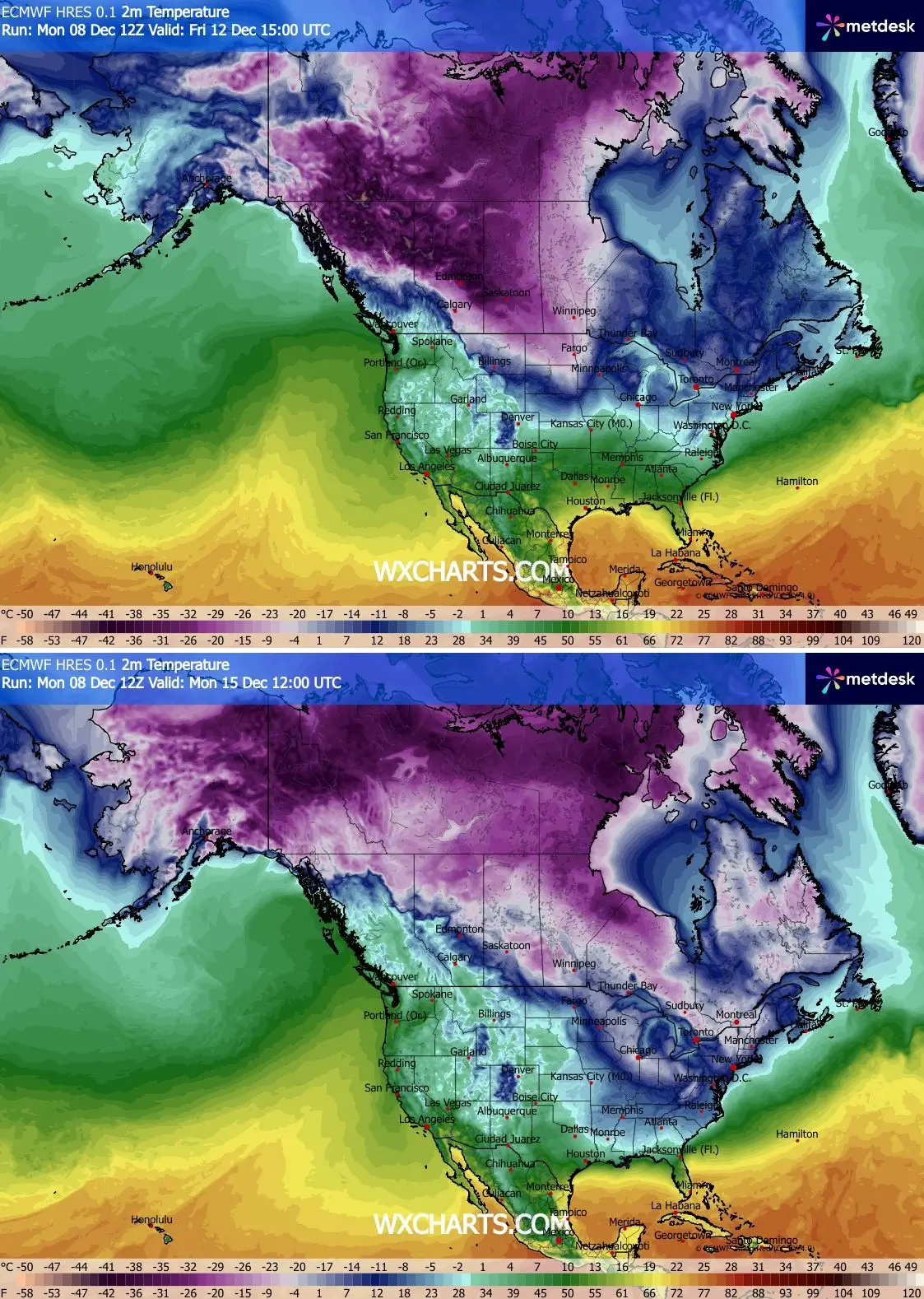
This means that the average temperatures through mid-December, so from late this week through the weekend and into next week, will be well below normal across Alaska, much of Canada, and the eastern two-thirds of the U.S.
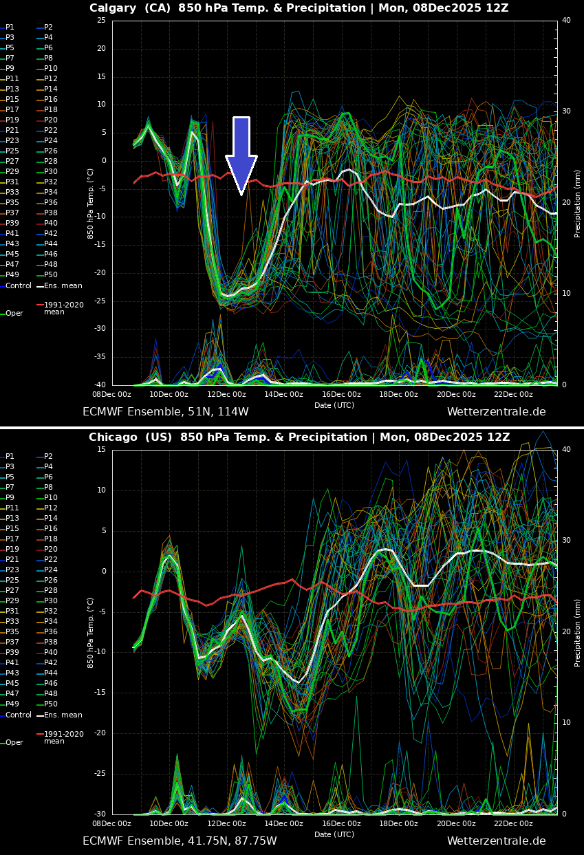
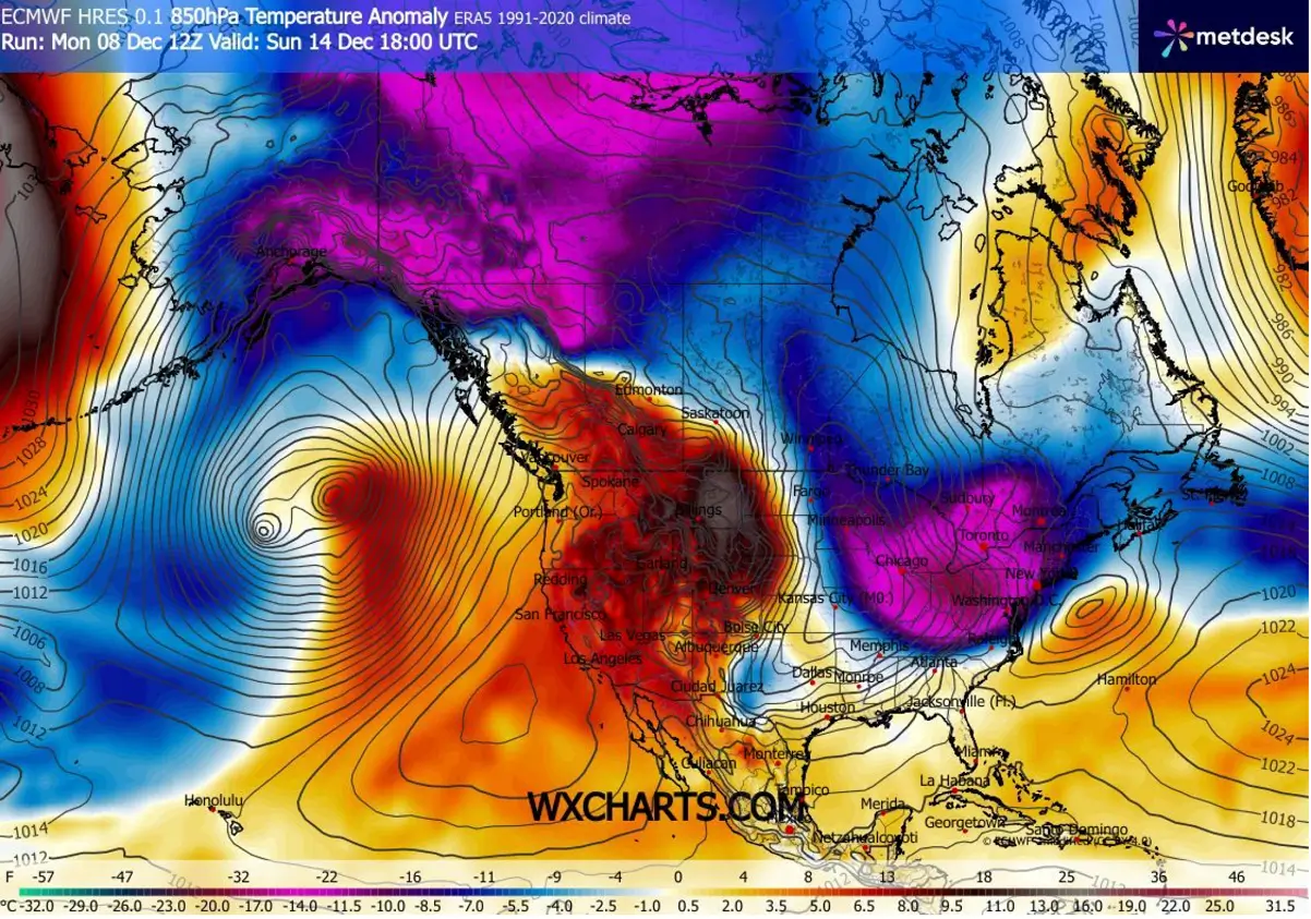
How intense the weather pattern, dynamic, and frigid cold outbreaks will develop is best represented by temperature anomalies. We use meteogram charts for several cities to observe rapid, extreme weather changes.
The following comparison for Calgary, Canada, and Chicago, Illinois, indicates the most frigid cold air mass arrives towards the weekend. In Calgary, the temperature will drop by more than 30 °C in 24 hours, from +5 °C on Thursday to -25 °C on Friday.
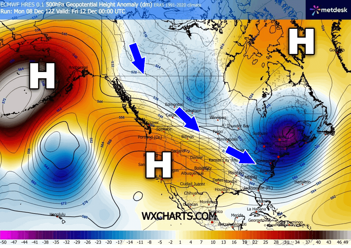
Let’s take a quick look at how impressive the pattern and temperature dynamics are forecast to be over the next 10 days. We can see the blocking on the west and troughs on the east.
Followed by intense cold outbreaks and occasional fast-moving winter storms to deliver snow across southern Canada into the Dakotas, Upper Midwest, and across the Great Lakes to the Northeast U.S.
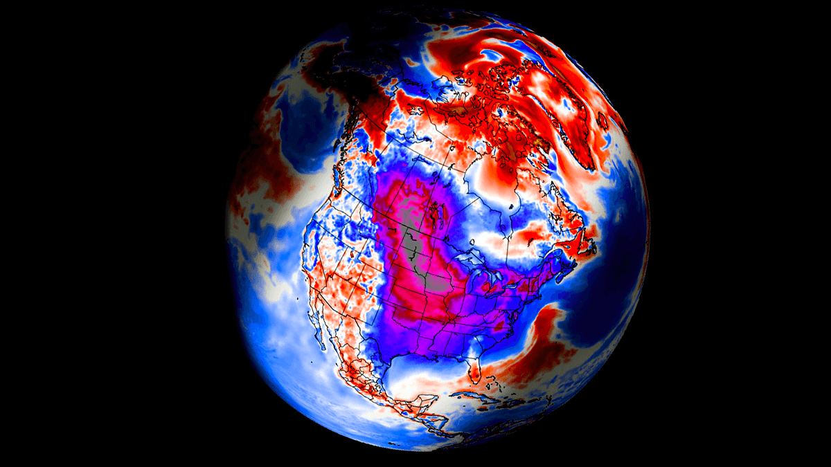
Following the unusually early Polar Vortex split this month, its southern lobe shifted over North America. Allowing the cold air mass outbreak to push far south from Canada into the United States. First, let’s examine what this feature is and why it is essential to understand its mechanism.
What is the Polar Vortex?
The Earth’s atmosphere has six layers. Most of the dynamics for our daily weather occur in the lowest two layers, known as the troposphere and the stratosphere.
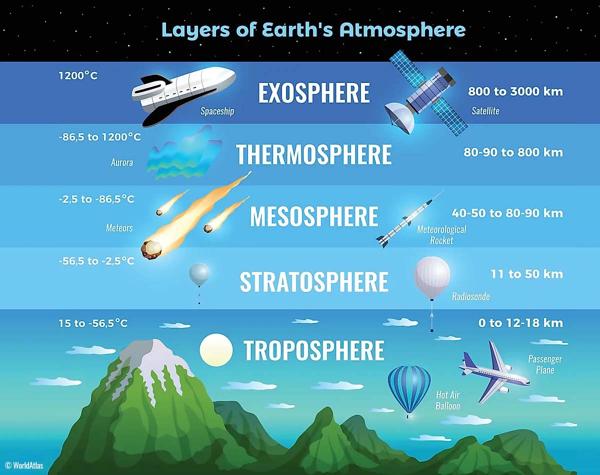
The troposphere is the layer closest to the Earth’s surface. It is about 12 km deep and extends from the ground up high into the sky. Depending on where you live, its depth varies from around 8 km to almost 20 km. The troposphere is deepest over the equatorial region and becomes much thinner over the North and South poles.
Above this layer is a much deeper one known as the Stratosphere, an 11-50 km thick layer of arid air. Another essential feature in the stratosphere, which makes our weather even more variable, often triggers significant, large-scale, long-lasting winter weather events.
This is the Polar Vortex—an enormous, tri-dimensional ring of powerful winds moving through the sky above us. The Polar Vortex is spinning around the North Pole, grazing through the air at about 20-50 km above the Earth’s surface with violent wind speeds.
The troposphere and stratosphere are crucial for our climate. The Polar Vortex covers most of the bottom half of the atmosphere. Since the vortex extends from the middle of Earth’s troposphere into the stratosphere layer, it significantly affects winter weather across high and mid-latitudes yearly.
The Polar Vortex is most substantial during winter in the Northern and Southern Hemispheres. Although it spins well above our heads, it remains closely connected with the lowest parts of our atmosphere. Thus, it influences our daily weather in many ways, functioning as a sizable hemispheric circulation.
The Polar Vortex has triggered some of the most intense weather systems, from frigid cold outbreaks and winter storms in Canada and the United States to those across Asia and Europe. Although it affects the entire Northern Hemisphere, its main impact occurs where the vortex’s southern lobe is located.
How and when does the Polar Vortex form?
Due to the Earth’s inclination, the polar regions receive much less energy from the Sun during the fall months. This makes the cooling over the northern areas more robust. As a result, polar nights can last several consecutive months, followed by days without sunlight.
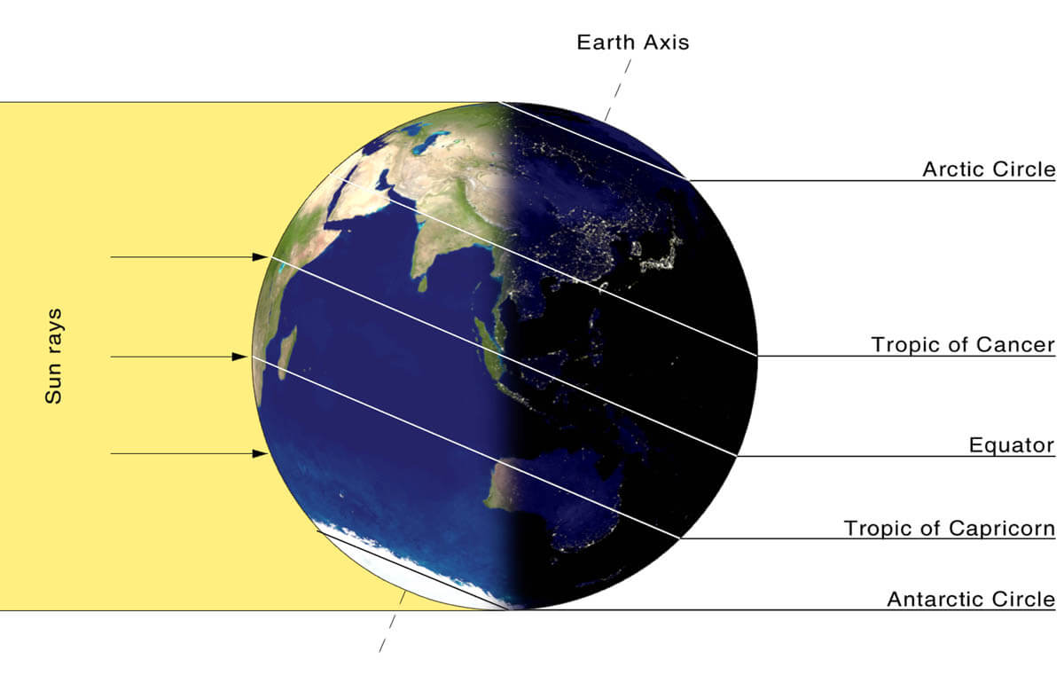
While temperatures in the polar regions are dropping into a deep freeze, the atmospheric layers farther to the south are still relatively warm because they receive more of the Sun’s energy at the same time. Therefore, the south’s equatorial layers remain much warmer than the areas farther north, leading to a high-temperature contrast.
Cooling the polar regions also lowers the ambient surface pressure, and a similar weather process occurs in the stratosphere. The temperature difference between the North Pole and the equatorial areas increases across both layers.
This creates a large, low-pressure cyclonic circulation across the polar stratosphere, where it takes its famous name—the Polar Vortex.
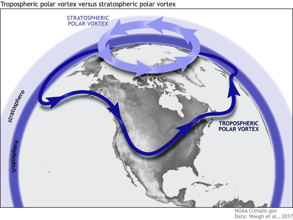
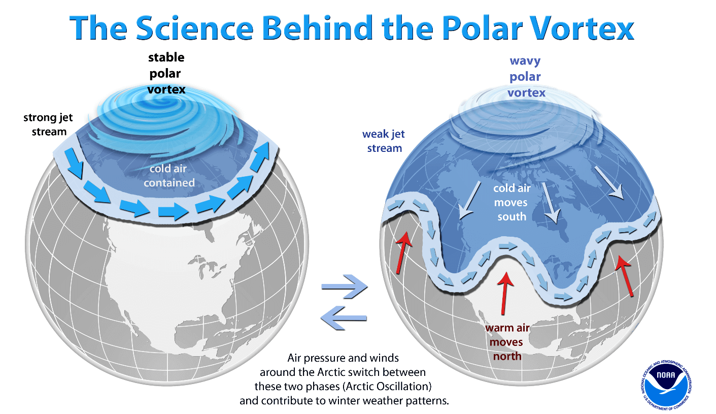
As shown in the image above, we monitor two atmospheric layers during wintertime: the troposphere and the stratosphere. The first is the lowest layer, and the second is at a higher altitude. The Polar Vortex rises through both layers, but with different strengths, shapes, and impacts.
For this reason, we separate the entire Polar Vortex into an upper (stratospheric) and a lower (tropospheric) part. When the Polar Vortex is strong, it traps colder air in the polar regions, preventing its escape and creating milder conditions for most of the United States, Europe, and other mid-latitudes.
But when the Polar Vortex gets disrupted or even entirely collapses, it can’t fully contain the cold air, which can now easily escape from the polar regions into the United States or other mid-latitude regions. Below is an example of how a disrupted Polar Vortex brings cold polar air into the United States and Europe.
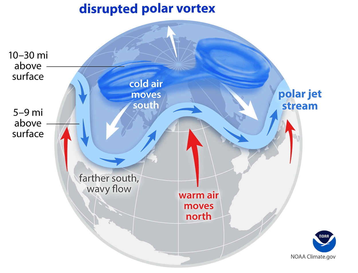
We have experienced this in Asia, Canada, the U.S., and sometimes Europe in recent years. The vortex aloft has been significantly disrupted, and when its lobe shifts on the other side of the northern hemisphere, the extreme cold grips the North American continent.
The disruption of the Polar Vortex and its split at the start of the meteorological Winter season of 2025/26 are the primary triggers of the recent robust cold outbreaks in Siberia, with temperatures around -50 °C.
Soon, the most intense part of the vortex, the southern lobe, shifts to the North American side of the northern hemisphere and spreads across Arctic Canada towards the U.S. From now on, all the fun begins.
Polar Vortex Express weather pattern develops; a Blocking High on the West, troughs on the East, and Canada
What’s typical of the so-called “Polar Express” weather pattern is consecutive Arctic cold waves moving from northwest to southeast across North America along the corridor between the Omega blocking High on the West and over Greenland. So, there is an open channel for the icy Arctic air mass to spread across Canada and the U.S.
This weather pattern typically forms when the Polar Vortex splits and a considerable blocking High establishes over Eastern Siberia and Alaska, where the frigid cold first sets in. Once the corridor opens, the Arctic cold pool has a clear path to spread far south across the continent.
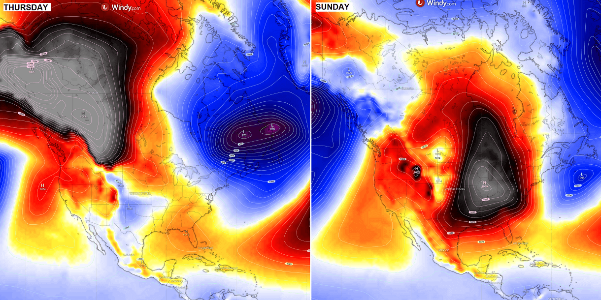
Though midweek, an enormous surface high-pressure system establishes over Alaska and the Yukon, Canada, while a deep, large surface low is parked across the Northeast U.S. and Eastern Canada. In between, Arctic air mass outbreaks are sent southward, with nothing to stop them from maintaining the cold pool and expanding it.
Then, over the following weekend, the high-pressure system gradually expands across the U.S., sending the cold further south and east, gripping tens of millions with extreme cold.
As a result of robust large-scale features, with High on the West and Low on the East, powerful jet stream winds develop across the continent. This is well-aligned with the tracks of the Polar Express storms from Western Canada towards the Upper Midwest and Eastern U.S.
With the pattern completely under the effects of the Polar Vortex split aloft, no significant changes are foreseen throughout mid-December and possibly even further. The blocking High remains locked in over the West, while a deep trough continues to penetrate far south over Canada and the U.S.
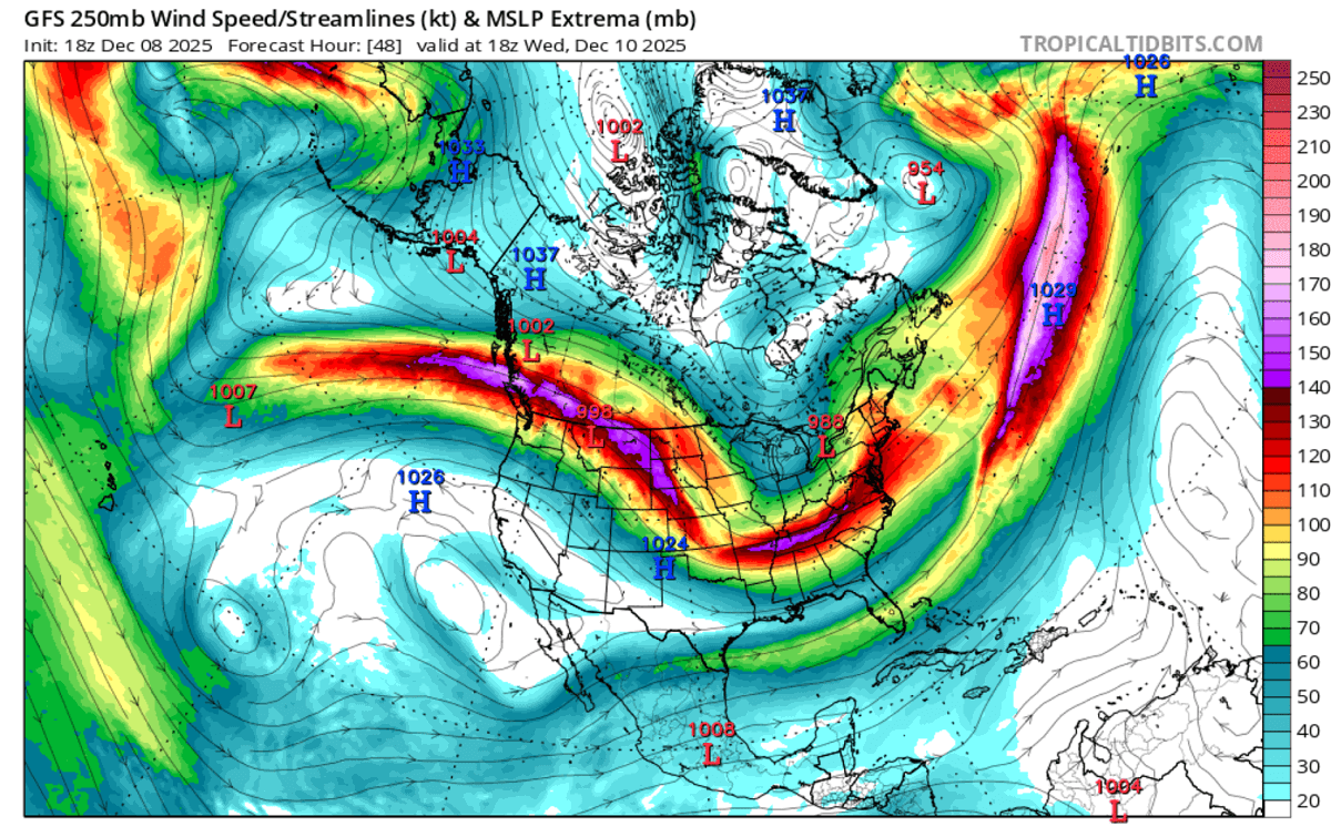
From late Tuesday through Thursday morning, a fast-moving winter storm moves from Alberta across the Upper Midwest to the Northeast U.S., with short but heavy snowfall along its path. Cold weather follows behind it soon after.
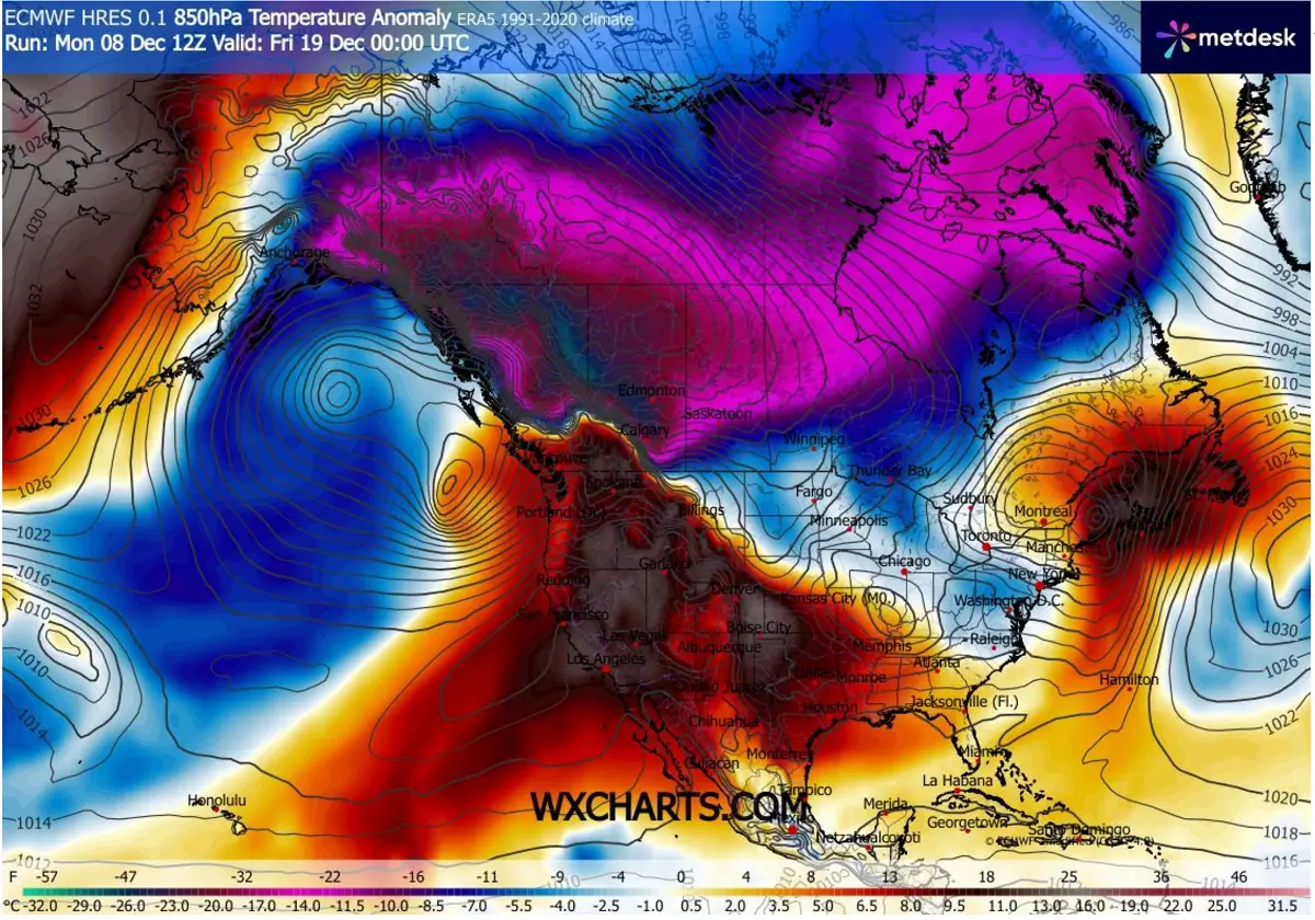
The coldest air mass of the season arrives in southern Canada on Thursday and Friday, with 850-mb temperatures around 16-20 °C below normal over Alberta and Saskatchewan. It progresses towards the south quite aggressively and fast on Friday, thanks to powerful winds aloft.
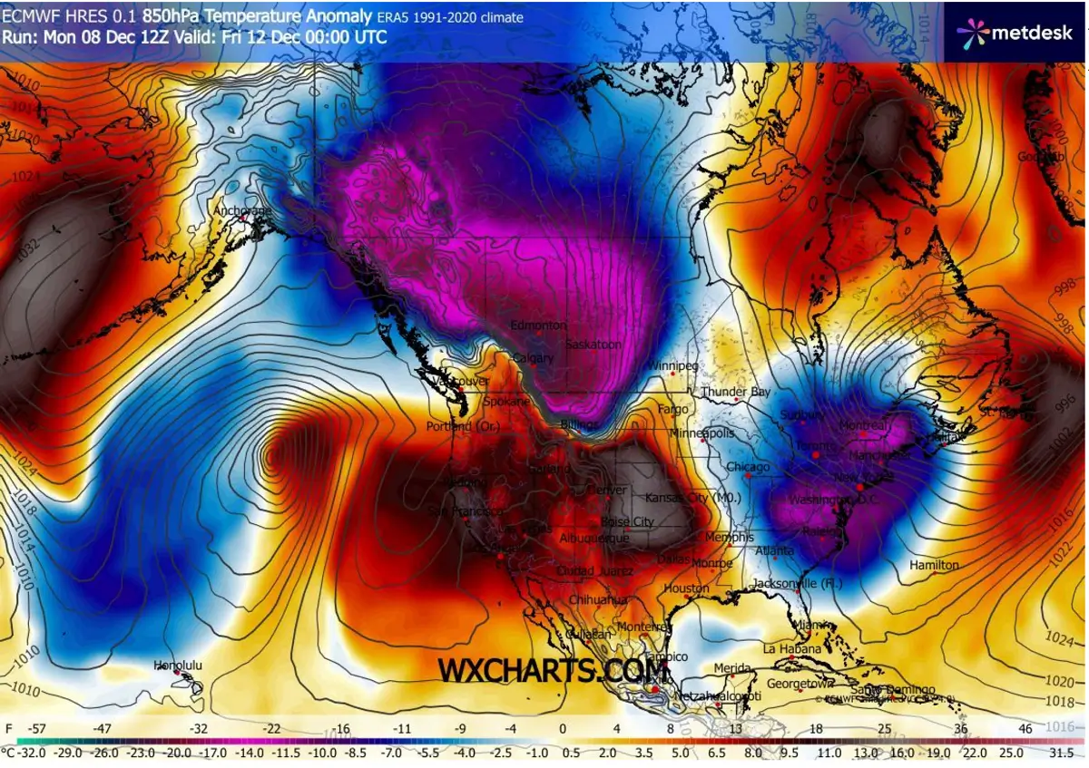
Over the weekend, the blocking High on the West strengthens further and helps the Arctic cold pool intensify, reaching the Mid-Atlantic and Northeast U.S. by Sunday. With a frigid air mass bringing mid-level temperatures around 15-20 degrees below normal.
While the huge dome underneath the Omega blocking High on the West temporarily warms up the air mass across the Rockies and the Great Plains.
It remains brutally cold over Alaska and northwestern Canada, with no significant changes foreseen. Most likely extending the frigid, extreme cold until the Christmas holidays.
A frigid cold air mass starts to spread over Canada towards the eastern two-thirds of the U.S. throughout this week
With nothing to stop the Polar Express dynamics, the extreme cold will first establish over Canada, and then gradually but rapidly spread south into the Central and Eastern U.S. late this week into the following weekend. The enormous cold pool follows the established surface high-pressure system behind the fast-moving snowstorm during mid-week.
The frigid cold spreads across Alberta and Saskatchewan, Canada, on Thursday, and reaches the northern U.S. states by Friday morning. The cold then continues into the Midwest and the Great Lakes on Friday and Saturday, reaching the Mid-Atlantic and the Northeast U.S. on Sunday.
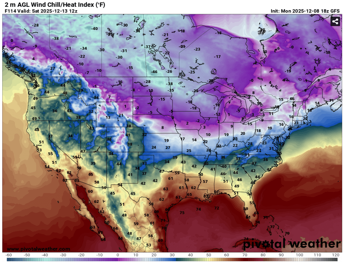
With substantial pressure differences between the west and east, surface winds will remain strong. Therefore, contributing to extremely low wind chill temperatures, locally reaching close to -50 °F, on Saturday morning across southern Canada, towards North Dakota and Minnesota.
Low wind chills will persist over the weekend into early next week as the cold pool spreads into the Eastern U.S.
There will be quite some snow over the following 10 days, thanks to multiple fast-moving winter storms from Western Canada across the Great Lakes to the Northeast U.S. In general, around 5-10 inches of snow will accumulate for many, with more snow around the lakes.
There, the extreme cold under typical northwesterly flow will contribute to intense and persistent lake-effect snowfall, increasing local snow accumulations downwind of Lakes Michigan, Erie, and Ontario.
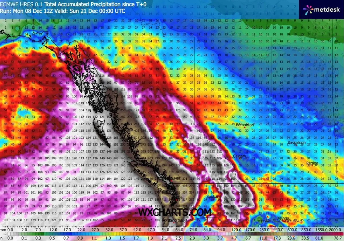
Notice an extreme snow pack expected across western British Columbia – see further details below.
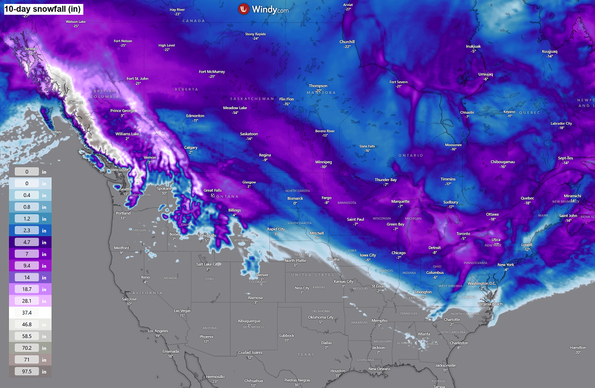
To the north of the blocking High on the Western CONUS, a persistent and intense atmospheric river will dump a tremendous amount of rain and snow across the Pacific Northwest region. Rainfall sums will be up to 400mm (15 inches) or even more locally. Major flooding will become an issue for western Washington and Oregon and will worsen over time.
The fresh snow will reach 200-300 cm (7-10 feet) accumulated over the next 10 days across the interior mountain range, as seen in the image above.
Given the lack of significant changes in the over pattern across Canada and the U.S., the Polar Vortex’s southern lobe will continue to push frigid, icy air south across the continent.
The general trends for the next week hint at another enormous cold pool over Alaska and northwestern Canada developing, then emerging across Central Canada into the U.S, potentially reaching the deep South as well. But more updates on this will follow once we come closer to these events.
We continue to closely monitor the evolution of the progressive patterns across North America in the coming weeks. Following the unusually early and significant disruption of the Polar Vortex and its split this winter, conditions are prone to rapid changes. And also make the Christmas snow forecast challenging – see below.
Stay tuned for further updates.
Windy, TropicalTidbits, and Wxcharts provided images used in this article.