An active weather pattern over the United States continues. A deep lobe of the Polar Vortex plunges south from Canada into the heart of the country over the weekend, triggering a new powerful late-season Winter Storm Iona.
The significant displacement of Arctic air mass brings another major surge of frigid air deep into the central and eastern United States, setting the stage for an explosive winter storm and a snow blizzard on Sunday.
A clash between a dense Arctic air mass and warm, moisture-rich air sharpens a temperature contrast across the nations, making the ideal environment for rapid cyclogenesis on Sunday.
The weather forecast models indicate that the developing surface low will undergo bombogenesis, a rapid intensification. It will become a bomb cyclone, a storm that is defined by a central pressure drop of more than 24 millibars within 24 hours.
The winter storm Iona will begin organizing across the Midwest early Sunday, then rapidly intensifying as it tracks toward the Great Lakes and the Northeast Sunday night into Monday. With the bomb cyclone deepening fast, a powerful pressure gradient will develop around the storm, generating damaging winds and widespread blowing snow and blizzards.
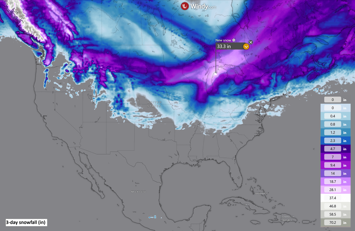
The worst impacts will be across the Upper Midwest and northern Great Lakes, where snowfall totals could exceed two feet (25-30 inches) while wind gusts reach 60-70 mph. Such conditions will quickly develop extreme blowing snow, blizzard, and whiteout travel conditions, drifting snow, and major power outages.
The system matures Sunday night, and heavy snow and blizzard conditions are expected to expand toward the interior Northeast.
Behind the cyclone, a renewed major surge of Arctic air will spread southward from Canada into the eastern two-thirds of the United States, sending temperatures into a deep freeze. It will also trigger an intense lake-effect snowfall over the Great Lakes on Monday through Wednesday.
Key Highlights for the Winter Storm Iona:
Explosive Bombogenesis: A powerful late-season winter storm will undergo rapid cyclogenesis, becoming a bomb cyclone over the Midwest and Great Lakes on Sunday. The system is driven by a deep south plunge of the Polar Vortex.
Blizzard Conditions: Heavy snowfall combined with severe winds will produce widespread blowing snow, blizzards, and whiteout conditions across parts of the Midwest and Great Lakes Sunday through Monday.
Extreme Cold & Flash Freeze returns: Behind the storm, a major surge of Arctic air will bring a sharp temperature drop and deep freeze conditions, dramatically ending the brief spring-like warmth that recently developed.
Extended Impacts: High-impact weather will shift towards the Northeast U.S. by Monday, with significant lake-effect snow developing with the powerful Arctic cold winds behind the center low over the Great Lakes.
This weather configuration represents a classic late-season bomb cyclone scenario, driven by the interaction between a displaced Polar Vortex lobe, a powerful jet stream, and abundant Gulf moisture surging north.
Following a major Stratospheric Warming, the final disruption and the collapse of the polar vortex occur. Sending its southern lobe deep south from Canada into the United States. Releasing a major cold wave of Arctic air intrusion behind the bomb cyclone storm, Iona’s primary circulation. A full-scale displacement of Arctic air into the East and Southeast U.S. brings a prolonged hard freeze.
Before we dig into the details of the impactful new Winter Storm Iona, it is essential to understand the background mechanisms governing the Polar Vortex.
Note that this is the primary driver of rapid weather changes and intense Arctic outbreaks across Canada and the United States during winter, bringing extreme cold deep into the South, toward the Gulf Coast.
What is the Polar Vortex?
The Earth’s atmosphere has six layers. Most of the dynamics of our daily weather occur in the lowest two layers of the atmosphere, the troposphere and the stratosphere.
The troposphere is the layer closest to the Earth’s surface. It is about 12 km deep and extends from the ground up high into the sky. Depending on where you live, its depth varies from around 8 km to almost 20 km. The troposphere is deepest over the equatorial region and becomes much thinner over the North and South poles.
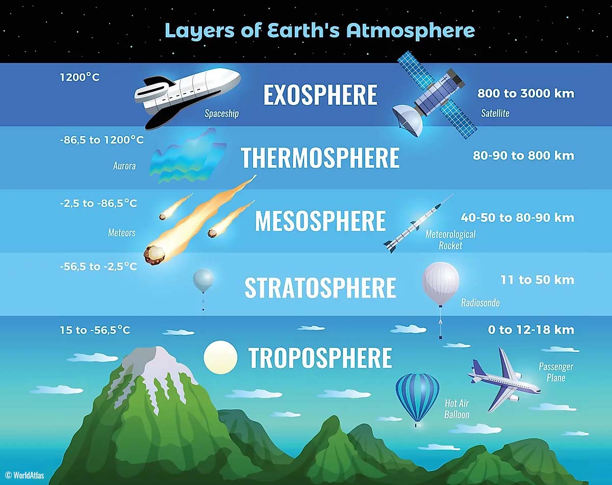
Above this layer is a much deeper one known as the Stratosphere, an 11-50 km thick layer of arid air. Another essential feature in the stratosphere, which makes our weather even more variable, often triggers significant, large-scale, long-lasting winter weather events.
This is the Polar Vortex—an enormous, tri-dimensional ring of powerful winds moving through the sky above us. The Polar Vortex is spinning around the North Pole, grazing through the air at about 20-50 km above the Earth’s surface with violent wind speeds.
How and when does the Polar Vortex form?
Due to the Earth’s inclination, the polar regions receive much less energy from the Sun during the fall months. This makes the cooling over the northern areas more robust. As a result, polar nights can last several consecutive months, followed by days without sunlight.
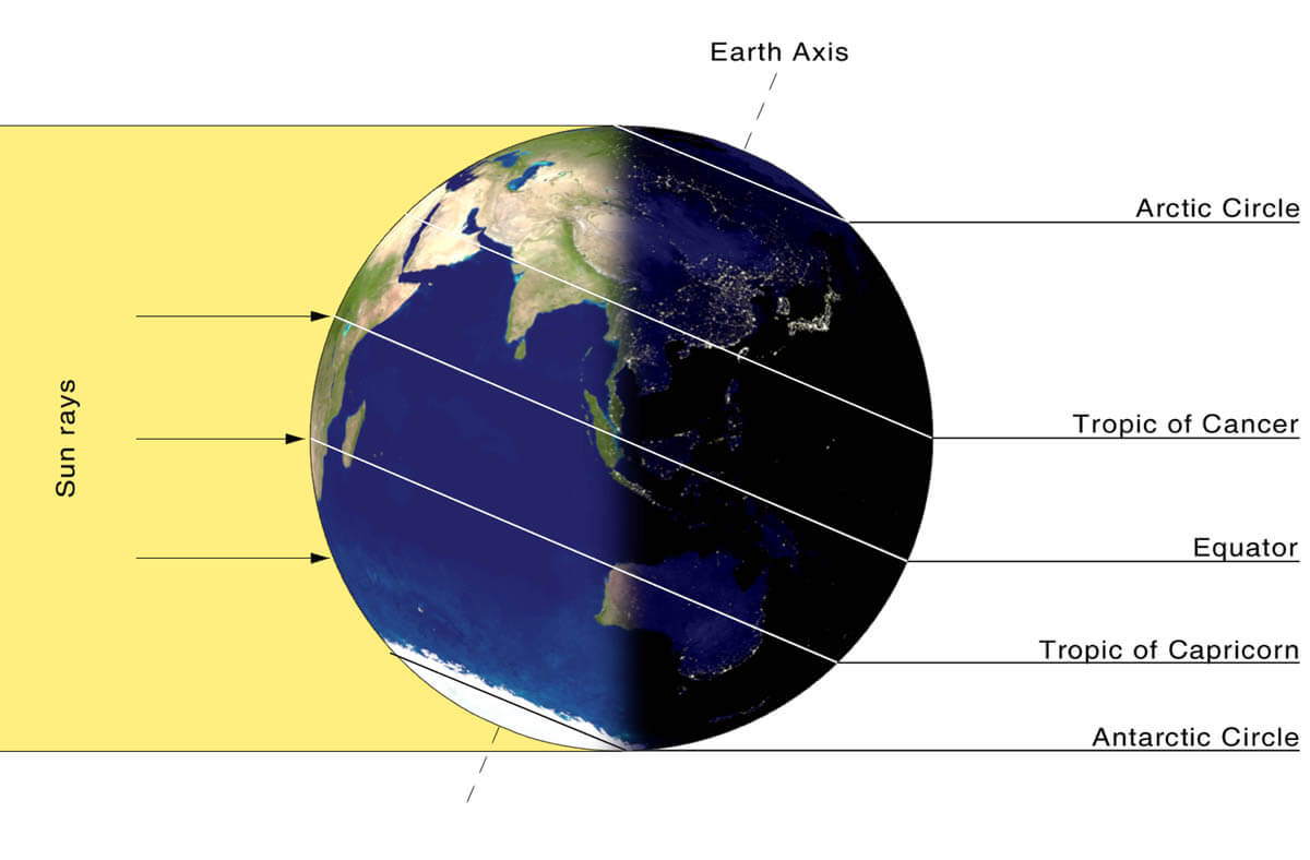
While temperatures in the polar regions are dropping into a deep freeze, the atmospheric layers farther to the south are still relatively warm because they receive more of the Sun’s energy at the same time. Therefore, the south’s equatorial layers remain much warmer than the areas farther north, leading to a high-temperature contrast.
Cooling the polar regions also lowers the ambient surface pressure, and a similar weather process occurs in the stratosphere. The temperature difference between the North Pole and the equatorial areas increases across both layers.
This creates a large, low-pressure cyclonic circulation across the polar stratosphere, which gives it its famous name—the Polar Vortex.
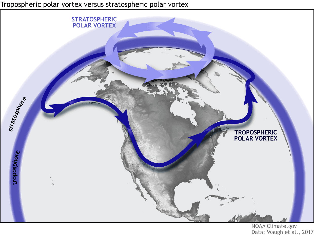
As shown in the image above, we monitor two atmospheric layers during wintertime: the troposphere and the stratosphere. The first is the lowest layer, and the second is at a higher altitude. The Polar Vortex rises through both layers, but with different strengths, shapes, and impacts.
For this reason, we separate the entire Polar Vortex into an upper (stratospheric) and a lower (tropospheric) part. When the Polar Vortex is strong, it traps colder air in the polar regions, preventing its escape and creating milder conditions for most of the United States, Europe, and other mid-latitudes.
But when the Polar Vortex gets disrupted or even entirely collapses, it can’t fully contain the cold air, which can now easily escape from the polar regions into the United States or other mid-latitude regions. Below is an example of how a disrupted Polar Vortex brings cold polar air into the United States and Europe.
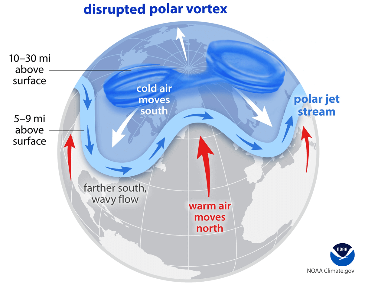
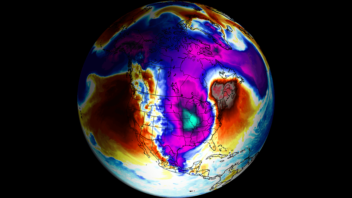
We have experienced this in Asia, Canada, the U.S., and sometimes Europe in recent years. The vortex aloft has been significantly disrupted this season, and when its lobe shifts away from the North Pole, the extreme cold grips the North American continent.
A deep core of the southern Polar Vortex lobe digs into the United States on Monday
The large-scale weather pattern across North America is becoming increasingly dynamic, with a textbook dipole pattern of a large blocking High over the North Pacific and Western CONUS. While a deep trough associated with a Polar Vortex lobe digs southward from central Canada into the Eastern United States.
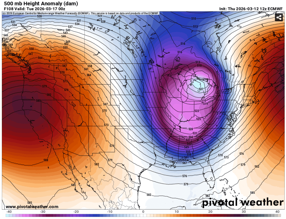
At upper levels, a powerful jet stream wind exceeding 130 knots is forecast to round the base of the deep Polar trough, providing strong divergence aloft. The deep trough dramatically amplifies the jet stream and provides the cold-air reservoir needed for explosive surface-storm development.
This creates ideal environmental conditions for rapid surface cyclogenesis on Sunday.
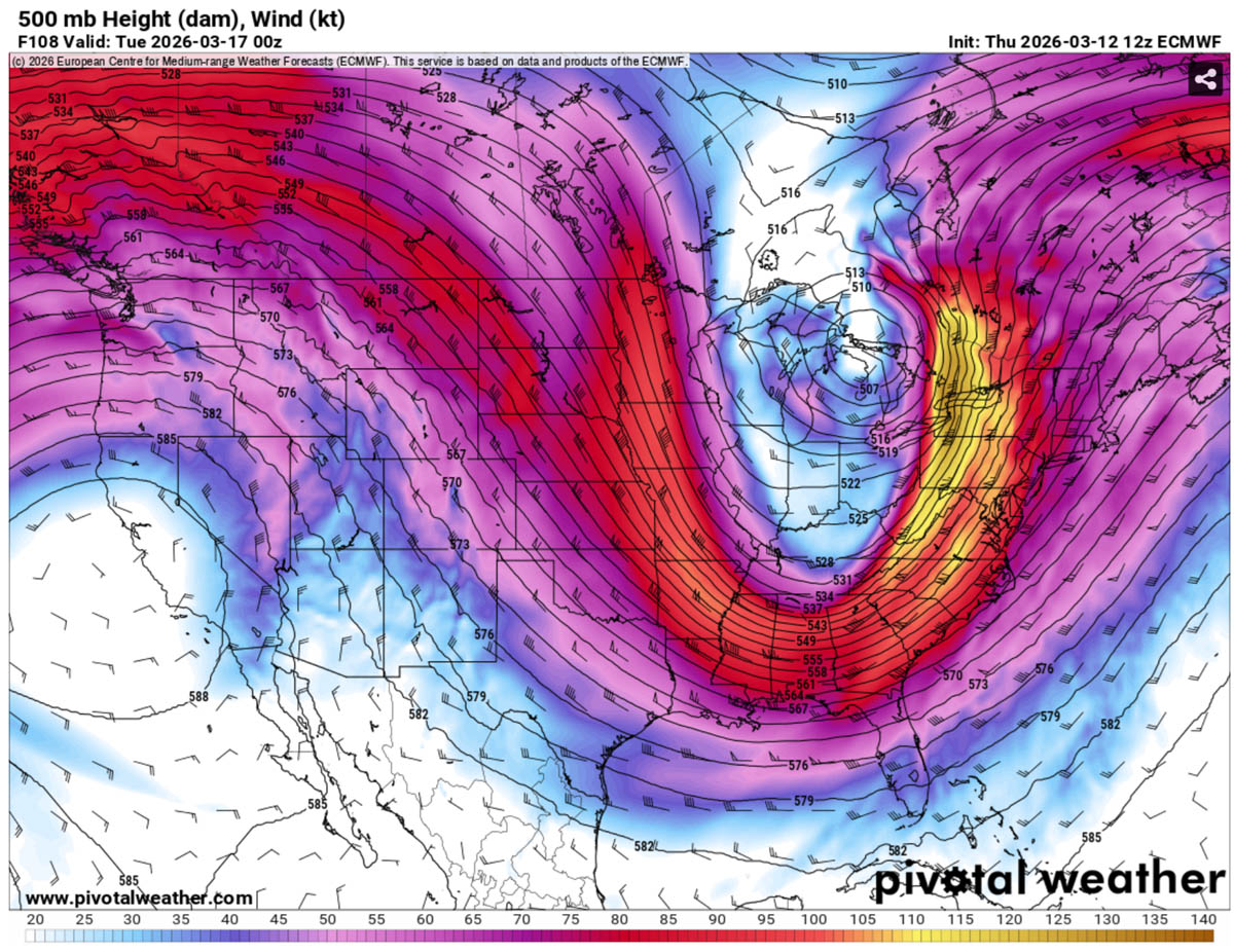
The weather forecast models hint at a developing surface low across the central Plains and Midwest early Sunday, which deepens rapidly as it moves toward the Great Lakes region Sunday night through early Monday. Explosive cyclone development occurs, acting as a bombogenesis with pressure falls of more than 24 millibars in 24 hours, meeting the official criteria for a bomb cyclone.
At the same time, a robust southerly flow from the Gulf of Mexico is transporting warm, humid air northward ahead of the system. The collision between this moisture-rich air and the advancing Arctic air mass creates a powerful temperature gradient, providing the energy needed for explosive cyclogenesis as time unfolds.
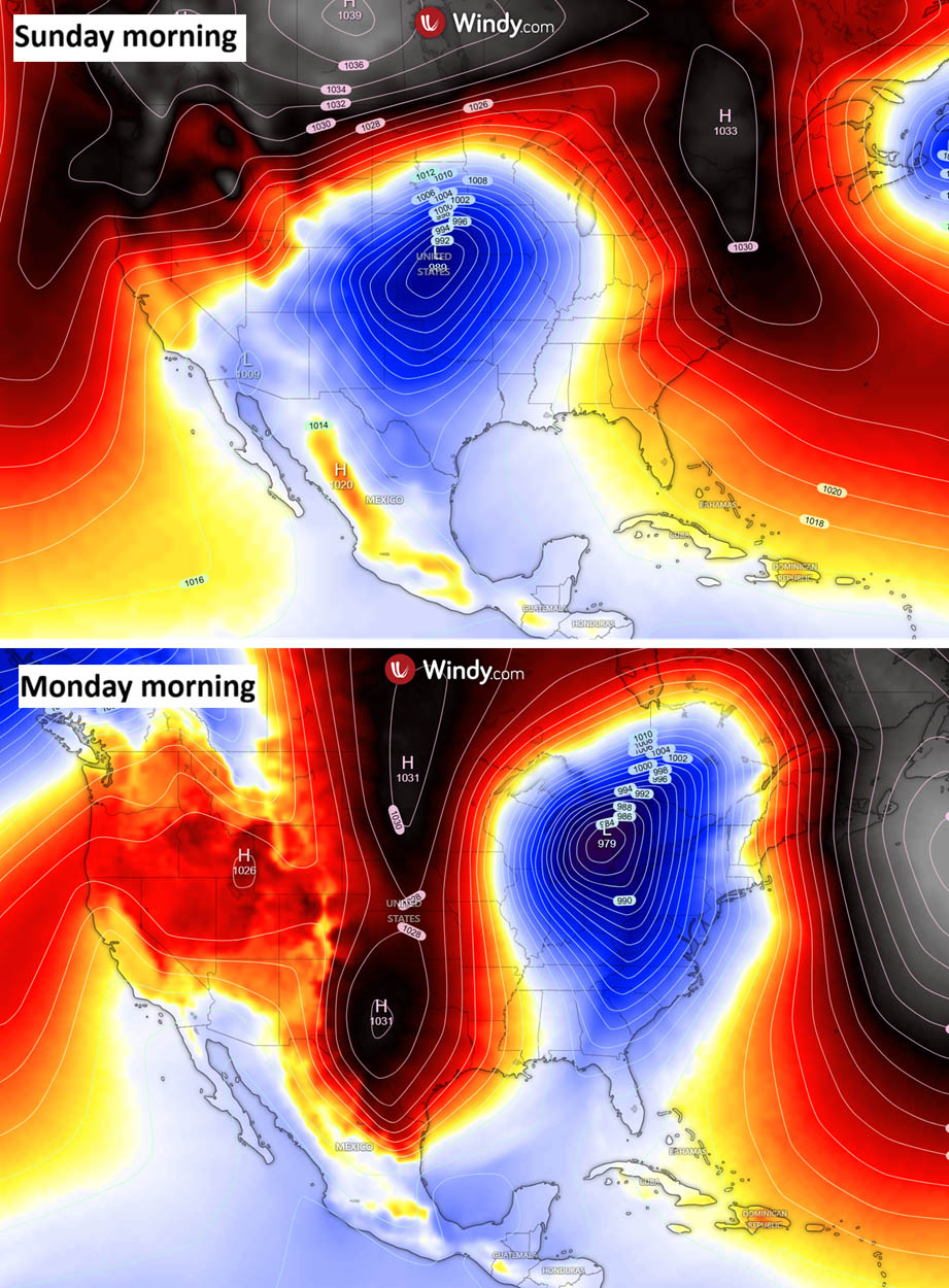
As the low intensifies, the pressure gradient surrounding the system will tighten significantly, producing powerful winds and widespread blowing snow across the storm’s northern sector. With heavy snowfall, this setup can produce full-blizzard conditions with near-zero visibility and severe drifting snow.
What are the Expected Impacts by Region – Deep Snow with Blizzard across Upper Midwest and Great Lakes
Upper Midwest
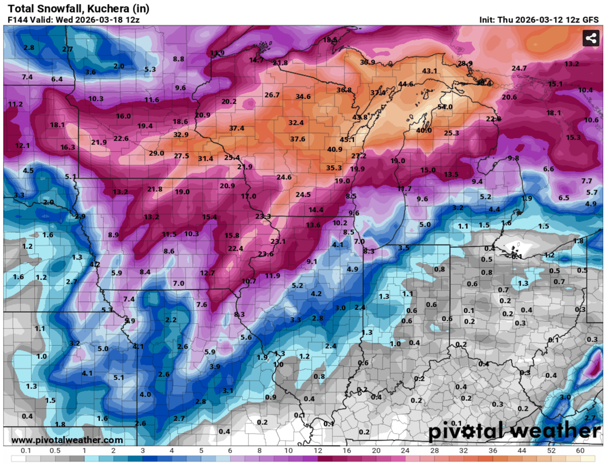
The most severe winter weather is expected across parts of Minnesota, Wisconsin, and Ontario, Canada. Heavy snowfall will combine with powerful winds and produce intense blizzard conditions, with snow totals potentially exceeding 30+ inches in localized areas.
Wind gusts approaching 70 mph could lead to severe drifting snow, extreme whiteout conditions, and dangerous travel conditions, including impassable roads.
Great Lakes Region
As the cyclone tracks toward the Great Lakes on Monday, strong winds and heavy snow will spread across Michigan, northern Illinois, and parts of Indiana and Ohio. Blizzard conditions are likely to develop in some areas, particularly downwind of the lakes, with zero visibility likely.
After the main storm passes, strong west-northwesterly winds will introduce lake-effect snow bands, leading to a prolonged hazardous winter weather across traditional snowbelt regions early next week.
Interior Northeast
By Sunday night into Monday, the storm will begin affecting the interior Northeast, including upstate New York and northern New England. Heavy snowfall and strong winds could cause significant disruptions to ground transportation and air travel, especially in higher terrain and lake-effect corridors.
Central and Southern States
Farther south, the storm will bring a significant temperature plunge as Arctic air surges behind the system from Sunday night through Tuesday. Areas that will experience rain ahead of the Winter Storm could see flash-freeze conditions, as temperatures drop rapidly and wet surfaces freeze within hours after the Arctic front passes.
Deep Arctic cold plunges across the nation behind Storm Iona
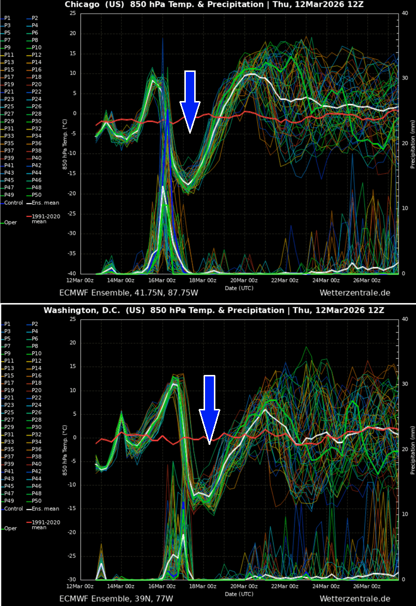
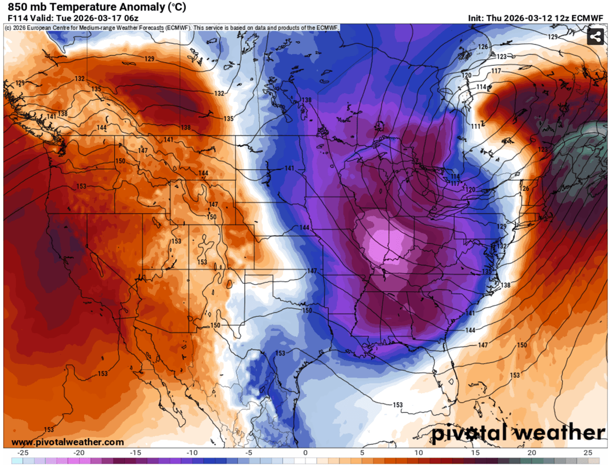
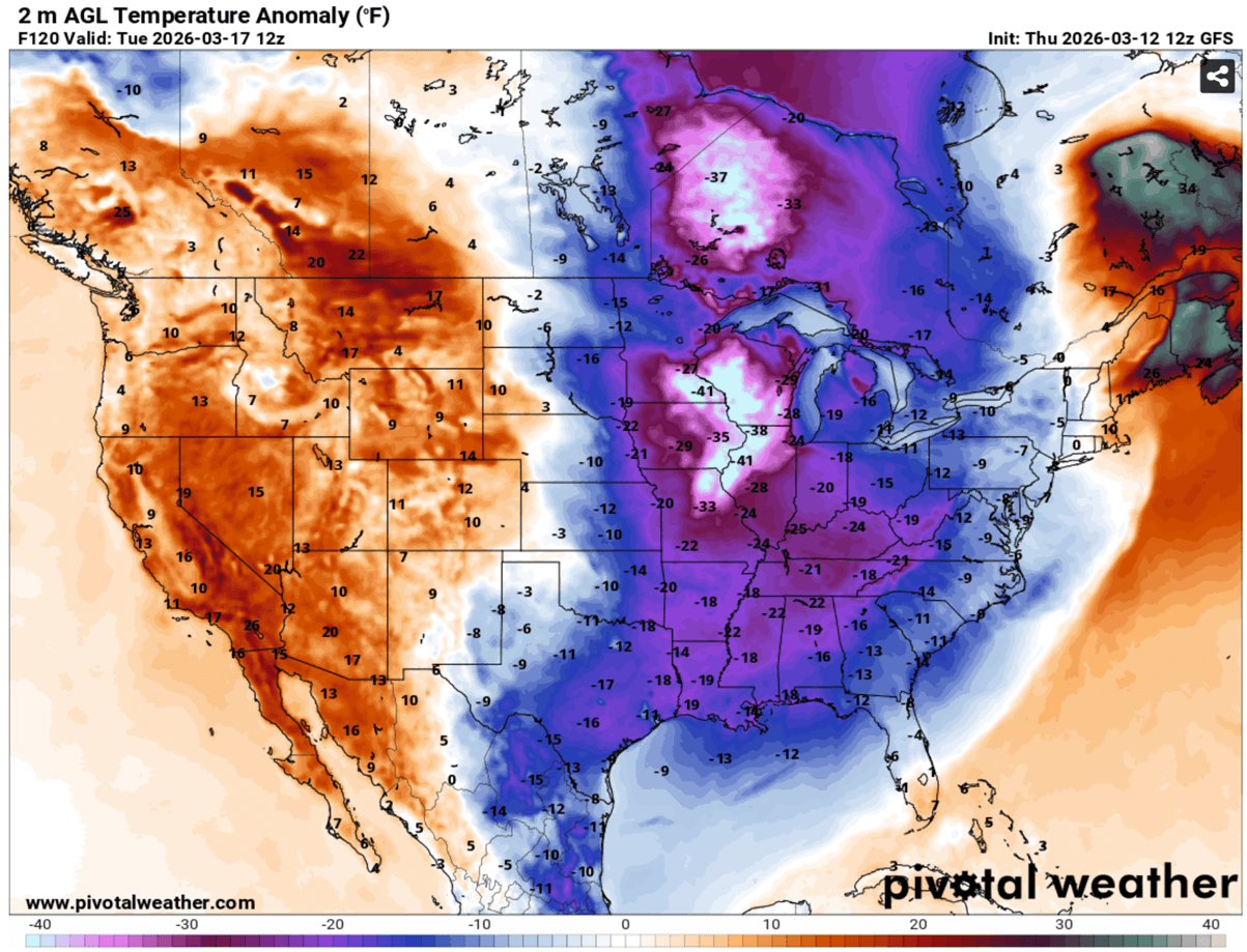
With the rapidly deepening low, the pressure gradient helps drag the Arctic cold air masses far south in its wake, spreading across the eastern two-thirds of the United States from Sunday through Tuesday. Temperatures will be extremely low, with 30-40 °F below normal (20 °C at the 850 mbar level) across the Midwest, the Ohio Valley, and the East Coast.
What is concerning is the strength of the near-surface winds, as a result of the pressure and temperature difference between the center low and the building ridge behind the storm. This should result in particularly severe winds.
Combined with heavy snow, severe blizzard conditions would result in major travel disruptions, whiteout conditions, high snowdrifts, and significant delays. Including flight cancellations.
The final collapse of the Polar Vortex core and its southern lobe, being unusually deep, is the reason it will dig very far south across North America, spreading extreme cold back across the U.S., bringing the wintry cold back towards the deep South, the Southeast U.S., the Mid-Atlantic, and the East Coast.
Monday and Tuesday will bring temperatures into 20-40 °F below normal for more than 100 million people across the nation, with the worst cold across the Upper Midwest on Tuesday.
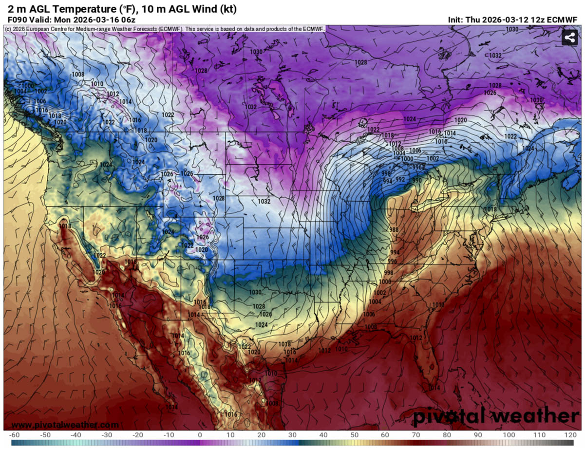
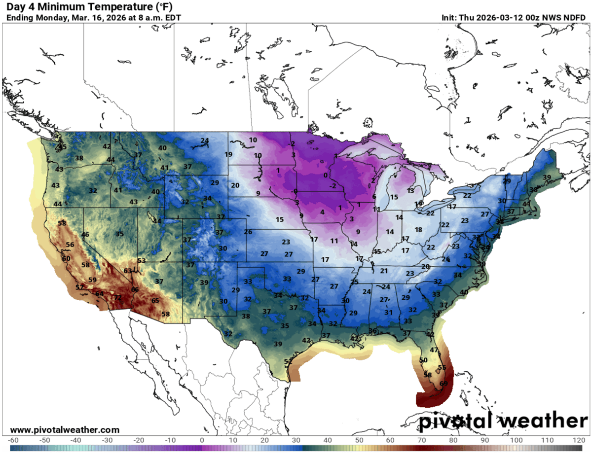
The morning temperatures will be in the single digits across the Upper Midwest, the western Great Lakes, and the eastern Dakotas on Monday. Possibly even in negative degrees F from northern Iowa to Minnesota to Wisconsin. In the tens for the rest of the Midwest and the Ohio Valley, low to mid-20s for the Central Plains and mid-Mississippi Valley to Southeast U.S. on Monday.
Sub-freezing temperatures will reach as far south as central Texas, Louisiana, southern Missisippi, Alabama, and central Georgia on Monday morning.
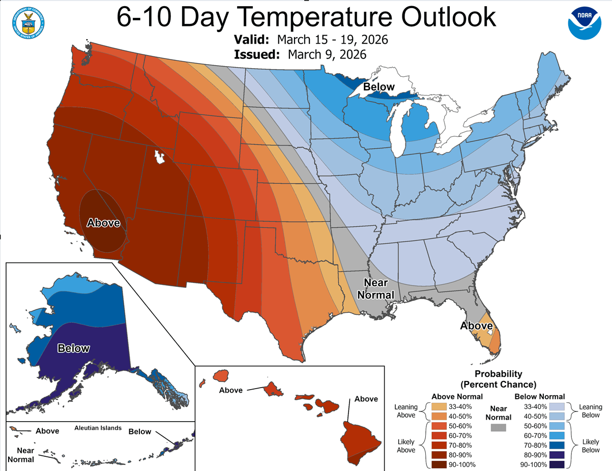
The Spring weather has arrived quickly, and so have the typical severe weather dynamics and rapid changes across the U.S. Soon after warmer temperatures spread across the nation, destructive supercells with record-breaking giant hailstones and tornadoes hit the Midwest in the first severe weather outbreak earlier this week. Now, the pattern flips, and winter will be back.
The mid-term trends suggest that dynamic weather will remain over the CONUS, with alternating cold and warm periods as the Polar Vortex collapses. We will continue to monitor and update the outlooks as the pattern evolves. Stay tuned for further updates.
Windy, PivotalWeather, and Wxcharts provided images used in this article.