We are currently observing an unusual Polar Vortex development in the Stratosphere above the North Pole. This has implications and future weather development and is also connected to how weather patterns will develop over the United States, Canada, and Europe in the coming weeks and even into the Winter of 2025/2026.
We discussed the emergence of a new Polar Vortex for September. Since then, the Polar Vortex has shown pretty unusual development, and could be one of the wildcards for the upcoming winter season.
The Polar Vortex always plays a major role during the winter season for daily to weekly weather development. But this year, it is starting out unusually weak, allowing for a more dynamic weather pattern, with implications down the line that look good if you like a colder and snowier winter.
POLAR VORTEX OF THE NORTH
The best way to understand the Polar Vortex is to visualize it. But in simple terms, it is just a name that describes the broad winter circulation over the northern (and southern) hemispheres.
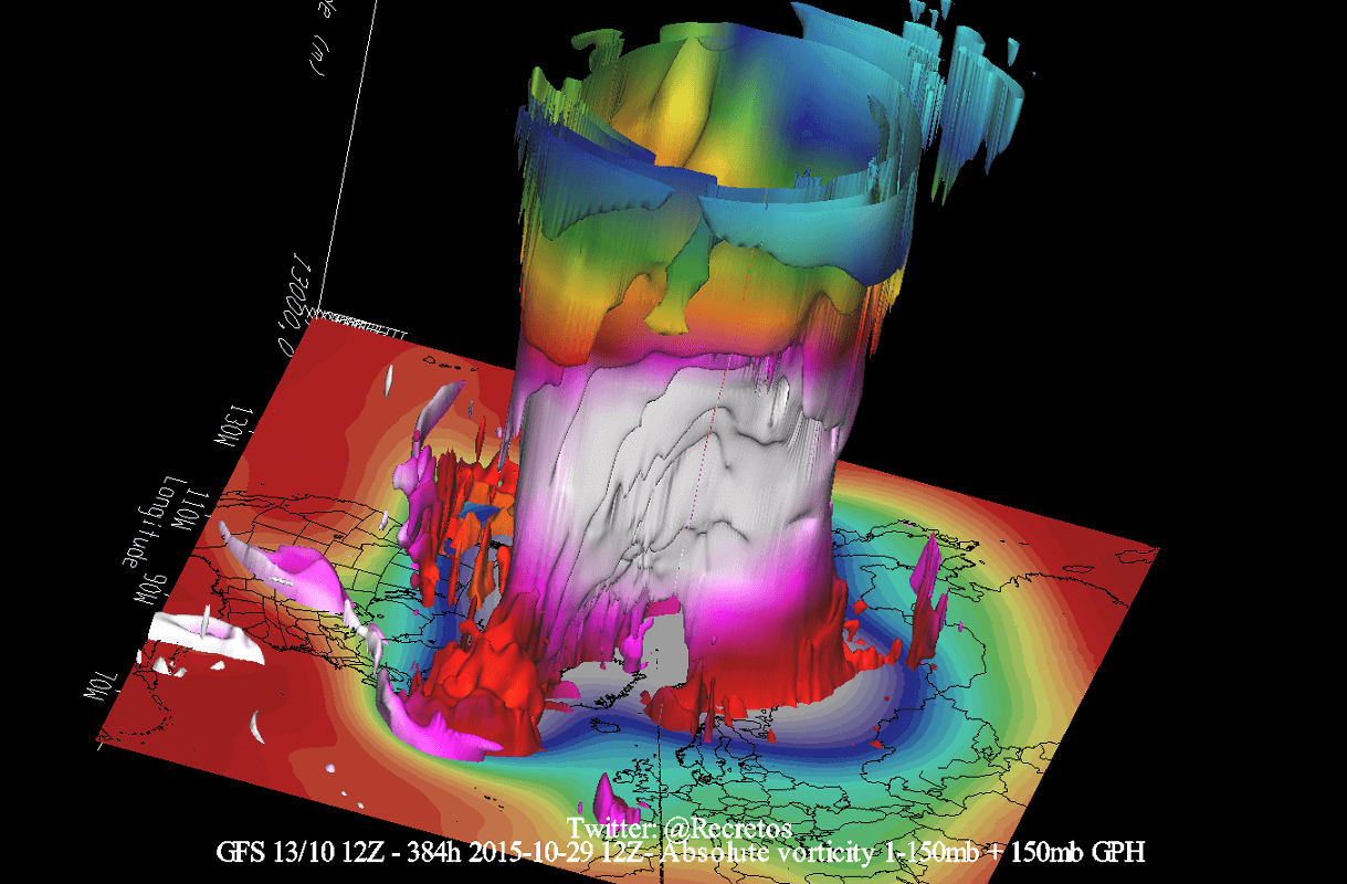
Below, you can see a 3-dimensional example image of the Polar Vortex. The vertical axis is greatly enhanced for better visual presentation. This way, you can nicely see the actual structure of the Polar Vortex and how it is connected down to the lower levels and the pressure systems.
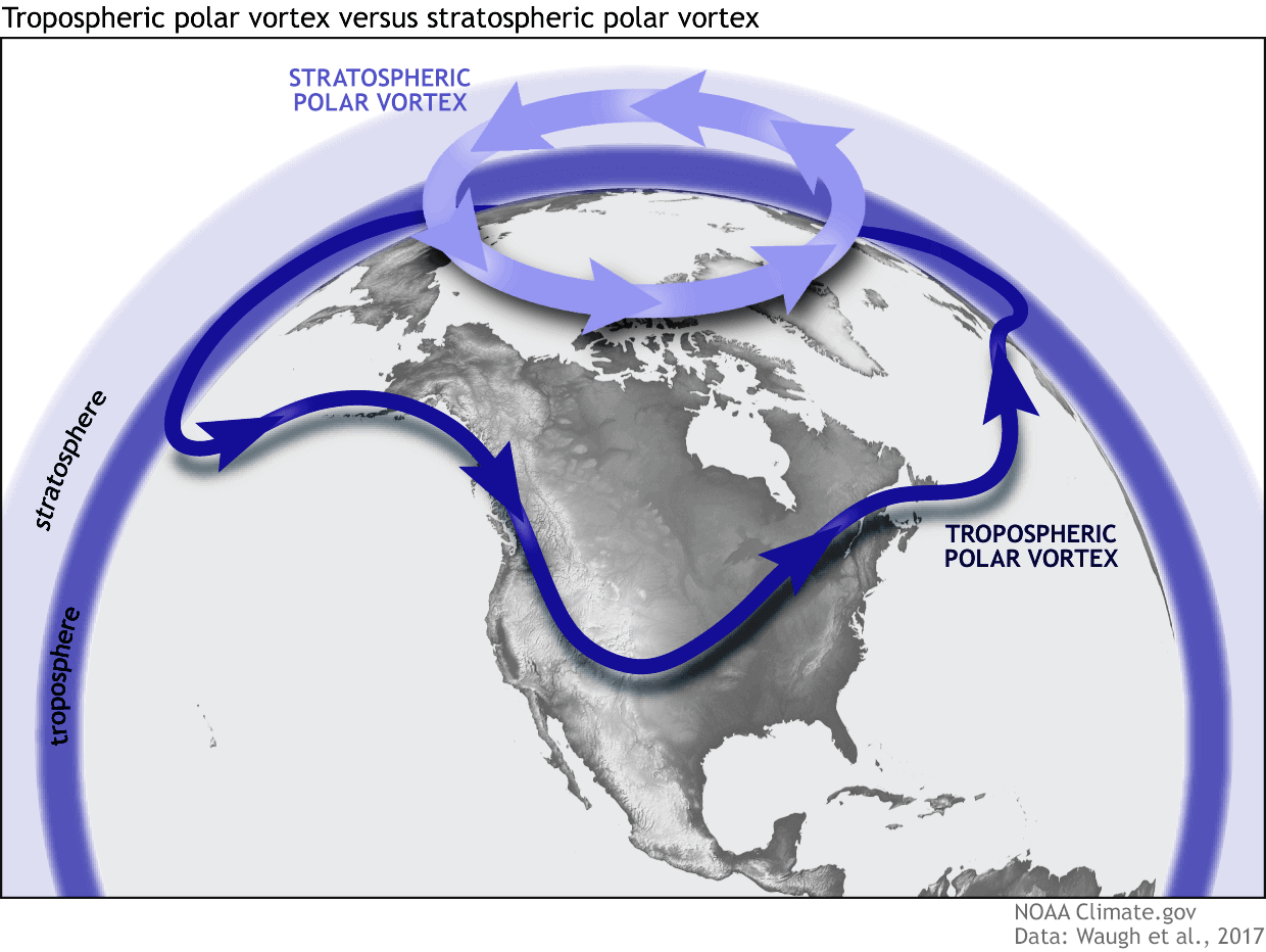
The Polar Vortex extends over many layers of the atmosphere. The lowest layer is called the troposphere, where all weather events occur. But above that, we have the stratosphere, a deeper and drier level that is also home to the ozone layer.
For this reason, we separate the entire Polar Vortex into an upper (stratospheric) and a lower (tropospheric) part. They both play their role differently, so we monitor them separately as they can work independently. But both parts together form the weather circulation across the Northern Hemisphere and shape our daily weather.
To put the Polar Vortex into a full perspective, we produced a high-resolution video below. This video shows the polar vortex in 3D, which gives you a better idea of what it actually looks like. Just note that the vertical size of the vortex was greatly enhanced for visual purposes.
The main takeaway from the video should be that the Polar Vortex is not just one winter storm or a cold outbreak that moves from the Midwest into the eastern United States. It is the entire weather circulation over the Northern Hemisphere.
THE GROWING POLAR VORTEX
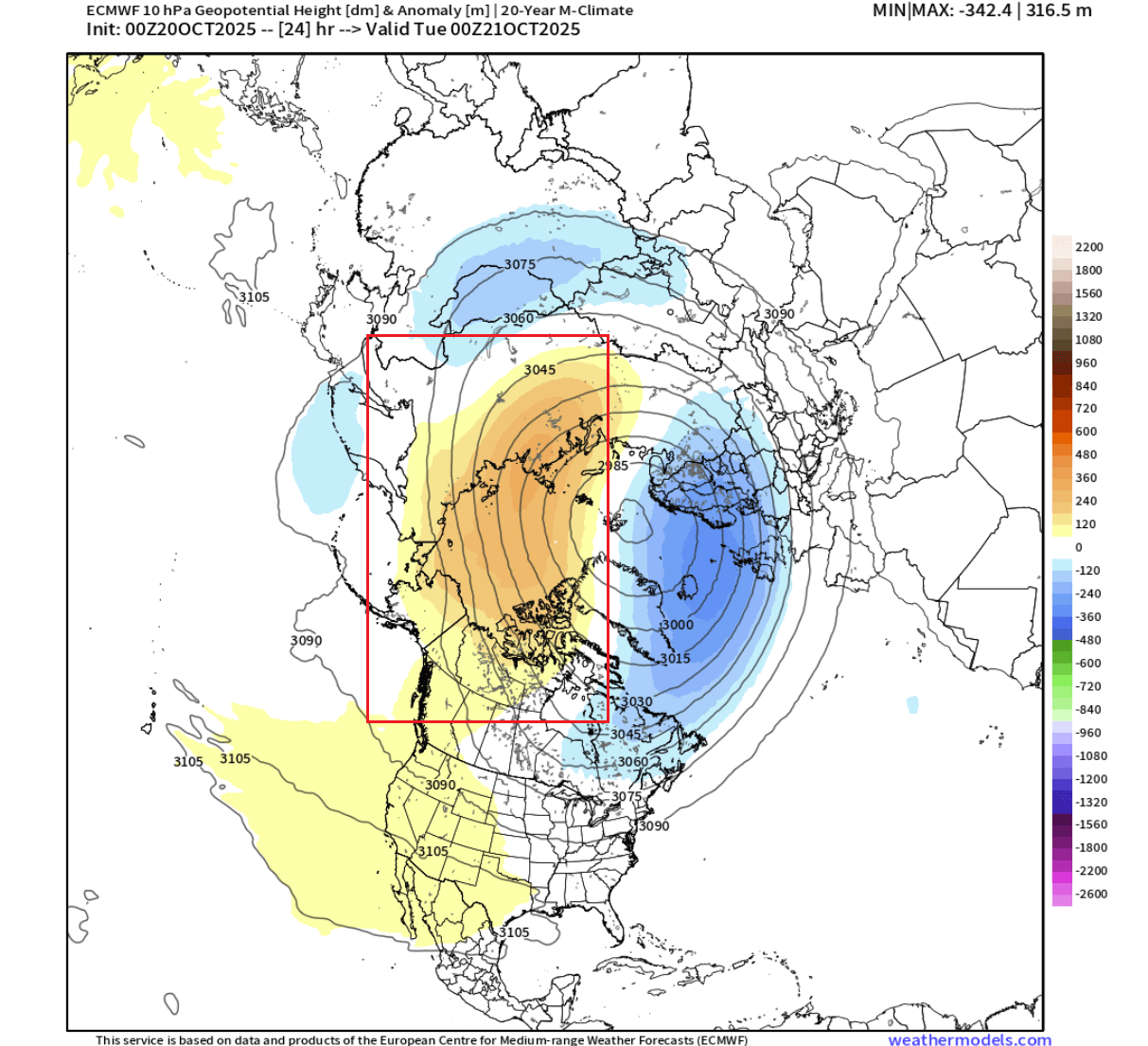
The Polar Vortex is currently still growing in the stratosphere, but it’s already at a good size. The image below shows geopotential height and temperature in the mid-stratosphere at the 10mb level (30km/18.5miles). The Polar Vortex looks like a “cyclone” with a cold core near its low-pressure center. Image by weatheriscool.com
You can see a weaker area on its Pacific side. That is also where an anomaly of high pressure is starting to develop in the Stratosphere, helping to push the Polar Vortex off center and limiting its strengthening.
Below is the image for the same level, but it shows the pressure anomaly. It nicely reveals the pressure anomaly in the stratosphere over the western parts of the Polar Vortex, which aids in displacing it and limiting its overall strength.
Below is the vertical pressure analysis from the ground up to the top of the stratosphere (45km/28 miles). You can see negative pressure anomalies in the stratosphere, connected all the way to the surface levels under an angle to the North Atlantic and towards the Pacific regions.
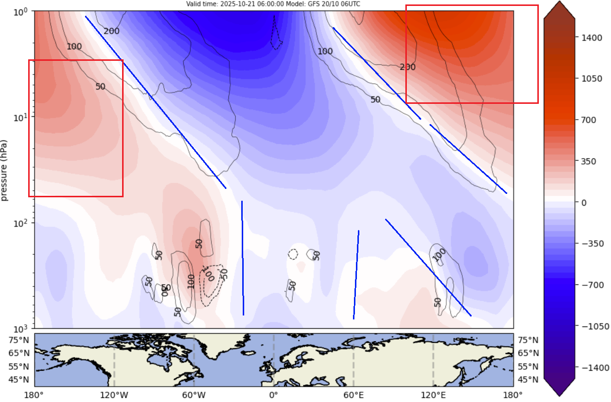
You can also see the high-pressure anomaly surrounding the Polar Vortex over the entire stratospheric level on the Pacific side. This is what is pressing against the Polar Vortex, also affecting its structure and currently limiting its development.
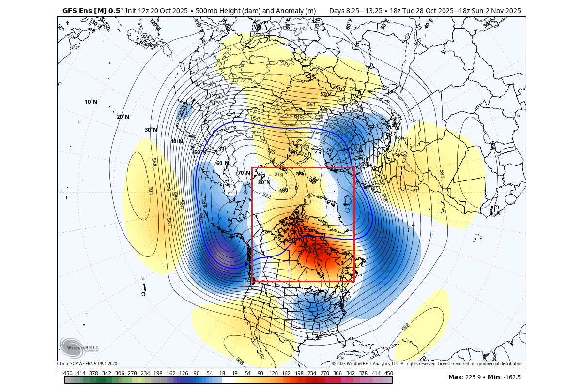
This can be seen reflected in the weather pattern analysis below, which shows the pressure anomalies across the Northern Hemisphere in the next 5 days. A strong high-pressure anomaly is developing over Greenland, pushing into the polar regions. It is strong enough to greatly disrupt the lower Polar Vortex into individual areas.
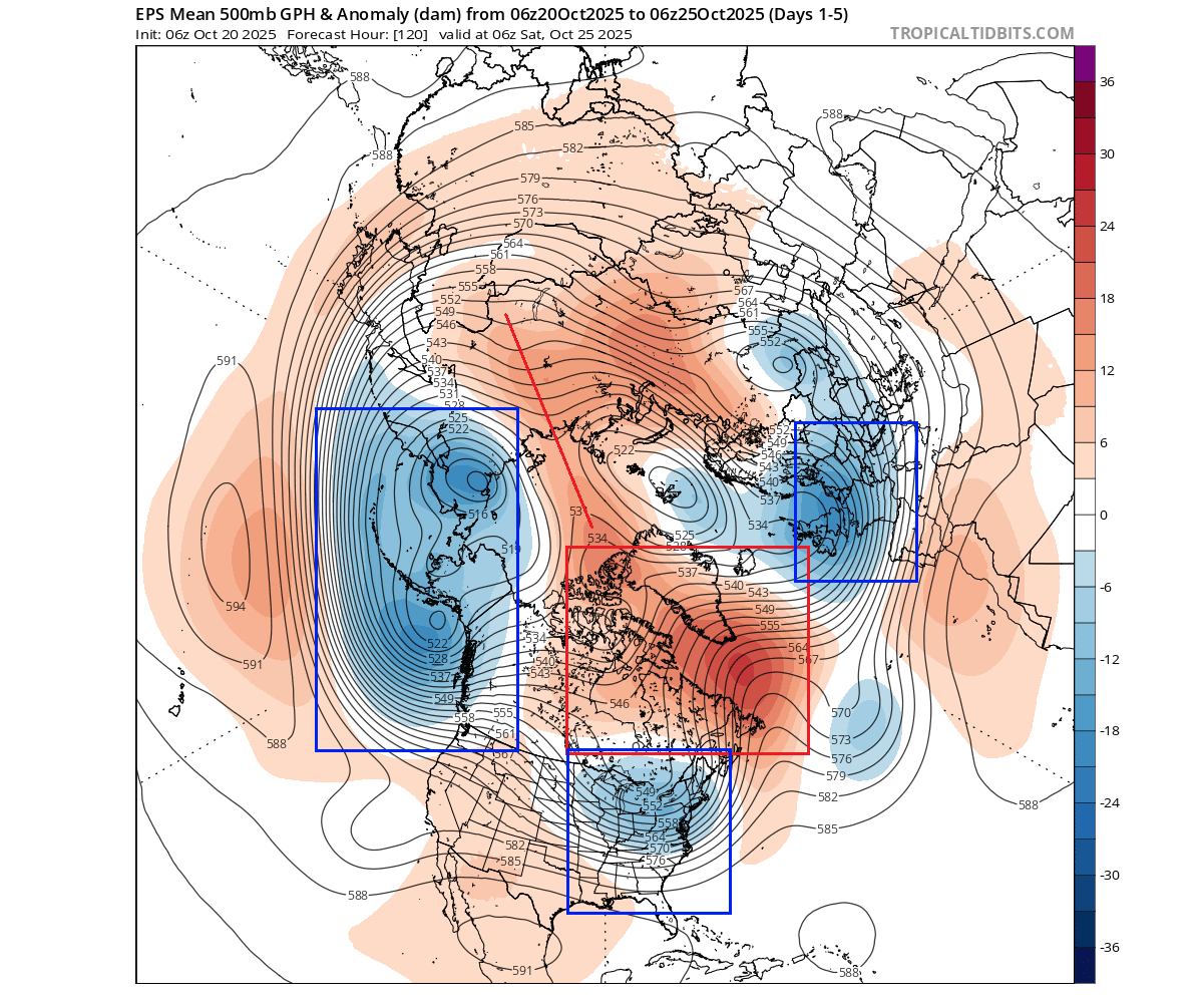
You can see the individual low-pressure areas over the U.S., Pacific, and Europe, which act like the “foot” of the stratospheric Polar Vortex that you could see in the previous image. Such a pattern enables a more unsettled weather period in the eastern United States and parts of Europe.
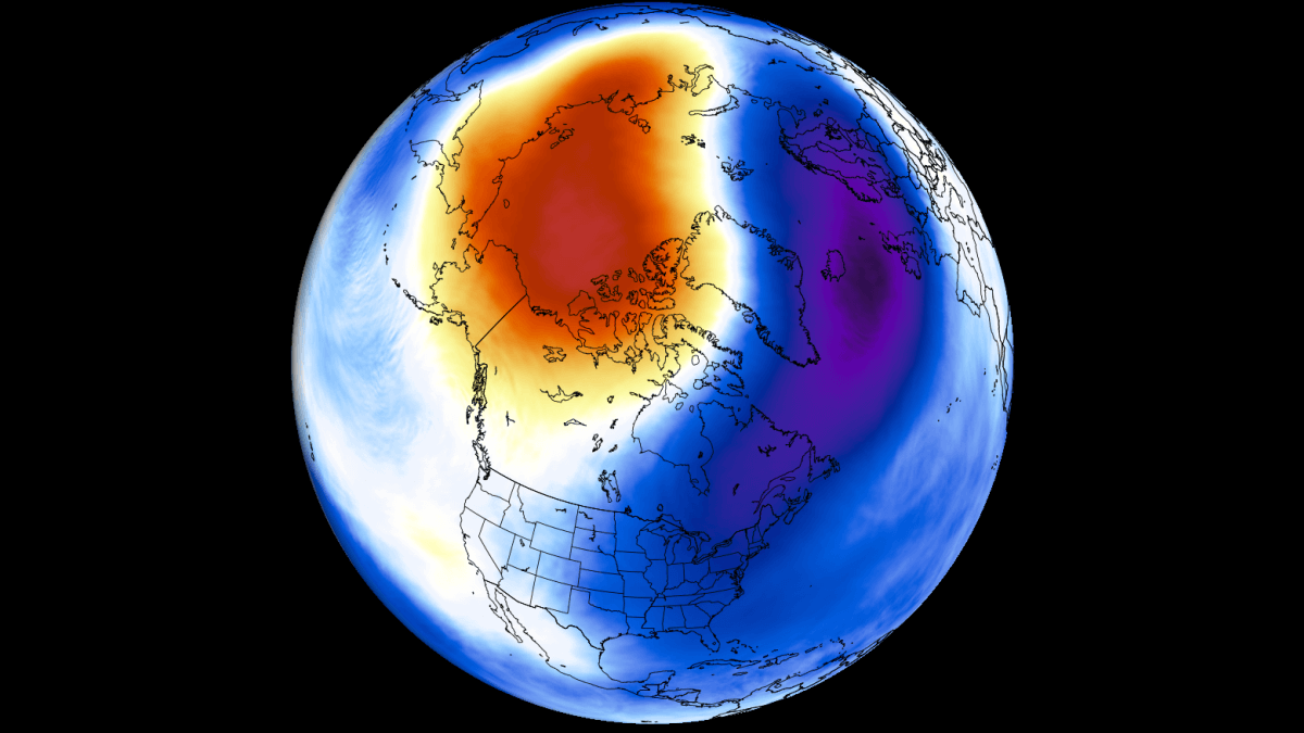
This affects the temperatures over the Northern Hemisphere. With a weaker circulation over the pole, the colder air is transported out. But since we are just in early October, there is not really any strong mass of cold air available for significant low temperatures over the eastern United States, despite a decent-looking anomaly.
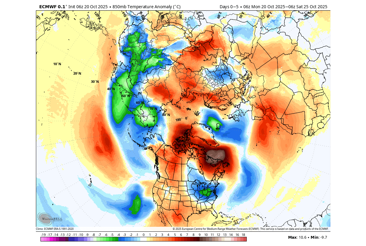
The reason we showed you this is to reveal the connection and importance of the stratospheric Polar Vortex and its link with the weather at the surface. A situation like this in late November or December would have a much different outcome, with more proper winter weather over the central and eastern United States.
For that reason, we must monitor the state of the Polar Vortex, as it can have a profound impact on our daily weather, based on the mode it’s in:
A strong Polar Vortex usually means strong polar circulation and jet stream. This contains the colder air into the Arctic Circle, creating milder conditions for most of the United States and Europe.
A weak Polar Vortex can create a disrupted jet stream pattern and a strong weather response. As a result, it has a harder time containing the cold air, which can now more freely escape from the polar regions into the United States or other mid-latitude regions.
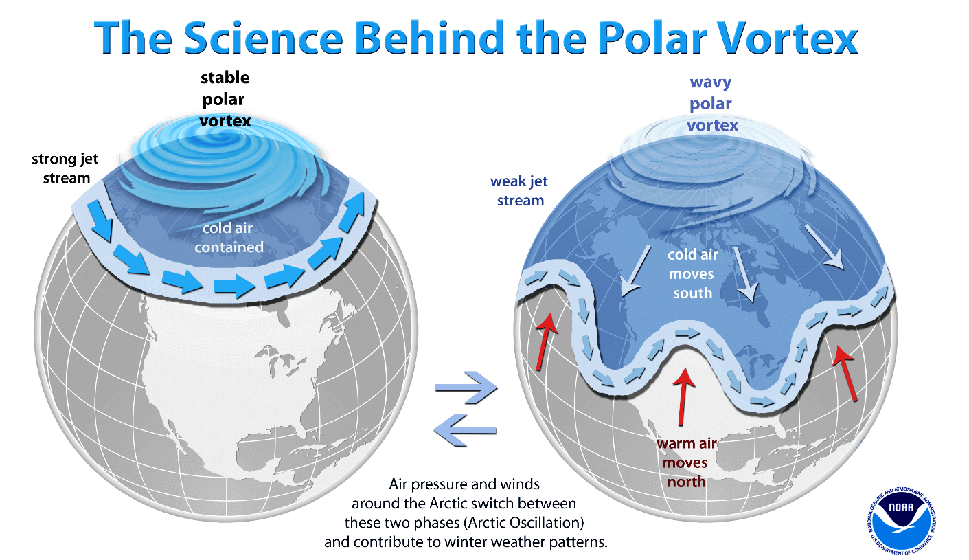
So, if you are a fan of a warmer Winter across the United States or Europe, you will prefer a strong Polar Vortex. But if you like proper Winter weather with cold and snow, a weak/disrupted Polar Vortex is your best bet.
We know that the Polar Vortex is strongest when it’s very cold and has a deep pressure field. And you saw above that there is a pressure anomaly making things difficult for it to organize, keeping it weaker for now.
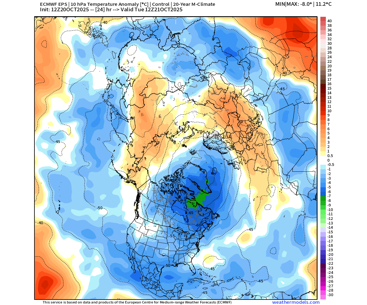
Below is also a temperature anomaly for the mid-stratosphere, where you can see the cold core of the Polar Vortex displaced towards Greenland. Above-normal temperatures are found in the outer shell of the Polar Vortex, helping to keep it tame, at least for now.
For this reason, we closely monitor the strength of the Polar Vortex and all the changes around it. This is even more important when there are sudden changes in the strength of the Polar Vortex, with potential warming events.
ATMOSPHERIC CHANGES BEGIN
How do we measure the strength of the stratospheric Polar Vortex? The simple answer is the wind speed. The more organized the stratospheric Polar Vortex is, the stronger the winds inside and around it, which means it can have a stronger influence on the lower levels.
But of course, even weak stratospheric winds tell us a lot, as they can point to a different type of influence on the lower level.
The image below shows the GEFS wind analysis and forecast for the next 30 days in the mid-stratosphere. Black lines are the ensemble forecasts, and in the background, we have the climatology, showing the normal values and the highest and lowest recorded data.
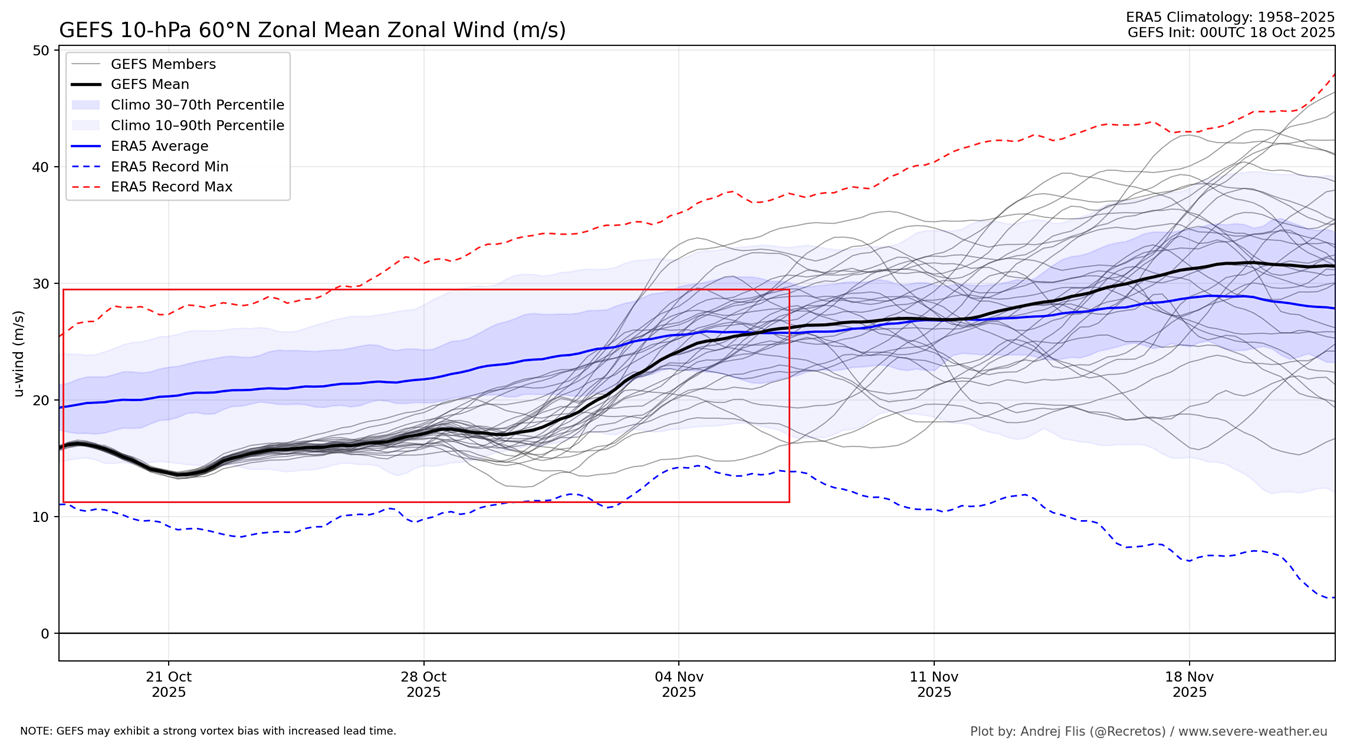
You can see that currently, and for the next two weeks at least, the stratospheric Polar Vortex will be running much weaker than normal. This signals that something is off both in the lower and especially in the higher parts of the atmosphere.
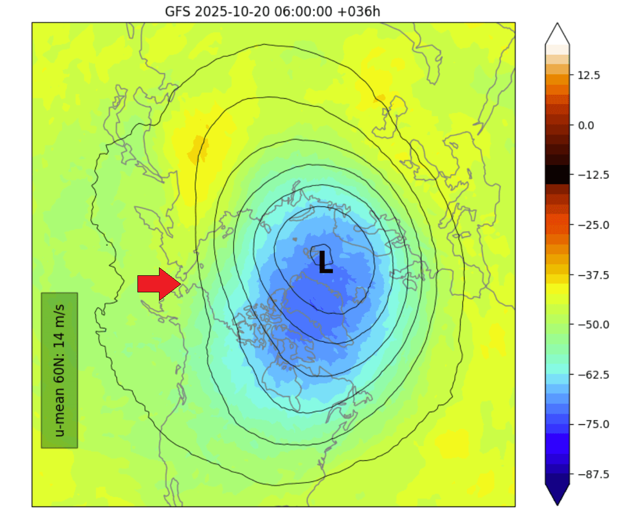
All these low values can also be seen reflected in the actual weather and the developing patterns. If we look at the Polar Vortex forecast early next week, we can see a strong high-pressure anomaly in the stratosphere still at the western side of the Polar Vortex. But as the vortex still grows in October, it starts to expand.
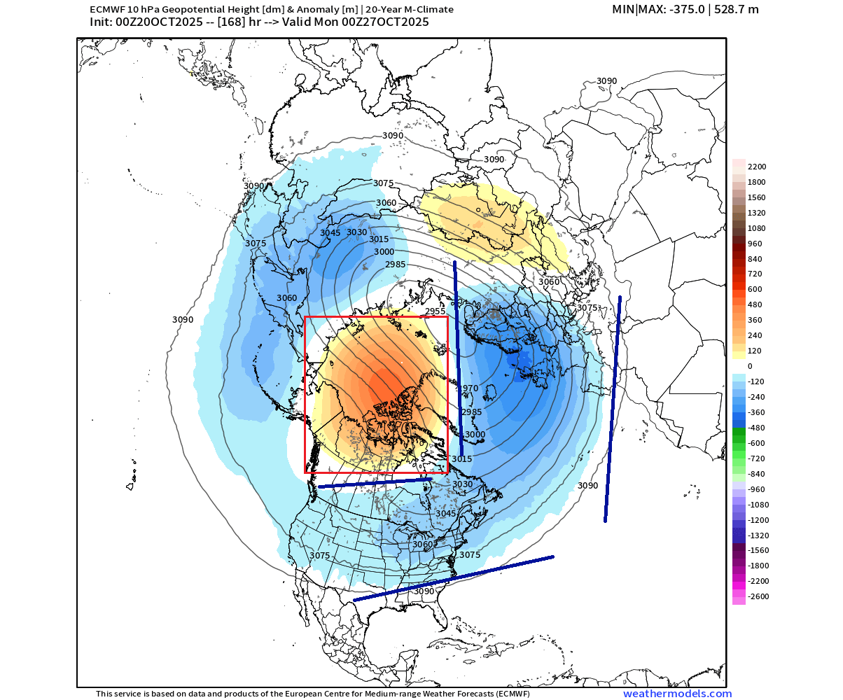
Because the Polar Vortex is growing but is blocked to the west, it starts to create an extension around it into eastern Canada and the United States. You can see that an arm of the stratospheric Polar Vortex is extending into North America as a lower-pressure anomaly in the stratosphere around the high-pressure zone.
At this point, we want to know how this reflects in the lower levels and our daily weather?
First, we can look at the pressure pattern for early next week in the lower levels. The forecast clearly shows the very weak and disrupted circulation. A high-pressure anomaly is forecast to expand over the polar regions, creating a very similar pattern as in the stratosphere higher above.
The normal circulation is disrupted, which displaces the low-pressure areas into the central and eastern United States, the North Pacific, and also Europe. A pattern like this in mid-winter would bring a very good winter period to the mid-latitudes.
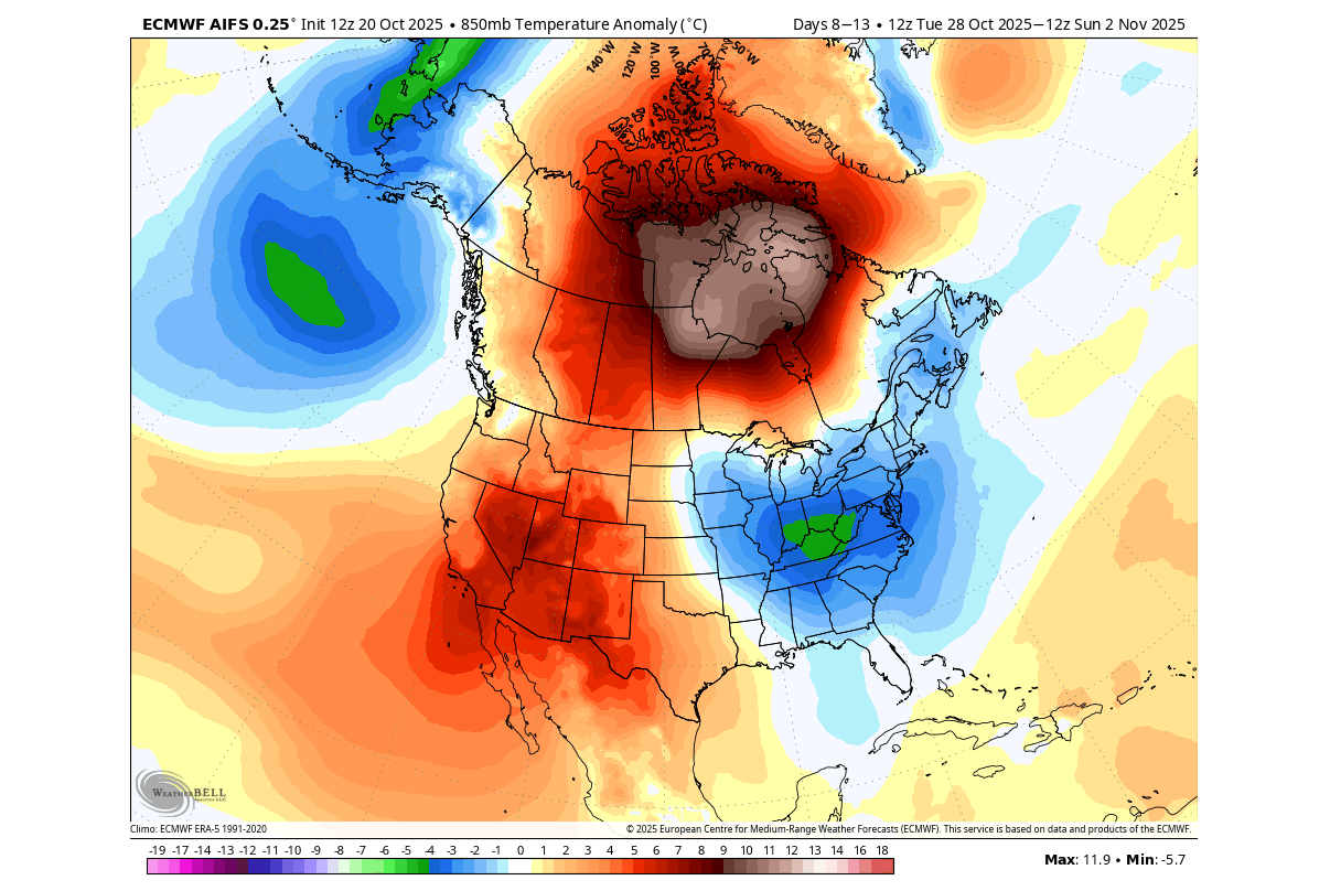
Looking at the temperature pattern for the same period, you can see an important cold anomaly over the eastern United States and far eastern Canada. That is linked to the displaced “arm” of the Polar Vortex and the extensions in the stratosphere that we showed earlier above. At the same time, temperatures remain above normal in Canada under the high-pressure system over the west-central United States.
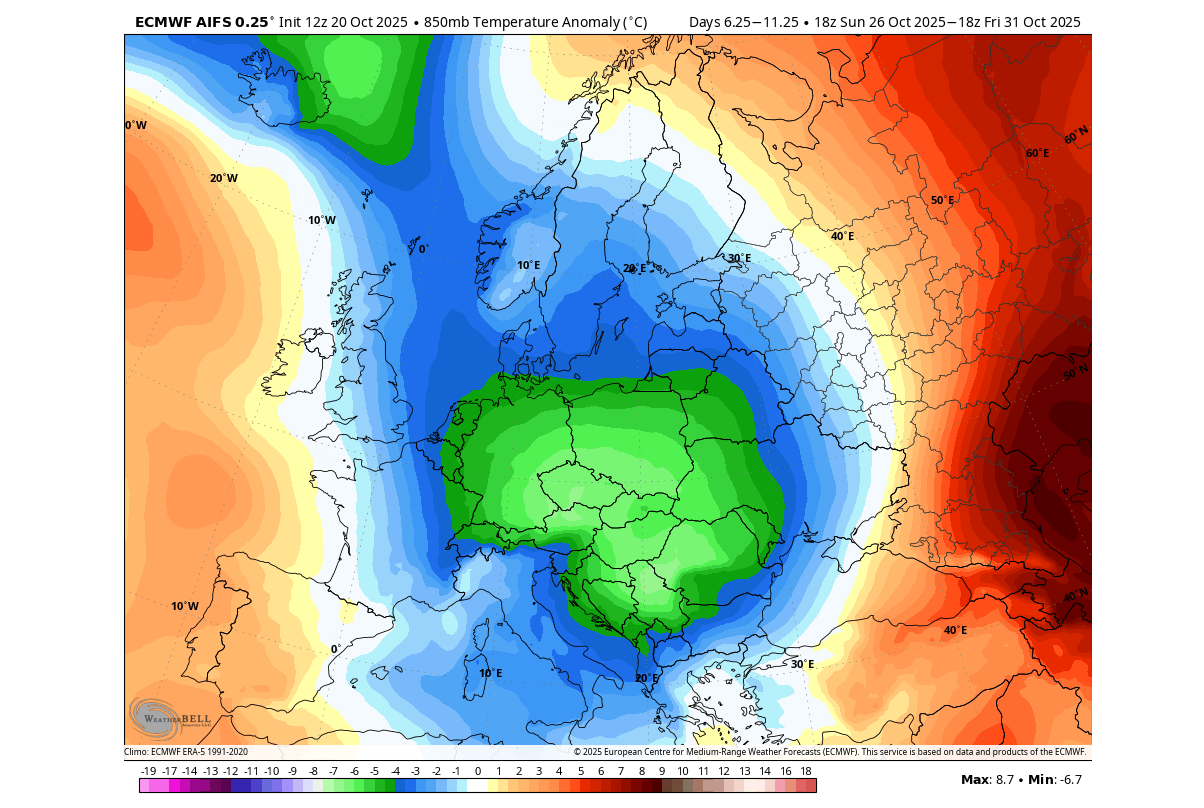
Looking closer at Europe, it is also expected to receive a round of colder air due to the heavy disruption of the lower Polar Vortex. Again, if this were in mid-winter, such a pattern would bring along cold air and snow.
But there are indications that a weaker Polar Vortex will continue deeper into Fall. So chances for more cold over the United States or Europe will slowly increase, as long as the Polar Vortex remains weaker or disrupted.
POLAR VORTEX EXTENDED FORECAST
As we have seen, the stratospheric disruptions are expected to last at least this month. We can use the extended range GEFS forecasts to see how the latest predictions show the Polar Vortex disruption to evolve in the coming month.
The first clear sign that something is off with the Polar Vortex can be seen in the stratospheric temperature forecast below for early November. While you can see a clear cold core over the eastern side, there is a stratospheric warming anomaly present on its western side, limiting its power-up.
The high-pressure anomaly still exists over the same western side of the Polar Vortex, covering Canada and the polar regions. These events are sometimes called a “Canadian Warming”. This anomaly keeps impacting the shape of the Polar Vortex, forecast to keep extending its southern arm into North America.
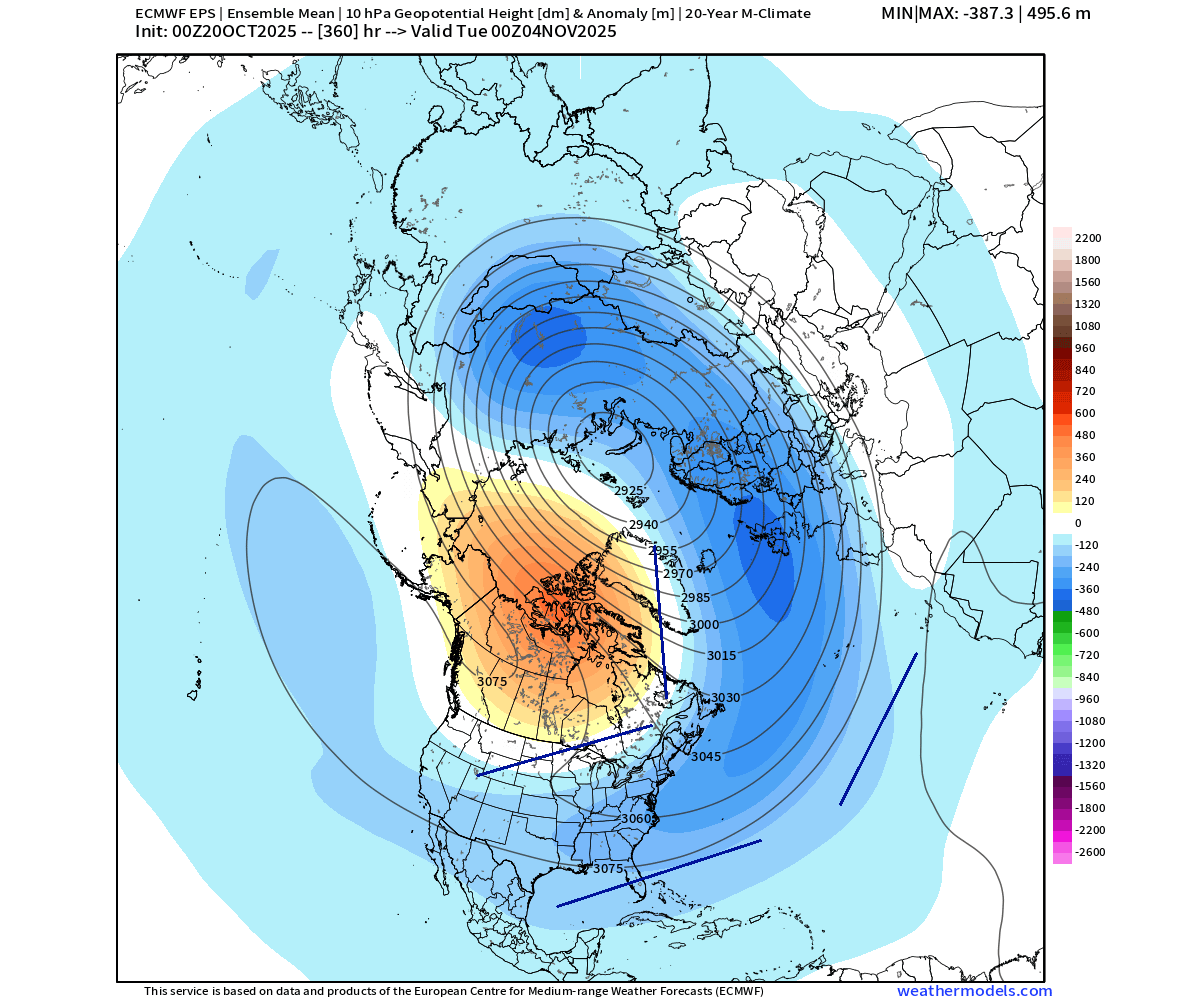
Below is the lower-level pressure pattern forecast for the same extended period. You can see this elongation reflected down to the lower levels. The high-pressure area is over the polar regions, disrupting the overall circulation, enabling low-pressure systems to take over the mid-latitudes.
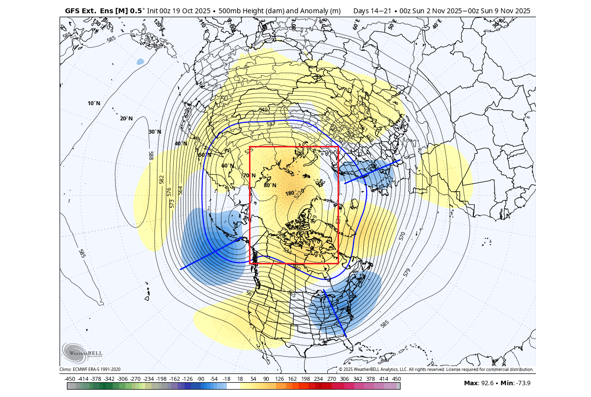
This just shows how important it is to follow the development at all levels of the Polar Vortex any day of the cold weather season. Low-pressure areas can develop over the east-central United States, southeastern Canada, and parts of Europe.
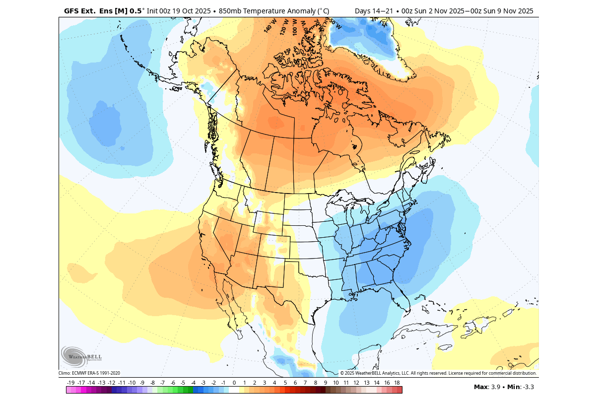
The temperature anomaly forecast for the same period shows an interesting pattern for the United States and Canada. You can see the cold anomaly over the central and eastern United States continuing into November. At the same time, Canada will still be impacted by the high-pressure anomaly and above-normal temperatures.
This again shows just how much potential these weak Polar Vortex events have to bring anomalous weather and, in many cases, a proper cold/snowy week or two over the eastern United States and Canada during winter.
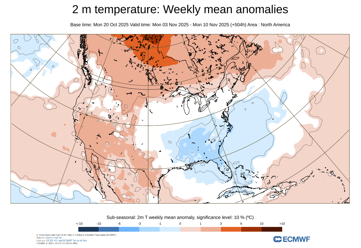
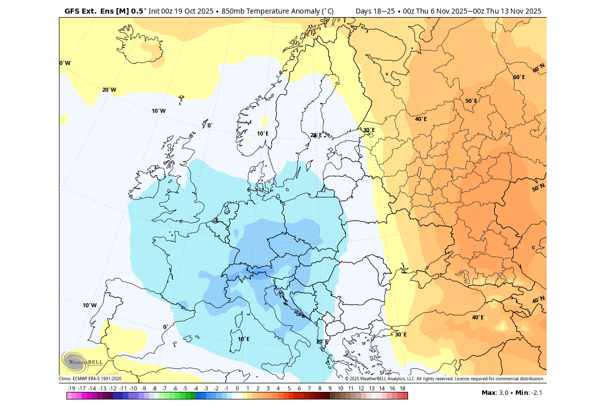
The ECMWF extended forecast also shows a more direct impact over the eastern United States, with colder air expected in the first half of November. This is just the latest trend, but it can already show us the potential weather implications of the Polar Vortex changes.
Europe also shows a continued cooler trend going into November, as the disrupted lower Polar Vortex allows a low-pressure area to build over the region.
These current events tell an important story of how important the Polar Vortex is at any point in time, especially if you want proper winter weather. And we have seen this in the past many times before.
IMPACTS ON WINTER 2025/2026
Usually, such abnormal early Polar Vortex development can also influence long-range weather development. In some cases, these anomalies do not mean much. But we can actually find another similar event in October, dating back to the 1981/1982 season.
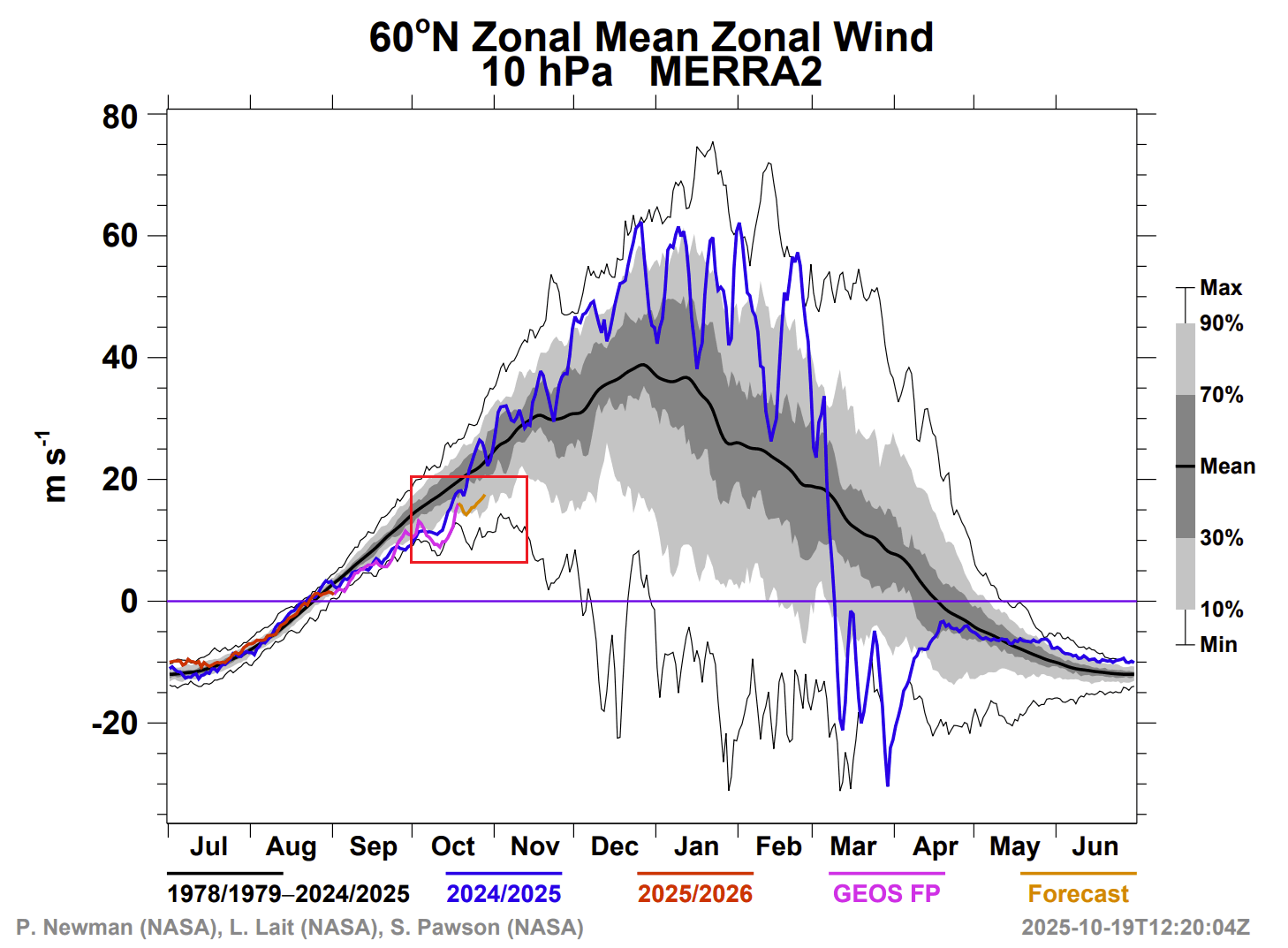
Below is NASA’s stratospheric wind analysis/forecast for the current 2025/2026 season. Ignore the blue line, which shows the last year. You can see that we were drifting at record-low values early in the month and are now running well below normal.
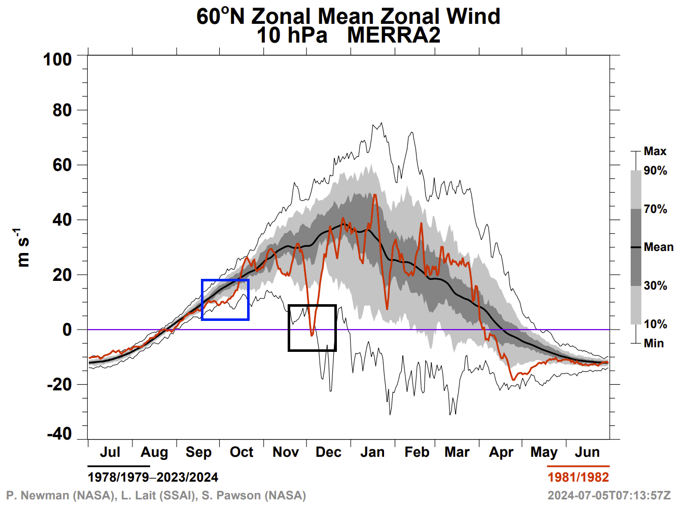
Below is the same NASA analysis for the 81/82 season. You can see the same pattern in October, with half the month running at record-low values. The Polar Vortex did spin up to around normal values, but was never actually strong. In early December, the stratospheric winds got reversed due to a Sudden Stratospheric Warming event, which set the tone for the rest of Winter.
Below is the pressure anomaly pattern for this specific winter. You can see a high-pressure anomaly over the polar regions, a clear sign of a disrupted polar vortex. This allowed the colder polar air to escape more easily out of the polar regions and into the mid-latitudes.
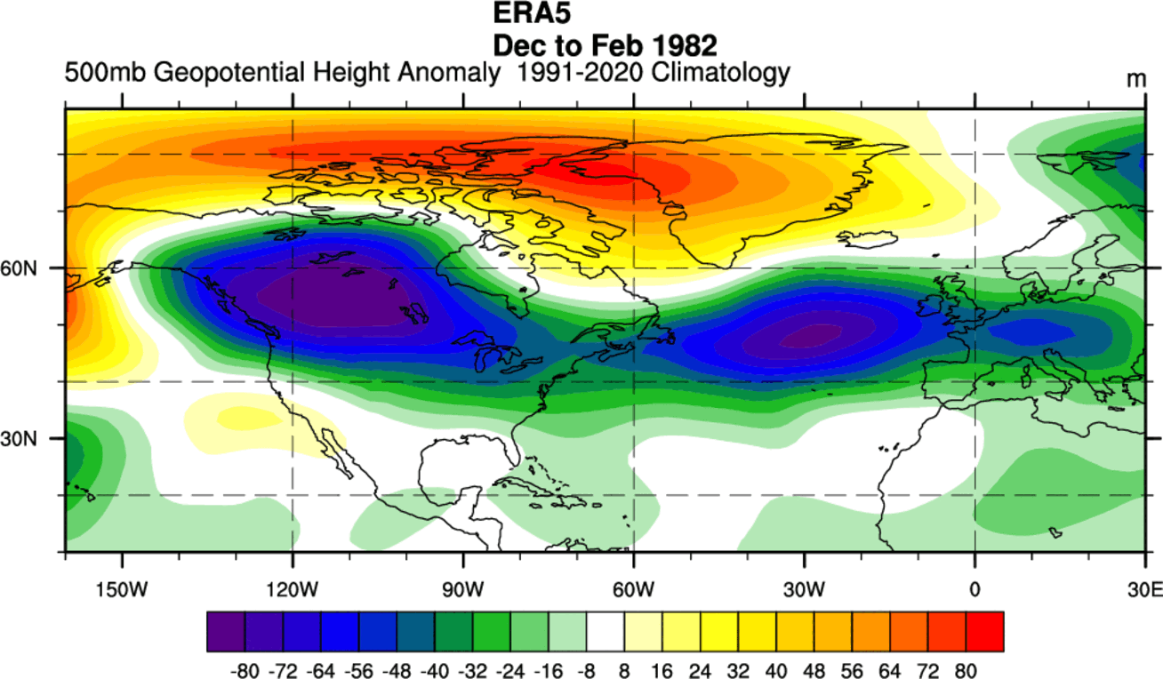
The low-pressure areas were strong and covered Canada and the United States, and extended all the way over the Atlantic.
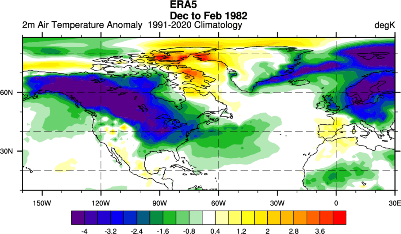
Looking at the surface temperature analysis for the same period, we can see the resulting cold air anomalies over much of Canada, expanding into the northern and eastern United States. Cold air also escaped into Europe.
This is probably one of the more typical good winter scenarios for the eastern United States, and it was largely aided by the Polar Vortex and its disrupted dynamics.
We have the long-range ensemble forecast for the Polar Vortex available, and below you can see that it shows below-normal strength for the first part of winter. The black line is the actual forecast. While we can’t expect this range to show a polar vortex collapse event, it shows a clear weakening.
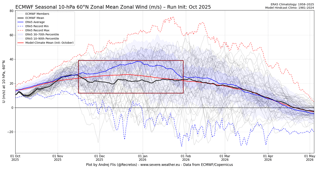
Of course, nobody can guarantee or even say that we will now have the same cold pattern in the upcoming winter as in 81/82. But we are looking at how past anomalies and unusual developments have continued into the following Winter, reminding us how small changes can have a far-reaching impact.
The main forecast images in this article are from WeatherBell and WeatherModels.com, using a commercial license.
We will keep you updated on the global weather pattern development, so bookmark our page. Also, if you have seen this article in the Google App (Discover) feed, click the like button (♥) there to see more of our forecasts and our latest articles on weather and nature in general.
Don’t miss: