A Stratospheric Warming event has disrupted the Polar Vortex and will now send its largest lower core into North America. This Polar Vortex core is expected to bring snow and cold across a large part of the United States and southern Canada in the coming days and weeks. It will also affect other parts of the Northern Hemisphere, but with different weather impacts.
The Polar Vortex usually locks the cold air into the polar regions. But when disrupted or collapsed, its lower cores can move farther south, creating proper winter weather where they land.
We will quickly look at how the Polar Vortex disruption occurred in the stratosphere, and how it will enable a whole Polar Vortex core to land over the United States and Canada. You will also see the winter weather changes it will bring and how long it is forecast to last.
THE POLAR VORTEX SYSTEM
You don’t need to be an expert to understand what the Polar Vortex is and how it works. In simple terms, the Polar Vortex is a name for the broad winter circulation over the northern (and southern) hemispheres.
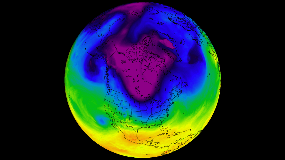
You can simply imagine the Polar Vortex as a cyclone (or a wall) spinning over and around the polar regions. It rises from the surface into the stratosphere (over 50km/30miles high), containing the cold polar air inside.
As you can see in the image below, there are two atmospheric layers that we monitor at all times around wintertime: the troposphere and the stratosphere. The first is the lowest layer, and the second is at a higher altitude. The Polar Vortex rises through both layers, but with different strength, shape, and impacts.
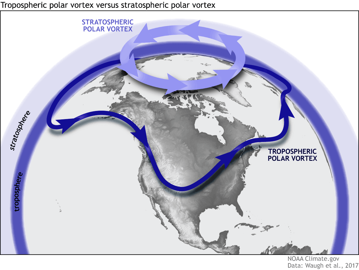
For this reason, we separate the entire Polar Vortex into an upper (stratospheric) and a lower (tropospheric) part. When the Polar Vortex is strong, it locks the colder air into the polar regions, preventing its escape, and creating milder conditions for most of the United States, Europe, and other mid-latitudes.
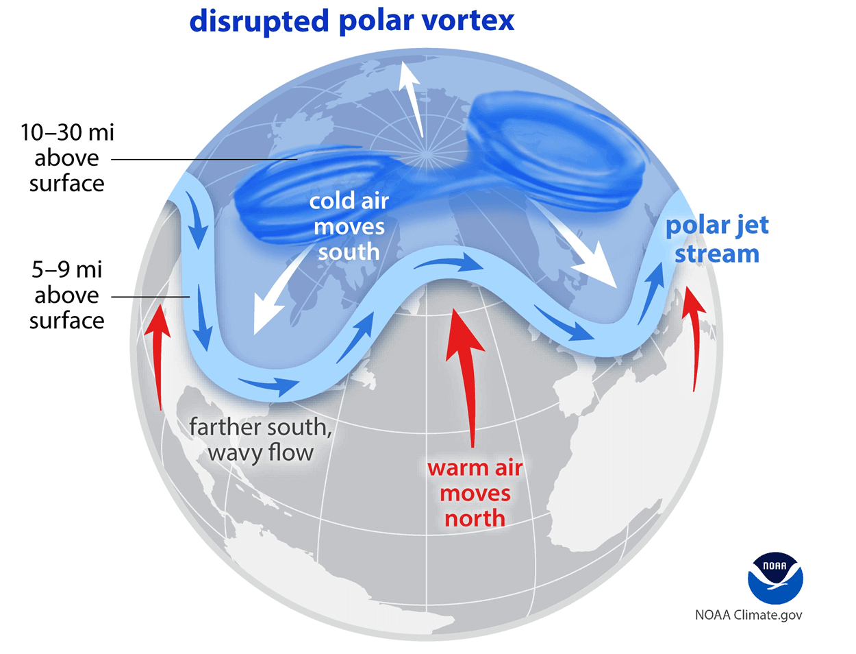
But when the Polar Vortex gets disrupted or even fully collapses, it can’t fully contain the cold air, which can now easily escape from the polar regions into the United States or other mid-latitude regions. Below is an example of how a disrupted Polar Vortex brings cold polar air into the United States and Europe.
If you prefer a warmer/milder Winter, you will like a strong Polar Vortex. But if you want proper Winter weather with cold and snow, a weak/disrupted Polar Vortex is exactly what you want to see.
To better understand what the Polar Vortex is, we produced a high-resolution video below. It shows the Polar Vortex in true 3D, giving you the clearest possible view of what it looks like during a stratospheric warming event.
The term “Stratospheric Warming” refers to the event that causes a rise in temperature and pressure in the stratosphere. That has a weakening effect on the Polar Vortex, disrupting its shape and, in some cases, causing its full collapse, releasing cold polar air into the United States and other mid-latitudes.
We will now look at the latest analysis and the currently ongoing Stratospheric Warming event, and how it will help to unleash colder weather and snowfall in the days and weeks after the event.
A POLAR VORTEX DISRUPTION
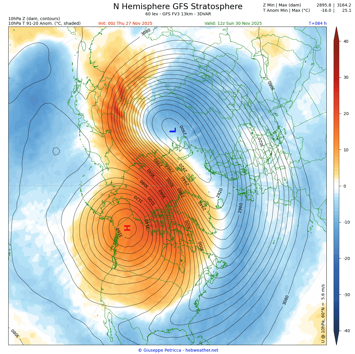
Below is the Day-3 pressure and temperature forecast for the mid-stratosphere at the 10mb level (30km/18.5miles height). You can see a very strong high-pressure area (H) in the mid-stratosphere, sometimes called the “anti-vortex”. You can also see a very strong warming wave occurring where it comes together with the Polar Vortex (L), deforming and disrupting its structure.

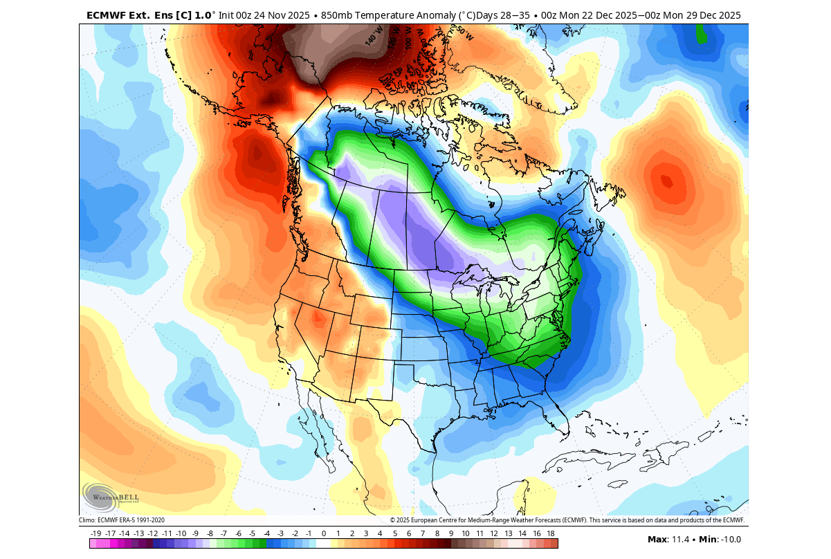
The temperature anomaly forecast for the same level/period shows how much warmer or colder the stratospheric temperatures are for this time of year. This fully reveals the stratospheric warming event, as you can see a large cross-polar warm anomaly, with temperatures far above normal around the Polar Vortex. Image by hebweather.net
Such a stratospheric warming event is quite unusual at this time of year. There are fewer than a handful of these stratospheric events recorded this early in the past 70 years, with this being the earliest on record, if confirmed by later analysis.
We can also look at the pressure anomaly for the same level/time (Day 3). This reveals the full extent of the high-pressure anomaly in the mid-stratosphere. You can see how it is squeezing the Polar Vortex and slowing it down, creating a major disruption in this layer of the atmosphere.
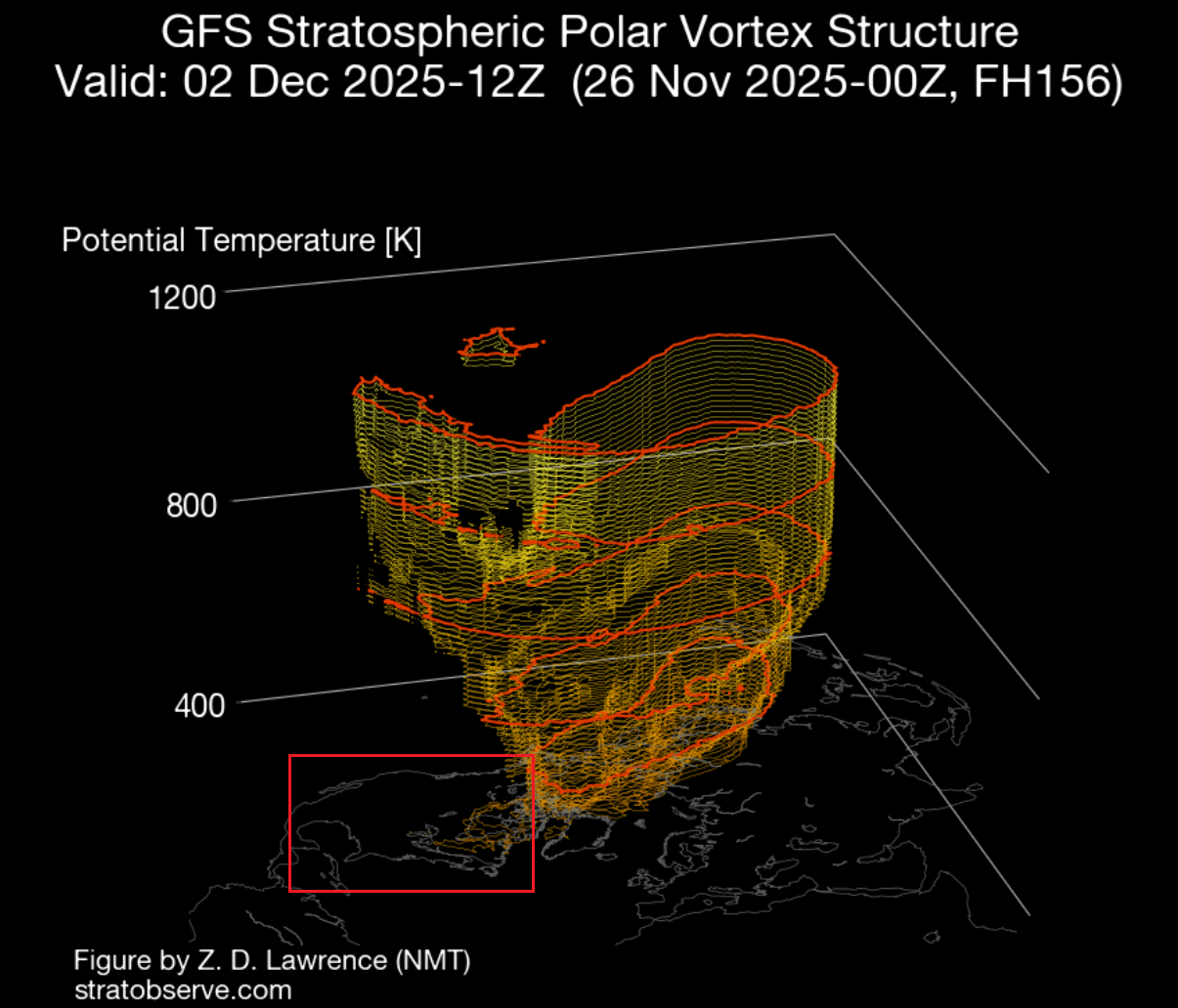
Below is also a 3D forecast of the Polar Vortex for the same time. You can clearly see a strong disruption of the Polar Vortex, with a very elongated/deformed shape instead of the more typical circular shape when it’s strong and stable.

This is the time when we can start looking for impacts at lower levels. And to find that, we first need to see signs that it’s actually making progress downwards from the stratosphere.
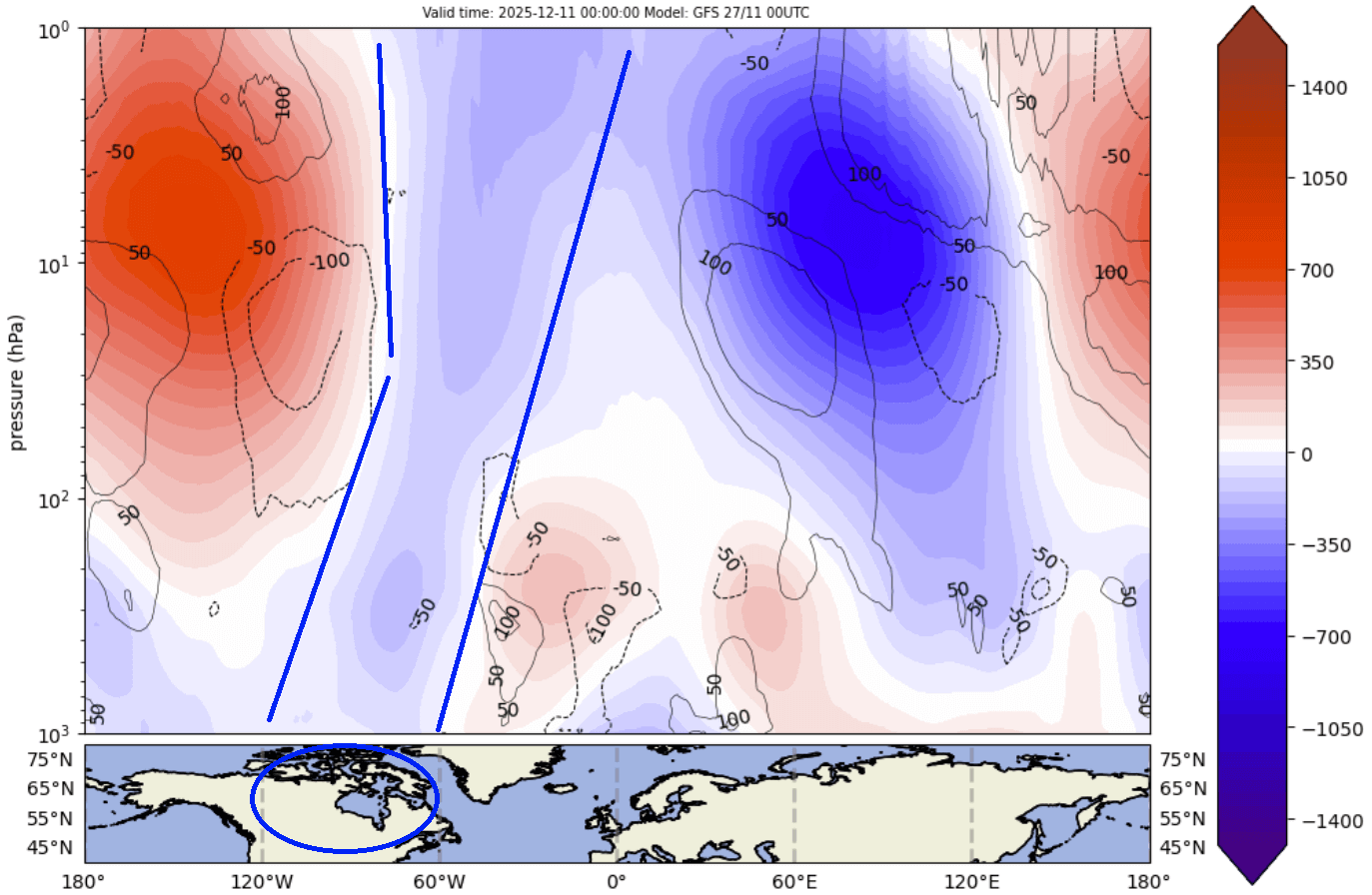
Below is a special image that shows pressure anomalies across the atmosphere (by altitude), over the polar regions. The black line marks the boundary between the stratosphere above and the troposphere below. This allows us to track upward or downward-moving pressure changes.
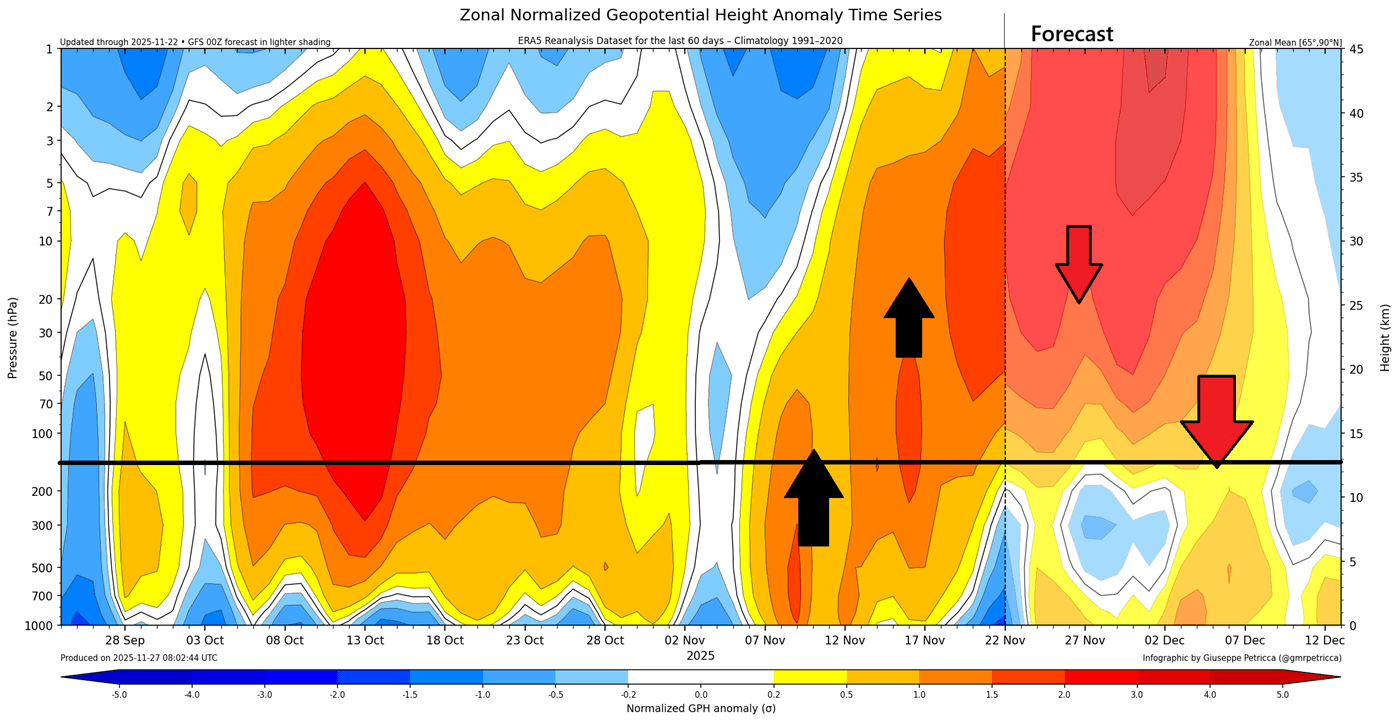
Arrows show the apparent movement of the pressure anomalies, with a clear upward movement in November that led to the stratospheric warming event. But in the forecast part, you can see the large high-pressure anomaly in the stratosphere, and its downward movement to the lower levels in December.
This gives us a clear sign that we can shift our focus to the forecast for lower levels and see the first direct weather changes in the coming days/weeks.
A COLD POLAR VORTEX CORE
We can start near the bottom of the stratosphere, at the 100mb level (16km/10miles height), with the day 14 pressure anomaly forecast. At this level, you can see a different development of the same disruption, where the Polar Vortex is actually split into two cores. Image by Weatheriscool
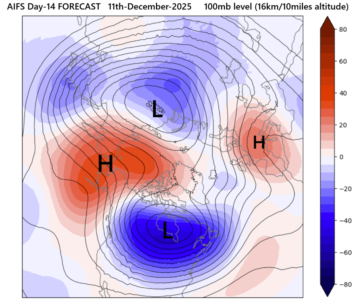
The stronger core of the Polar Vortex is pushed into North America, impacting the weather patterns below over the United States and Canada. This also has a broader impact on the overall winter circulation.
You can see this better in the 3D forecast, where the data shows a core part of the Polar Vortex reaching into North America in the lower stratosphere (marked in the image). So this way, we can see how this fits into the overall stratospheric warming event and the whole structure.
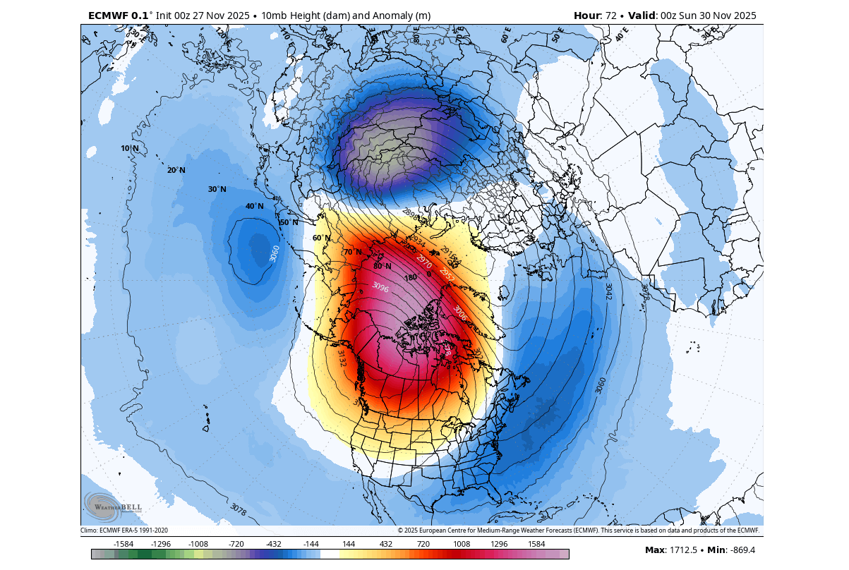
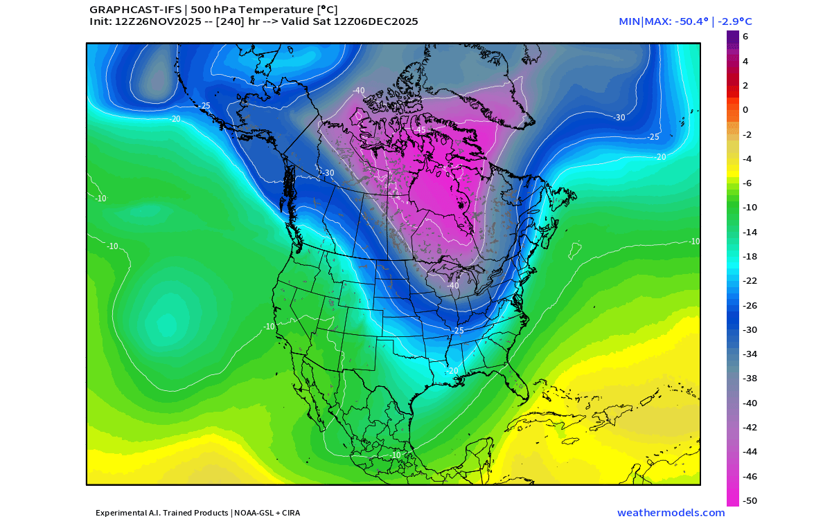
To see how this looks in the actual weather pattern, we can look at the temperature forecast data at lower levels, around 5km/3miles altitude. This way, the cold Polar Vortex core is very easily seen, extending its reach from Canada down into the central and eastern United States in early December.
Knowing where this cold Polar Vortex core is, or will be, we can see it on the vertical pressure analysis below. This goes all the way from the surface up to the top of the stratosphere. And you can see how the low-pressure area over North America is the actual core part of the Polar Vortex, split in the lower levels, but still merged at the very top.
This is the result of the stratospheric warming disruption, and also with some upward influence, which combined will split the Polar Vortex into two main cores. So, with all the data in mind, it’s now clear that we will be dealing with a true Polar Vortex core over the United States and Canada in December.
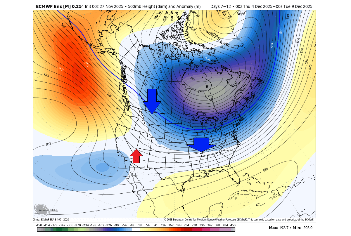
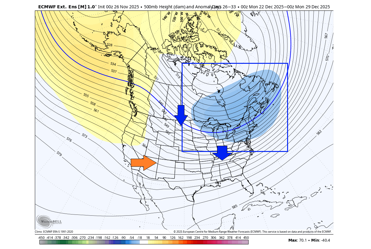
All of this creates a special weather pattern for December. Below is the 10-15 day forecast, where you can see a large low-pressure anomaly, which is the Polar Vortex core, sitting over Canada and the upper Midwest, extending also into the Atlantic. This creates a strong northerly flow into the United States.
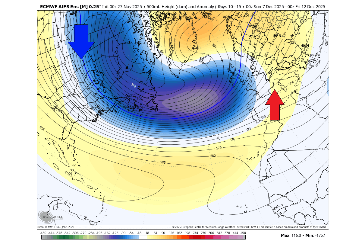
But a low-pressure system spins counterclockwise, which means that on its rear side, we get a colder northerly flow. But in front, the low-pressure system creates a milder westerly/southerly flow. This usually brings unsettled conditions over northwestern Europe, with a mild flow over the mainland.
We will now move from the high altitudes of the stratosphere to near the surface and look at the medium and extended-range weather forecasts for the upcoming Polar Vortex core period over the United States and Canada.
ARRIVAL OF COLD WEATHER AND SNOW
When you hear that “a Polar Vortex core is coming”, it’s usually just as dramatic as it sounds. These cores are essentially large, low-pressure systems that ride with colder polar air. But the amount of snowfall they bring usually depends on the available moisture, so large snow amounts are not a given.
The first signs of change will already be felt in the coming days, as a wave of cold air is forecast across much of the United States, with the bulk over the Northern Plains and the Midwest. Colder air will spread far south and will also move towards the eastern United States.
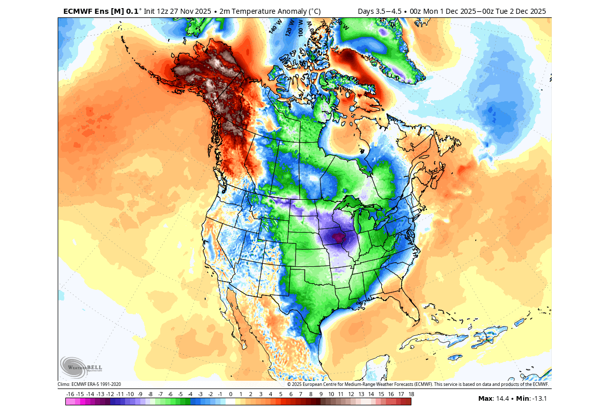
The Polar Vortex core is forecast to settle in later next week. The map below shows a large, broad low-pressure area over North America, which is the lower Polar Vortex core. With its counterclockwise spin, this will create a northerly cold flow into the northern, central, and eastern United States, transporting cold air directly down from the polar regions.
A smaller low-pressure area is forecast over the southwest, bringing a warmer southerly flow into the southwestern United States and more precipitation over California. Of course, if it actually forms, as these smaller systems are harder to properly predict than a large Polar Vortex core.
Below is the temperature forecast for 5000ft (1500m) altitude, which we use to indicate airmass movement. This forecast period is around two weeks from now, and serves as an example of how the large mass of cold is being brought into the United States by the Polar Vortex core.
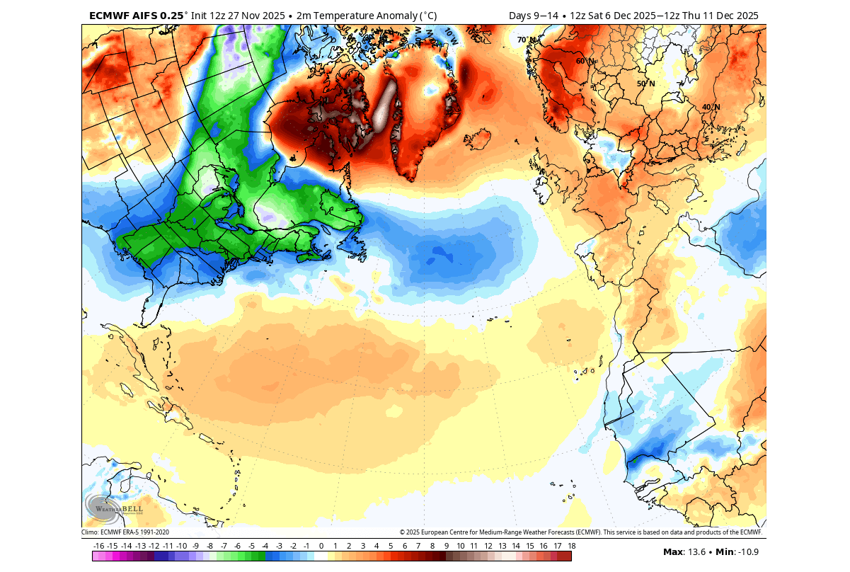
The actual surface temperature anomaly for 10-15 days from now shows a strong release of cold polar air into the northern, central, and eastern United States. This really nicely shows where the cold air is coming from, spilling across the United States and southern Canada.

This is a perfect example of the end result from a Polar Vortex core, which acts as a “pump”, for the cold polar air. We can also look at the total snowfall for the next two weeks, but we have to keep in mind that cold air alone does not mean heavy snowfall. For that, we also need moisture along with cold air.
Below is the total snowfall forecast for the next two weeks, and you can see two main areas of snowfall. One is over the western elevations, and over the northern United States and the Pacific Northwest. That is attached to the main cold air source region.
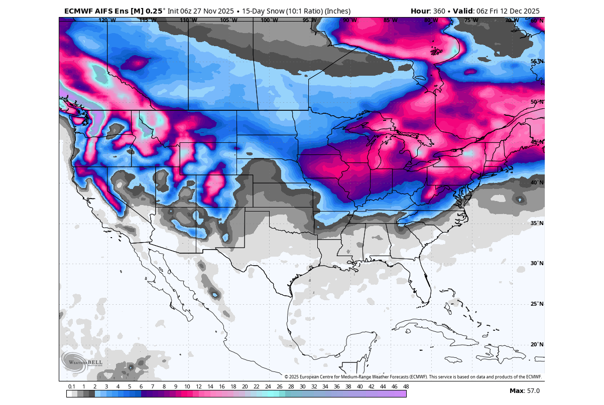
The second snowfall area is over the Midwest and the eastern/northeastern United States. This second area has good snowfall potential, as it sits in a good location relative to the Polar Vortex core, where the moisture/cold overlap is favourable.
Snowfall is also indicated over the northern and central plains, but in lesser amounts, as moisture is often a limiting factor, depending on the pattern. But keep in mind that this is not snow on the ground, but just total snowfall.
A CHRISTMAS SNOW SCENARIO
December will soon start, which means that the ECMWF extended-range forecast can already see into the Christmas holidays. And every year, when winter is about to start, many start wondering if this is the year they will have backyard snow during the holidays.
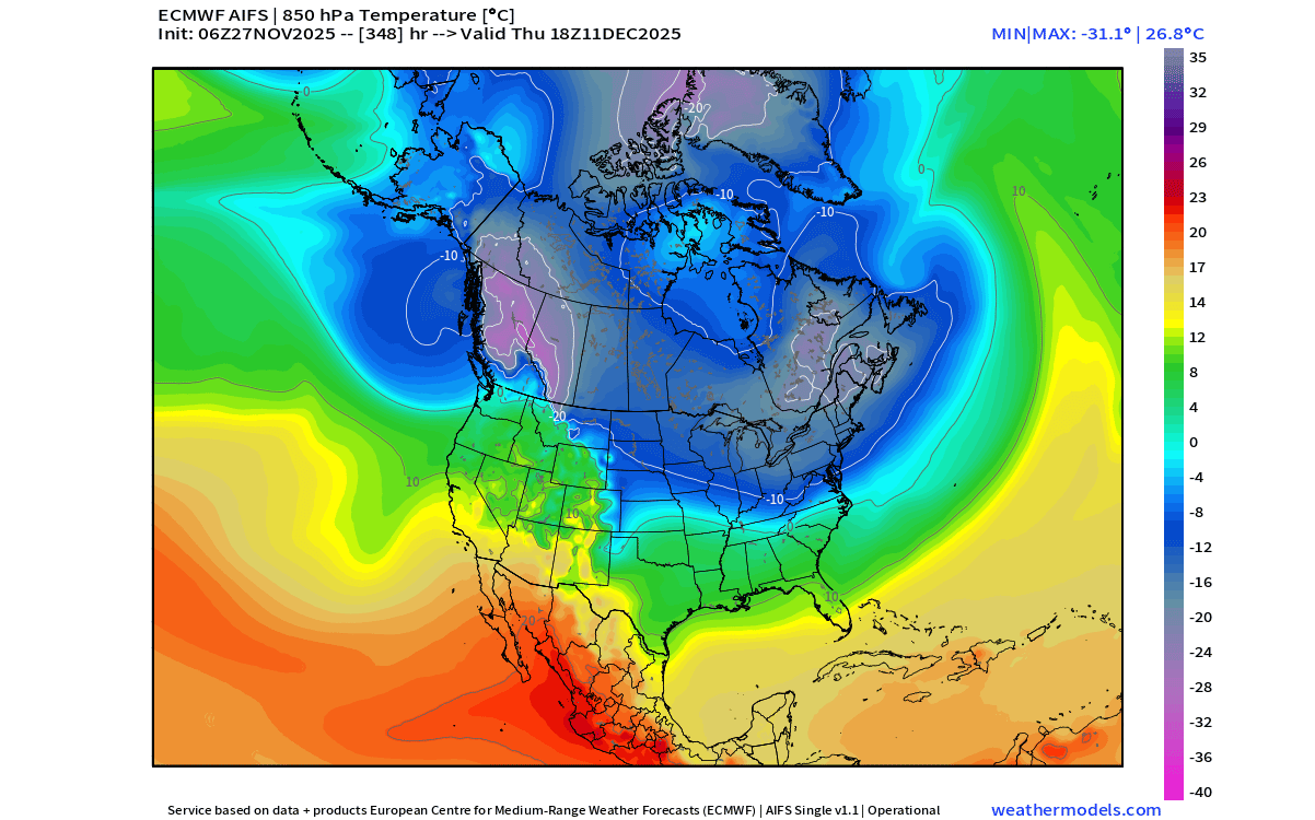
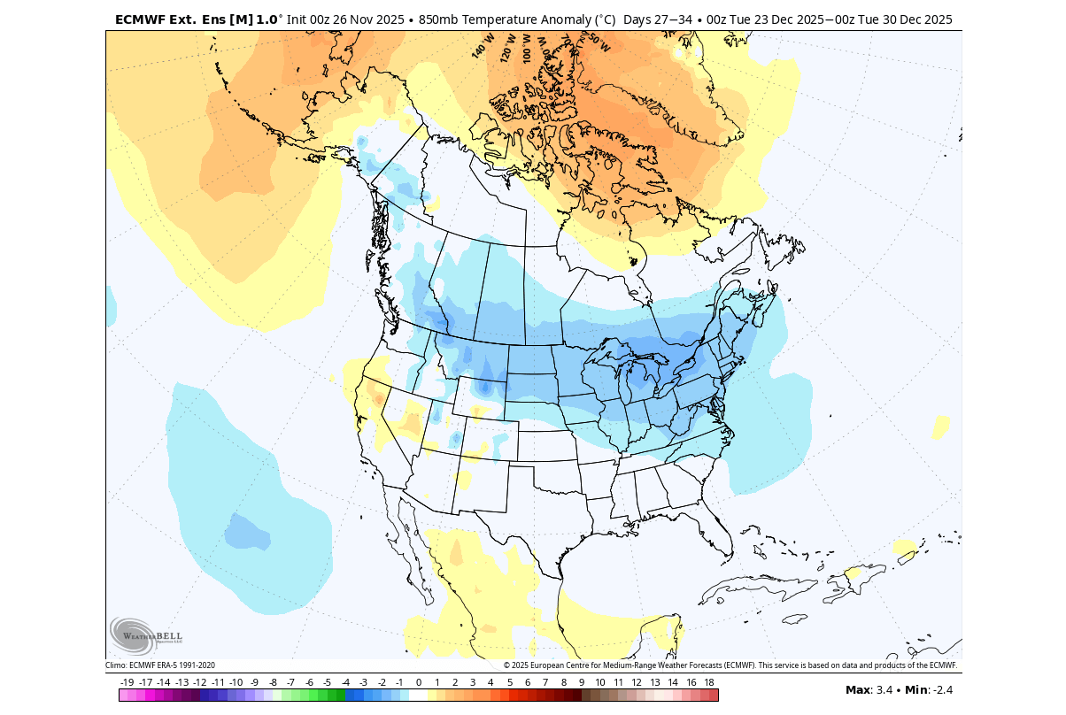
Looking at the pressure anomaly for late December, we can see that the Polar Vortex core is still over the same area. Covering the northeastern United States, upper Midwest, and eastern Canada, this is a great location for the core to bring sustained cold air down for the holidays.
This also tells us that the Polar Vortex core pattern is forecast to last deep into December. There may be a brief “reload” period during this time with some normal or warmer temperatures. But the main forecast trend shows the Polar Vortex core impacting North America throughout December.
The temperature forecast trend for late December shows that the cold air anomaly continues to spread across the United States and Canada. This means the forecast expects a stable northerly flow to persist, pulling colder air from the deep polar region and transporting it across the United States and southern Canada.
Such a pattern could greatly increase the chance of a snowy Christmas across many parts of the United States. Based on this pattern, the highest U.S. potential for holiday snowfall would be across the northwest, northern Plains, Midwest, Great Lakes, and Northeast.
This would cover the Dakotas, Minnesota, Wisconsin, Michigan, northern Indiana/Ohio, Pennsylvania, New York, and New England. The second-highest snow potential covers the Ohio Valley and central Appalachians, including southern Ohio/Indiana, Kentucky, West Virginia, and elevations of western Virginia and western Maryland.
We can also look at the single forecast for this period, which shows the strong cold air wave into the central and eastern United States for the Christmas holidays. This is just a forecast of the control run and is used only to get a more detailed idea of the potential scenarios under this weather pattern.
Of course, we have to keep in mind that this is a far extended range. But what gives us good confidence is that this is not some random forecast, but a pattern following a stratospheric warming event, backed by other events with similar Polar Vortex core movement.
We will keep you updated on the global weather pattern development, so don’t forget to bookmark our page. Also, if you have seen this article in the Google App (Discover) feed, click the like button (♥) there to see more of our forecasts and our latest articles on weather and nature in general.
The main forecast images in this article are from WeatherBell, using a commercial forecaster license.
Don’t miss: Latest long-range snowfall predictions for Winter 2025/2026