UPDATE: We are live tracking a rapidly developing Winter Storm Gianna
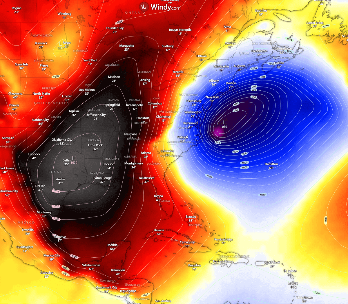
As the month closes, the Polar Vortex is triggering an explosive bomb cyclone, with a Nor’Easter Winter Storm Gianna unfolding off the U.S. Southeast coast. A rapidly deepening cyclone takes place as a powerful subtropical jet streak collides with a sharply displaced lobe of Arctic air diving south from Canada.
The result is the potentially high-impact surface low undergoing rapid intensification, with central pressure forecast to fall more than 24 millibars in 24 hours. This is known as a bombogenesis meteorological process.
It appears likely that Gianna will bring violent winter weather across the Outer Banks of North Carolina. Severe winds exceeding 65 mph, blizzard conditions, coastal flooding, and severe travel disruptions are expected to occur where these conditions develop.
While the East Coast could see more heavy snowfall, blizzards, severe winds, and coastal flooding from a strengthening Nor’easter, the Southeast and Florida face a sharp, potentially record-breaking Sunday and Monday low temperatures as an Arctic air mass spreads deep south behind the Winter Storm Gianna.
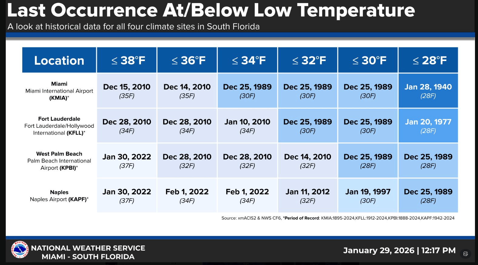
Florida is forecast to experience one of the coldest morning lows in decades on Sunday. With freezing temperatures down to Miami. The last subfreezing temperature in southern Florida occurred in December 1989 during one of the most exceptional cold spells.
Jan 31st, 17:45 UTC update: Evening visible satellite view of rapidly developing Winter Storm Gianna
Polar air mass is now advancing into the Gulf region, with a typical cloud street appearance over the sea. The Winter Storm Gianna continues to rapidly intensify. Expected to become a powerful bomb cyclone by Sunday morning as it tracks east of the Outer Banks, North Carolina.
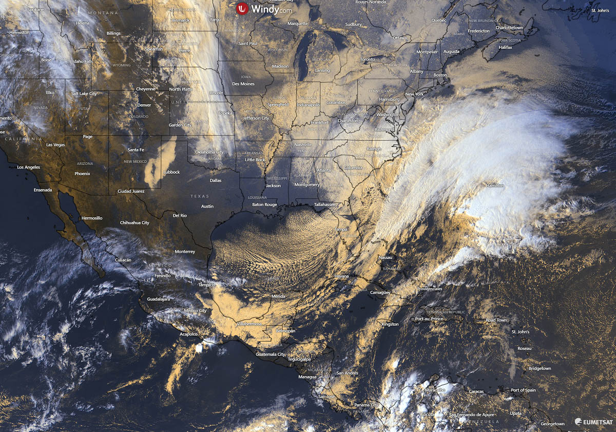
A major snow blizzard is developing across eastern North Carolina, with conditions rapidly worsening as winds and snowfall rates are increasing.
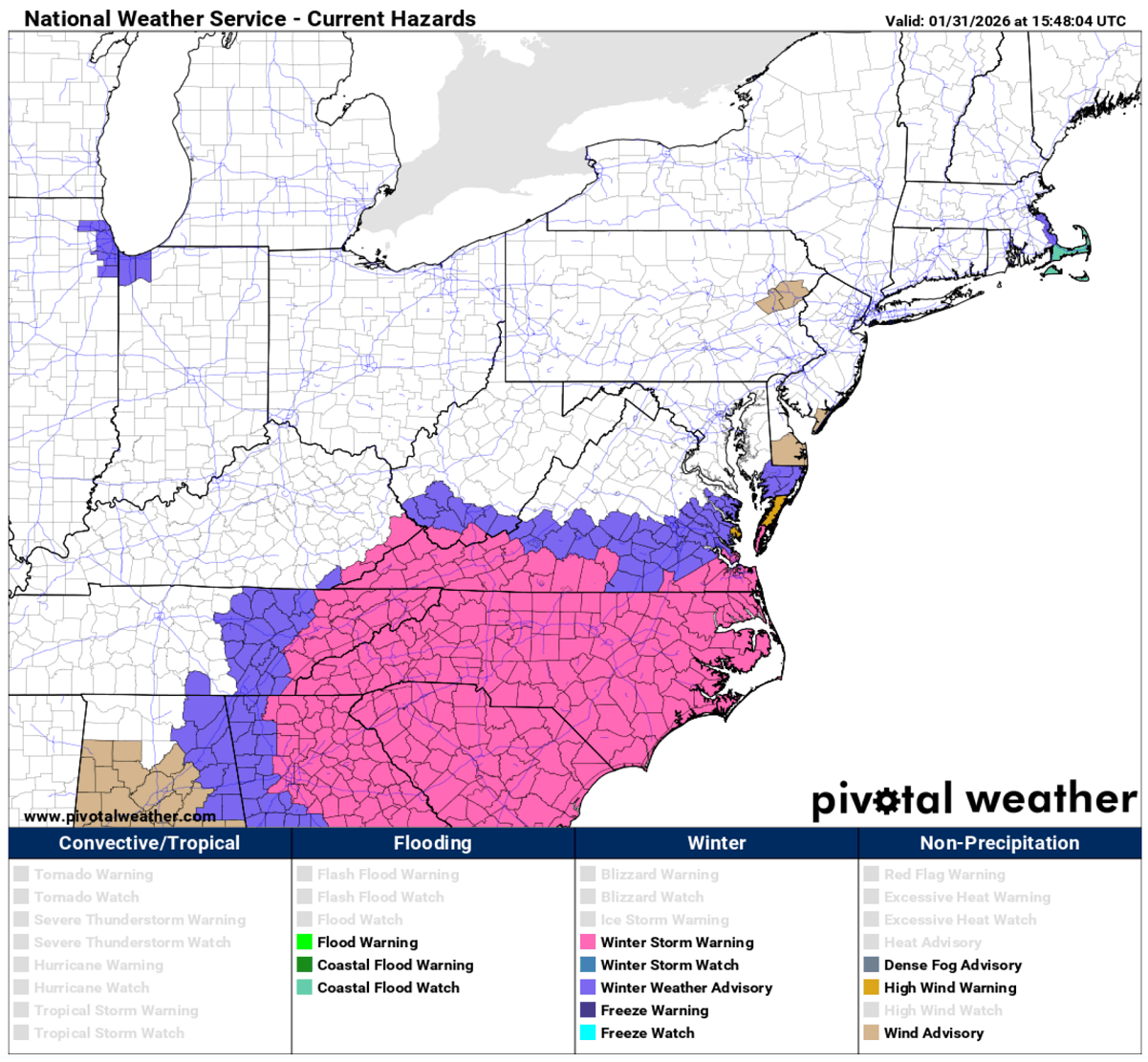
Jan 31st, 15:00 UTC update: Winter Storm, Blizzard, Flood, and Freeze warnings are in effect
Here are the official warnings issued by local and regional NWS offices for the event. Winter Storm, Blizzard, Flood, and Freeze warnings are in effect.
Snowfall rates may exceed 1″- 2″ per hour during the peak of the storm Saturday Night through Sunday morning. Whiteout conditions expected.
● Blowing and drifting snow is likely, particularly in open areas and where there is exposure to north winds. Very poor visibility will result.
● Travel may be treacherous and potentially life-threatening.
A band or bands of heavy snow are likely to set up in Eastern NC
● This axis of heavier snow is likely to be adjusted and could potentially be ANYWHERE over Eastern NC
● Blizzard conditions POSSIBLE over Outer Banks, Downeast, and open areas of the Albemarle- Pamlico Peninsula.
Peak Wind Gusts:
○ Outer Banks: 55-70+ mph
○ Rest Of Eastern NC: 40-55 mph
○ Tonight – Sun Morning
● Impacts:
○ Scattered power outages and tree damage in coastal areas
○ Blowing and drifting snow will make travel extremely dangerous or impossible at times
Coastal flooding: Moderate to locally significant impacts expected
● Oceanside: A combination of high water levels, above normal tides, and wave run up, will lead to 2-4 ft of inundation around high tide (Sunday AM high tide the highest)
● Soundside: Greatest impacts expected across Hatteras Island early Sunday morning
● Travel impacts likely along vulnerable sections of NC-12, south of Oregon Inlet
Moderate to locally significant impacts are likely soundside along Ocracoke and Downeast Carteret
● 2-4 ft of inundation (above ground level) expected tonight into Sunday morning
● Minor flooding impactsare expected adjacent to the lower Neuse River below New Bern
● 1-2 ft of inundation (above ground level), due to strong NE winds
A Wind Advisory is in effect through 7 AM Sunday morning for winds frequently gusting 35 to 45 mph and occasionally over 50 mph. Winds gradually diminish on Sunday, but breezy/gusty conditions will continue much of the day.
A Freeze Warning and a rare Extreme Cold Warning are in effect for all of east central Florida tonight into Sunday morning and Sunday night into Monday morning.
Dangerous wind chill values of 9 to 15 degrees and a hard freeze with low temperatures in the 20s are forecast for Sunday morning, and wind chill values of 17 to 20 degrees and a hard freeze with low temperatures in the 20s are forecast for Monday morning. Additional watches/warnings for the following nights may be needed.
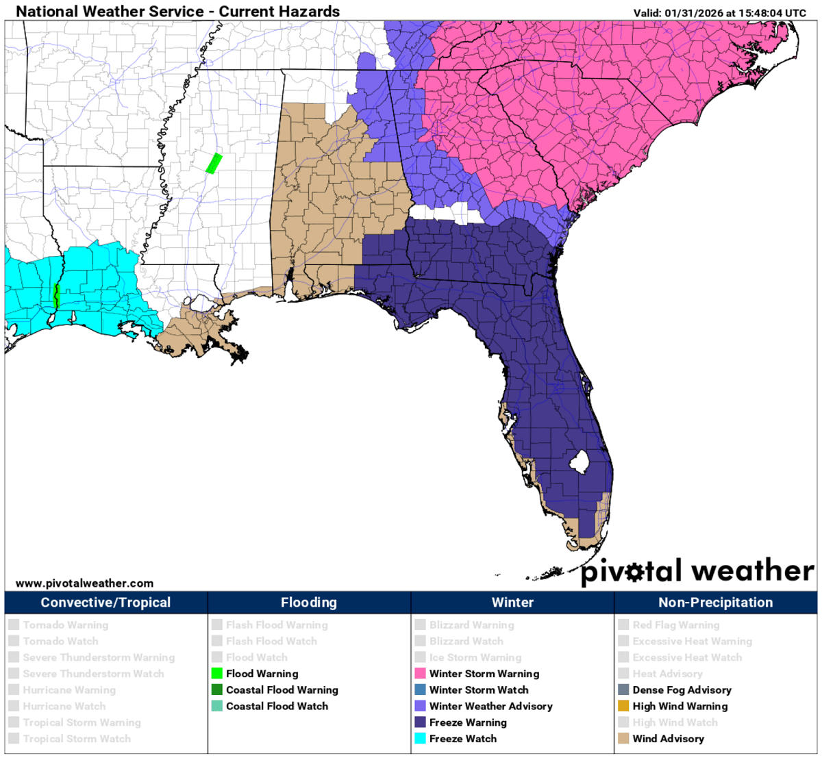
A Gale Warning is in effect for rapidly deteriorating and dangerous boating conditions through Sunday afternoon as winds increase and seas build; strong gale-force gusts are likely. Mariners should remain in port. Poor to hazardous boating conditions will linger into early next week. A Small Craft Advisory has been issued for all the central Florida Atlantic waters starting Sunday afternoon. This will likely need to be extended.
Jan 31st, 14:00 UTC update: Deep Polar low visible on water vapor satellite, bombogenesis underway off the Southeast coast
Here’s the latest water vapor satellite over the CONUS. A deep upper low is digging south across the Southeast U.S., producing heavy snow across the western Carolinas and the Appalachians.
The Arctic air mass is clashing with the subtropical air mass over the Gulf, triggering rapid cyclogenesis. This storm will develop into a powerful Nor’Easter bomb cyclone overnight.
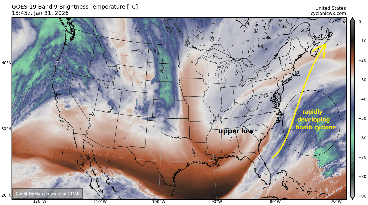
Heavy snow with blizzard conditions is expected to develop across the Outer Banks of North Carolina as the storm intensifies.
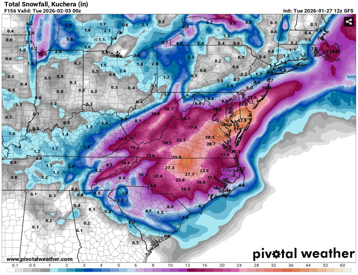
Jan 31st, 13:00 UTC update: Record snow amounts across eastern North Carolina likely – 12-15″ by Sunday night
A band of heavy snowfall will develop along the eastern South and North Carolina with the most abundant amounts near the coastal areas, and across the Outer Banks. There, heavy snow will combine with intense winds, resulting in whiteout conditions and blizzards.
12-15″ will be possible from Wilmington, NC, across the Outer Banks, which is an extremely high amount of snow, on the historic levels.
Additional snow across western portions of both states will develop as a descending Polar upper low moves across the region.
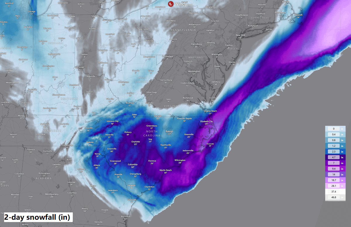
From the perspective, the last time Eastern North Carolina received 12″ or more of snow was more than 35 years ago, in December 1989 or March 1980. The impact of Winter Storm Gianna is expected to be historic for the area.
Jan 31st, 12:00 UTC update: Intense snow blizzard will develop across the Outer Banks of North Carolina
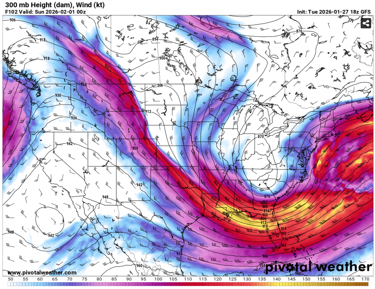
A powerful Atlantic cyclone developing offshore of the Carolinas could produce a well-defined wind maximum, known as a stinging jet, with the most intense winds, with gusts of 100–120 mph expected roughly 200 miles offshore. The Outer Banks will experience strong gradient winds of 50–70 mph.
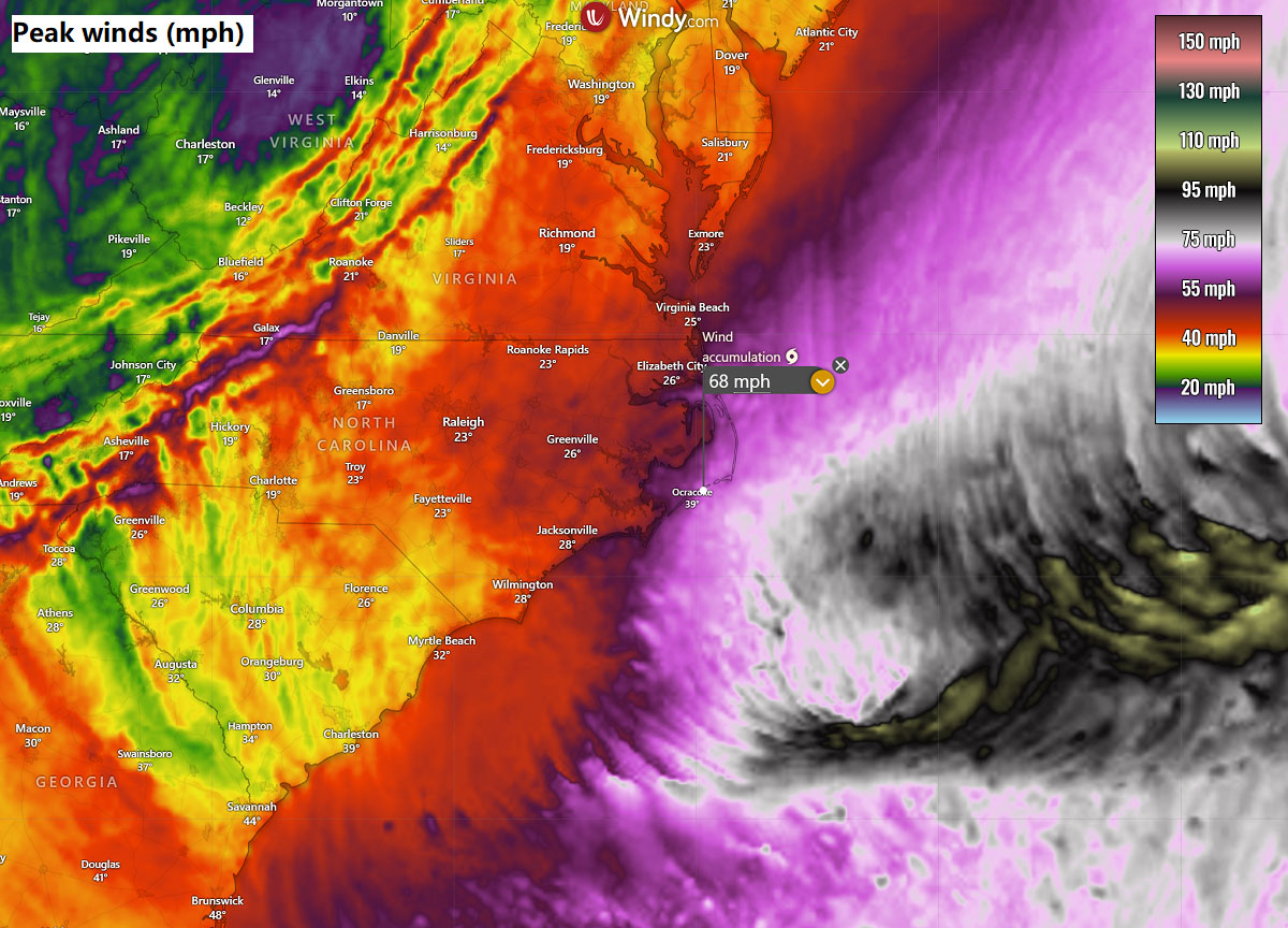
Sting jets form within the comma-head region of explosively deepening cyclones, where evaporative cooling in the dry slot accelerates descending air, transporting high-momentum winds toward the surface. The current storm is undergoing rapid cyclogenesis, deepening at nearly twice the bombogenesis threshold, increasing the likelihood of a compact but violent mesoscale wind maximum over the open Atlantic.
This setup strongly resembles the April 2nd, 2019, offshore Nor’Easter winter storm event that also featured a pronounced sting-jet signature east of the coast.
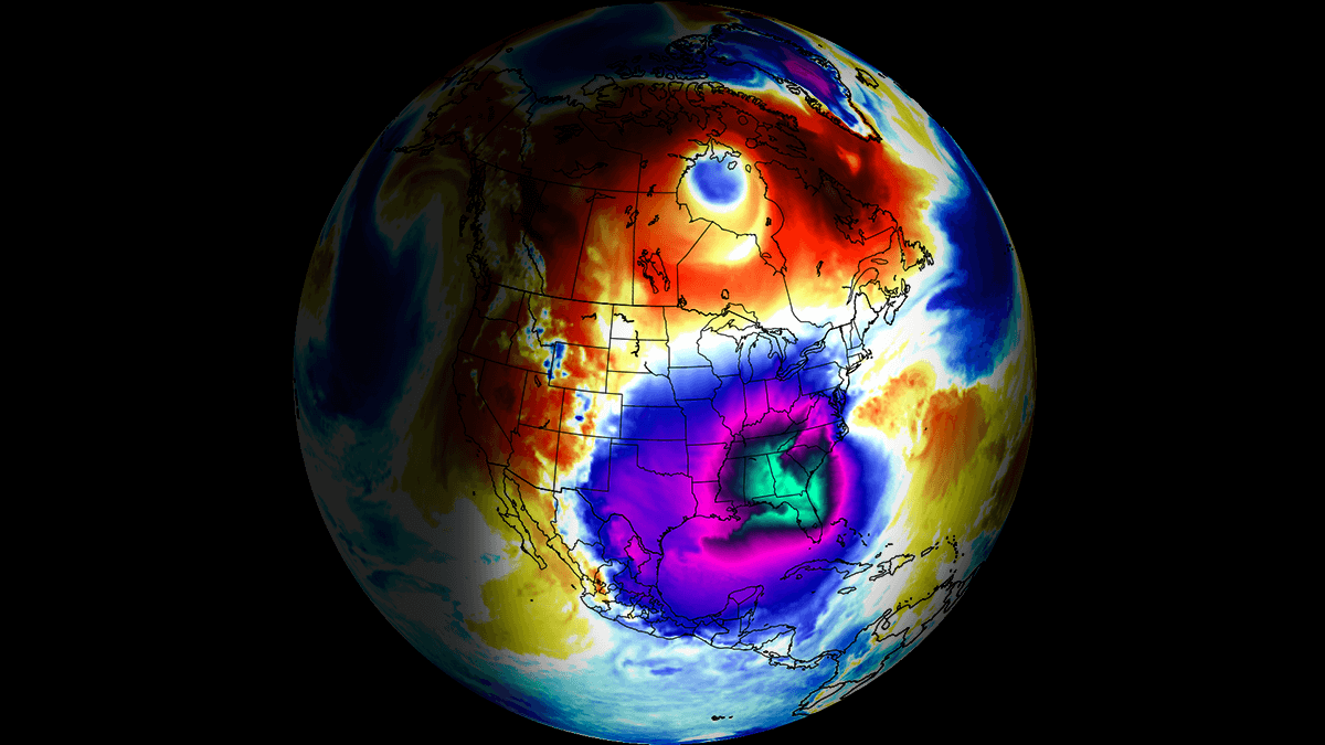
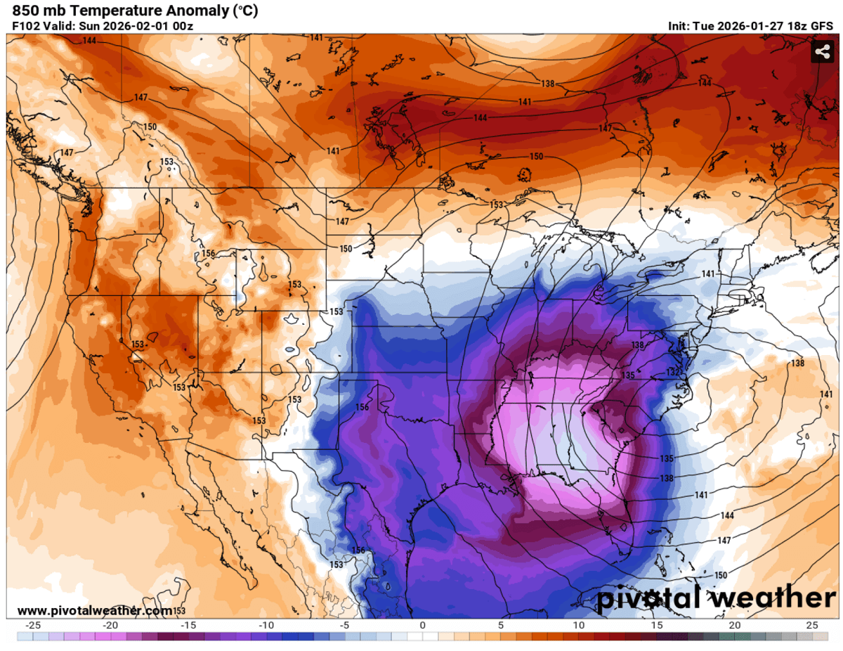
Jan 31st, 11:00 UTC update: Large Arctic cold outbreak spreading south across the U.S.
An impressive temperature picture across the United States and Canada this Saturday. A large Arctic cold pool is visible, fast-progressing across the continent, reaching the Gulf Coast and Florida as well.
As cold air moves north from the warmer south and collides with the subtropical air mass and jet stream, it results in rapid surface cyclogenesis off the Southeast coast. Winter Storm Gianna is in progress.
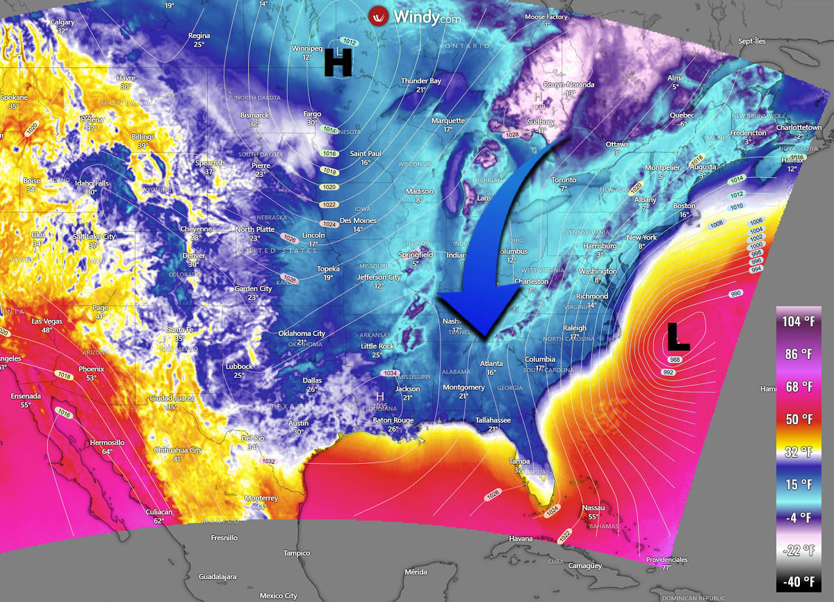
The frigid cold will continue to spread south through Sunday and Monday, resulting in an air mass that hasn’t been this low over the eastern Gulf Coast and Florida for decades. Southern Florida has not seen subfreezing temperatures since December 1989.
Morning lows across the Southeast will push temperatures into the mid-10s as far south as central Mississippi, Alabama, and Georgia, with temperatures in the single digits further north. The Gulf Coast should expect morning temperatures on Sunday and Monday in the low 20s.
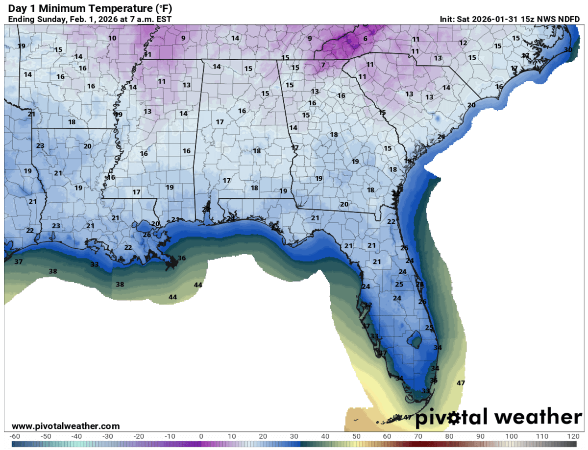
Mid-20s are forecast across central Florida and subfreezing temperatures in Miami and interior areas to the southwest. Severe frost is expected.
The reason is the significant disruption of the Polar Vortex, which is releasing a secondary wave of deep Arctic air intrusion behind the bomb cyclone storm Gianna’s primary circulation. A full-scale displacement of Arctic air into the East and Southeast U.S. brings a prolonged hard freeze.
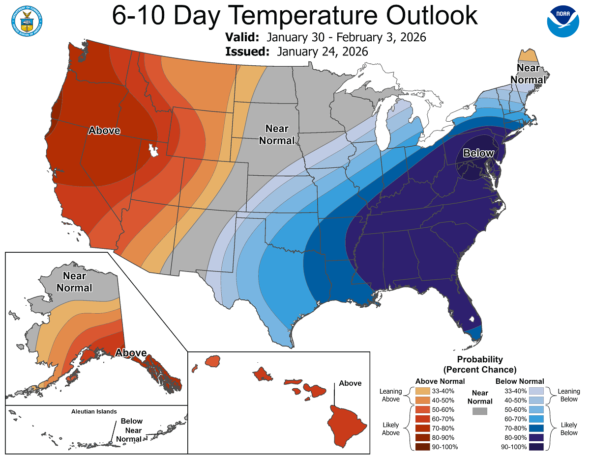
According to the NOAA 6-10 day temperature outlook, temperatures will remain below normal for at least another week, with dangerous wind chills across the East Coast as the Nor’Easter forms over the weekend and winds increase.
Before we dig into the details of the potentially impactful new Winter Storm Gianna associated with the explosive Nor’Easter bomb cyclone, it is essential to understand the background mechanisms governing the Polar Vortex.
Note that this is the primary driver of rapid weather changes and intense Arctic outbreaks across Canada and the United States during winter, bringing extreme cold deep into the South, toward the Gulf Coast.
What is the Polar Vortex?
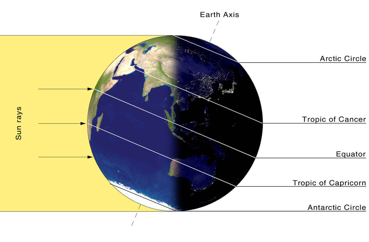
The Earth’s atmosphere has six layers. Most of the dynamics of our daily weather occur in the lowest two layers of the atmosphere, the troposphere and the stratosphere.
The troposphere is the layer closest to the Earth’s surface. It is about 12 km deep and extends from the ground up high into the sky. Depending on where you live, its depth varies from around 8 km to almost 20 km. The troposphere is deepest over the equatorial region and becomes much thinner over the North and South poles.
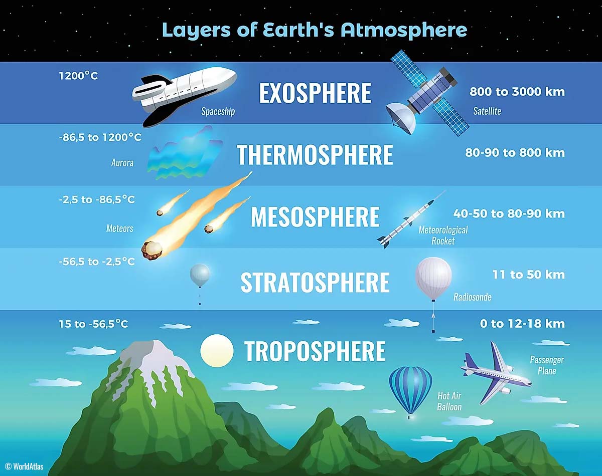
Above this layer is a much deeper one known as the Stratosphere, an 11-50 km thick layer of arid air. Another essential feature in the stratosphere, which makes our weather even more variable, often triggers significant, large-scale, long-lasting winter weather events.
This is the Polar Vortex—an enormous, tri-dimensional ring of powerful winds moving through the sky above us. The Polar Vortex is spinning around the North Pole, grazing through the air at about 20-50 km above the Earth’s surface with violent wind speeds.
How and when does the Polar Vortex form?
Due to the Earth’s inclination, the polar regions receive much less energy from the Sun during the fall months. This makes the cooling over the northern areas more robust. As a result, polar nights can last several consecutive months, followed by days without sunlight.
While temperatures in the polar regions are dropping into a deep freeze, the atmospheric layers farther to the south are still relatively warm because they receive more of the Sun’s energy at the same time. Therefore, the south’s equatorial layers remain much warmer than the areas farther north, leading to a high-temperature contrast.
Cooling the polar regions also lowers the ambient surface pressure, and a similar weather process occurs in the stratosphere. The temperature difference between the North Pole and the equatorial areas increases across both layers.
This creates a large, low-pressure cyclonic circulation across the polar stratosphere, which gives it its famous name—the Polar Vortex.
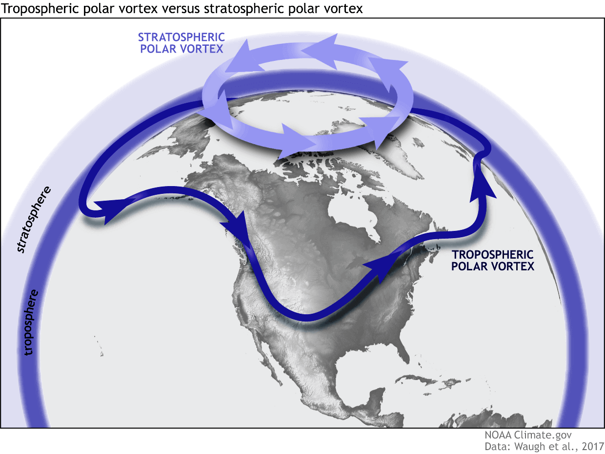
As shown in the image above, we monitor two atmospheric layers during wintertime: the troposphere and the stratosphere. The first is the lowest layer, and the second is at a higher altitude. The Polar Vortex rises through both layers, but with different strengths, shapes, and impacts.
For this reason, we separate the entire Polar Vortex into an upper (stratospheric) and a lower (tropospheric) part. When the Polar Vortex is strong, it traps colder air in the polar regions, preventing its escape and creating milder conditions for most of the United States, Europe, and other mid-latitudes.
But when the Polar Vortex gets disrupted or even entirely collapses, it can’t fully contain the cold air, which can now easily escape from the polar regions into the United States or other mid-latitude regions. Below is an example of how a disrupted Polar Vortex brings cold polar air into the United States and Europe.
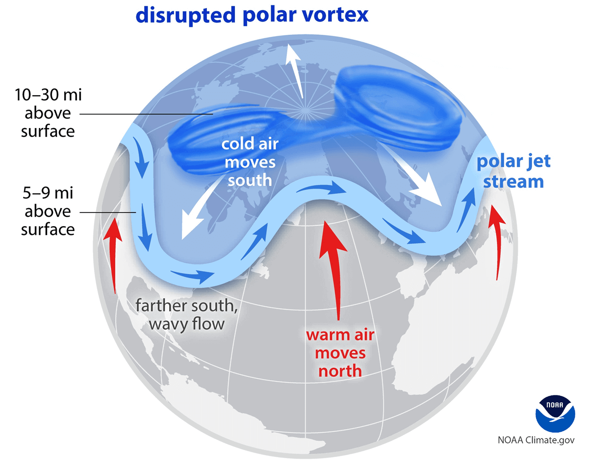
We have experienced this in Asia, Canada, the U.S., and sometimes Europe in recent years. The vortex aloft has been significantly disrupted this season, and when its lobe shifts away from the North Pole, the extreme cold grips the North American continent.
A deep core of the southern Polar Vortex lobe digs into the Southeast U.S. and Florida
As mentioned earlier, a significant disruption and the potential collapse of the Polar Vortex is underway and will follow through early February.
This is sending deep cold Arctic intrusions far south across North America, with one blasting into the Southeast U.S. over the weekend.
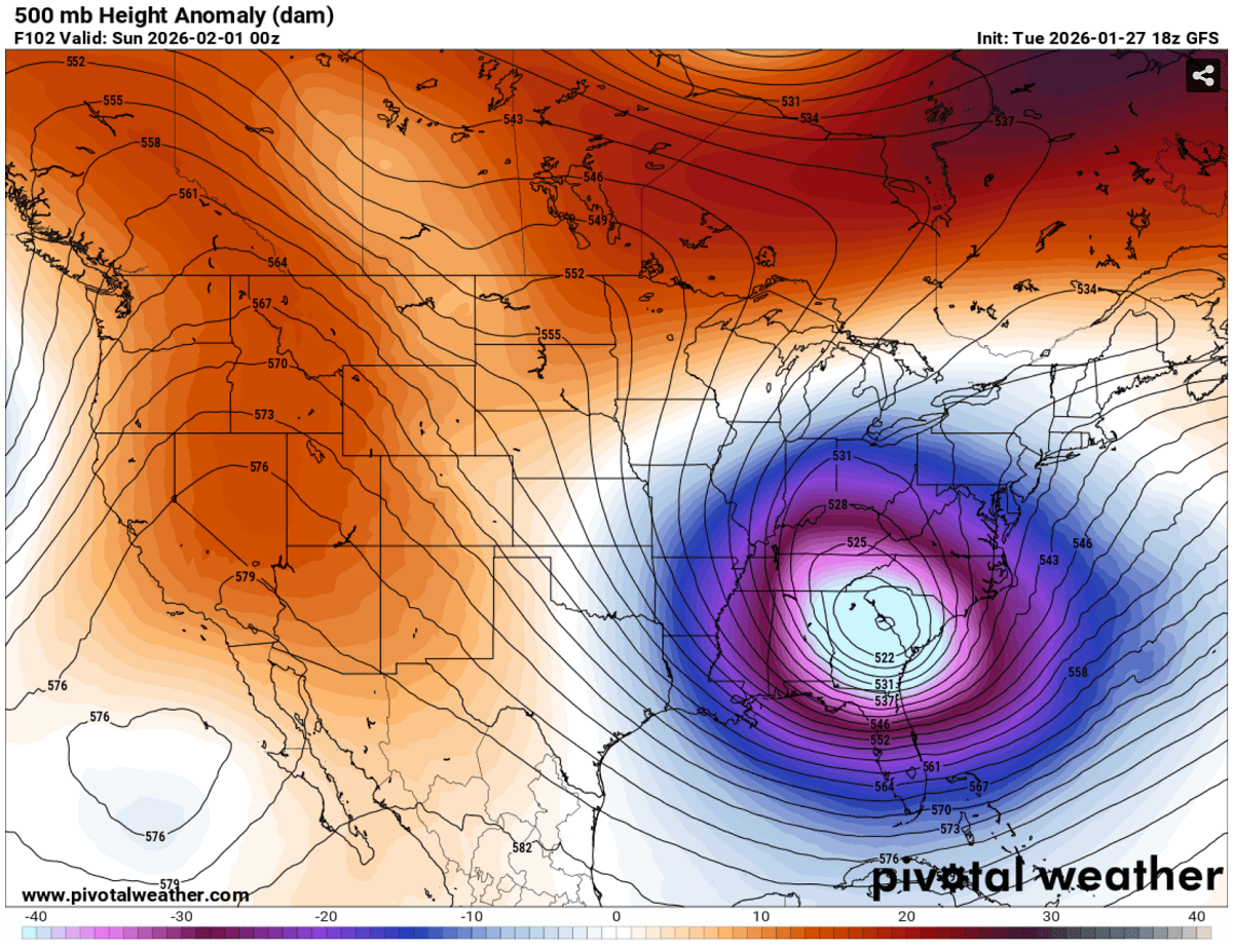
It leads to a major displacement of the polar jet stream, with its winds digging deep south into the Gulf region as the strong blocking High persists over the western CONUS and the North Pacific.
An amplified jet stream follows after the collision with the subtropical air masses, developing violent winds in the upper levels.
It helps drag the Arctic cold air masses far south, spreading across the Southeast and the Gulf Coast by the weekend.
Temperatures will be extremely low for the region, with 30-40 °F below normal from Louisiana and Mississippi to Alabama, Georgia, and Florida.
The core of the cold could challenge some mid-level historic records for the region. This really is unusually deep cold this far south.
And this is where the fun begins. The amplified jet stream, with the clash of Arctic cold and warmer subtropical air masses, leads to an explosive development of the surface low off the Southeast coast. A bombogenesis Nor’Easter storm Gianna occurs, with a rapid pressure drop as the low strengthens along the East Coast.
The cold pool over the eastern two-thirds of the country raises surface pressure, creating a strong pressure gradient with the deepening low over the Atlantic coast.
This will increase the wind field from the East Coast and the Mid-Atlantic states to the Northeast U.S. and to Nova Scotia, Canada. Leading to blowing snow and, in case of new snowfall, also violent blizzard conditions and whiteouts.
Nor’Easter could bring major snow and intense blizzard conditions for the East Coast
Despite some uncertainties about the storm’s track on Saturday, the potential for a highly impactful snow and blizzard is increasing. The general weather model consensus, with ECMWF and GFS, hints at an impact on the Outer Banks, with the GFS solution more aggressive.
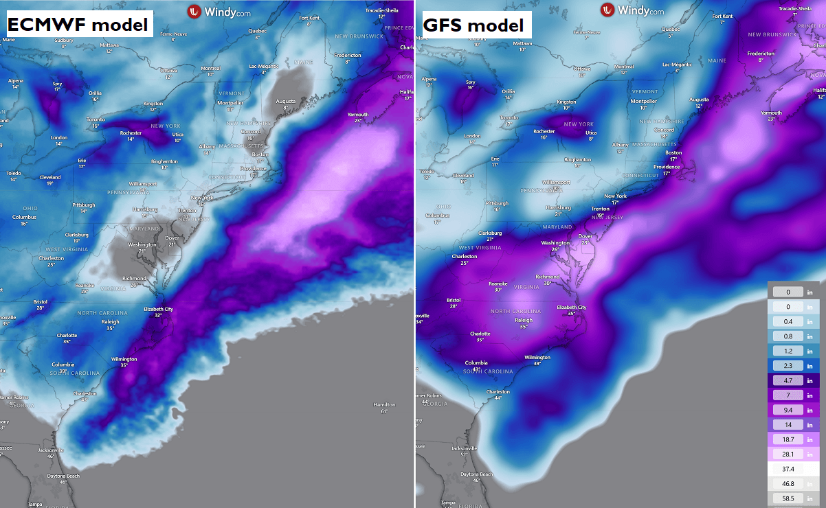
The following snowfall chart from the GFS model hints at where the snowstorm’s worst impact could be. It should be noted that it all depends on how close to the East Coast the core of the bomb cyclone Nor’Easter passes. The further west it goes, the more significant the impact will be.
The chart suggests that North Carolina and Virginia could be in the path of a violent winter storm Gianna. This will likely bring more snow to the areas affected by the recent Winter Storm Fern.
More deep snow is possible over Raleigh, Washington, D.C., including New York City, Rhode Island, and Boston, over the weekend.
What’s concerning is the strength of the near-surface winds, as the pressure and temperature difference between the center low and the Southeast U.S. will be extreme. This should result in particularly severe winds.
Although the exact position of the low is still uncertain, if the low sits closer to the coast, the violent winds will be damaging to trees and infrastructure.
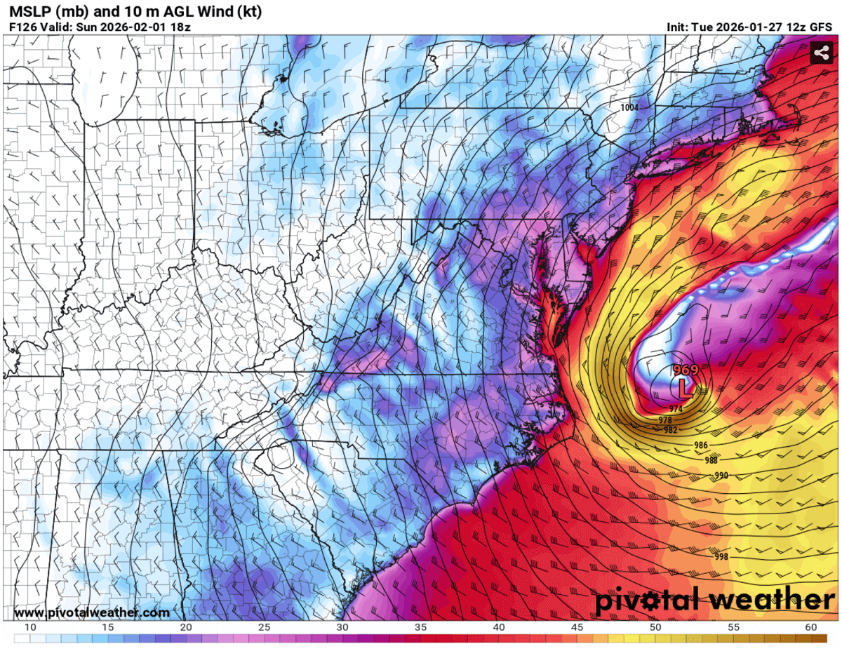
Combined with heavy snow, severe blizzard conditions would result in major travel disruptions, whiteout conditions, high snow drifts, and major delays. Including more flight cancellations.
Unusually deep cold core sends record-challenging temperatures into the Southeast and Florida
The core of the Polar Vortex lobe aloft will be unusually deep, and it will dig very far south across North America, spreading extreme cold across the Southeast U.S., including the Gulf Coast and Florida. Morning lows over the weekend will be frigid for 250+ million people east of the Rockies.
Saturday morning temperatures will be in the single digits across the Midwest, the Great Lakes, the Ohio and Tennessee Valleys, and the Northeast U.S., possibly even in negative degrees F in Indiana and Michigan. In the tens for the rest, low to mid-20s for the High Plains and Texas.
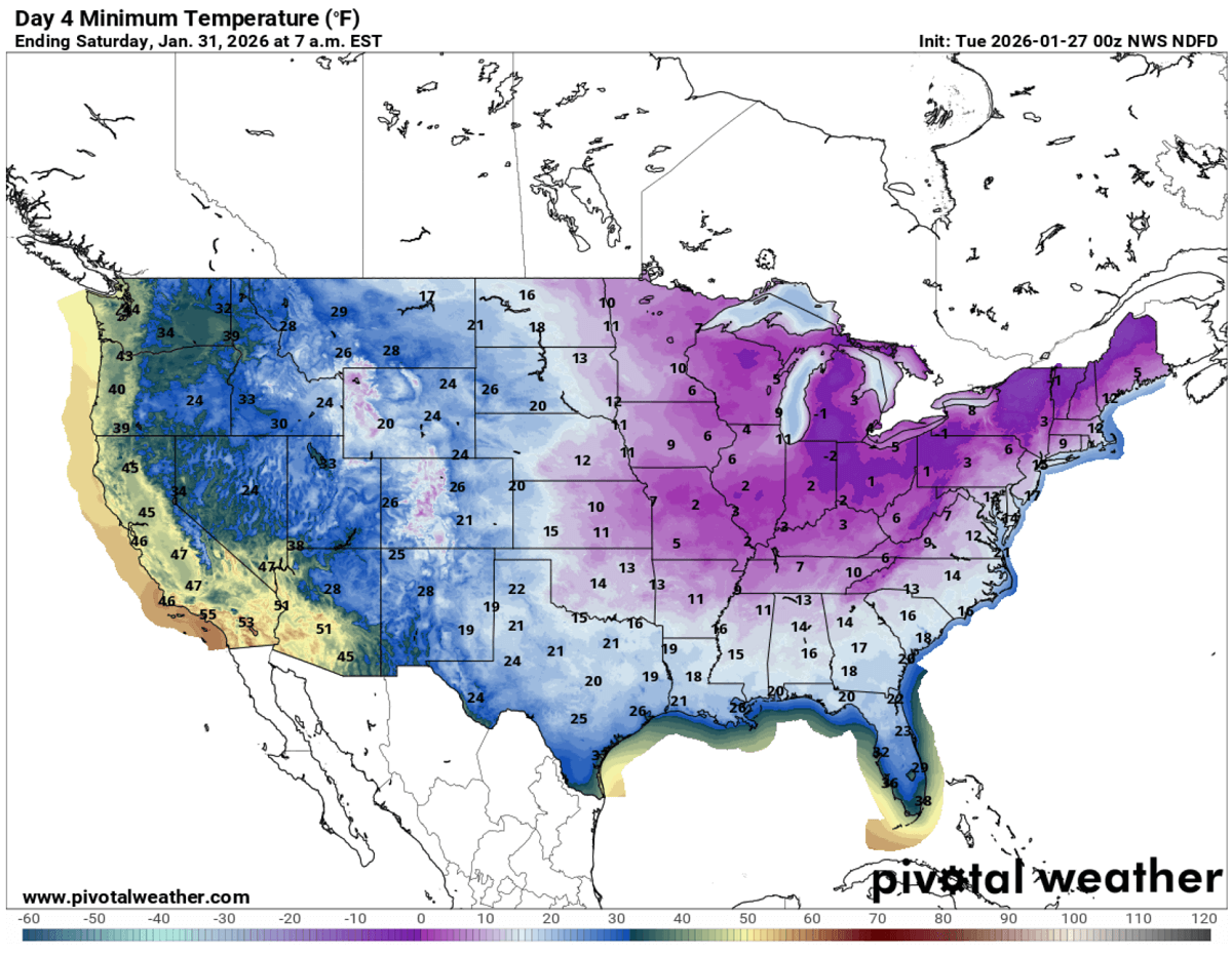
A closer look across the Southeast U.S. suggests the cold will be particularly extreme, also along the Gulf Coast and across all of Florida. Morning lows will reach mid-20s in central Florida.
Further south, freezing temperatures and morning frosts will be possible in extreme southern Florida, including Miami. This is extremely low for the state, and the last time a subfreezing temperature this low occurred in Florida was in December 1989.
Saturday morning, low temperatures could challenge multiple station records across Florida.
To conclude, the upcoming secondary wave of the Arctic cold blast will be quite intense for the Southeast U.S. It will trigger a violent bomb cyclone, acting as a Nor’Easter winter storm Gianna off the East Coast, and could bring intense blizzards and heavy snow with damaging winds to the Outer Banks.
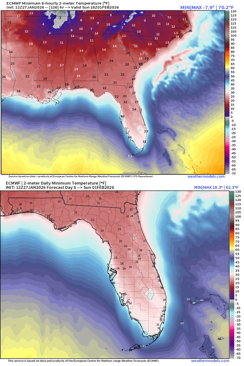
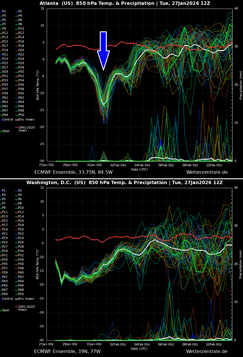
The cold across the Southeast U.S. will be brief but intense. The following chart shows the temperature forecast for Atlanta (upper chart) and Washington, D.C. (lower chart). We can see that both regions are under deep cold for at least another week, while Atlanta hints at a deep core over the weekend.
As we head into February, we will continue monitoring the ongoing progressive and active weather pattern across Canada and the United States. The potential collapse of the Polar Vortex is likely to trigger more frigid cold outbreaks and winter storms with deep snow across North America in the coming weeks.
Stay tuned for further updates.
Windy, PivotalWeather, and Wxcharts provided images used in this article.