The split Polar Vortex is forecast to enter a new recovery phase, helping to create a large shift in the weather patterns across the United States, Canada, and Europe. But the extended range data shows that this is likely a temporary reset period, with January looking to return cold air across parts of the United States and Europe, aided by a stronger Polar Vortex.
A Polar Vortex disruption usually brings a colder weather change to the mid-latitudes. But a strengthening (along with other global factors) can also bring a significant change in daily weather.
First, we will quickly look at how the Polar Vortex affected the winter weather patterns so far this season. Then, we will focus on the upcoming Polar Vortex recovery phase, the weather pattern changes expected this month, and the early weather trends for January 2026 across the United States, Canada, and Europe.
THE COLD POLAR VORTEX
The Polar Vortex always gets a lot of attention once we enter winter, and it can seem like a complex system to understand. But in reality, the Polar Vortex is just a name that describes the broad winter circulation over the northern (and southern) hemispheres.
The Polar Vortex extends high up into the atmosphere. The lowest level of the atmosphere is called the troposphere, where all the weather events occur. But above that, we have the stratosphere, which is a deeper and drier layer.
For this reason, we separate the entire Polar Vortex into an upper (stratospheric) and a lower (tropospheric) part. They both play their role differently, so we monitor how both parts work together.
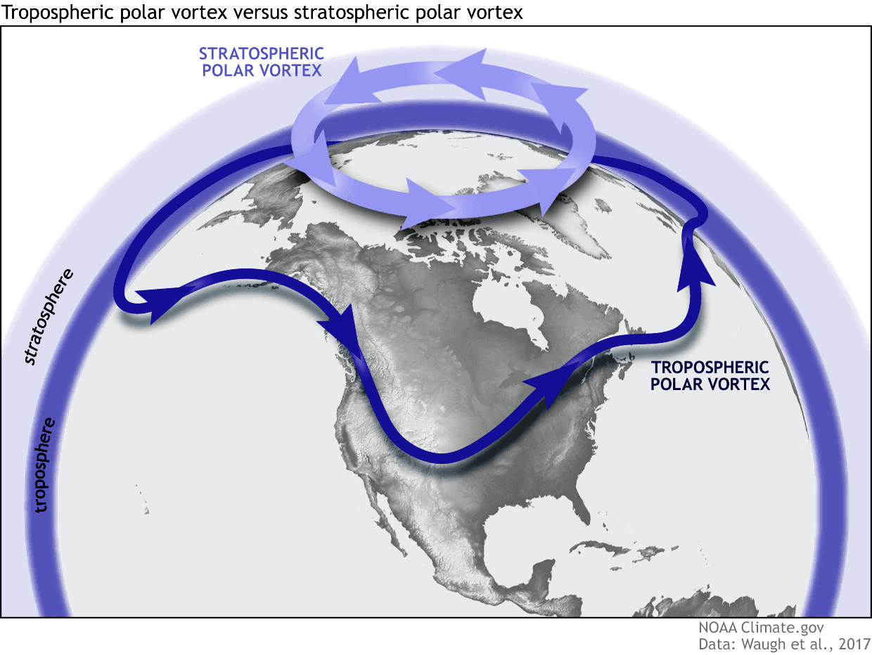
Together, the two parts shape winter circulation across the Northern Hemisphere and the resulting weather patterns over the United States, Canada, and Europe.
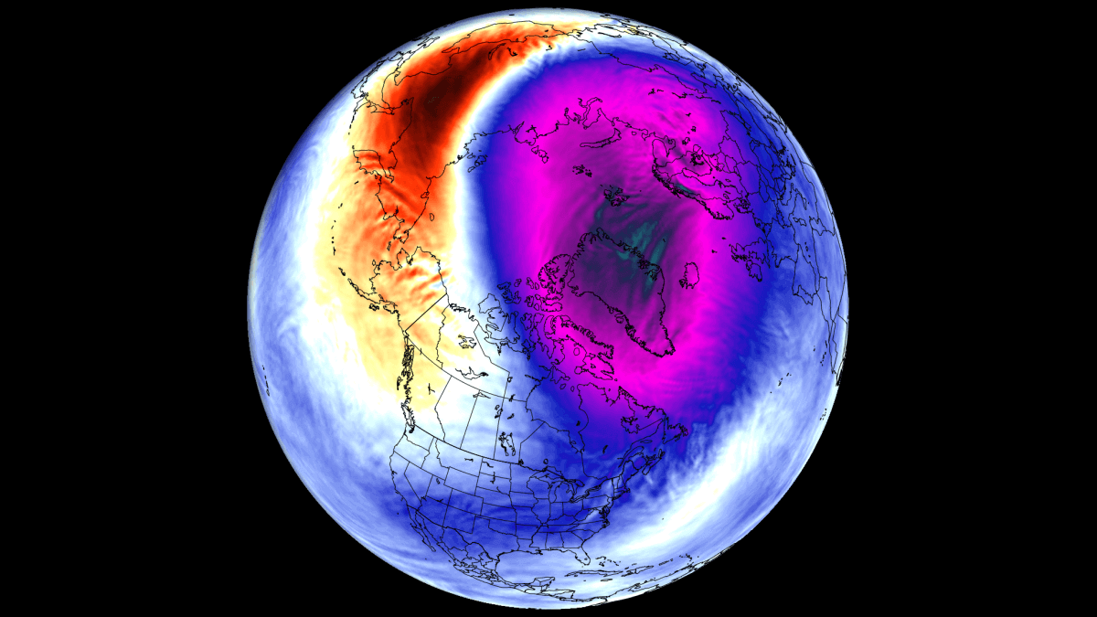
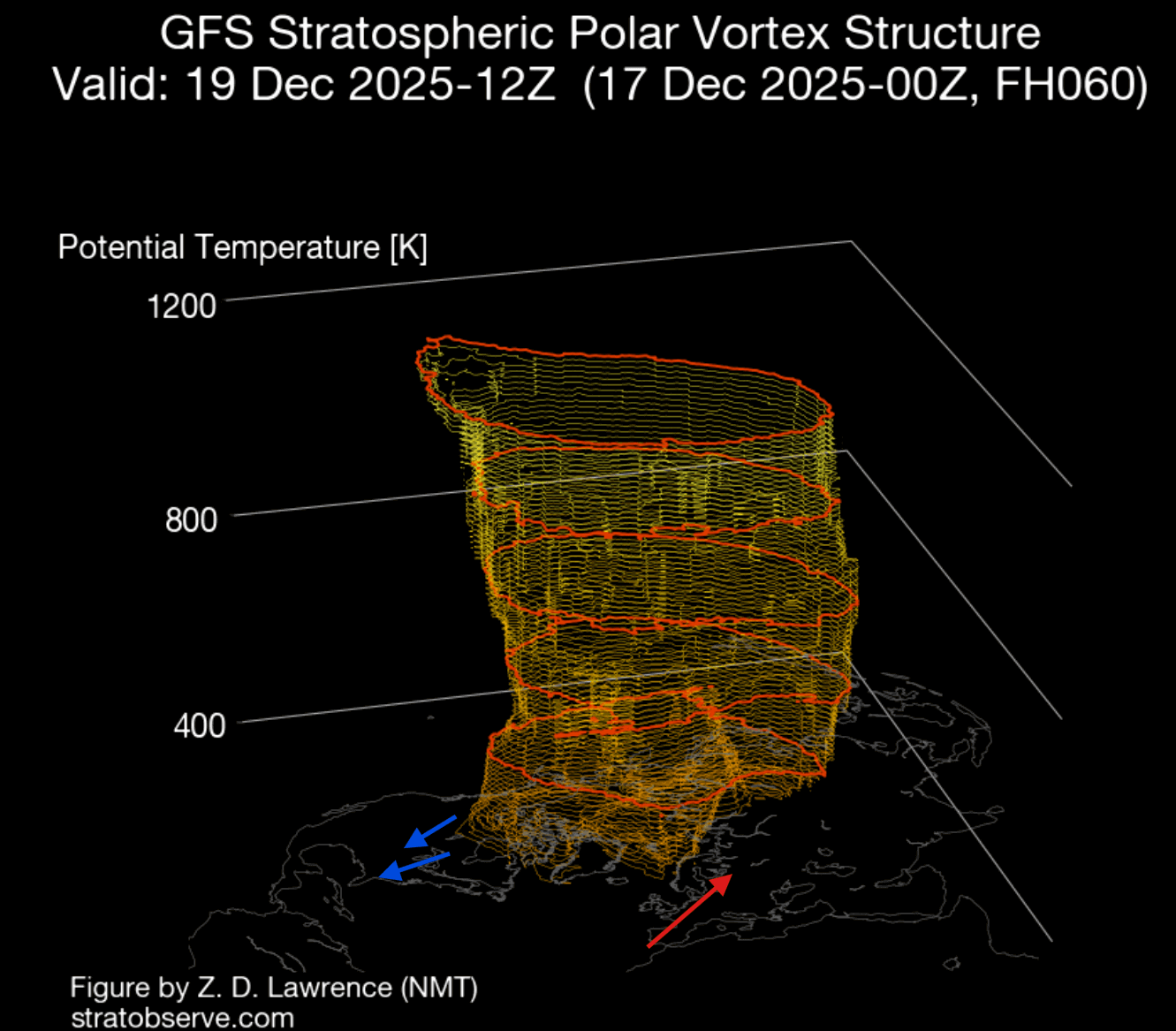
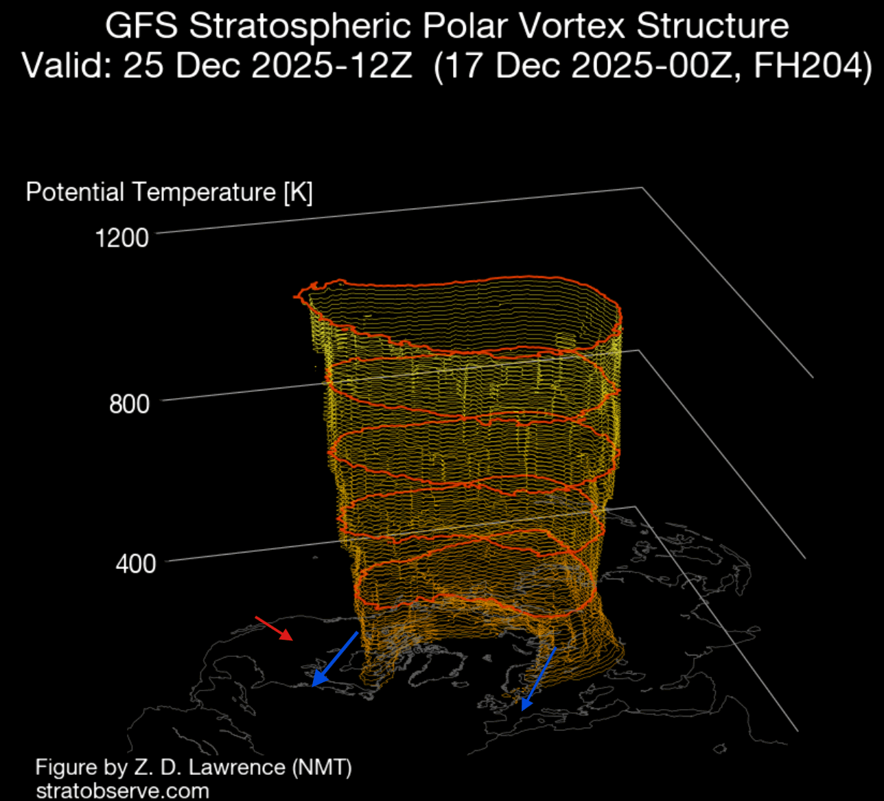
Below, you can see a 3-dimensional image of the Polar Vortex from earlier this month. You can nicely see one core of the Polar Vortex connecting to North America. This has had regional impacts across the United States and Canada, driving multiple cold-air waves in December so far.
To display the Polar Vortex even better, we produced a high-resolution video below that shows it in 3D, giving you a better idea of what it actually looks like. This video shows the stratospheric warming around the Polar Vortex, which helped to create this colder outcome over the United States and Canada.
A stratospheric warming (SSW) event is a rapid rise of pressure and temperature in the stratosphere. It has currently calmed down, but its effects are visible in the weather patterns.
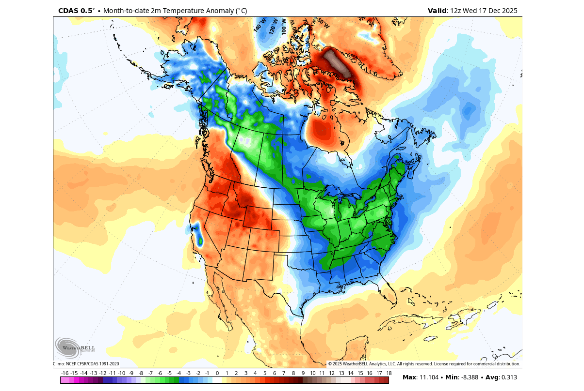
You can see the temperature analysis for the month so far (1st-17th), which shows the clear cold corridor from western Canada into the northern, central, and eastern United States and southeastern Canada. This was driven by the Polar Vortex core sitting over Canada.
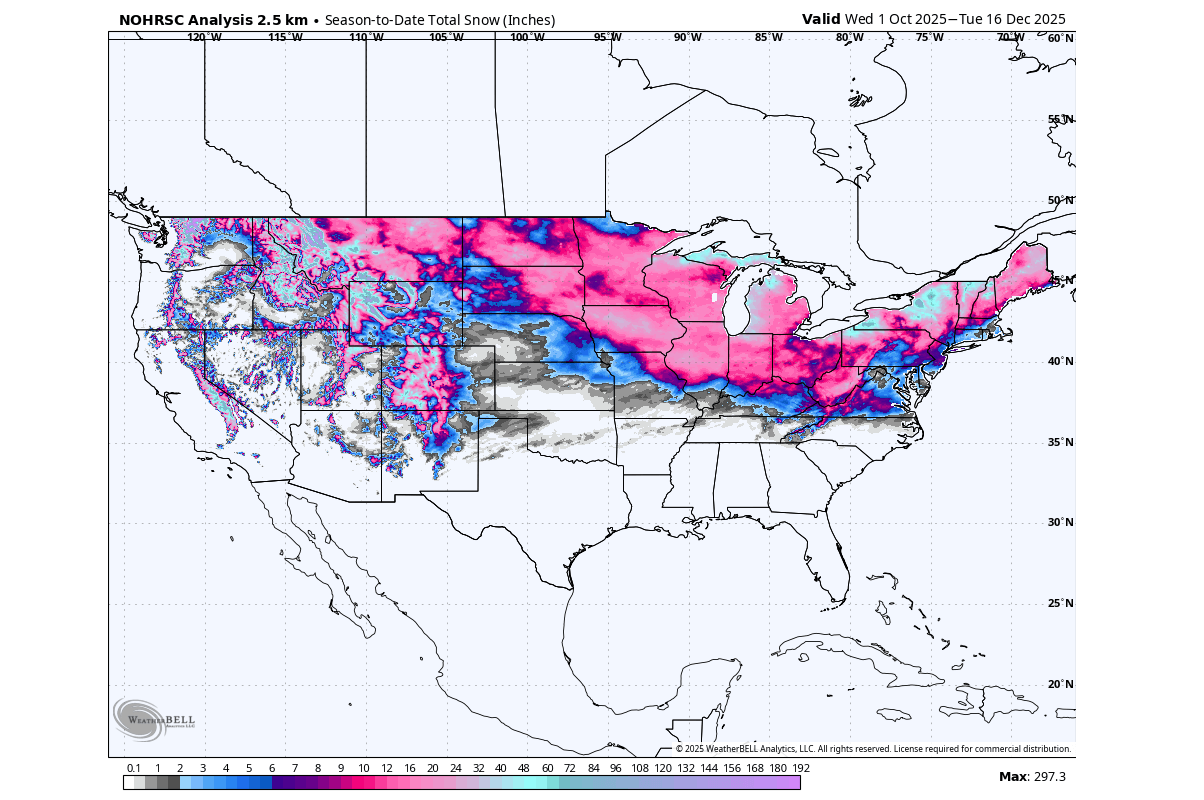
This has enabled the total snowfall to cover a decent area in December so far (not snow on the ground), which can be seen below in the NOHRSC snowfall data analysis for the season so far. Snowfall has occurred all the way from the elevation in the west, to the northern and central Plains, to the Midwest and the northeastern United States.
This pattern is currently still ongoing, but with changes coming to the Polar Vortex, the forecasts also show a mild period to take over the United States, while cold weather will arrive in Europe.
A STRATOSPHERIC VORTEX CORE
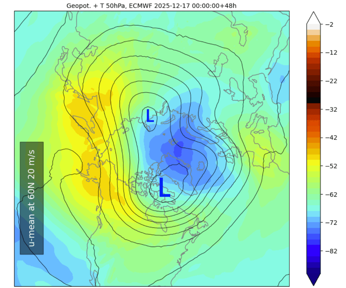
Below is the pressure/temperature forecast for the lower stratosphere at the 50mb level (20km/12.4miles). In this image, you can see the two low-pressure “inner vortices” of a split Polar Vortex. You can see a larger core positioned over North America, impacting the regional weather over the United States and Canada. Image by weatheriscool.com
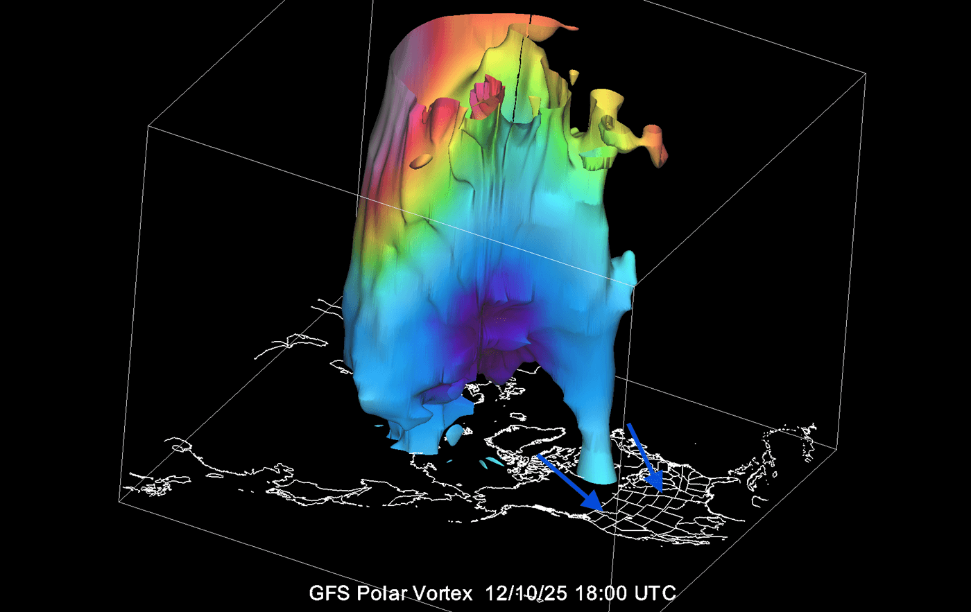
As the Polar Vortex splits, the remaining cores transport cold air toward the mid-latitudes as they move further south out of the Polar regions.
We can see this on the 3D Polar Vortex analysis below. With the upper structure still deformed, the main lower stratospheric core is sitting over North America. Because the core spins counterclockwise, it brings northerly flow into southern Canada and the United States and warmer flow into Europe.
The image below shows the lower stratosphere at the 50mb level (20km/12.4miles), with the inner core of the Polar Vortex split into two areas. This is caused by the strong high-pressure systems from below, pushing into the Polar Vortex, just like squeezing a balloon.
You can see the main low-pressure area at this altitude, and how its counterclockwise spin drives a colder northerly flow into southern Canada and the United States. At the same time, you can see the warmer air being transported into Europe.
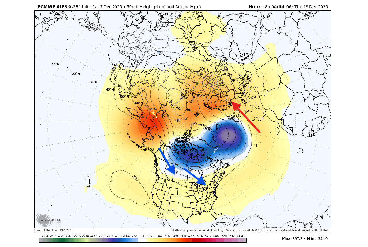
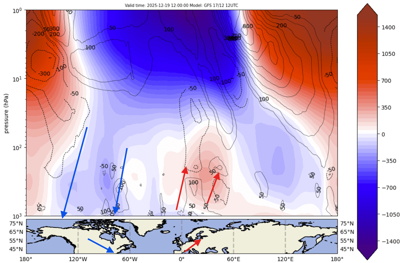
The atmospheric forecast image below shows the pressure anomaly from the surface to the top of the stratosphere. You can clearly see how the lower Polar Vortex is split in half, with one core connecting down into the United States and Canada. At the same time, a high-pressure anomaly is building over Europe, with milder weather.
The surface temperature forecast for the next few days shows another spill of colder air from southern Canada into the Midwest and the eastern United States. At the same time, a ridge is starting to build in the west, pushing in a milder, warmer airmass for the Christmas week ahead.
At this point, we have to look at the Polar Vortex strength and its changes/movements, as it will play a role in the weather development further into Winter.
But how do we measure the strength of the stratospheric Polar Vortex? The usual way is with the winds. The stronger the stratospheric Polar Vortex is, the stronger the winds it produces around its core. This can translate to a stronger influence on the surface.
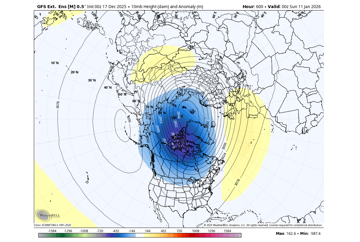
Below is the latest analysis and forecast of the stratospheric winds around the Polar Vortex at the 10mb level (30km/18.5miles height). You can see the wind speed reduction in mid-month, during the split core. But you can also clearly see a strength recovery, lasting into the new year.
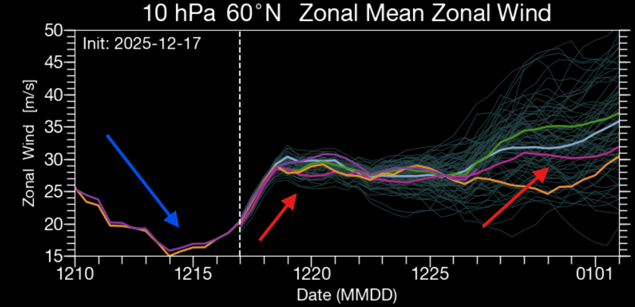
This will also mark the start of a milder period across the Continental United States, except in the Northeast, as you will see further down. A weather change is also expected over Europe.
THE WINDS OF CHANGE
Coincidentally, the pattern changes are expected to start in the Christmas week. This will, of course, impact the snowfall potential over the holiday season.
The stratospheric forecast at the 50 mb level (20km/12.4 miles) for next week shows continued core separation, but the stronger core is starting to pull back. You can see that it has an extension out to the Pacific, signaling a more westerly/mild pattern developing over the United States.
At the same time, the northeastern United States still has some cold potential in this setup. You can also see the strong high-pressure anomaly developing over Greenland (Greenland blocking), which will help to create a more northerly and easterly flow into Europe.
You can also see this on the 3D Polar Vortex forecast below. The North American low-level core is pulling back towards the polar regions as the Polar Vortex starts to strengthen, with another leg pulled into Europe. Between these two Polar Vortex “legs” you can see the empty space, which is the Greenland blocking (high-pressure).
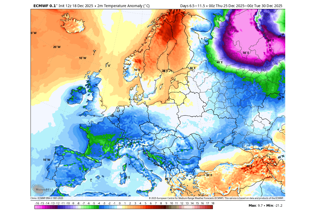
Looking at Europe first, below you can see the most recent temperature forecast for the last week of December. The Greenland blocking enables a more northeasterly flow, bringing down the colder airmass for most of the continent.
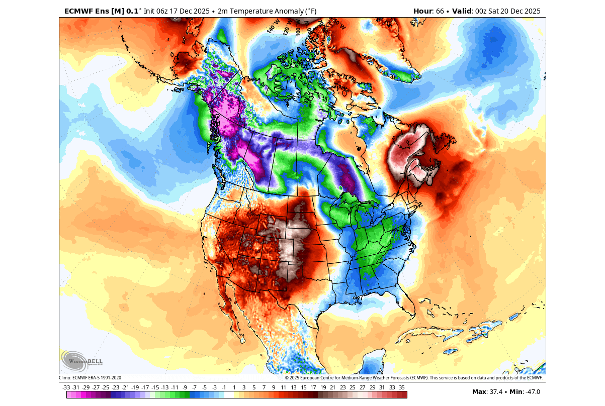
The ensemble temperature forecast for the same period over North America shows a warm airmass spreading across the United States. An area of colder air and northerly flow will remain over the northeastern United States. This is the result of the Polar Vortex core moving and the Greenland blocking being positioned farther east.
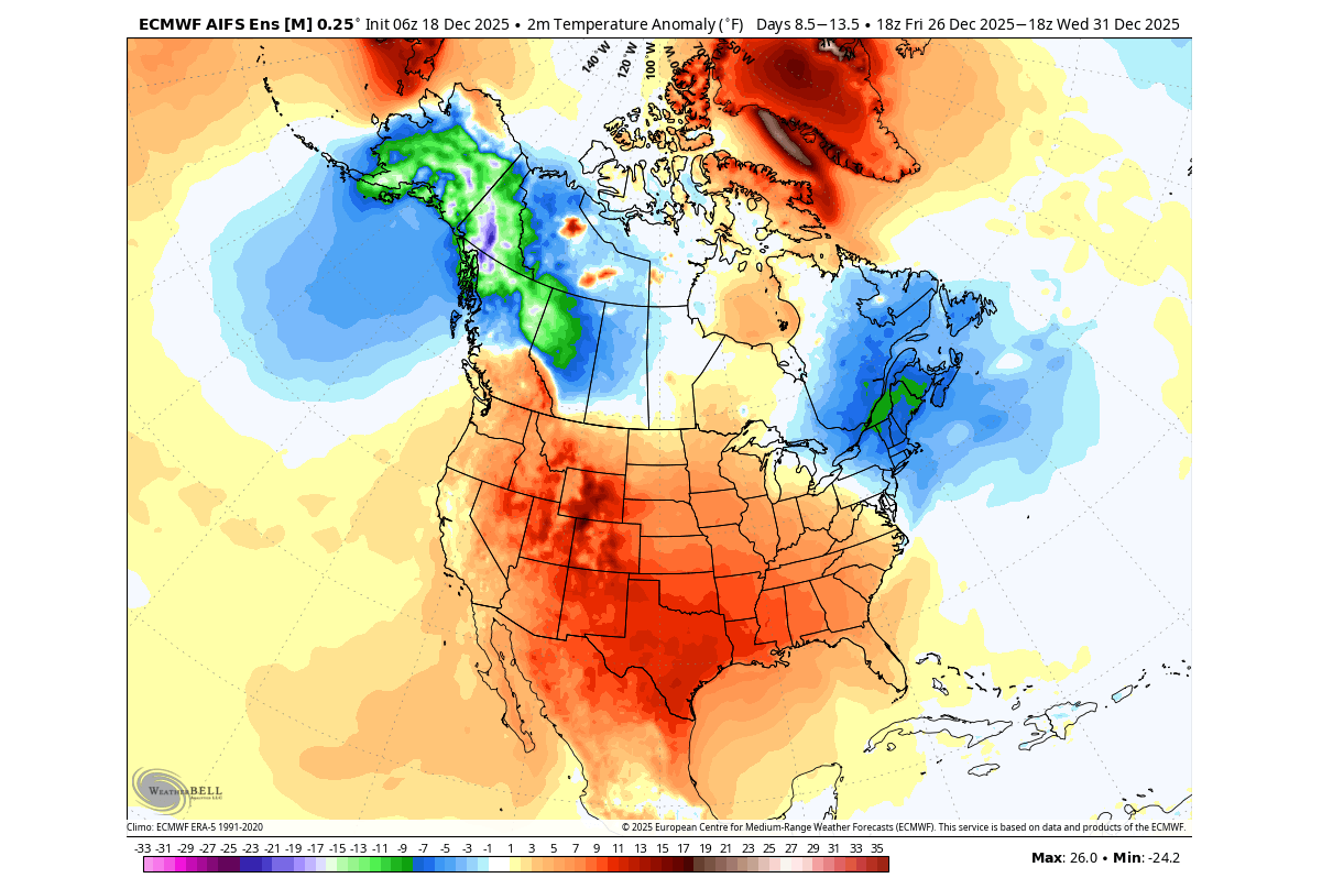
We can note that while these are above-normal temperatures, the mean temperature in late December is already low. So while these colors look “hot”, you don’t expect summer temperatures in the Midwest, for example.
CHRISTMAS WEATHER AND SNOW
The Polar Vortex core movement and the high-pressure systems building all have a direct impact on the Christmas weather and snow potential.
Looking at the temperature forecast for the 25th, you can see a large warm anomaly, as the westerly winds bring in a mild airmass. As the Polar Vortex core moves back toward the polar regions, the main cold air supply remains over southwestern and southeastern Canada and the northeastern United States.
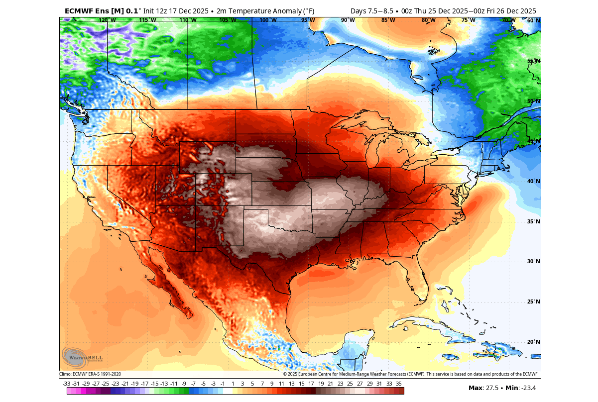
This is a special holiday anomaly, which has a playful nickname, “merry torchmas”, among the weather community.
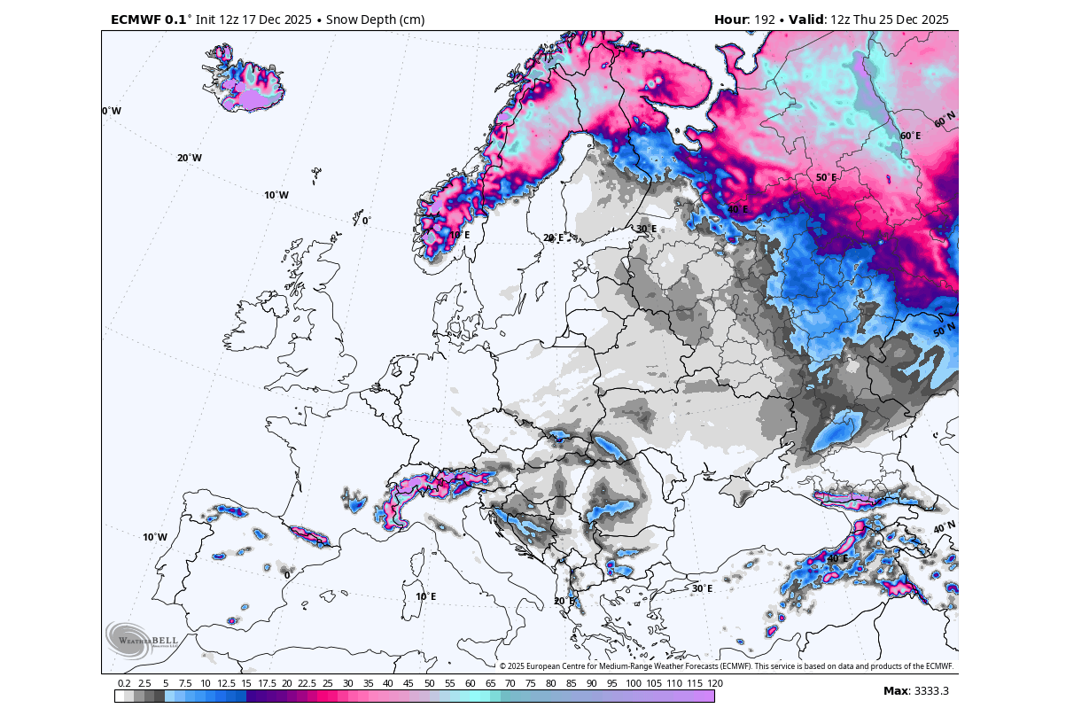
The snow depth forecast on Christmas morning shows the deepest snow on the ground in southern Canada and the elevations of the Rockies. Snow on the ground is also forecast over the northern Plains, into the upper Midwest and the northern Great Lakes, and over the northeastern United States.

Across Europe, the latest forecast models show cold air arriving on Christmas Day, driven by a strong high-pressure system blocking over Greenland and the Polar Vortex leg in the region. These are not strong cold anomalies, but it is a break in the current warmer weather.

The morning snow depth forecast shows the main snow potential over the northern parts, where temperatures are low enough, and over the elevations. There is some snow depth indicated towards central Europe, thanks to the cold air wave coming down in that sme route.
But as we now know, the Polar Vortex and pressure patterns are ever-changing, so we always look at the extended range forecast to spot early developing trends.
NEW YEAR, STRONGER POLAR VORTEX
Below is the latest pressure analysis and forecast from the surface up to the top of the stratosphere. You can see the stratospheric warming event in late November and the eventual progress towards the lower levels, which impacted the weather patterns in December. Image by Hebridean Weather
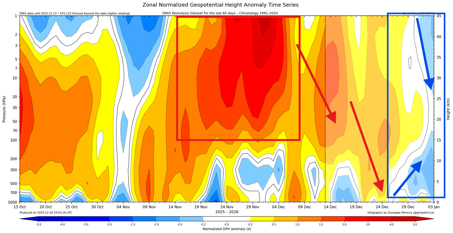
You can also see the change after Christmas, as the Polar Vortex tries to strengthen up, both in the stratosphere and the lower levels, causing a pressure drop. We have to monitor where the potential connection will be between these two systems, as the stratospheric Polar Vortex can amplify the lower cores.
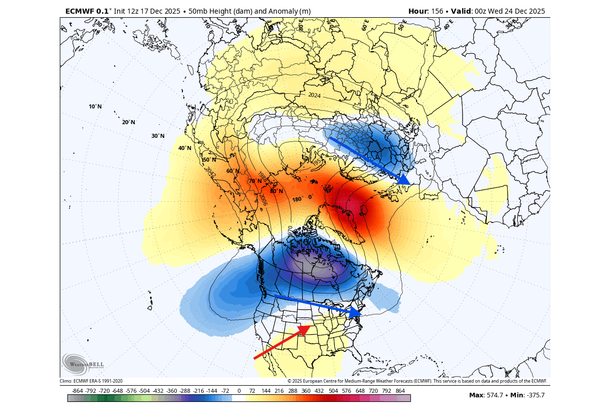
We can look at the mid-stratospheric pressure anomaly forecast in the second week of January. You can see the Polar Vortex and how it’s running stronger than normal, with a colder core and lower pressure. The main question is where its lower counterpart will land, and if it will connect to the stratosphere for a boost.
Looking at the lower layers, the pressure anomaly forecast shows a potential cold signal around the second week of January. What you can see in the forecast below is the main lower Polar Vortex core positioned over Canada. This can drive the northerly flow back into southern Canada and the United States.
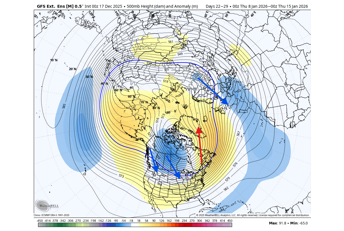
At the same time, it helps to sustain a high-pressure anomaly over Greenland, which downstream enables a colder airmass to spread into Europe. It’s a real rollercoaster of pressure systems, also known as the Rossby waves.
So the aim here is to find the connection between the stronger Polar Vortex in the stratosphere and how it will connect down to amplify/change the daily weather. For example, a low-pressure area over Canada can be strengthened by the strong Polar Vortex in the stratosphere, but only under certain conditions, so monitoring is key.
The temperature forecast trend for the second week of January shows the cold air anomaly building back over western and southern Canada, and extending into the northern United States and into the central Plains.
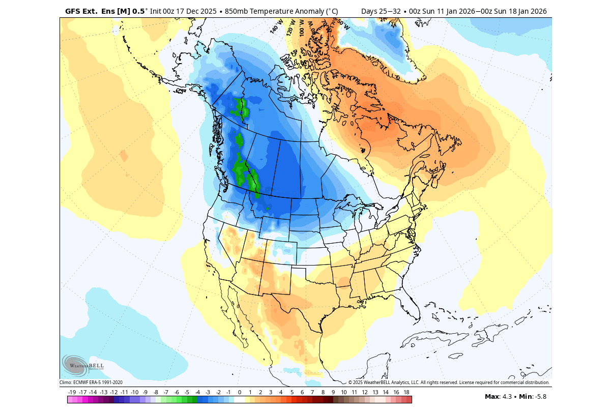
Of course, at this range, we are only concerned with the placement of temperature anomalies and how each new calculation updates the forecast. But so far, the forecast data suggests a return of the cold pattern is likely in the first half of January over the United States and southern Canada.
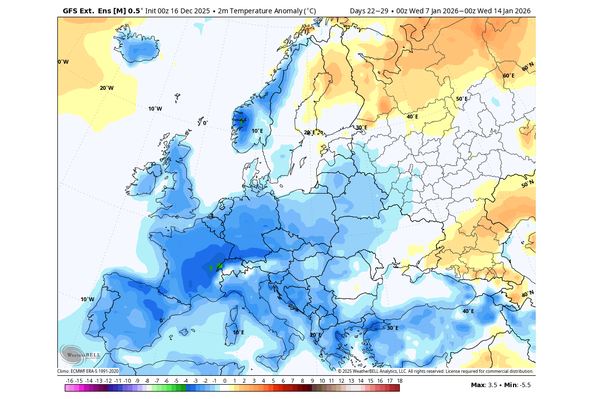
Europe, on the other hand, won’t be that dependent on the Polar Vortex itself, as it aims to benefit from the strong high-pressure anomaly over Greenland. That enables a northerly flow, maintaining the potential for colder temperatures across the first half of January.
We will keep you updated on the global weather pattern development, so don’t forget to bookmark our page. Also, if you have seen this article in the Google App (Discover) feed, click the like button (♥) there to see more of our forecasts and our latest articles on weather and nature in general.
The main forecast images in this article are from WeatherBell, using a commercial forecaster license.
Don’t miss:
El Niño Watch: Latest Forecasts Show El Niño Returning in 2026