The North Atlantic does not take breaks in this year’s first autumn month. The progressive weather pattern continues through mid-September 2025, bringing multiple intense storms and frontal systems to western Europe. On Sunday, a fierce surface cyclone blasts into Ireland with gale-force winds and spreads high waves and squalls into the southwest UK and Wales.
A new deep wave is racing and strengthening over the North Atlantic. It is forecast to rapidly intensify the surface low Saturday night into Sunday, meaning intense winds and significant wave heights will push towards Ireland, Northern Ireland, and the southwest UK over the next 36 hours.
Met Éireann has issued weather warnings for strong and gusty westerly winds on Sunday into early Monday, which could result in difficult travelling conditions, debris, and loose objects displaced throughout the country.
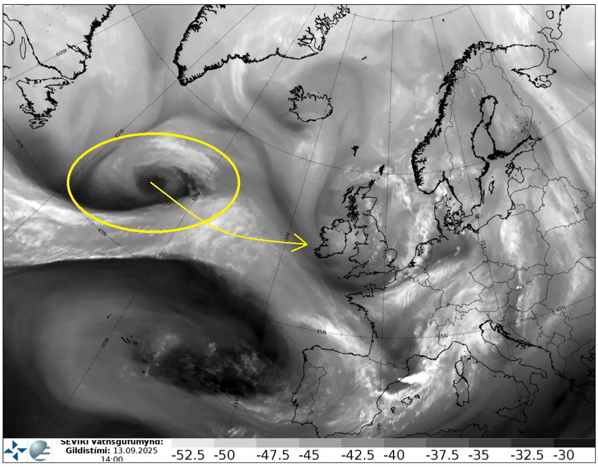
On Saturday, water vapor satellite image analysis over the North Atlantic and Europe revealed a frontal wave moving over western and central Europe, while a rapid frontogenesis was taking place further west over the Atlantic, between Newfoundland and Ireland.
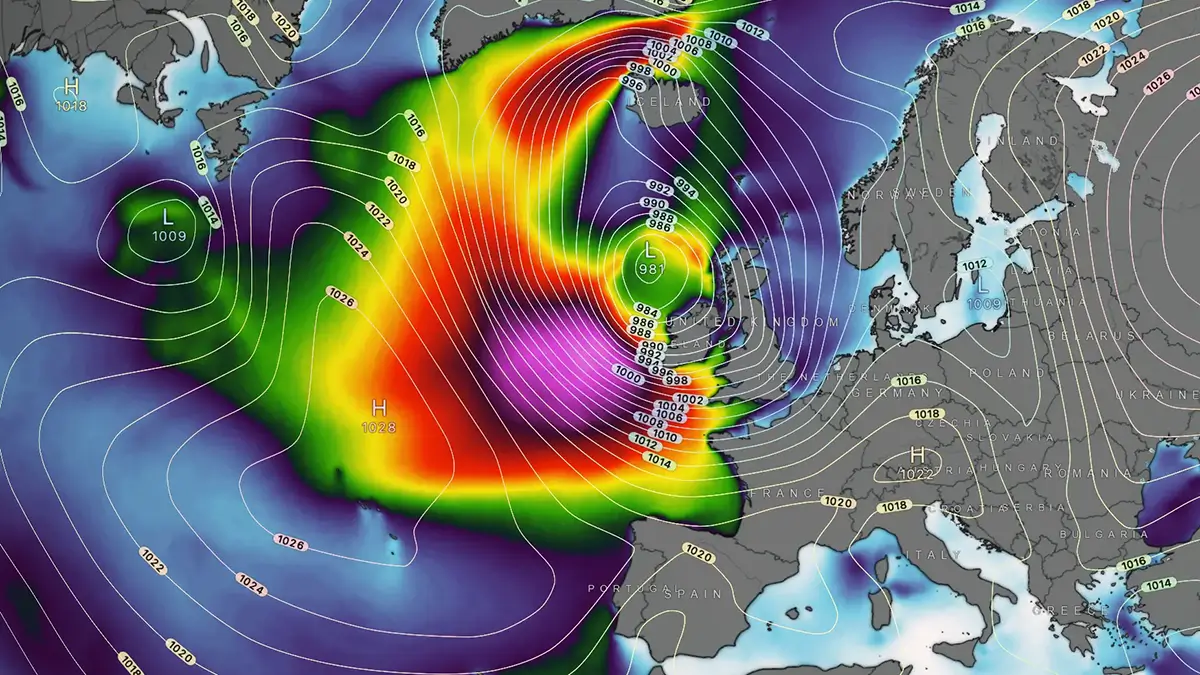
While this was still far from European land, the weather model simulations hint at a potentially impactful Atlantic storm over the next 36 hours. The surface low is forecast to push the central pressure into the upper 970s mbar.
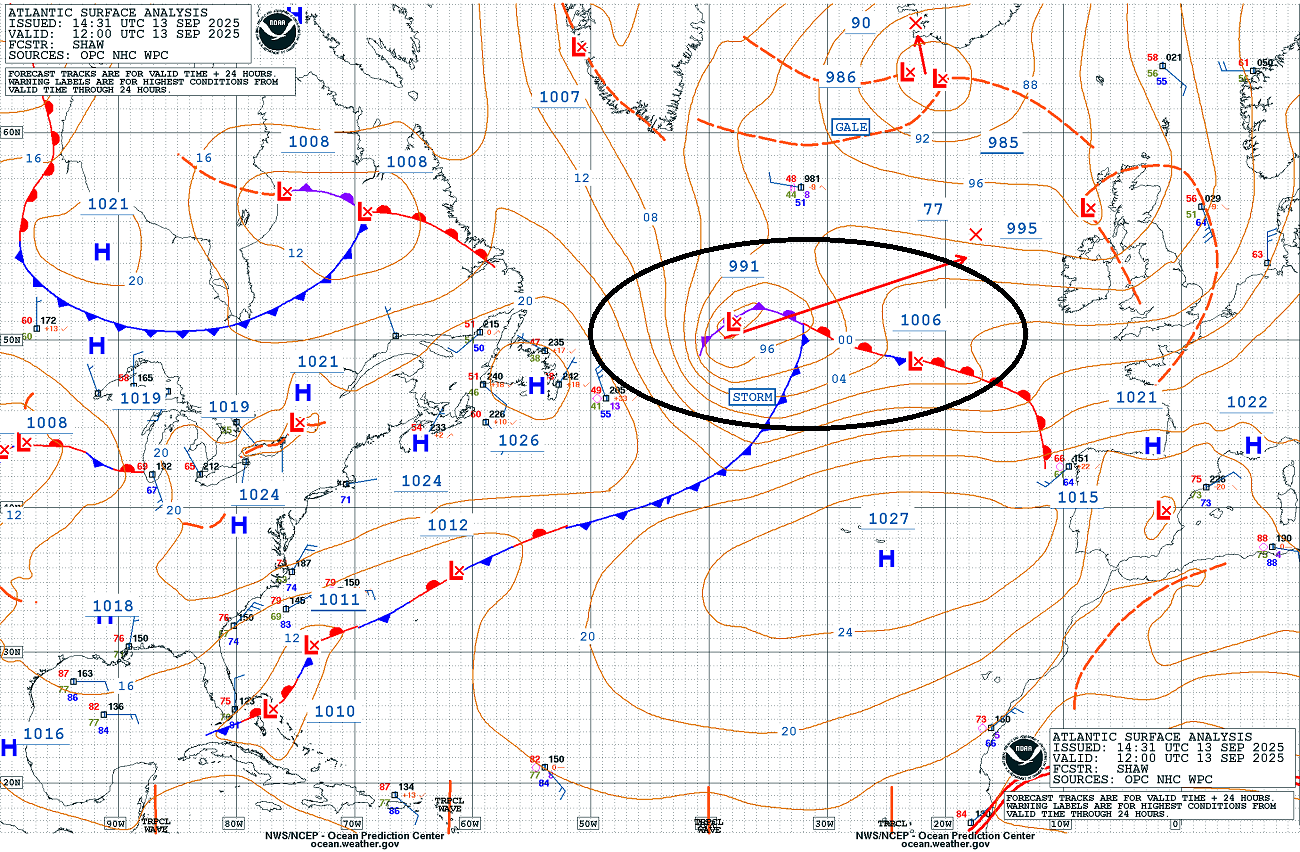
NOAA’s 12 UTC ocean surface analysis over the North Atlantic reveals an already well-organized storm traveling towards Western Europe.
The most likely scenario involves bringing this low towards Ireland and Northern Ireland on Sunday. The system will peak west of the land, with its most impactful part to the south-southeast of the center low.
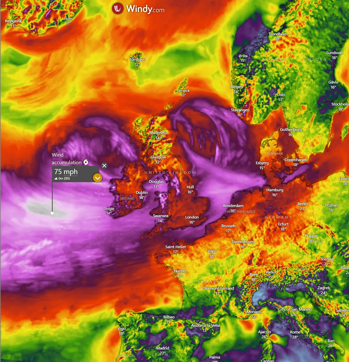
The system’s rapid intensification of the surface center low leads to an intense wind field, supporting gale-force winds for Ireland, Northern Ireland, Wales, and the southwestern UK from Sunday morning through Monday morning.
As we enter the autumn season in Europe, the potential for intense Atlantic storms to develop is higher. These storms can bring severe windstorms and significant wave heights, dramatically impacting life and property across Western Europe.
Aside note:
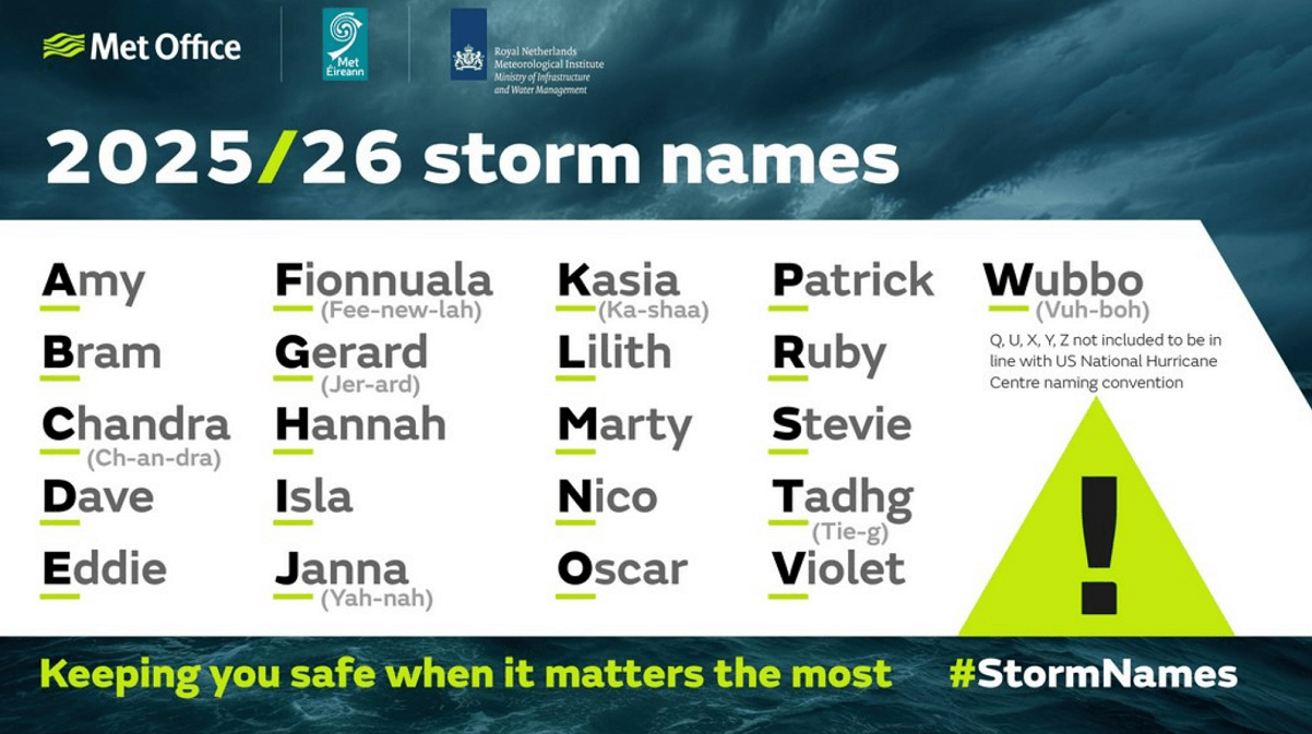
The Irish meteorological agency, Met Éireann, in partnership with the National Meteorological Services of the UK (Met Office) and the Netherlands (KNMI), has launched the new list of cyclone names for the 2025/26 storm season.
The Atlantic storm season that affects Europe runs from September 1st, 2025, until August 31st, 2026. Of the list of 21 names, each national partner has contributed seven storm names publicly voted on in the summer months.
A storm is named when it could result in medium or high impacts in any one of the three meteorological partner countries. Naming storms allows for authoritative and consistent communications with the public, enabling them to prepare for and stay safe during potentially severe weather impacts.
Naming storms is a powerful tool that supports meteorological agencies and other public safety organisations in increasing awareness of severe and impactful weather alongside regular weather warnings. Naming storms makes it easier for people to track essential and up-to-date forecast and safety-related information.
Let’s dig into details regarding the evolution of the intense Atlantic low coming up this Sunday into the following Monday for Ireland and the UK. If the upcoming windstorm will support enough intensity for Ireland or the UK, the storm will get its name—the first one on the list is Storm Amy.
Another deep wave emerges from the west and develops into an intense Atlantic storm on Sunday
The general weather pattern developed over Europe indicates that an Azoric High is elongated and extends into the southwestern part of the continent, with a progressive pattern persisting further north. While the decaying trough ejects out of Eastern Europe on Sunday, to the west, additional deeper troughs are developing over the North Atlantic.
Another strong push in the upper levels brings a cold blob from the polar region into the Atlantic this weekend, significantly deepening the upper wave heading straight towards western Europe.
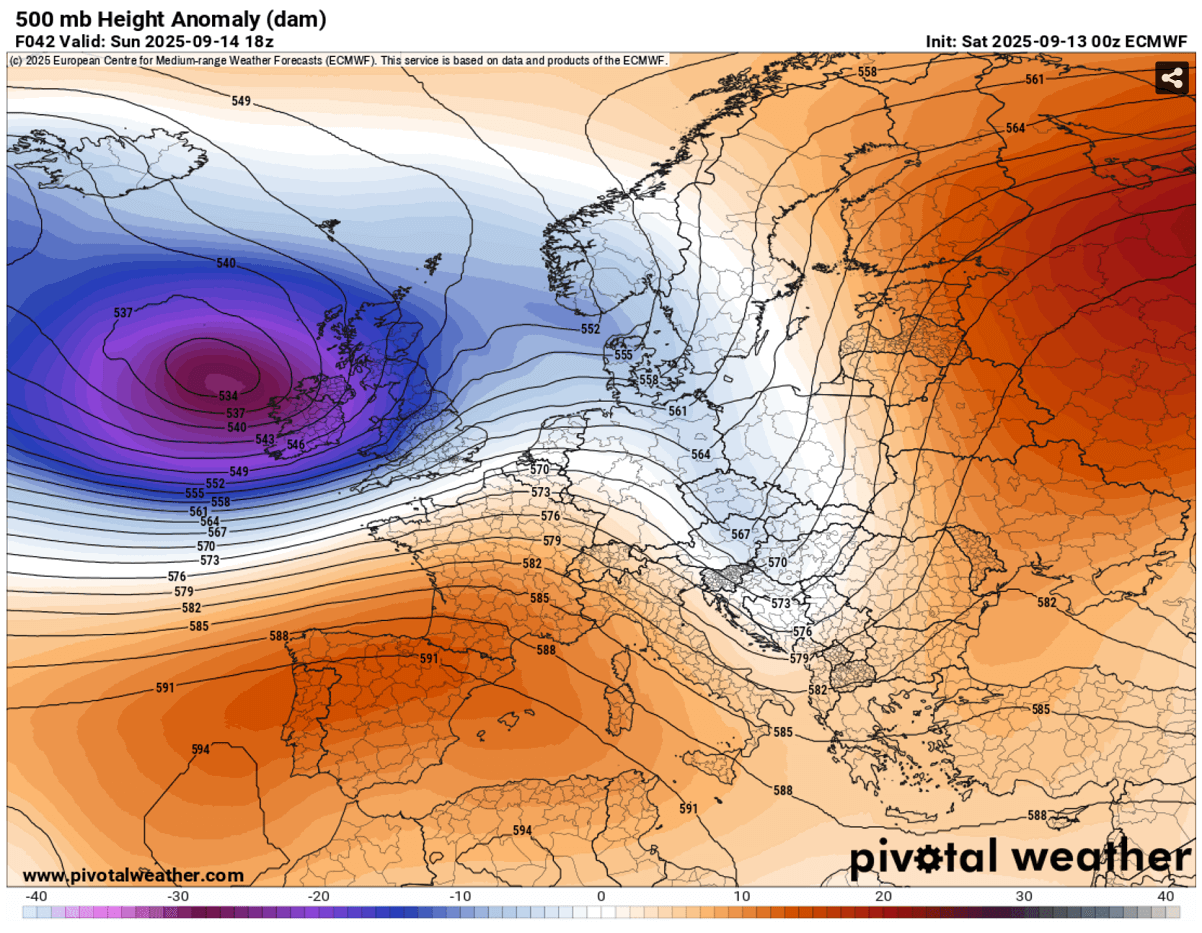
The sharp pressure and temperature gradients between the North and Central Atlantic lead to rapid surface cyclogenesis, intensifying traveling west to east from Saturday night into Sunday night as the new cold intrusion occurs aloft. The Azoric high-pressure system remains strong and elongated into southern Europe, bringing stable days there.
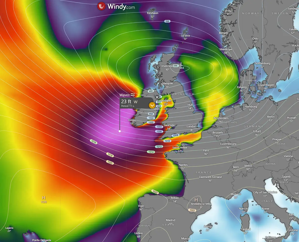
This translates into much deeper surface pressure with the new Atlantic storm, pushing the central pressure to around 980 mbar or even lower, per some high-resolution models. By Sunday afternoon, it was centered west-northwest of Ireland and Northern Ireland.
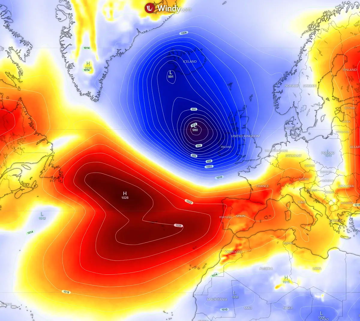
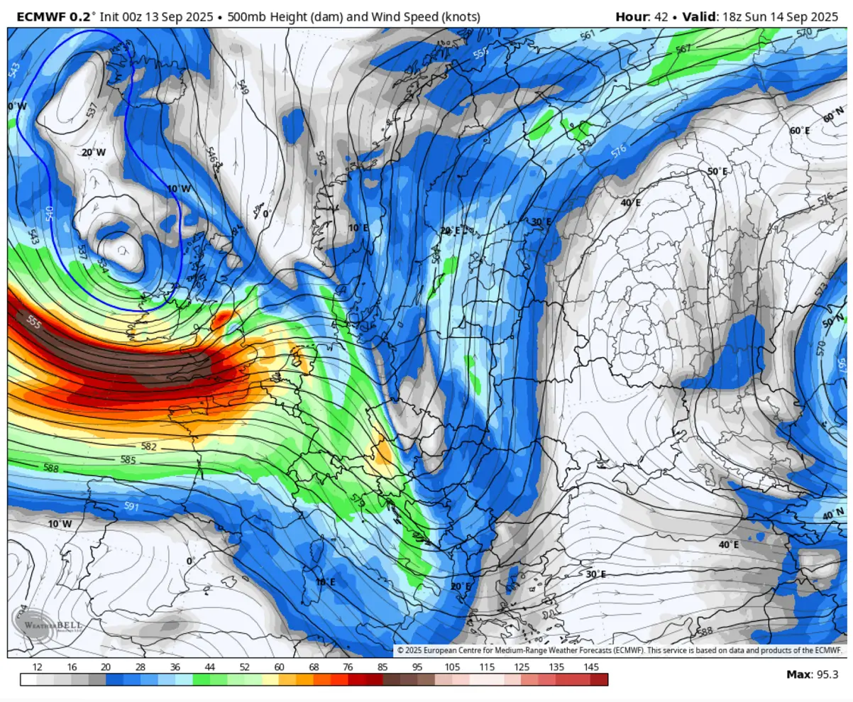
Judging the tight gradient across isohietes and isobars between the Low on the North Atlantic and the High over the Azores, one can assume winds will be powerful in between. The gradient strengthens the jet stream, thus helping the surface frontal system emerge quickly into Ireland and the UK.
Intense upper-level winds develop, with near 100 knots of sustained winds at the 500 mbar level. Thus, those traveling by airplane, despite going faster than usual, they can expect more turbulence on Sunday.
As mentioned, the combination of colder air mass intrusion aloft and a blocking High with warmer air to the south begins the rapid intensification process of the surface low. So, it impacts Ireland, Northern Ireland, and the Outer Hebrides in Scotland by early Sunday afternoon and continues into the night.
The following video animation describes the approaching new intense low and its impact on Western Europe from now until Monday.
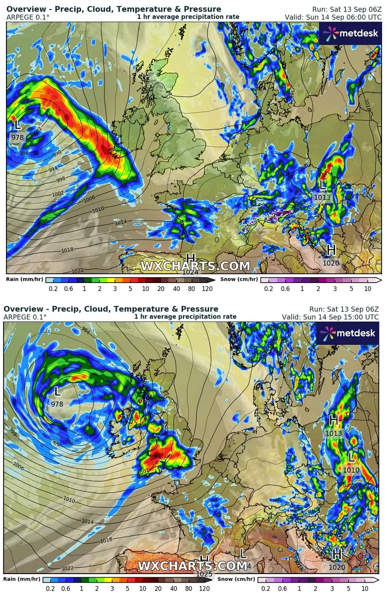
The low’s approach on Sunday morning brings the front to the western Irish coast, with rain squalls spreading east across Ireland, Northern Ireland, and the UK throughout the day.
More gusty squalls for Ireland and the UK as the intense Atlantic storm emerges
The most robust stormy squalls’ impact will likely be across southern Ireland towards Wales and the southwest UK in the afternoon hours. At this time, the low’s central pressure should peak around 978 mbar, located northwest of Ireland.
It intensifies the wind field and waves, gradually spreading towards the coast from Sunday morning, across the UK into the afternoon, and continues to the North Sea through Monday morning.
The general wind impact should bring Ireland, Wales, and the southern UK into the worst part of the storm. High-resolution models suggest winds could be severe locally, gusting 70-80 mph. The most intense winds will develop where the strongest pressure difference is located, and those may impact southwest Ireland with gale-force winds.
The rapid development of the Atlantic storm typically brings significant wave heights as well. At the peak of the storm’s intensity on Sunday afternoon, those waves will reach 25-30 ft (7-8 metres) high and gradually move east towards Ireland.
High waves will also impact the coasts of Wales and southwest Ireland on Sunday night.
Due to the rapid development of the intense core and fast travel across western Europe, the storm’s worst impact will potentially be gale-force winds. Rain squalls should support heavy rain and strong to severe winds when the core nears or goes ashore early Sunday.
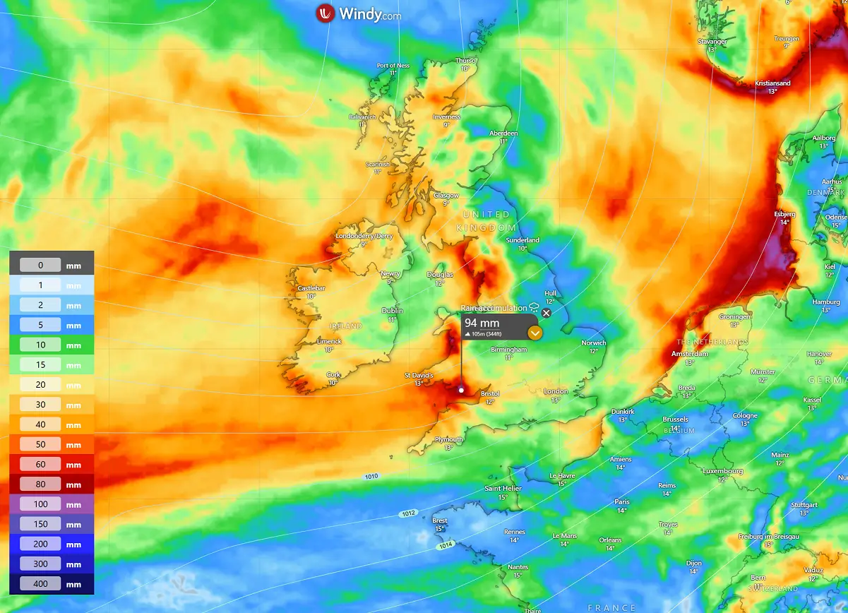
From Sunday morning through Monday afternoon, the 36-hour rainfall sums across Ireland, Northern Ireland, Wales, and part of the western UK could reach around 90 mm, where the local topography will most define the orographic precipitation effects.
The impact of this new Atlantic storm could be significant on coastal areas; stay alert.
Following your local meteorological office/agency for the latest updates and potential warning messages is advised.
Windy, Wxcharts, and WeatherBell provided images used in this article.
See also: