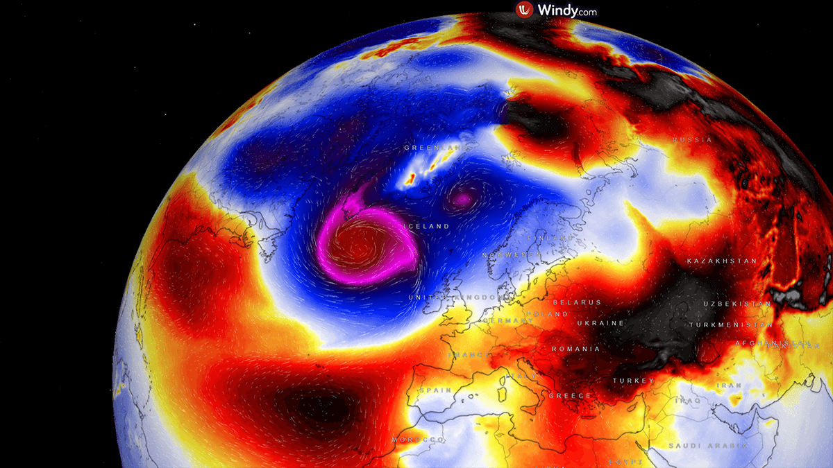
The disruption of the Polar Vortex that resulted in its split across the Northern Hemisphere, sending frigid cold Arctic outbreaks from Canada into the North Atlantic. Triggering violent mid-latitude cyclone, emerging off the eastern North America and traveling towards Europe. A violent 930 mbar low is near Newfoundland and continues to develop explosively on Tuesday.
We are live-tracking an explosive bombogenesis ongoing near Newfoundland, with an extreme central pressure falling through Tuesday morning. The pressure drops are so rapid that they double the criteria for a bomb cyclone.
This cyclone will become the most intense North Atlantic storm so far this season.
Extreme intensification of the wind field and rapid central pressure drop follow the intrusion of the frigid cold air mass from the Northeast U.S. and Eastern Canada.
Monday evening, the intrusion of the polar air mass into the Northwest Atlantic triggered the rapid intensification of the developing low, which is now trailing northeast along Atlantic Canada.
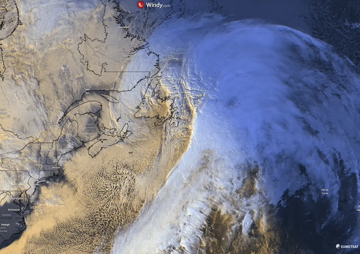
The final visible satellite scans before nightfall revealed an impressive yet textbook cyclonic structure of a rapidly deepening low. The central pressure has been falling by more than 5 mbar per hour, as observed at weather stations across Newfoundland.
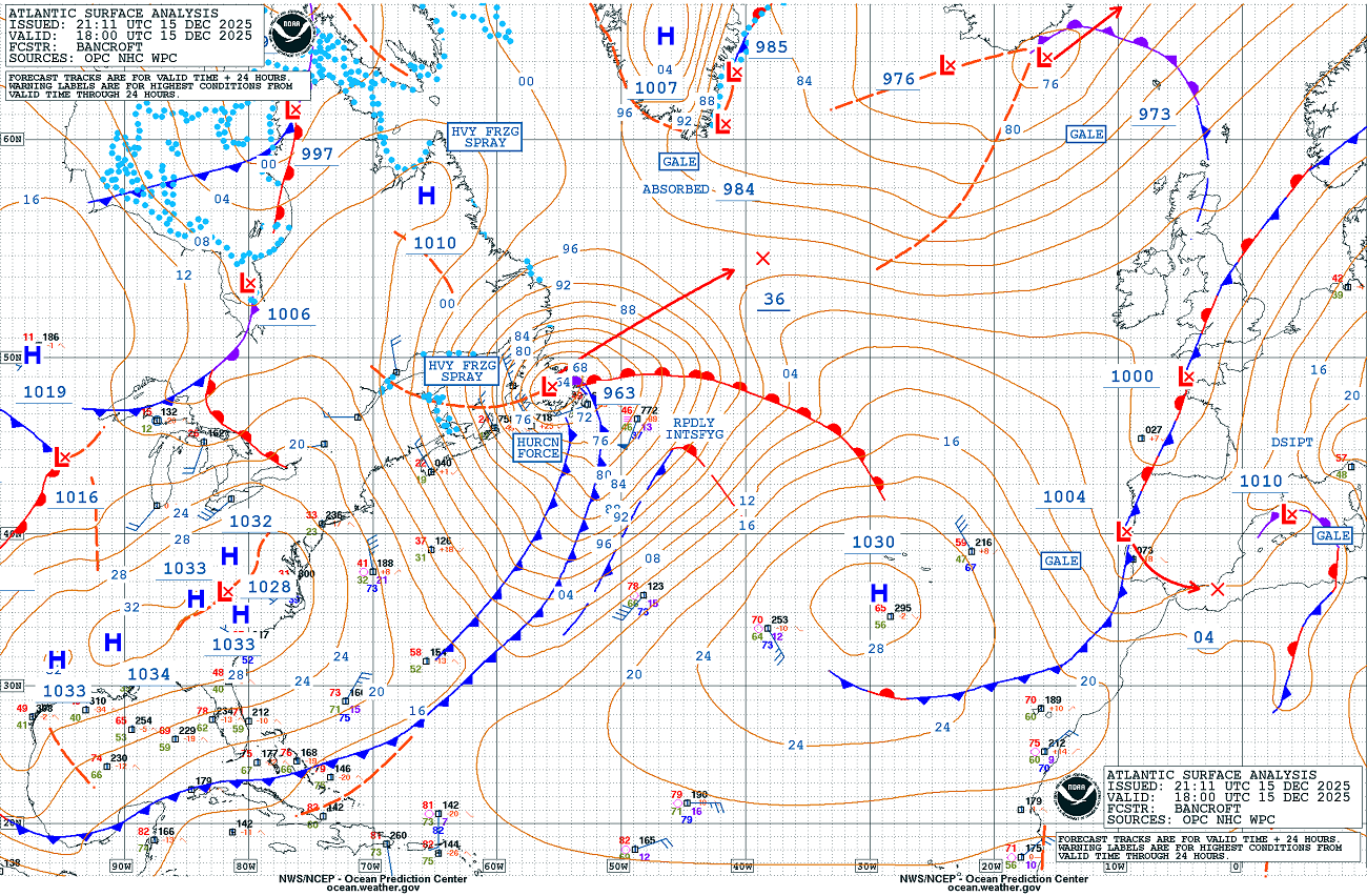
The 18 UTC surface analysis, produced by the NOAA Ocean Prediction Center (OPC), indicated a central pressure of 963 mbar, undergoing rapid intensification, while its center was ejecting over Newfoundland.
The chart also suggests that the central pressure will drop to near 936 mbar by Tuesday evening, another 27 mbar. In other words, the explosive bombogenesis* will continue for another 24 hours.
* Note: The bombogenesis term is used when the extremely rapid development of a mid-latitude cyclone takes place, where the central pressure falls by more than 24 mbar within 24 hours. Such a low is then characterized as a bomb cyclone.
Monday night into early Tuesday, the infrared satellite channel indicated that the pressure had already dropped to near 950 mbar, continuing rapid intensification. The polar air mass is spreading behind the low into the Northwest Atlantic.
Violent winds and local blizzard conditions are spread across Newfoundland.
Here is the satellite video animation of the system developing along the Northeast U.S. on Monday, moving towards Newfoundland while rapidly intensifying.
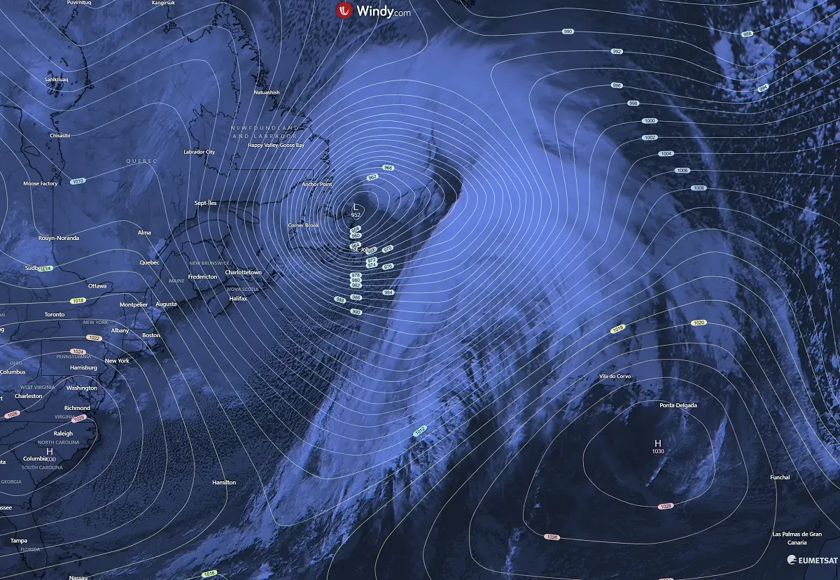
The various satellite channels indicate how well-organized this system will become. Extreme, violent hurricane-force winds are developing in the rear side of the core and could also trigger the sting jet wind maximum on Tuesday.
Let’s dig into further details about this cyclone, the most intense North Atlantic storm so far this season.
Intense upper core emerges into the North Atlantic
Early Tuesday, the Polar Vortex’s southern lobe delivers an intense and cold core from Eastern Canada into the North Atlantic, establishing conditions for further intensification of the deep low that was ejected off the Newfoundland coast.
Further south and east, blocking Highs are located over the Azores and over the European continent, forming an Omega blocking pattern. Providing stable and unseasonably warm weather in the mid-levels. Lowlands, however, are trapped under a strong thermal inversion across many European countries.
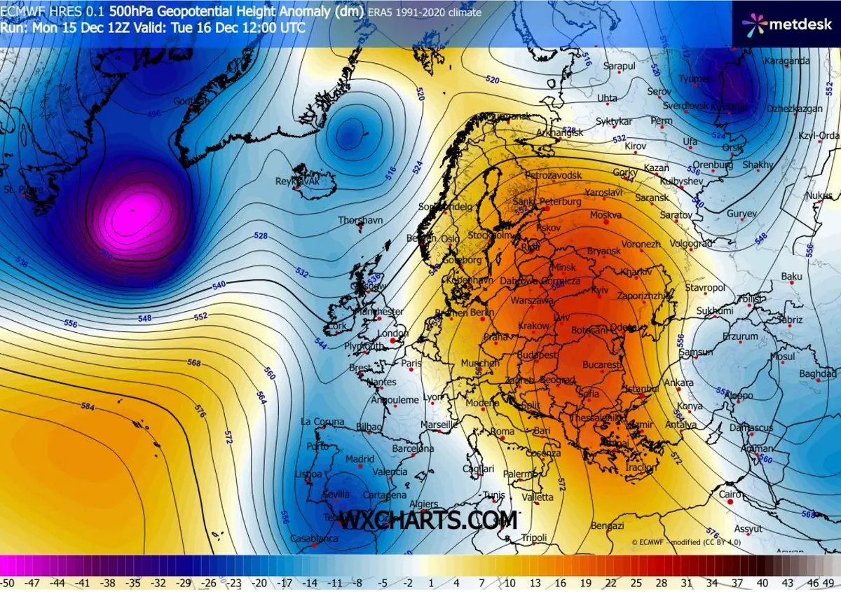
The cold upper core helps deliver even colder air masses over the warmer Atlantic, thereby further deepening its central pressure and intensifying its wind field. Hurricane-force winds will develop.
By evening, the low reaches its peak intensity, likely bottoming out near 930 mbar, located south of Greenland. The low also becomes very large, with broad, violent winds.
The bomb cyclone continues to maintain this strength through Wednesday as it moves farther east, near Europe. Still, it remains a few hundred kilometers west before it begins to rise in pressure and weaken the wind field.

The following peak wind gusts swath chart indicates how large and intense the wind field will develop with the low. Violent, hurricane-force winds will be spread across a large part of the North Atlantic.
As the low weakens considerably late Wednesday into the night, these winds will mostly remain west of Europe over the open Atlantic. Hence, a significant impact on Western Europe is unlikely and not expected.
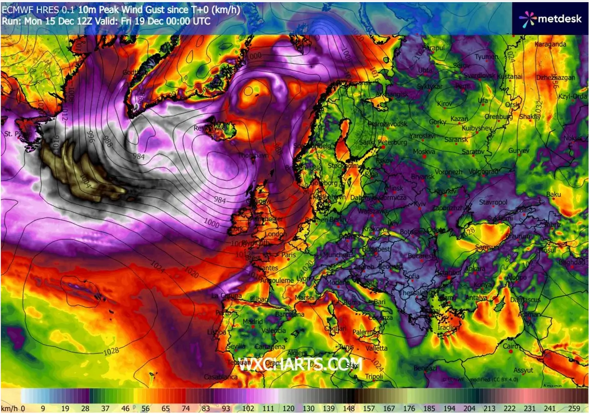
Over Europe, the wind field structure suggests low winds, indicating a high-pressure system will remain and that all the dynamic weather will be over the North Atlantic. Therefore, the zonal flow weather pattern continues throughout this week.
More heavy rain and windy conditions for Ireland and the UK this week
The core of the upper low will also reach its peak intensity on Wednesday when it will be centered south-southwest of Iceland. Supporting the deep bomb cyclone to remain intense underneath.
Further east, we can see a large upper High dominates the European continent and Western Russia, therefore providing stable and mild weather conditions.
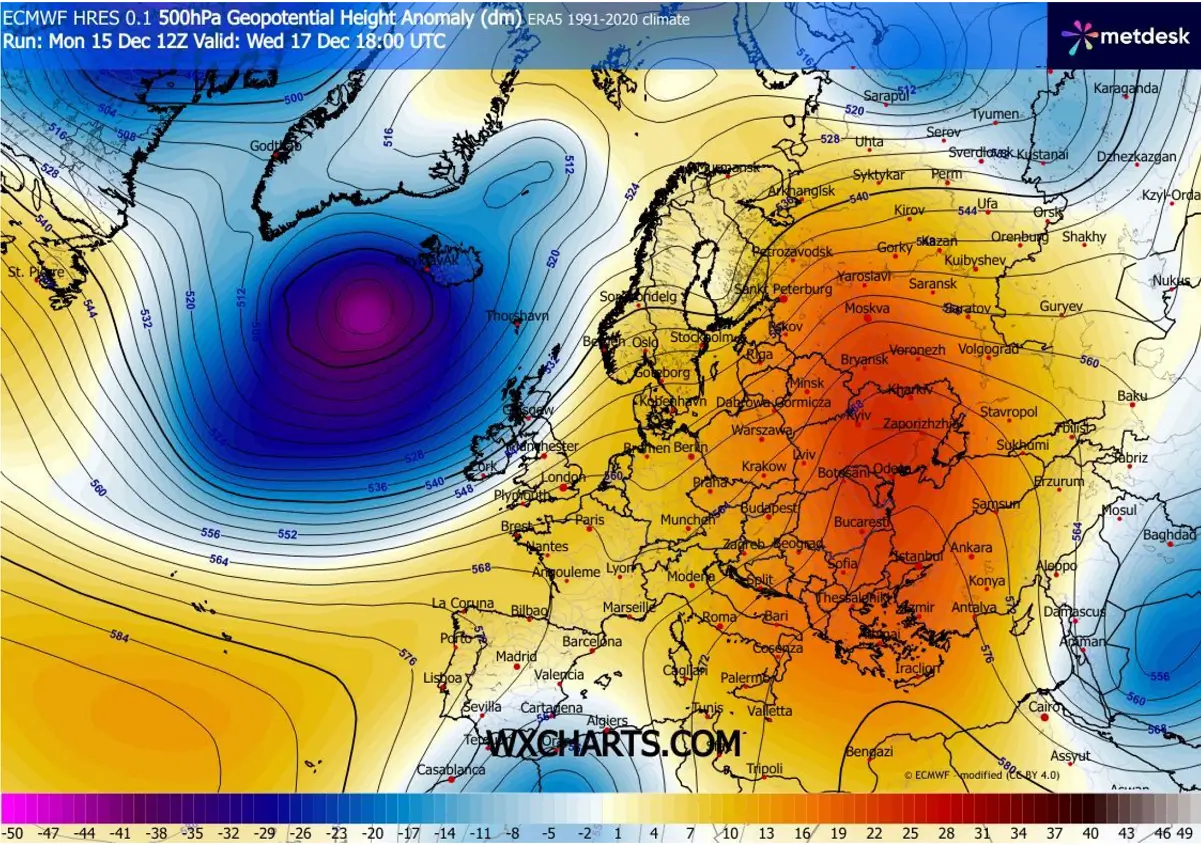
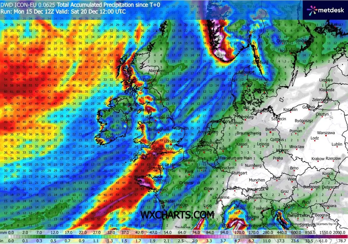
The more or less stationary position of the deep upper low and the cyclone over the Atlantic raises concerns about excessive rainfall along the frontal zone, extending from southern Norway across the south of the UK, northern France, and west of Iberia.
This stalled front will remain nearly in the same corridor for at least 12 hours, bringing heavy rain and excessive amounts, including some storms. And it could result in local flooding across the coastal areas of southern England and northern France.
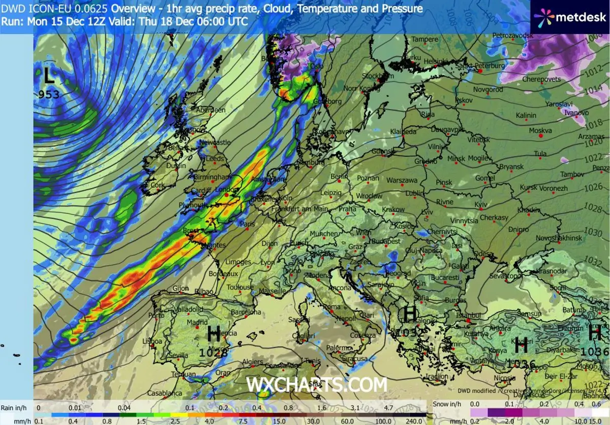
Locally, 60-120 mm of rain could accumulate through Saturday, with the majority of the precipitation on Wednesday along the stalled frontal boundary.
The classic regions where precipitation will be most pronounced are the mountain ranges with the most excellent orographic effects. Those are southern Norway, western Scottish Highlands, and northern England, as well as the regional peak across southern England and northern France, where the stalled front sits on Wednesday.
We continue to closely monitor the evolution of the progressive patterns across North America, the Atlantic, and Europe in the coming weeks. Following the unusually early and significant disruption of the Polar Vortex and its split this winter, conditions are prone to rapid changes. And also make the Christmas snow forecast challenging – see below.
Stay tuned for further updates.
Windy, TropicalTidbits, and Wxcharts provided images used in this article.