A potentially dangerous heavy rainfall event with a high flooding risk will evolve across parts of southern Europe and the Mediterranean this week, associated with persistent southeasterly flow at low levels and abundant moisture in place. A combination of stratiform and convective rainfall could result in widespread 200-400 mm rain accumulations with the upslope flow onto Corsica, Sardinia, and southeast Italy.
The Mediterranean region braces for a period of extreme rainfall, driven by a train of deep lows driving southeastward from the North Atlantic into southern Europe. The most affected areas will be Southern Italy, including Sicily and Sardinia, Malta, and Northern Algeria.
This dangerous multi-day weather setup is being established by an extensive blocking high over Eastern Europe and Russia, which has effectively dammed the usual atmospheric flow, forcing high-energy frontal systems traveling along the narrow corridor towards the warm Mediterranean waters.
The result is a forecast of extreme rainfall and a significantly high flooding risk, as these cyclones tap into abundant moisture to trigger torrential downpours. Residents in the central Mediterranean are on high alert for flash floods, urban inundation, and landslides.
Key Messages:
Persistent Atmospheric Block: A powerful blocking high over Europe is funneling a train of deep lows from the North Atlantic directly into the Mediterranean basin.
Widespread Flood Threat: A significantly high flooding risk for Italy, Sardinia, Sicily, Malta, and Northern Algeria as trapped weather patterns trigger repeated excessive rainfall.
Extreme Rainfall Totals: The collision of cold Atlantic air with warm Mediterranean waters is expected to produce heavy rainfall and life-threatening flash flood conditions.
The current satellite view shows a large high-pressure system over Eastern Europe and Russia, with a deep low over North Africa moving into the Mediterranean. This upper wave is gradually retreating north-northwest across the region on Monday into Tuesday, pooling a warm air mass from the south.
Between these two large-scale systems, a strong and persistent south-southeast flow has established, advecting a high-moisture, unstable air mass into the Mediterranean region.
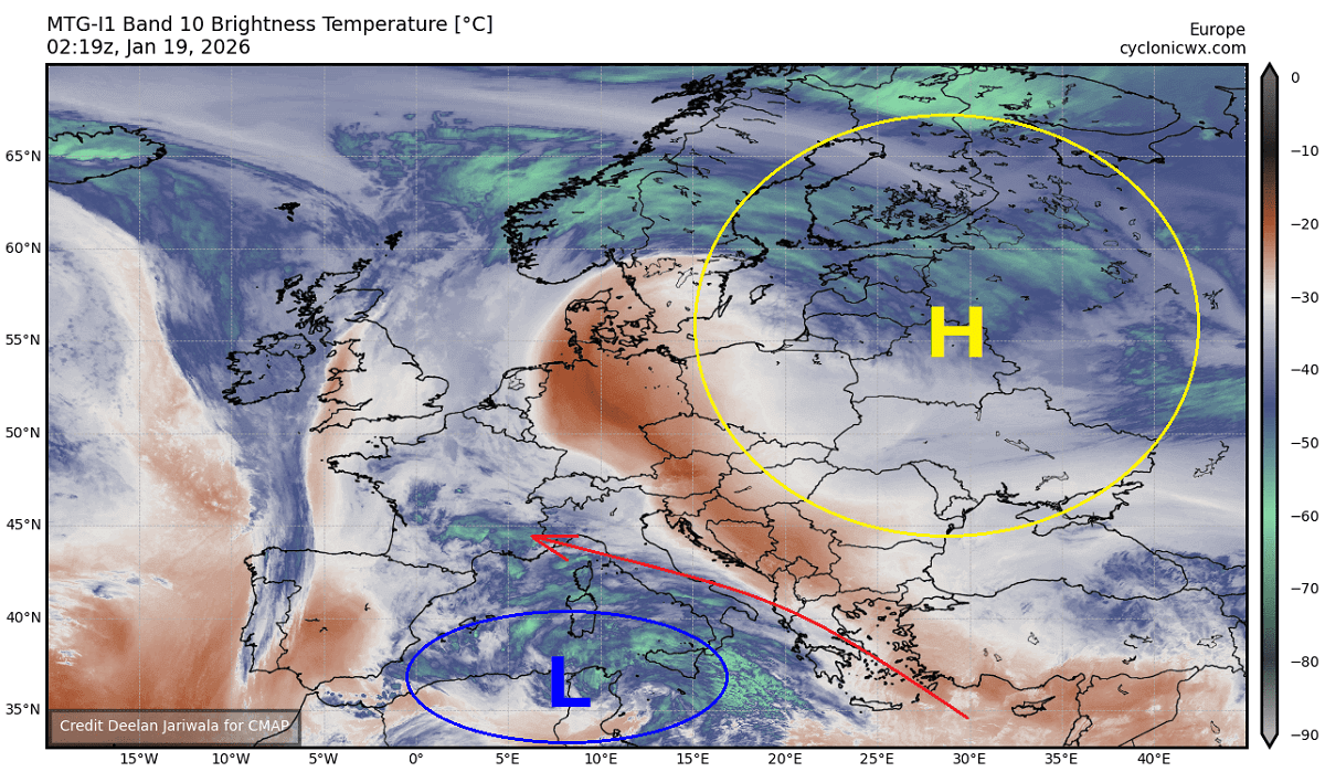
The evolution will gradually unfold over the coming days, with deeper lows emerging from the Atlantic and triggering additional frontal systems in the region.
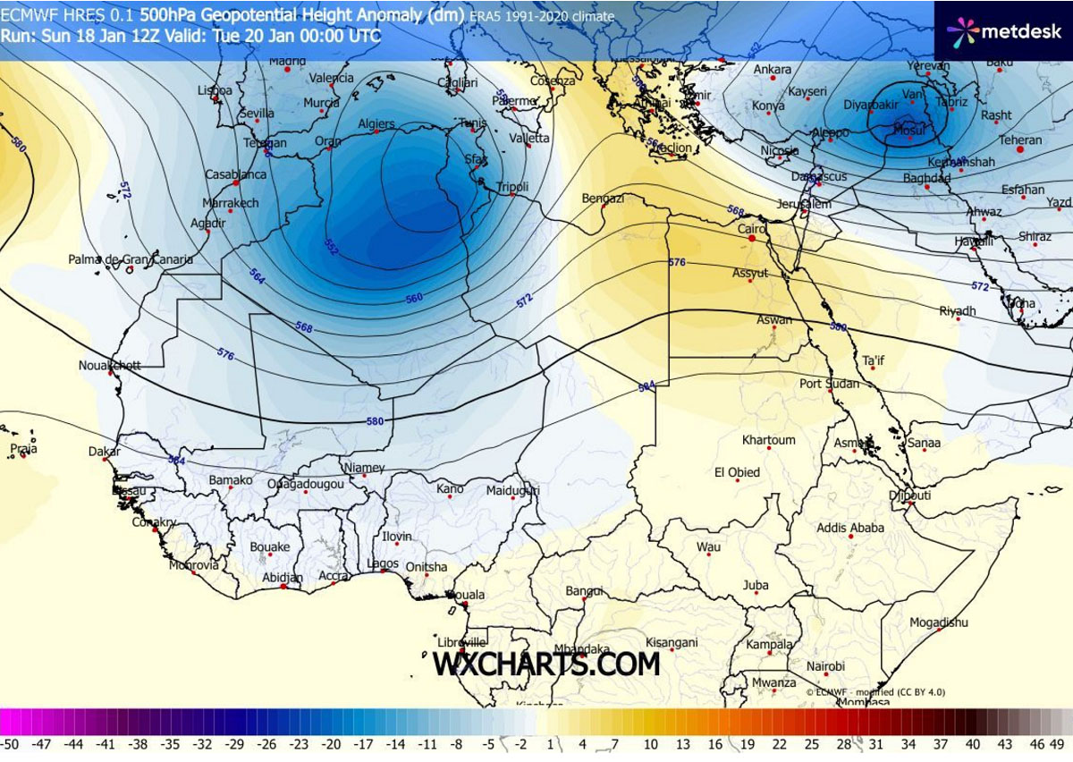
An unusual low over Algeria fuels excessive rainfall events in the southern Mediterranean
A weather pattern over North Africa indicates a rather unusual setup, with a large and deep upper wave transforming into an upper low early this week. It triggered a surface low emerging into the southern Mediterranean.
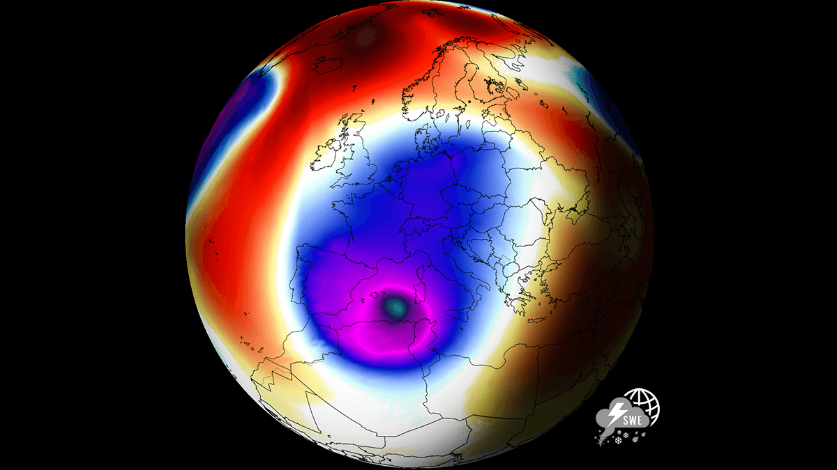
The overall weather picture across Europe and the North Atlantic reveals an impressive situation, with a strong High over Northern and Eastern Europe and another strong ridge over the Azores.
This establishes a broad corridor from Eastern Canada and the Labrador Sea towards Southern Europe, resulting in a train of deep lows and frontal systems that trigger a multi-day rainfall event.
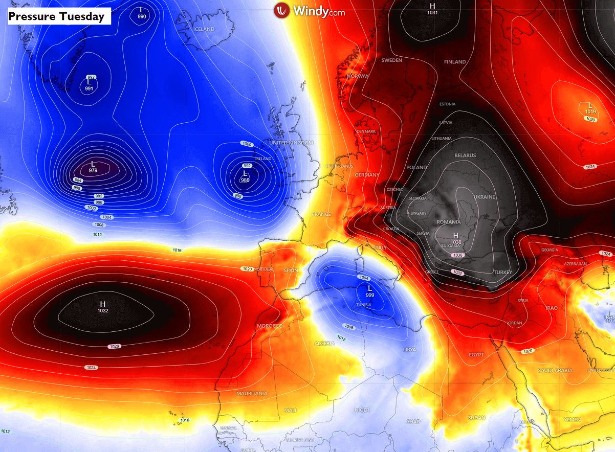
A similar picture is seen on the surface pressure charts. An extensive surface high-pressure system dominates Eastern and Northern Europe and the Azores. While the North Atlantic has a large low-pressure system, a secondary low is trapped over the Mediterranean.
There is a strong temperature and pressure gradient between the High on the East and the Low over the Mediterranean, thus resulting in a persistent, strong southeast flow from North Africa into Southern Europe.
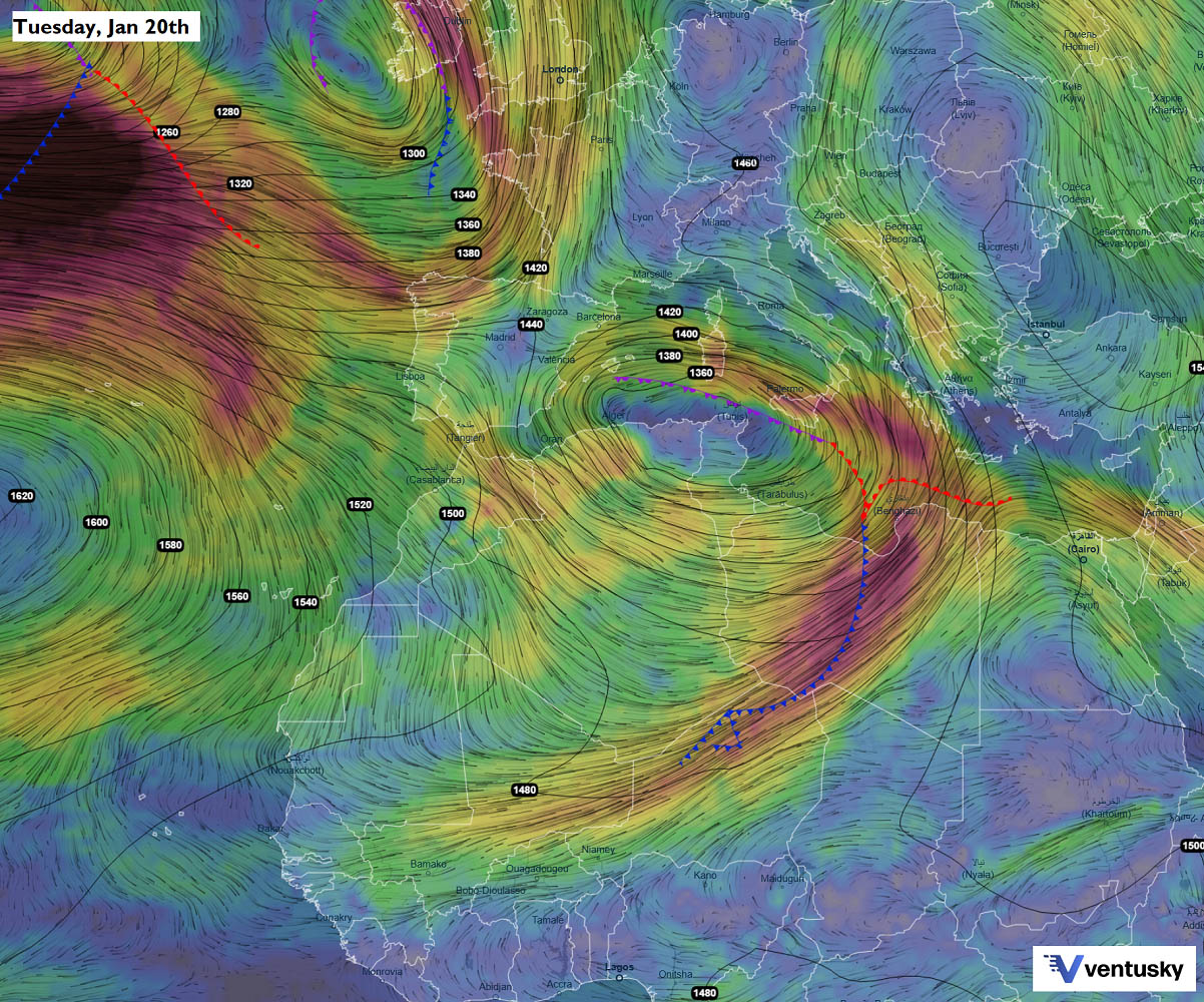
Looking at the forecast of the mid-tropospheric flow on Tuesday, we can see a quite unusual pooling of the warm air mass from southern Algeria across Libya into the southern Mediterranean, curving northwest into southern Italy, Sicily, and Sardinia, then again turning south into northern Algeria.
This is where the general flow will advect high moisture inland, increasing the risk of excessive rainfall. The main low circulation will sit over Tunisia.
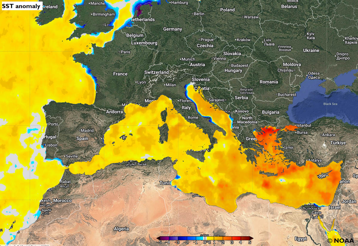
The Mediterranean region is also still experiencing above normal sea water temperatures, roughly 1-3 °C warmer than normal for January. These warm waters are a significant source of moisture.
They will fuel convective storms and advect high moisture, resulting in intense orographic rainfall over the mountainous terrain of South Italy, Sicily, Sardinia, and Northern Algeria.
The significant rainfall threat is expected to persist until next weekend.
Extreme rainfall and high flooding risk will develop for South Italy, Sicily, Sardinia, and North Algeria
Heavy and excessive rainfall threat develops this Monday across the southern Mediterranean and continues into Tuesday as a deep surface low stalls beneath an upper wave aloft. The system’s center will be over northern Tunisia, with a persistent flow from the southeast onto southern Italy, Sicily, and Sardinia.

A large surface low-pressure system will have multiple secondary lows embedded in the broad circulation, traveling from the Libyan coast towards Malta, Sicily, Sardinia, and further west towards North Algeria.
This will deliver multi-day rainfall events across the region, combined with both convective, stratiform, and orographic rainfall. The following video animation hints at the week’s evolution over the region.
As a result, an excessive rainfall threat will develop. The most prone areas are the mountainous regions, where strong, persistent southeast flow will deliver high moisture and result in intense orographic rainfall. It will also be combined with widespread convective activity, especially around Sicily and Malta.
Some areas across Sardinia, Sicily, southern Italy, and northern Algeria could see 200-300 mm of rain through Friday, and potentially even higher rainfall sums will accumulate fast with extreme orographic flow.

The high-resolution weather models show some regions with rainfall sums as high as 500 mm, e.g., over Etna in Sicily and Southern Italy, with Calabria as the prime spot for abundant rainfall.
There, 300-500 mm could not be out of the question if the best combination of convective and intense orographic rain is established. This could trigger deadly landslides and extreme flash floods towards the vulnerable coastal areas.
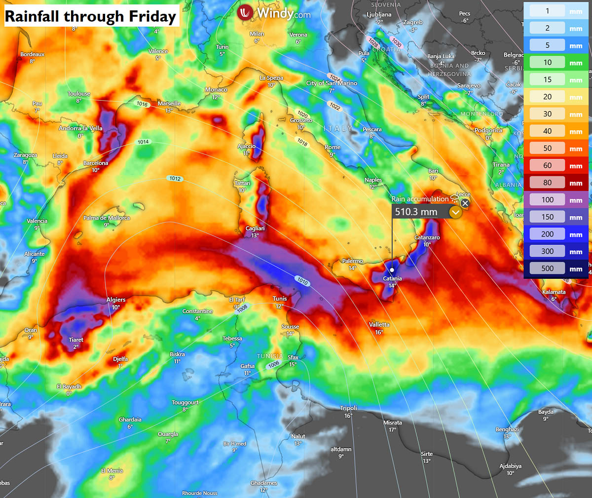
South Italy is already under Red Alert for potential dangerous, life-threatening rainfall and flooding threat.
Could the end of January bring a dramatic change to the pattern and return the Arctic cold to Europe?
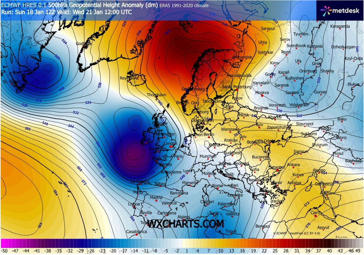
Looking ahead towards the following weekend, global weather models hint at a potentially large and deep North Atlantic trough extending into western and southwestern Europe, delivering a warmer air mass and more moisture into Southern and Central Europe.
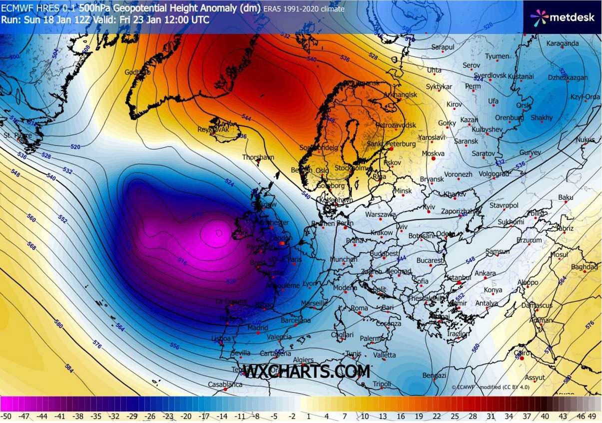
There is still a major blocking High forecast to remain across the North, expanding into the Arctic region and Greenland.
This is what several model runs have been hinting at recently: a potential blocking, as shown in the chart below, that would trigger an intrusion of Arctic air from Russia towards central Europe.

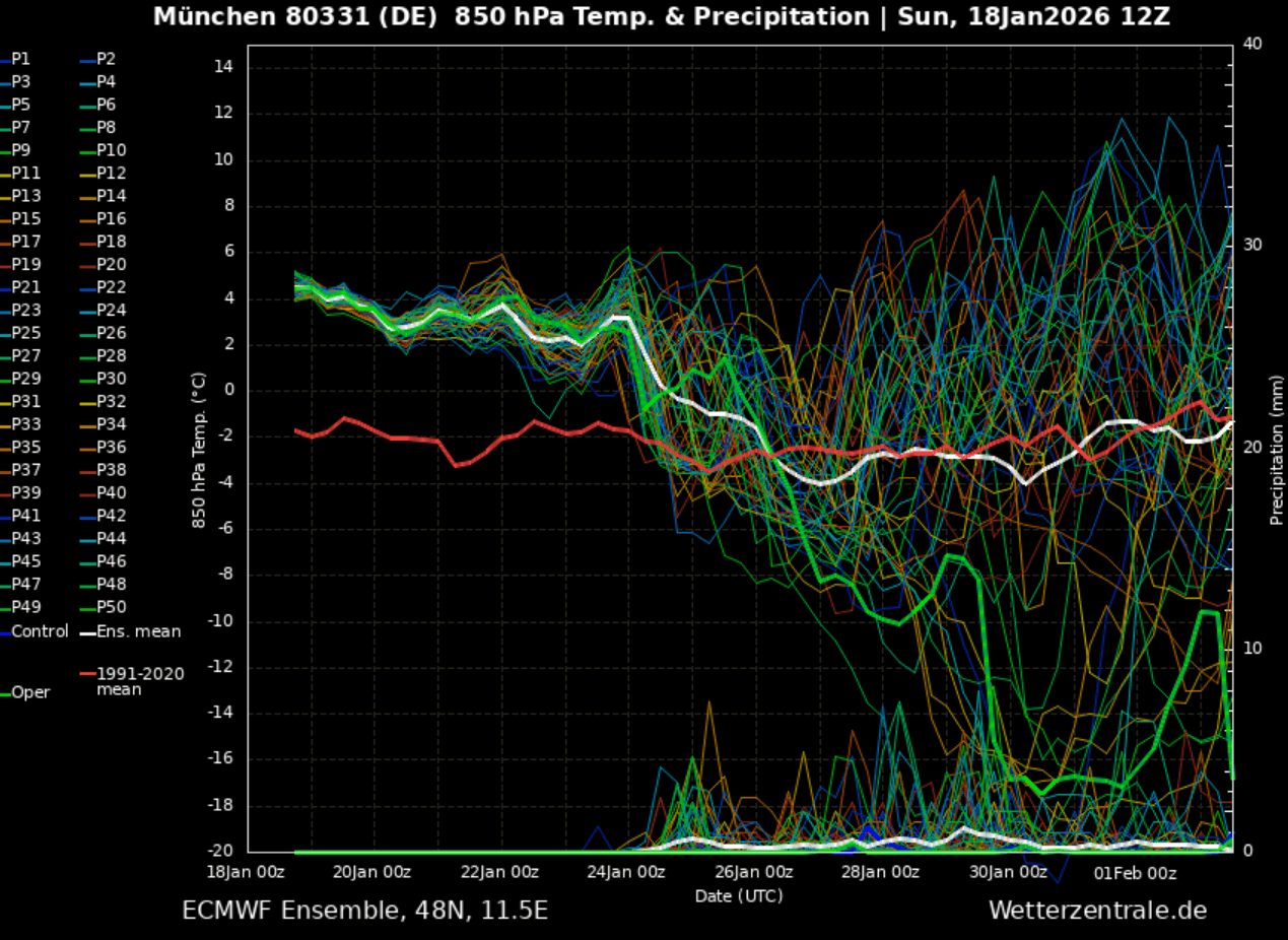
Here is a brief look at the meteogram chart for Munich, Germany, through the end of January. Temperature trends suggest it will become colder over time, with the potential for significant cold outbreaks in the final days of the month.
However, the probabilities remain low for days after the following weekend, so these forecasts should be taken with high uncertainty until the general weather patterns clear.
This pattern from the north-northeast usually delivers extreme polar cold and a dry air mass onto the European continent. We are closely monitoring weather trends and will update as more details and higher probabilities become available.