The silence before the massive clash of Arctic cold and the southern warmth is over. The significant disruption of the Polar Vortex has done its work: the behemoth Winter Storm Fern is on the way to bring wintry havoc, impacting 200 million people from Texas through New York and Boston.
A massive corridor of deep snow is set to bury cities from Oklahoma City to Boston, with the Northeast bracing for 15 to 30 inches by Monday evening. Further south, a dangerous ice storm is forecast to glaze up to an inch and a half across 1,800 miles stretch from the heart of Texas to the Virginia coast.
![]()
![]()
The intensity of the snowfall and major ice storm threatens to render de-icing and plowing efforts across hundreds of airports, effectively paralyzing the nation, likely causing historic flight cancellations and widespread power outages over the weekend.
Fern has triggered the most extensive Winter Storm Warnings seen in nearly two decades.
![]()
![]()
*Note: This post is regularly updated as the system evolves. The most recent update is always at the top of the article. Feel free to bookmark the link and stay tuned.
Jan 25th, 23:00 UTC update: 15 to 30 inches of snow from Oklahoma to Boston
As the general weather model consensus predicted, around 15-30 inches of snow has occurred along the core of the Winter Storm Fern’s center. The most significant snow has spread from central Oklahoma across the mid-Mississippi and Ohio Valleys to the Mid-Atlantic and Northeast U.S.
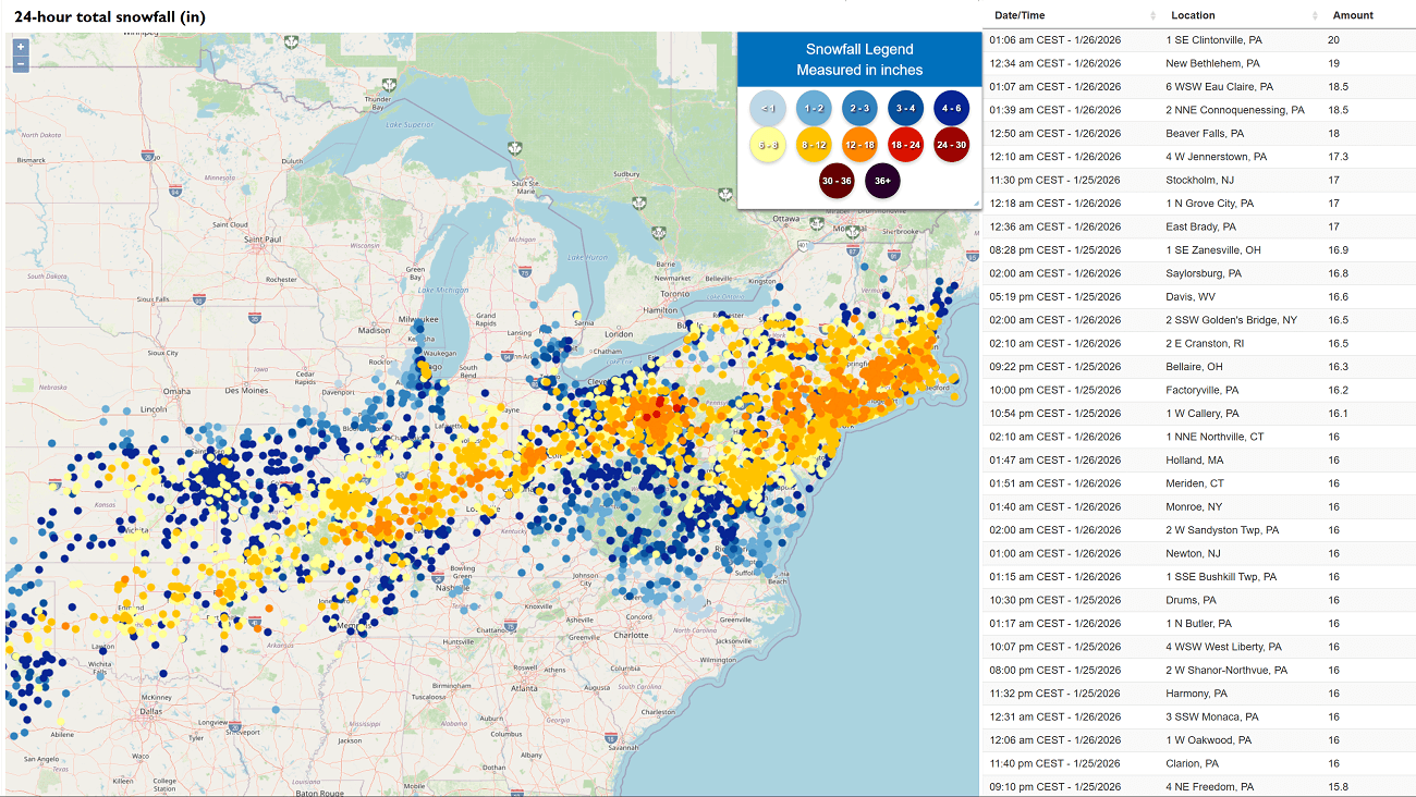
The highest amounts of snow are reported from southern Illinois and Indiana to Ohio and New York state, Pennsylvania, to Connecticut, Rhode Island, and Massachusetts.
New York City has received 12-15″ of snow, while up to 20″ has accumulated across Rhode Island and Boston.
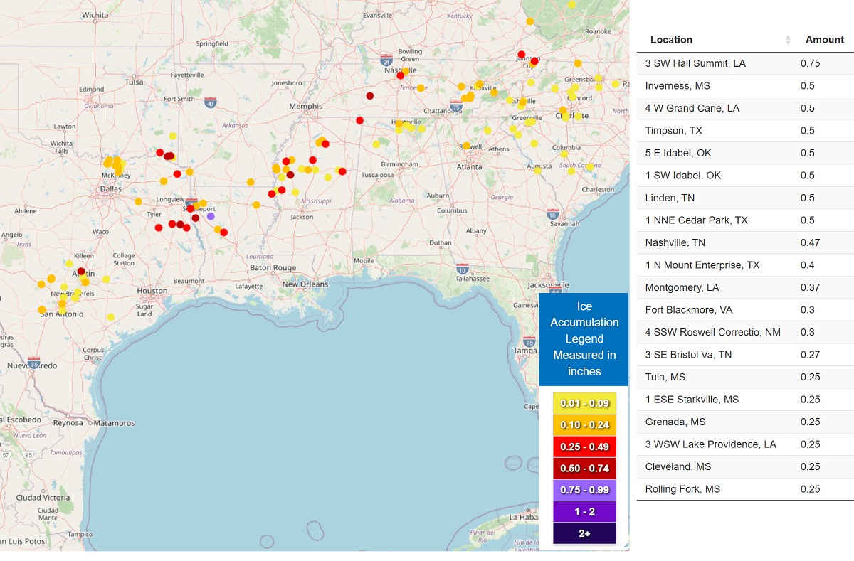
Jan 25th, 22:00 UTC update: 0.75″ to 1 inch of ice accumulation across 1,800 mile swath
A significant black ice accumulation has formed along a broad corridor from San Antonio, TX, across Jackson, MS, to Nashville, TN, with a thickness of 0.5-1 inch. Severe tree and structural damage has been reported, wind hundreds of trees downed. Some localized areas have received up to 2″ of ice thickness.
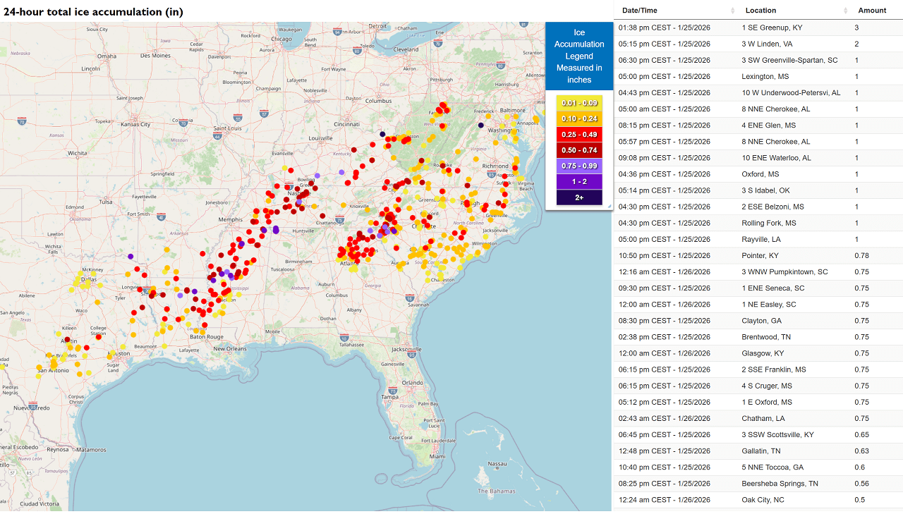
Another swath of ice accumulation has been reported from Atlanta, GA, across Charlotte, NC, and Washington, D.C., and Baltimore, MD. Ice thickness has also been accumulating across Virginia and both Carolinas.
The worst impact is along the southern stretch of this corridor, from Atlanta to Charlotte, where 0.5″ to 1 inch of accumulated ice has been reported.
Conditions are gradually vanishing as on this late afternoon, as the frigid cold air mass behind the Polar front is finally mixing rain to snow and decreasing precipitation rates.
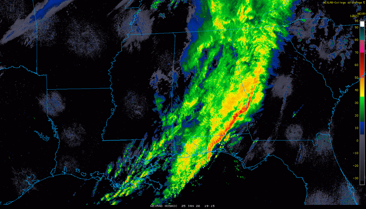
Jan 25th, 20:00 UTC update: Polar front racing across the Southeast U.S. and the Gulf
A spectacular visible satellite spectrum of the Polar front moving across the Gulf of America in the final hours of the daylight. A much colder air mass behind the sharp frontal edge is well visible with the cloud deck spreading south across the sea.
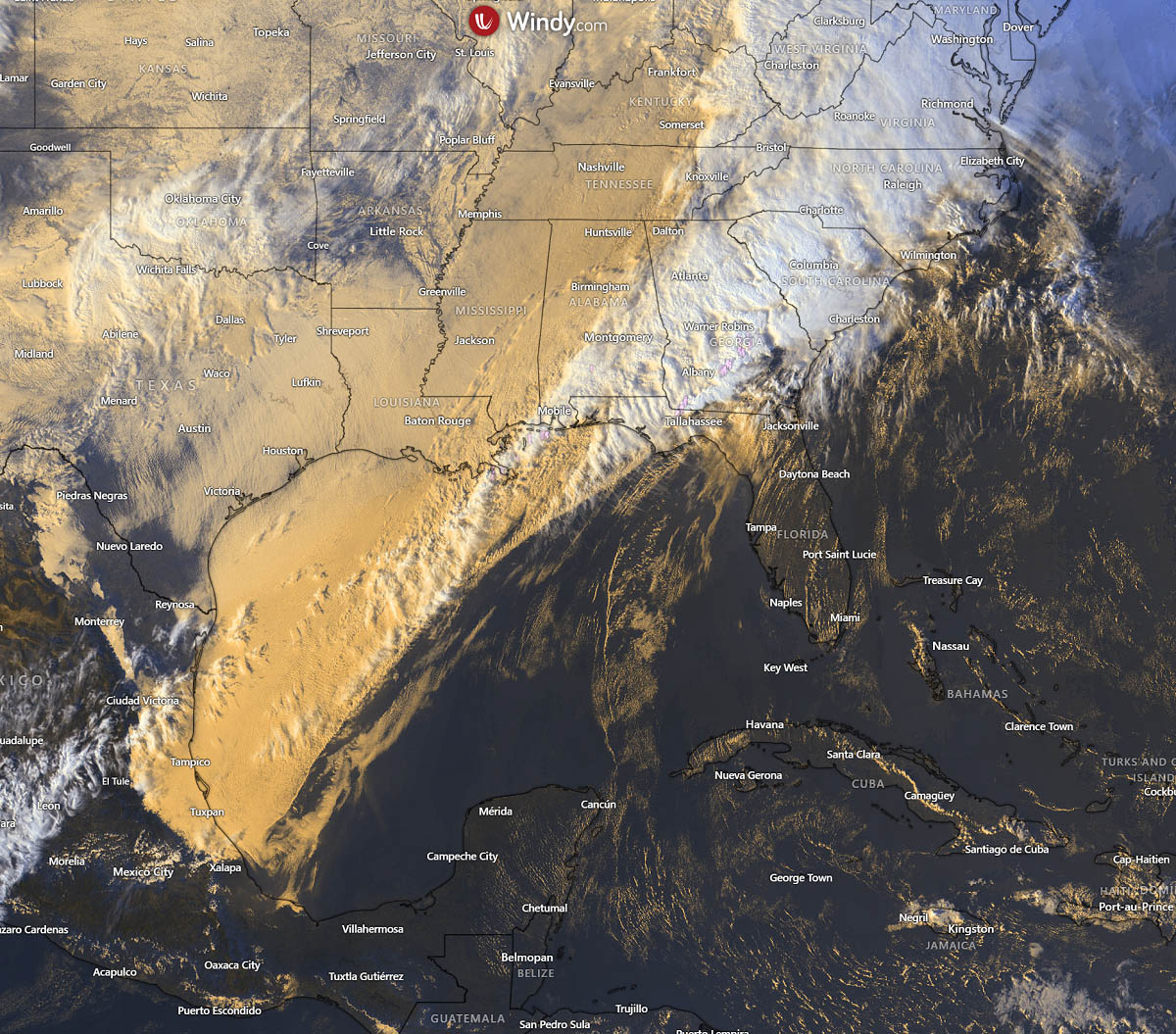
Looking over the water vapor spectrum, we can see the Winter Storm Fern continues across the Mid-Atlantic and Northeast U.S. with heavy snowfall and freezing rain across Virginia and the Carolinas.
Another weak wave is emerging into the Plains, with additional snowfall over North Texas and Oklahoma.
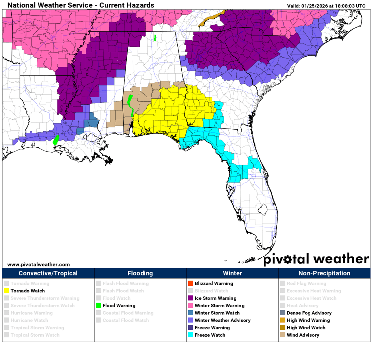
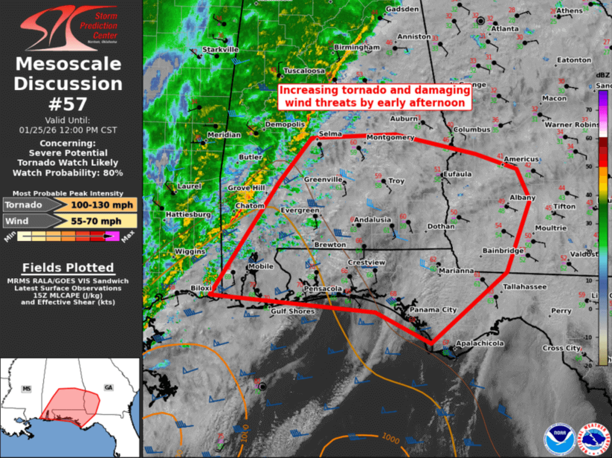
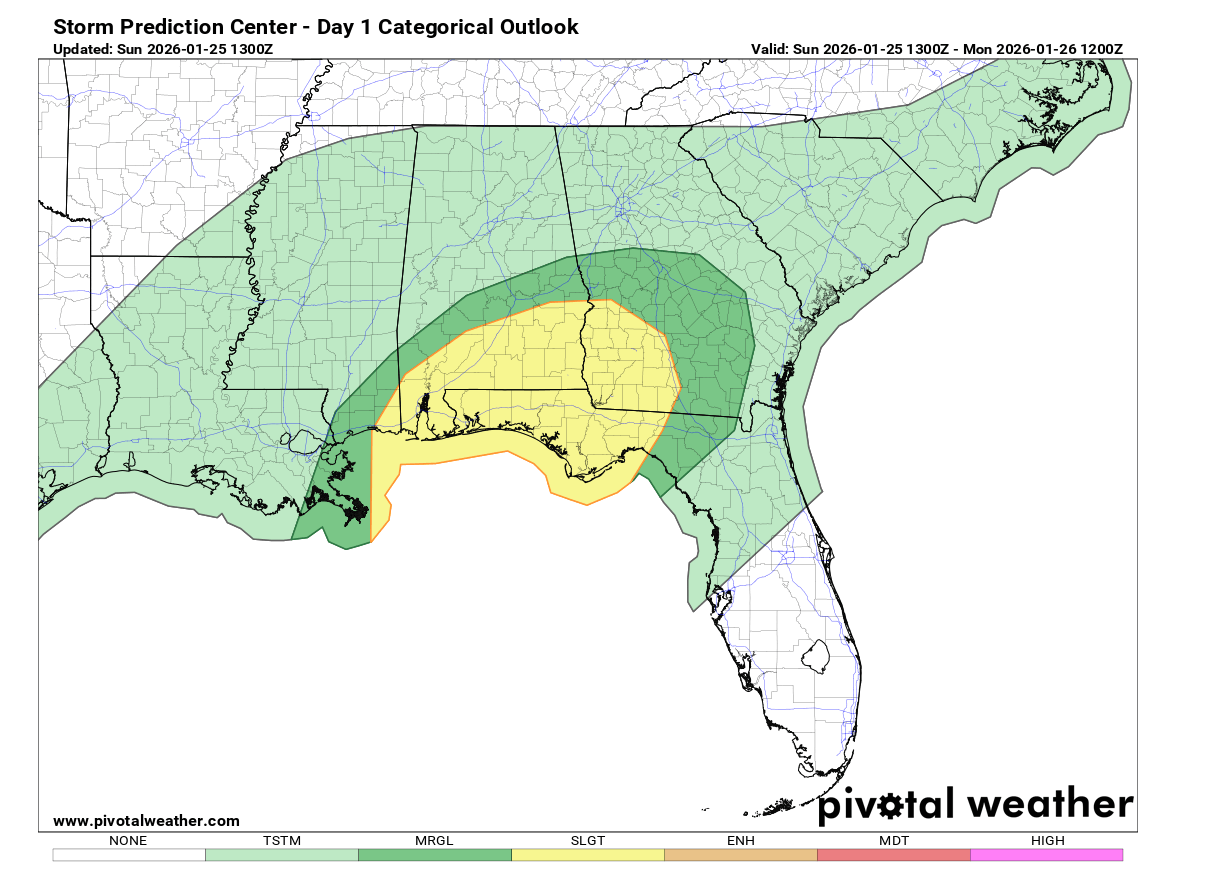
Jan 25th, 17:00 UTC update: Tornado watch is in effect for SE Alabama, SW Georgia, and the Florida Panhandle
Primary threats include…
- A few tornadoes are possible
- Scattered damaging wind gusts to 70 mph possible
SUMMARY … Thunderstorms are intensifying along a cold front over western Alabama. This activity will spread eastward through the afternoon, posing a risk of damaging wind gusts and a few tornadoes. Sporadic damaging winds and potential for a few tornadoes should persist into late afternoon with a QLCS progressing eastward.
DISCUSSION … A low-topped QLCS has been quickly moving east along a cold front sweeping through southeast AL to the far western FL Panhandle. Pre-frontal convection has remained linear as well, with an upcoming merger of the two lines over far southeast AL shortly.
Surface winds have consistently veered just ahead of the front, reducing low-level SRH. But the presence of a confined corridor of mid 70s surface temperatures from the central FL Panhandle into extreme southeast AL may support deepening convection into mid-afternoon, centered on the Chattahoochee Valley.
Overall, the severe threat will become more spatially limited towards late afternoon as the QLCS is likely to outpace the northeast extent of the surface-based instability plume.
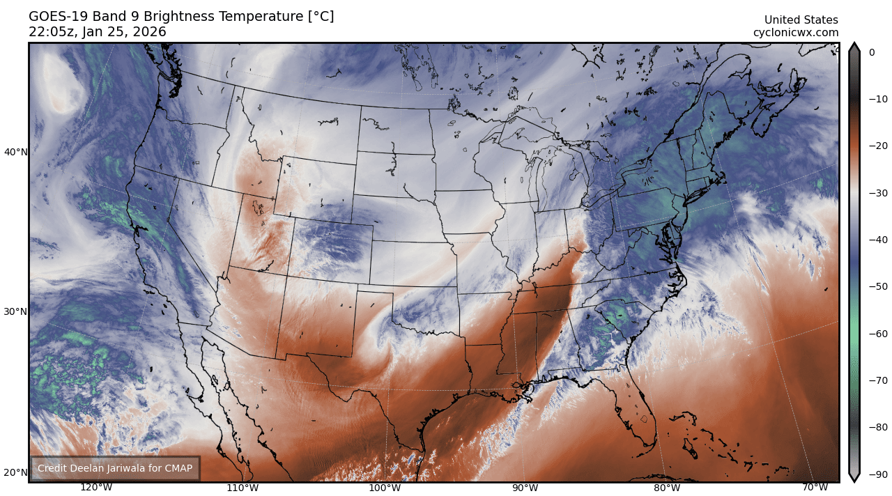
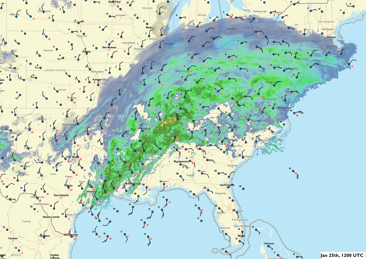
Jan 25th, 16:30 UTC update: Morning satellite view over the United States
Winter Storm Fern has grown into a large frontal system, with an impressive cloud shield covering the eastern half of the country. A frigid Arctic cold air mass is spread behind the polar front, while a subtropical air mass is delivering high moisture into the Southeastern U.S.
Heavy snow, sleet, and heavy freezing rain continue along the frontal corridor, stretching from Missouri, Arkansas, and Louisiana on the west all the way through the far Northeast U.S. states. Severe winter conditions continue as the storm moves towards the Mid-Atlantic region.
More than 1,000,000 customers are now without power as widespread structural and tree damage has been reported. More than 20,000 flights have been grounded and cancelled until further notice, and the storm has passed.
Jan 25th, 16:00 UTC update: Severe weather potential with Tornado Watch likely
Areas affected: southern Alabama, Florida Panhandle, and southwest Georgia
Valid 251555Z – 251800Z
SUMMARY … Severe potential will likely increase into early afternoon with a QLCS and embedded supercells capable of producing damaging winds and tornadoes. A tornado watch will likely be needed.
DISCUSSION … Along a pronounced cold front to the south-southwest of a surface cyclone between TCL and SEM, convective intensities appear to be increasing to the central Gulf Coast. Pre-frontal cells have also increased over the past hour, and an increasingly severe threat is anticipated as activity matures over the next 2-3 hours.
While pervasive downstream cloud coverage is limiting boundary-layer heating in the confined warm-moist sector, 60s surface dew points are sufficient for weak to modest MLCAPE from Mobile Bay and the western FL Panhandle northward into south-central AL. This warm-moist sector will shift east through the afternoon and likely reach southwest GA to the eastern FL Panhandle.
Low-level shear is quite strong with enlarged hodographs favoring mesocyclone/mesovortex development. Expectation is for a QLCS to evolve eastward through the afternoon, with a threat of damaging winds and brief tornadoes. If semi-discrete supercells can form ahead of and merge into the QLCS, a longer-tracked tornado or two is possible.
Jan 25th, 15:00 UTC update: Already more than 800,000 customers without power
More than 800,000 homes and businesses have lost power as of Sunday morning, and numbers are rising fast as a crippling ice storm is glazing communities across the southern states. Expect more widespread power outages over the next 12-24 hours.
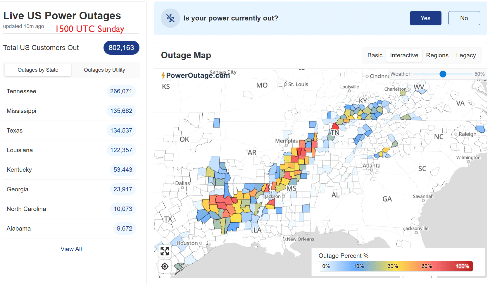
In the latest update from PowerOutage.us, outages have surged significantly in Louisiana, Mississippi, and Tennessee, with more than 100,000 added to the total numbers. Conditions are worsening fast, along with heavy freezing rain underway.
Jan 25th, 14:00 UTC update: Severe thunderstorms are possible across portions of the Southeast states, including tornadoes
Severe thunderstorms are possible across portions of the Southeast states this morning and afternoon. Damaging gusts and a few tornadoes are the main concerns.
The Storm Prediction Center has updated its outlook for Sunday:
…Portions of the Southeast States…
Early-morning satellite imagery shows a southern-stream shortwave trough moving across the southern Plains and into the more single-stream confluent flow across the eastern CONUS. Surface analysis shows the low associated with this shortwave over the vicinity of the central MS/AL border.
A cold front extends from this low southwestward through southeast LA and into the western Gulf. A combination of these features comprises the large winter storm system impacting much of the central and eastern CONUS.
Recent regional radar imagery and surface observations reveal an extensive anticyclonic system of showers and thunderstorms from east TX into MS and the TN Valley. Much of this precipitation is falling as freezing rain or sleet, with sporadic lightning accompanying it across east TX, northern/central LA, and western/northwestern MS.
Currently, the warm sector, which extends from southeast LA across southern AL and southern MS into the FL Panhandle, is free of any thunderstorms. This is expected to change throughout the morning as continued moisture advection further modifies the airmass and modest buoyancy develops ahead of the advancing cold front.
Despite the fast progression of the cold front, strong deep-layer vertical shear should allow for the maintenance of deep convection along the frontal zone once it begins to encounter the modest buoyancy. Additionally, the strong vertical shear should allow some organization/rotation within deeper, more persistent updrafts.
Damaging gusts appear to be the primary severe risk, with the risk concentrated from southern AL and the western FL Panhandle into southwest GA and the central FL Panhandle, where the best thermodynamics (i.e., 500-1000 J/kg of MLCAPE) are forecast.
Low-level shear is strong enough to support a tornado risk in this area as well, with the linear nature of the convection favoring brief cell-in-line/QLCS circulations (in contrast to a more discrete, supercellular mode). A few discrete cells ahead of the line cannot be ruled out entirely.
However, limited residence time due to the fast-moving front and the likely shallow character of the flow, due to limited buoyancy, should prevent these updrafts from maturing.
Jan 25th, 12:30 UTC update: Winter Storm Fern is intensifying as the wave emerges from Mexico
Freezing rain and sleet, with thunderstorms, have been reported in Houston, Texas, as more cold air has arrived in the deep south.
Heavy freezing rain with significant, 0.5 to 0.75″ ice accumulation.
Widespread power outages and tree damage have been reported from north-central Louisiana through Mississippi and Tennessee.
Heavy snow continues spreading further north and east across the southern Great Lakes and the Mid-Atlantic states.
Jan 25th, 12:15 UTC update: More than 13,000 flights cancelled, with more to remain grounded through Monday
24 states have now officially declared a State of Emergency due to the storm.
Nationwide, more than 13,000 flights have been canceled since Saturday, with 10,000 grounded today. Major travel disruptions are underway as conditions are worsening with the Winter Storm Fern blasting deep snow, sleet, and freezing rain across the nation.
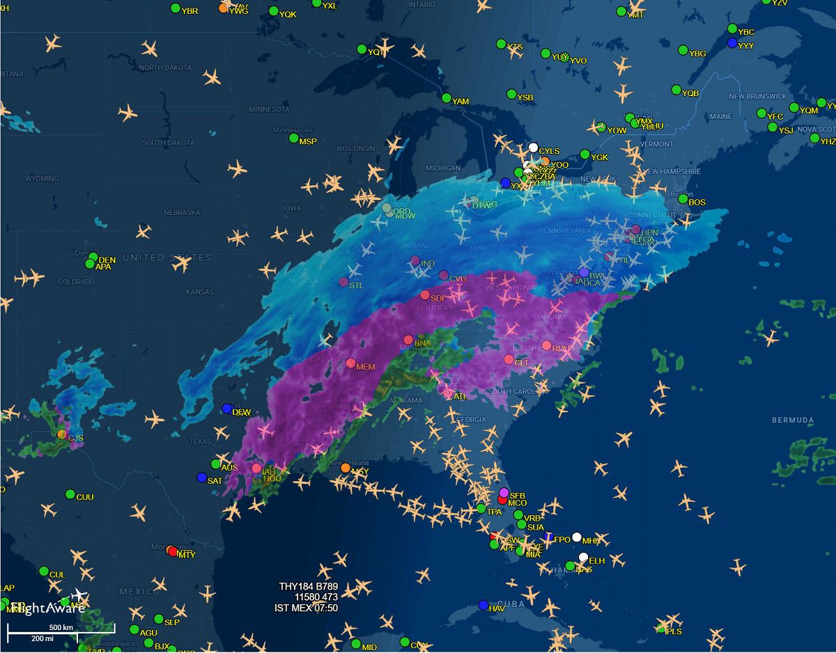
Major delays have affected most flights at Ronald Reagan Washington National Airport and at hubs like Charlotte, Atlanta, New York, Philadelphia, and Dallas-Fort Worth. Major disruptions are expected to worsen on Sunday and continue into Monday as the storm moves toward the East Coast.
Jan 25th, 05:30 UTC update: Winter Storm Fern is intensifying as the wave emerges from Mexico
An impressive water vapor satellite image below reveals a large frontal system associated with the powerful upper wave, emerging into the southern U.S. states from Mexico.
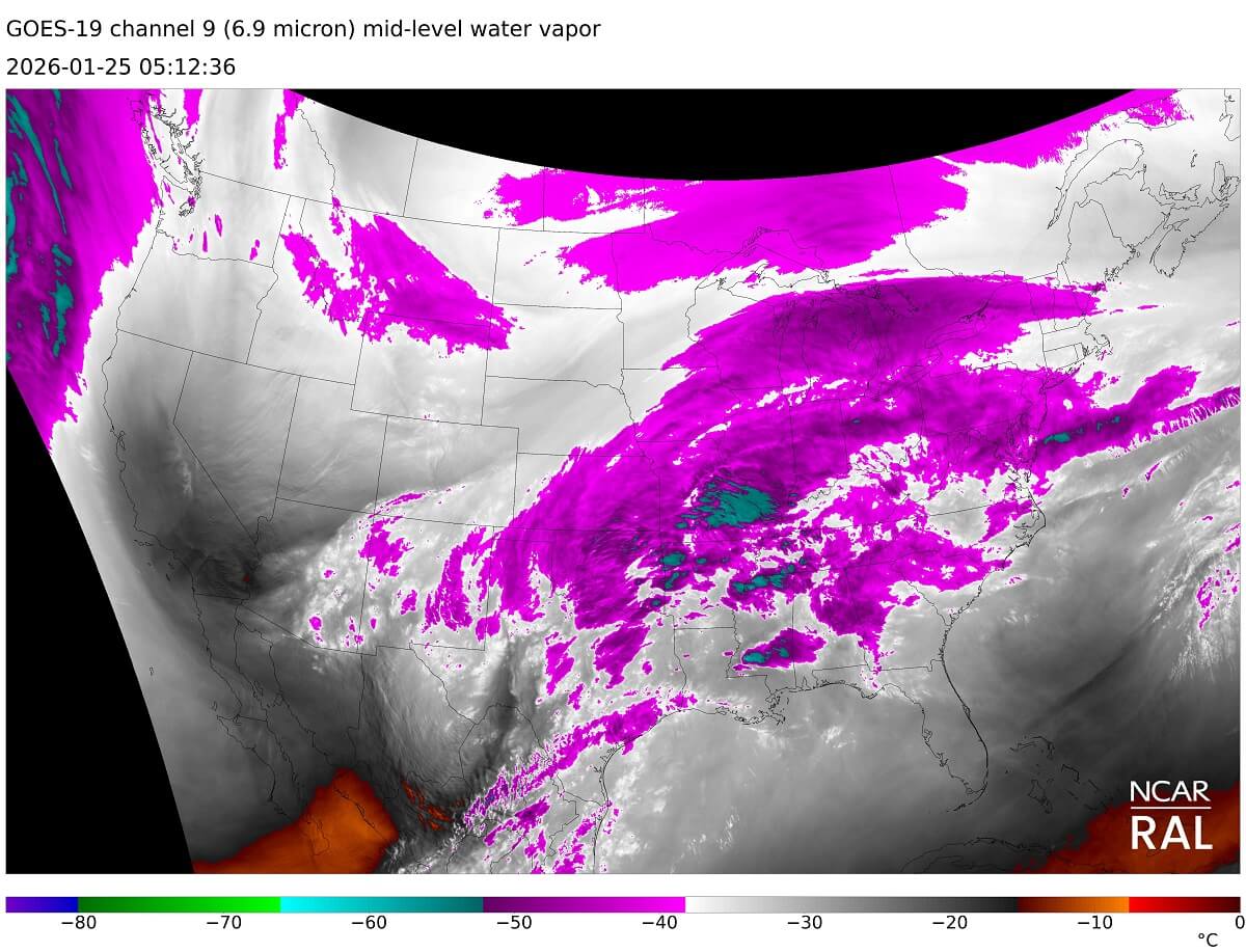
A broad moisture pool is observed, delivering high humidity northward into Texas, Oklahoma, and into the low to mid-Mississippi Valley, where heavy freezing rain and snowfall are intensifying tonight.
Driving conditions are rapidly worsening, causing numerous road accidents and impassable highways.
Jan 25th, 05:00 UTC update: Polar front grazing south, reaching Texas Gulf Coast
The polar cold front continues grazing south across the nation, with temperatures near freezing now reaching the Texas Gulf Coast by midnight Saturday. A warm air mass remains further east along the coasts of Louisiana, Mississippi, and Florida, pumping high moisture towards the north.
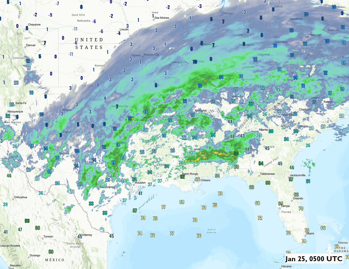
Heavy snowfall is underway across a large part of Texas, Oklahoma, eastern Kansas, and Missouri to Illinois and th Ohio Valley, with mixing sleet and heavy freezing rain in the narrow corridor from Eastern Texas across Louisiana and Missisippi to Tennessee.
Jan 25th, 02:30 UTC update: Textbook vertical profile from Dallas-Fort Worth airport
The Saturday’s 12 UTC vertical sounding profile analysis revealed a sharp temperature inversion, with around 8 °C at the 800 mbar level (approx. 1500 meters above sea level) and nearly -8 °C at the ground.
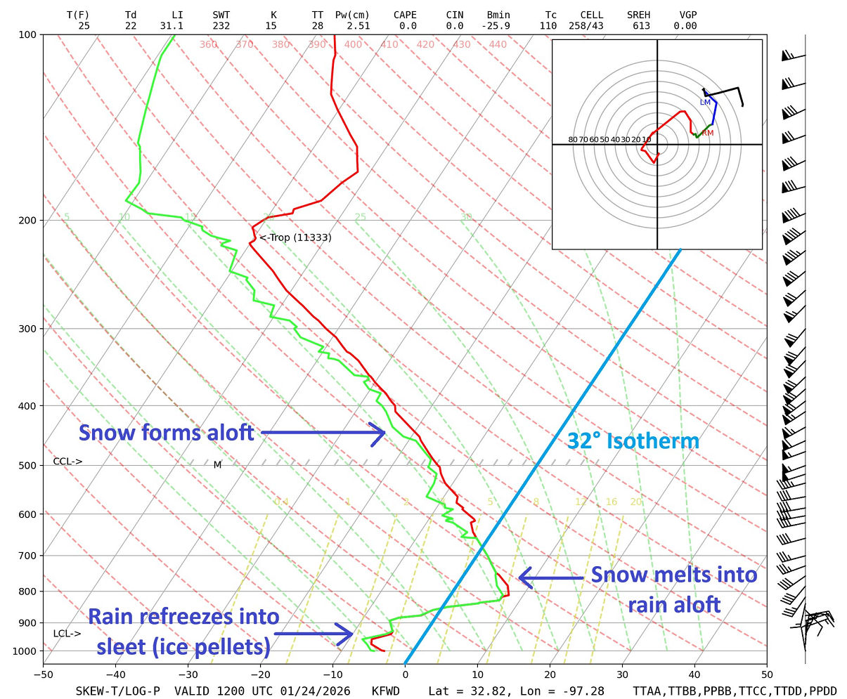
This extreme temperature difference confirms why the ice storm is underway. As snow falls into the lower parts of the atmosphere, snowflakes melt in the warm layer, then refreeze as water droplets pass through the air below freezing near the ground.
This forms sleet (ice pellets) and significant freezing rain with black ice accumulation on cold surfaces, including roads and trees.
The fierce Winter Storm Fern is clearly visible on satellite imagery, with a huge mass of moisture from the south and a rapid Arctic front and frigid cold air mass spreading south.
![]()
![]()
The image hints at a rough storm path for Monday evening.
Key Messages
Historic Magnitude: Fern represents the most widespread winter weather emergency since 2008, impacting 200 million people across two dozen states.
The Ice Storm 1,800-mile corridor: A long corridor of destructive freezing rain and black ice is forecast from North Texas into the Carolinas. Ice accumulations approaching 1.5 inches could overwhelm power infrastructure, snap trees and power lines, and paralyze transportation networks across the region.
The Snow Bomb and Infrastructure Paralysis: Up to 30 inches of snow and severe ice storms threaten widespread power outages and 6,000–8,000 flight cancellations from North Texas to the Northeast.
Frigid Cold: From Canada into the Midwest and the Great Lakes, a season’s record-breaking Arctic cold is turning wet roads into treacherous black ice, creating hazardous travel conditions that could last for days. A frigid cold air mass combined with winds will result in extreme windchill temperatures.
![]()
![]()
Widespread power outages and significant travel disruptions are forecast to ripple across two dozen states, affecting 200 million people from Texas to the Northeast U.S.
Whether you are in Dallas, Little Rock, Atlanta, or Washington, D.C., the time is running out to prepare for the massive Winter Storm Fern.
Winter Storm Preparation Checklist
- Fully charge mobile phones and all essential electronic devices
- Ensure flashlights are available and equipped with fresh batteries
- Store an adequate supply of water for drinking and cooking
- Maintain at least a one-week supply of food and essential medications
- Keep non-perishable food items and a manual can opener accessible
- Park vehicles away from trees and overhead power lines
Let’s get you prepared now.
Polar Vortex triggers frigid Arctic blast across North America, with impactful Winter Storm Fren crippling 200 million across the U.S.
A powerful Omega blocking High is parked over the Pacific Northwest and Alaska, acting as a dipole weather pattern with a deep Polar Low digging south from Arctic Canada into the United States to its east.
The Polar air mass also results in a major rise in surface high pressure, with a broad 1040-1050 mbar blocking high dominating most of Canada and the US for the following weekend into early next week.
![]()
![]()
This is a perfect scenario for significant cold advection from the south, as the Polar Vortex sends its southern lobe deep across North America.
And the clash of the frigid cold air mass with the warmer south is triggering a behemoth Winter Storm Fern.
A major snowstorm and dangerous freezing rain will bring weather havoc in two dozen states
A swath of deep snow will blanket millions from North Texas and Oklahoma, to the mid-Mississippi and Tennessee valley, the Mid-Atlantic, and the Northeast. Up to 2 feet of snow (15-30 inches) will be possible where the clash between the Polar front and the subtropical airmass from the Gulf will be most intense.
A broad corridor of deep snow is set to bury cities from Oklahoma City to Boston, grounding thousands of flights and causing severe travel disruptions.
![]()
![]()
South of the snow bomb, a narrow corridor of dangerous weather will form. With strong, warm advection in the midlevels and the polar air mass meeting the surface, it will result in a major ice storm across a 1,800-mile stretch, from East Texas across the southern States to the Carolinas.
Some areas along this broad swath of freezing rain, sleet, and ice storm would receive 1.5 inches of black ice.
![]()
![]()
While the core of Winter Storm Fern will bury tens of millions into deep snow, the impacts of the Fern’s icy side will lead to a major damaging event with significant tree damage, widespread power outages, major travel disruptions, and impassable roads.
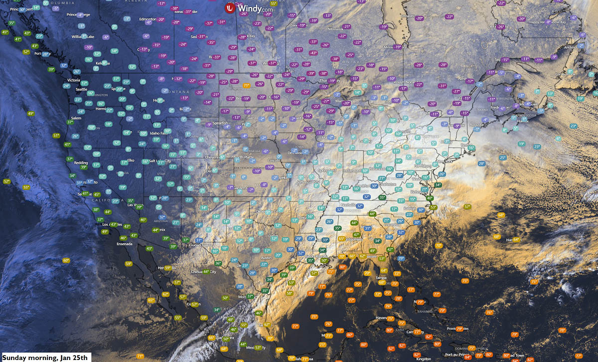
The frigid cold spreads across the nations, bringing the season’s coldest Arctic outbreak
With the deep core of the Polar Vortex southern lobe aloft, the most significant Arctic air mass intrusion is blasting south across North America, sending tens of millions into a deep freeze.
The Polar front is now almost at the Gulf Coast as of Saturday midday.
![]()
![]()
The core of the Polar low is pretty intense, with frigid temperatures 40-50 °F below normal.
Sharp temperature drops are observed as the Arctic front grazes its path south across the CONUS, with temperatures 30-50 °F lower than those experienced just 24 hours ago.
![]()
![]()
The Cold will continue east-southeast behind the Winter Storm over the weekend, bringing frigid low temperatures into the Mid-Atlantic and the Southeast U.S.
Since there’s nothing to stop the extreme cold from reaching the Gulf Coast, the major Arctic cold pool will push temperatures 35-50 °F below normal in Texas and the South through Monday and Tuesday.
![]()
![]()
With strong winds behind the Polar front, extremely low windchill temperatures are forecast. Those will be in the -30 to -40 range across the northern and central U.S. into Canada, with local areas below -50 °F and low wind chills possible through Saturday.
A frigid cold air mass with dangerously low wind chill will also develop across the Midwest, the Great Lakes, and the Ohio Valley. Resulting in more lake-effect snow around the Lakes.
Looking ahead: A major Stratospheric Warming is foreseen in early February, potentially resulting in another significant disruption of the Polar Vortex.
See details below: Stratospheric Warming Alert: A Massive Shift in the Polar Vortex is Forecast for early February
Windy, PivotalWeather, and Wxcharts provided images used in this article.