The Azores brace for Hurricane Gabrielle’s impact on Thursday and Friday. A significant impact from high storm surge, waves, and wind blasts is expected overnight. Then, the Category 1 hurricane transitions into a post-tropical storm and heads for Portugal’s landfall on Saturday.
Hurricane Gabrielle is the 8th tropical system in the Atlantic Hurricane Season 2025 and the second hurricane to form. What’s concerning about this hurricane is its intensity and forecast track: It will travel right over the Azores archipelago on Thursday night into Friday.
Hurricane Gabrielle peaked as a major Category 4 storm while passing east of Bermuda Monday night before sharply turning northeast and accelerating towards the Azores. The peak sustained 1-minute wind was 220 km/h (140 mph), with the central pressure bottoming at 948 mbar.
As of early Thursday morning, Gabrielle has packing winds of 165 km/h and a central pressure of around 966 mbar, located at 36° North and 47° W. It is moving east quite fast, with a speed of 24 knots within the zonal mid-latitude flow.

Gabrielle’s satellite presentation indicates the hurricane is contending with increasing westerly shear. The images reveal that the vortex is tilted with height, and the western side of the inner core has been eroded.
The overall cloud pattern has taken an oblong shape, but the storm maintains its powerful strength as it moves towards the Azores.

Gabrielle is forecast to approach the Azores late on Thursday as a hurricane. A Hurricane Warning is in effect for all of the Azores’ islands, and hurricane conditions are likely Thursday night into Friday. Significant hurricane-force wind gusts are possible across portions of the Azores even after the center passes.
A dangerous storm surge is expected to produce significant coastal flooding in areas with onshore winds in the Azores. The surge will accompany large and destructive waves.

The accelerating eastward to east-northeastward motion should continue for the next day or two as Gabrielle passes over the Azores late Thursday into early Friday. By the weekend, Gabrielle is forecast to slow down and turn toward the east and southeast while approaching landfall in Portugal.
The following video overview reveals Gabrielle’s travel over the Azores and its track towards western Iberia over the weekend. As it moves over cooler waters within a highly sheared environment, the hurricane is expected to lose tropical characteristics while gradually interacting with an upper-level trough.
The impact on the Azores islands will be significant. All the models still don’t know precisely where the core of Hurricane Gabrielle will travel, but most of the Azores will get its blast over the next 24-36 hours. Gabrielle should complete its extratropical transition in 36-48 hours, and afterwards, more significant weakening is forecast as the post-tropical low becomes vertically stacked and fills over the eastern Atlantic.
The GFS and ECMWF suggest the resulting warm seclusion low structure could lead to the formation of a sting jet feature, with a band of hurricane-force winds wrapping around the back side of the system around the time it moves over the Azores.
Significant impact of Hurricane Gabrielle on the Azores is expected on Thursday night
Hurricane Gabrielle, the 8th named tropical cyclone of the Atlantic season 2025 and the second hurricane of the year for the basin, is fast approaching the Azores archipelago this Thursday.
While its central pressure is gradually rising as it moves further east, the weather models agree that a significant impact is forecast. High storm surge, violent winds, torrential rain, and significant wave heights are expected.

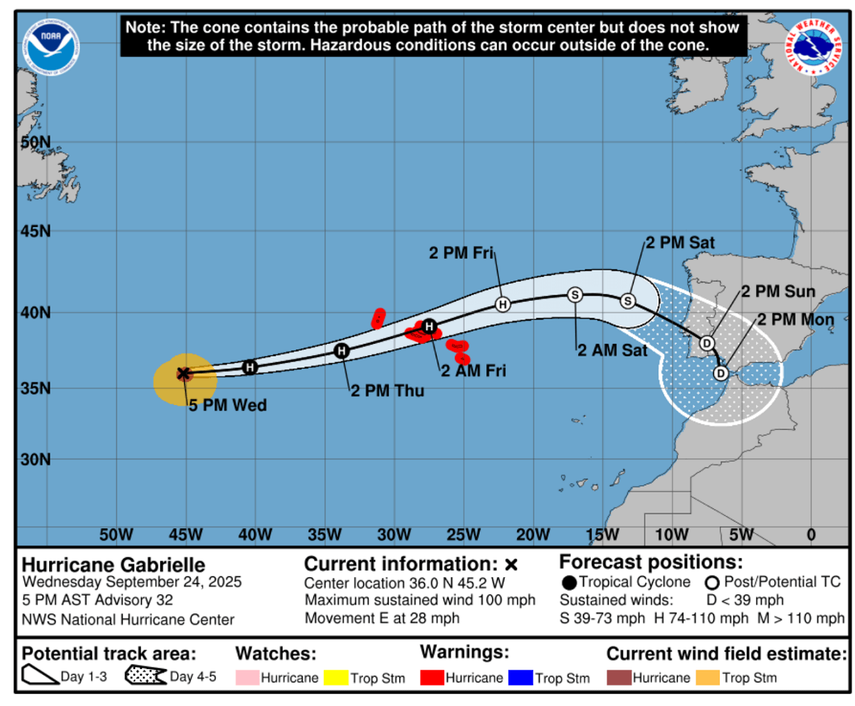
The National Hurricane Center (NHC) forecast track brings Gabrielle across the Azores Thursday night into Friday morning. Hurricane warnings are in effect for the archipelago. A powerful wind and storm surge blast is forecast.
After the Azores passage, Gabrielle will track further east and gradually transition into a post-tropical storm, maintaining hurricane strength until Friday evening. Then, it will hold tropical-storm-force intensity until its landfall in Portugal on Saturday.
A close-up of the Azores on Thursday night reveals that powerful winds will impact the islands, although it is still uncertain where exactly the hurricane’s core will travel. Note that the most violent winds and intense rainfall are associated with the storms near the center low, while tropical-storm-force winds are spread further out of the core.
High-resolution models hint that the peak wind gusts could be from 160-200 km/h when hurricane Gabrielle passes over the Azores Thursday night into early Friday morning. The elevations above 1000 meters above sea level will experience even higher gusts, above 200 km/h or even 250+ km/h.

The peak wind swath forecast across the archipelago indicates how narrow the most intense winds will be, less than 50 km across. So it all depends on where the core of Gabrielle will travel. While the impact on most of the Azores will be felt, only a narrow swath will experience the most violent winds.
The following ICON weather model swath indicated the most impactful area will be across the northern portion of the Azores, while GFS and the ECMWF models hint the path could be a bit further south. Nonetheless, the widespread impact is forecast, and people are advised to be prepared and follow the local warnings and advisories.

According to the IPMA weather office forecast for the Azores, adverse weather conditions are expected, especially in the Western and Central Groups. In the Western Group, rainfall will be intense, and winds with gusts up to 150 km/h from the south will blow north. An offshore turmoil will occur with significant wave heights between 8 and 10 meters, with the maximum wave reaching 14 to 18 meters.
In the Central Group, there will be occasional heavy rain squalls, gusty winds as high as 200 km/h from the south to northwest, and offshore turbulence with waves between 8 and 10 meters in height. The maximum waves could reach 14 to 18 meters.
The Eastern Group is expected to be the least affected, with occasional heavy rainfall, wind gusts up to 90 km/h, and ripples ranging from 6 to 7 meters in height, which is significant.
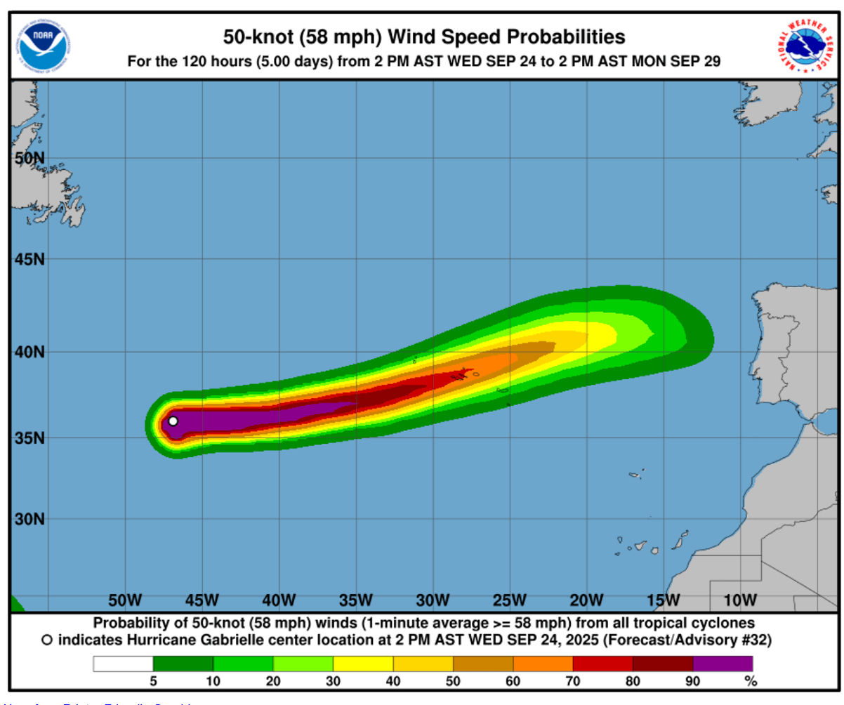
The following chart by NHC shows how far east the tropical-storm-force winds (50 knots) will reach. There’s a 70-80 percent probability of this significant impact on the Azores, while a 30-50 % chance extends further east, just a few hundred kilometers from Portugal’s western coast.
Gabrielle transforms into a post-tropical storm on Friday, heads for Portugal landfall
Towards Friday afternoon, hurricane Gabrielle will continue east while ingesting much cooler sea waters underneath. Thus, it will transition into a post-tropical storm but maintain a hurricane-force wind intensity until evening, when gradually weaker winds will follow.
By Saturday midday, ex-Gabrielle nears the central west part of Portugal, with a closed low surrounded by a building up Azoric High ridge to its west. After landfall, the land interaction will also help the storm to weaken its strength late Saturday rapidly.

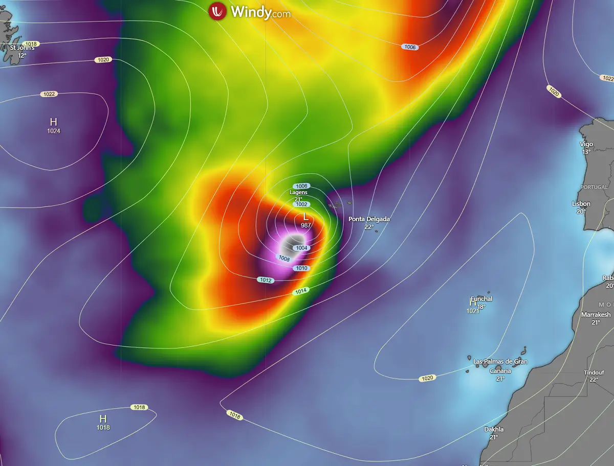
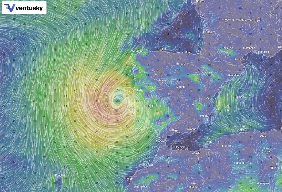
This is the close-up view by the high-resolution ICON weather model around midday Saturday, with the post-tropical low centered west of Lisbon, Portugal.
Surrounded by winds up to 100 km/h, high waves will spread towards the coastal areas.
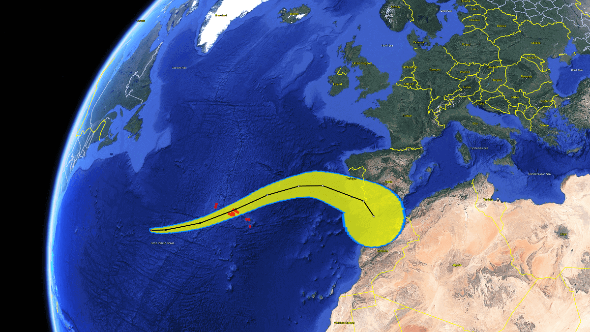
So, the complete swath of Hurricane Gabrielle will be pretty impressive for the region. Although these impacts happen occasionally, being well-prepared for Gabrielle’s impact is advised. Coming after its peak intensity as a major hurricane, the system is approaching fast, and the wind and storm surge blasts could be violent.
The following chart indicates the swath of the most intense winds from Thursday morning until Sunday.

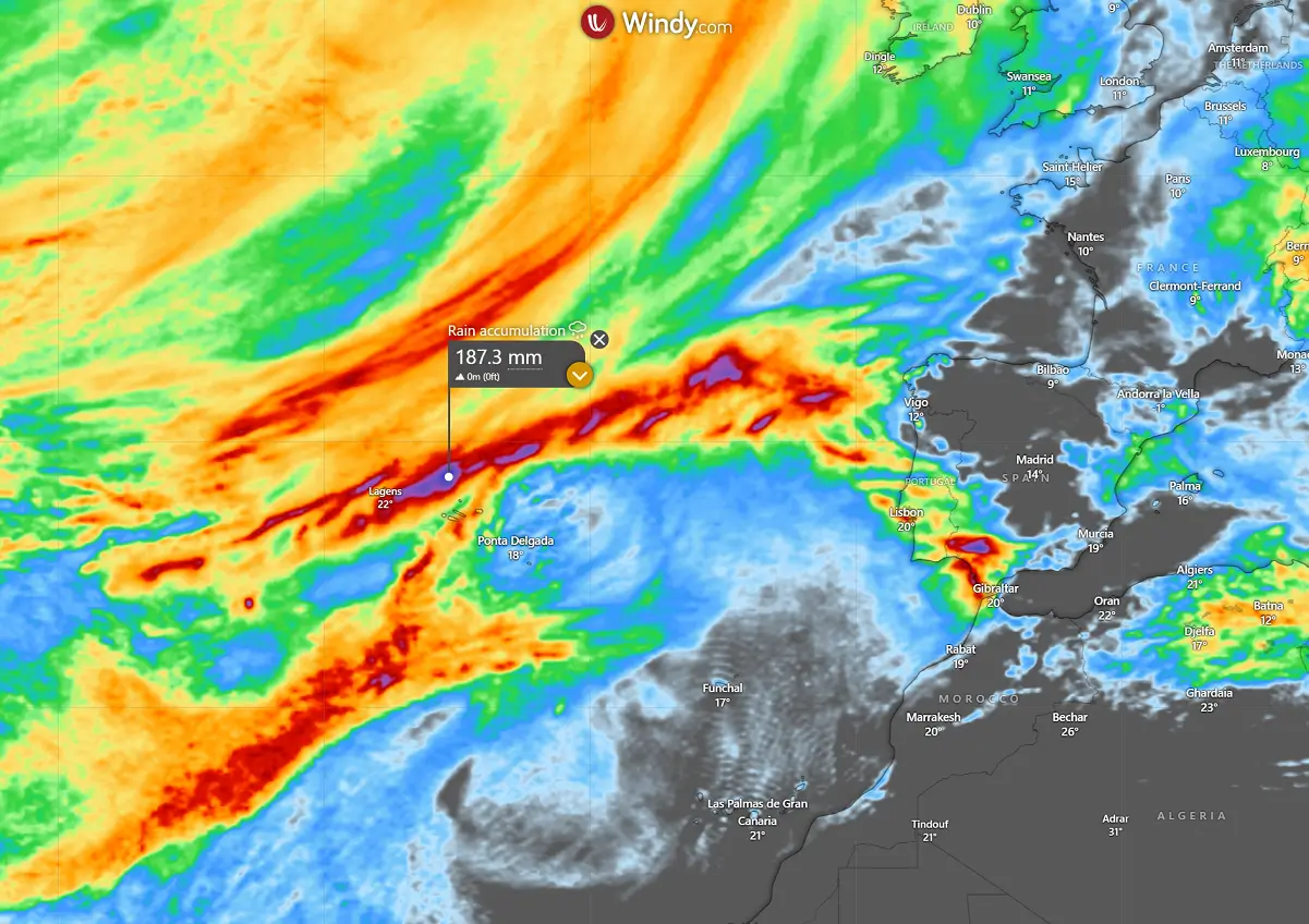
As usual, the most intense storms surround the hurricane’s core, and the most robust rainfall is closely connected to these storms. The rain accumulation chart below shows these storms and rainfall amounts, with 150-200 mm possible across the Western Group in the Azores.
The storm’s track swath then continues east-north and curves southeast towards southern Portugal, related to the forecasted track of the ex-Gabrielle’s core from Friday into Saturday.
Stay alert for dangerous weather conditions and follow updates on the warnings from your local meteorological agency, IPMA Portugal.
Windy, Ventusky, and Tropical Tidbits provided images used in this article.
See also: