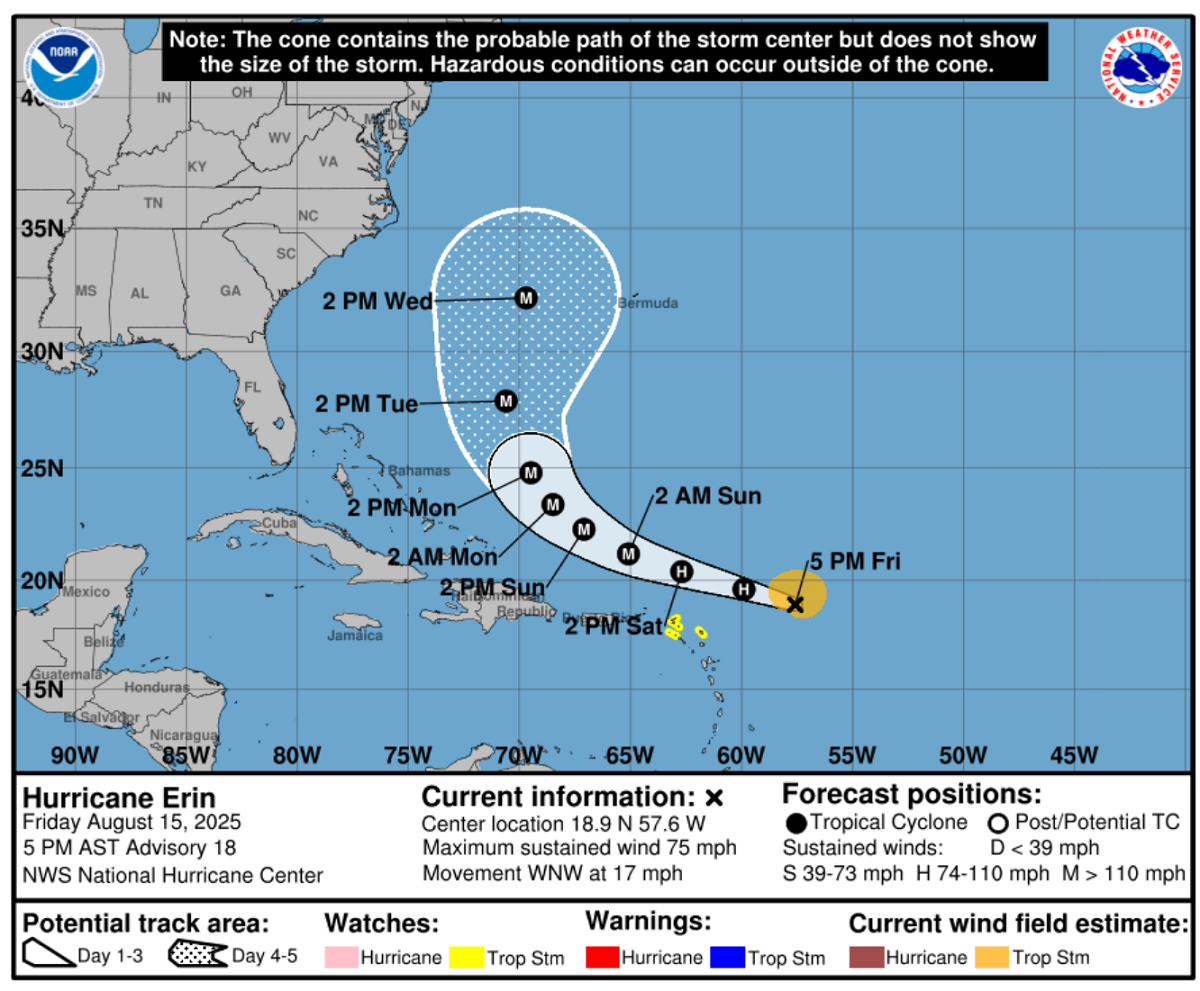
The North Atlantic has churned up the first hurricane of the 2025 hurricane season, Erin, which forms in the central tropics as it moves west. Over the weekend, Erin will continue to intensify as it approaches the Leeward Islands and Puerto Rico, becoming a powerful Atlantic storm. Latest model guidance suggests Erin will track between Bermuda and the U.S. East Coast next week.
While tracking west, Hurricane Erin will move close enough to Puerto Rico to develop heavy rainfall, strong winds, and surf conditions. The storm is in favorable, warm Atlantic Ocean waters, supporting its rapid strengthening into a major hurricane in the coming days.
Note: On average, the first Atlantic hurricane formation is August 11th.
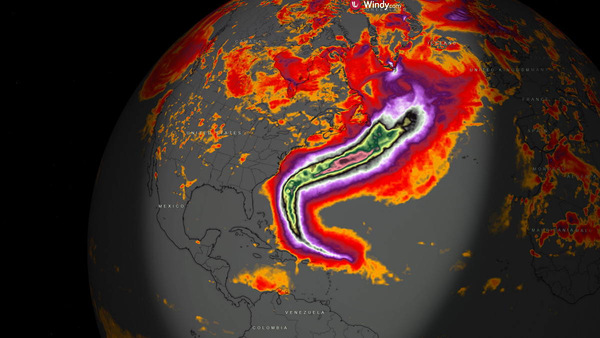
Erin is forecast to become a major hurricane (Category 3 or greater) by no later than Sunday morning and gradually turn its track from west into northwest early next week, then due north after Tuesday.
The following video reveals a rapidly organizing and strengthening hurricane Erin, tracking west towards the Leeward Islands Friday night.
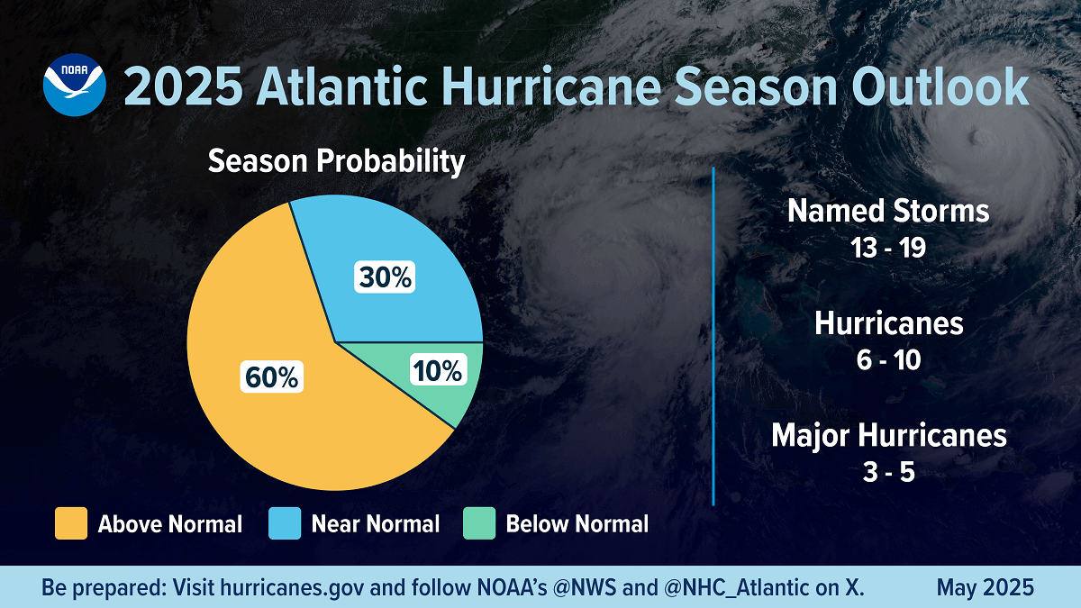
Before we get into further details, here are quick notes on the approaching peak of the 2025 hurricane season. NOAA predicts a 60 percent chance of an above-normal 2025 Atlantic hurricane season.
NOAA is forecasting 13 to 19 named tropical storms this year, with 6 to 10 of those becoming hurricanes. The agency also predicts 3 to 5 hurricanes could reach major strength (Category 3 or greater).
Global weather is a very complex system of chaos theory, and weather dynamics and patterns are also very different worldwide. Furthermore, tropical dynamics are one of the more complicated things, involving many factors to produce a combination of winds, pressure, and temperature, resulting in dangerous tropical weather threats for land and property.
During an average tropical year, the Atlantic hurricane season produces up to 14 named tropical storms. On average, seven typically become hurricanes, with around 3 reaching major strength.
A typical Atlantic hurricane season has two peaks.
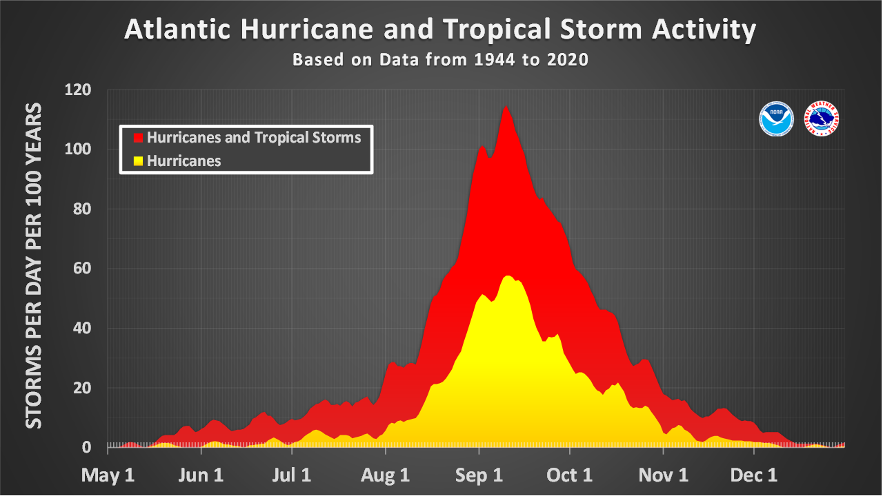
The first period of increased activity occurs from early through mid-September, while the second boost typically happens through mid-October. Statistically, the general increase in activity across the tropical Atlantic generally begins in the trough early/mid-August.
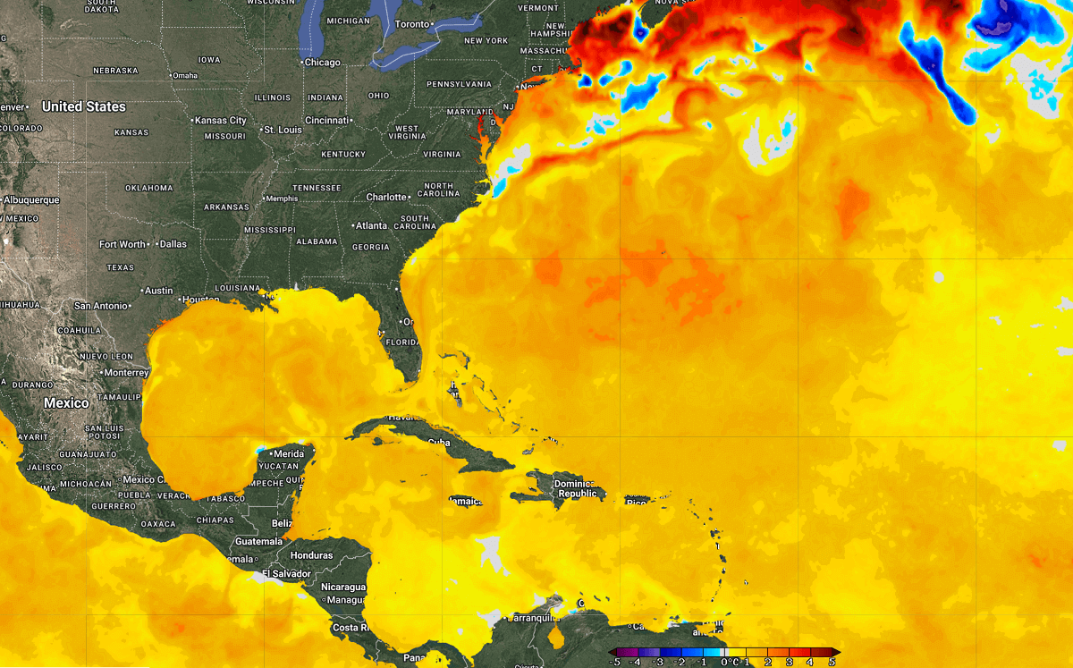
Much warmer-than-average temperatures over the North Atlantic Basin, Caribbean, and Gulf of America
Global sea temperatures have generally warmed in recent years, with marine heat waves becoming more frequent and intense. This year, they are more persistent and spread over large areas, aligned with the global overheating climate and seas. It is hard work to find near-normal or colder spots of the Atlantic this year.
Sea temperatures across the Caribbean, especially the Gulf of America and the Bahamas, are extremely hot, 30-32 °C across a large part of the region. This is becoming a significant concern for potential storms that will track into this source of high ocean heat during the peak of the hurricane season in September and October.
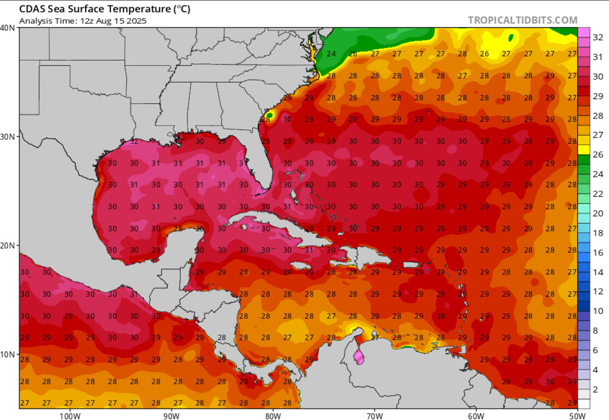
The tropical central and western Atlantic regions remain well above normal as we enter the final month of meteorological summer 2025. As of mid-August 2025, most of the Atlantic Basin had temperatures 1-4 °C above normal, which correlates well with what is typically seen before the active Atlantic hurricane season.
Similar conditions are observed over the MDR region (main development region), where more tropical cyclones form and track towards the Caribbean and the U.S. mainland.
The near-term SST anomaly forecast also hints that temperatures will remain very high through the fall months. We expect the North Atlantic’s sea waters to be sufficiently warm to support significant tropical development during the peak of the hurricane season from late August into September this year.
During the summer months, we closely monitor Western Africa’s weather conditions. This is where the tropical waves emerge into the eastern Atlantic Ocean. Data shows that nearly 85% of these waves lead to organized deep convection over the warmer oceans and become tropical depressions or storms.
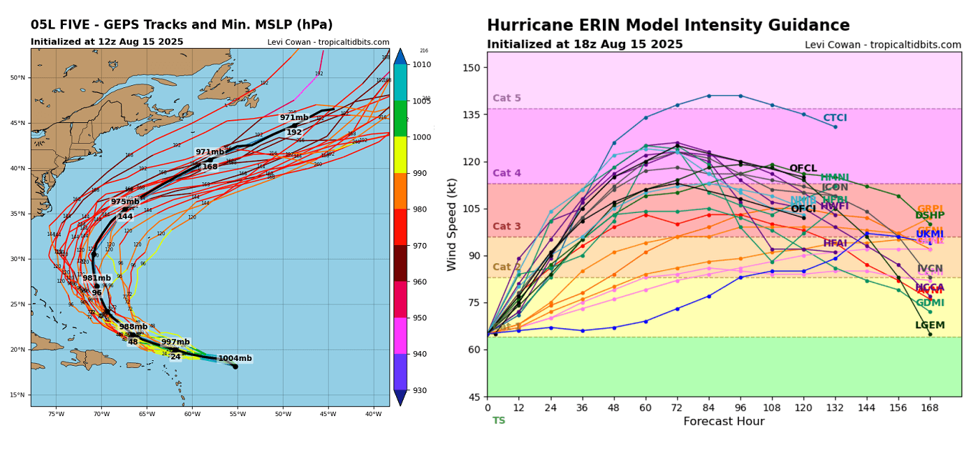
Hurricane Erin is forecast to become Category 3 by Sunday, then continue strengthening further next week
The latest weather model guidance and NHC NOAA bring Hurricane Erin tracking west to the north of the Leeward Islands and Puerto Rico on Saturday and Sunday, gradually turning towards northwest and reaching major strength.
By late Monday and early Tuesday, Erin takes a more northerly track while grazing across the warm waters and favorable conditions to maintain its strength and likely further intensify.
General weather model predictions agree that hurricane Erin will be at least a strong Category 3 by late Sunday and possibly a powerful storm with Category 4 strength. This is supported mainly by favorable oceanic conditions with hot water underneath the storm.
While hurricanes’ exact peak intensity is still hard to predict, recent years have shown that similar extremely hot and anomalous sea water temperatures tend to bring more intense storms than initially anticipated. We may also see a high-end Category 4 by late Tuesday and Wednesday or even a Category 5.
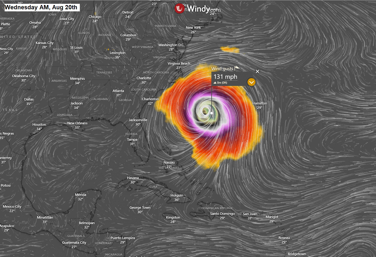
The Wednesday morning wind forecast is attached. Wind gusts peak around 130 mph, a solid Category 3 storm intensity. The wind field of Erin will be huge, so expect large rip currents to affect the U.S. East Coast mid-week.
From Tuesday through Friday, Erin will be moving due north between the U.S. East Coast and Bermuda, before it starts its accelerating phase and more northeast track late next week.
However, based on recent predictions, Hurricane Erin will remain over open water throughout its life cycle and is not forecast to make landfall anywhere in the Caribbean, U.S. mainland, or Canada.
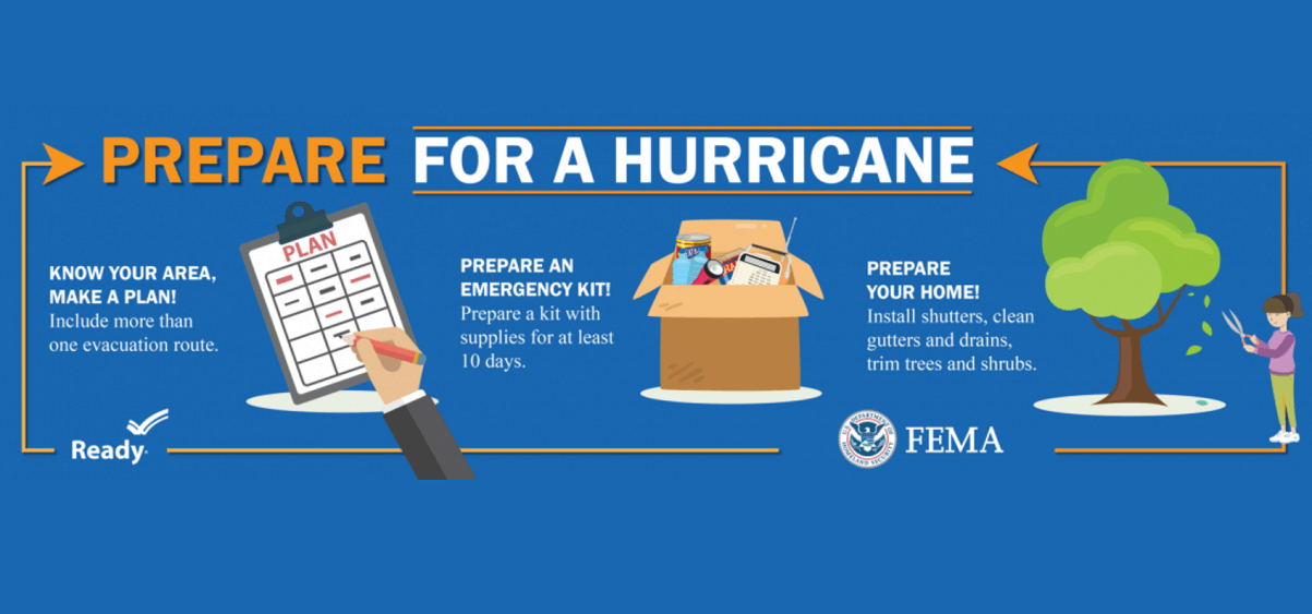
Safety Preparedness during a Hurricane Season

Have a plan
The official hurricane season in the North Atlantic and the Caribbean starts on June 1st and ends on November 30th. This is when you and your family must be prepared by planning.
- Write emergency phone numbers and keep them on the refrigerator or near every phone in your house. It would help if you also programmed them into your cell phone.
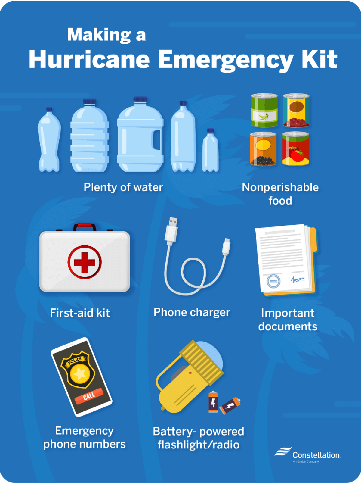
- Prepare an emergency supply kit.
- Locate the nearest shelter in your area and different routes from your home in an emergency. If shelter locations in your area have yet to be identified, learn how to find them before the event of a storm.
- Pet owners: Take care of your pets at pre-identified shelters, a pet-friendly hotel, or an out-of-town friend or relative where you can take your pets in case of an evacuation. Local animal shelters can offer advice on what to do with your pets if you are asked to evacuate your home during a hurricane.
Learn the difference between a hurricane “Watch” and “Warning”
When you listen to the National Weather Service alerts on TV or radio or check for them online, there are two kinds of alerts:
- A hurricane watch means hurricane conditions (sustained winds of 74 miles per hour [mph] or higher) are possible in a stated area. The National Hurricane Center (NHC) will announce hurricane watches 48 hours before it expects tropical storm-force winds (sustained winds of 39 to 73 mph) to start.
- A hurricane warning is a more severe threat. This means that hurricane-force winds are expected in a stated area. NHC issued these warnings 36 hours before tropical-storm-force winds were expected in the area to give people enough time to prepare for the storm.
Check out the National Weather Service’s Hurricane Center for more information about hurricane watches and warnings. If you hear a hurricane watch or warning in your area, you can take steps to get ready.
Get your car ready to leave home if needed
Make sure your car is ready before the tropical storm or hurricane hits.
- Fill the gas in your car’s tank.
- Move cars and trucks into your garage or under cover.
- Always keep an emergency kit in your car.
If you don’t own a car, consider making plans with friends and family or calling the authorities to get a ride if you need to evacuate.
Get your family and pets ready
- Go over your emergency plan with your family; understand everything.
- Keep checking for weather updates about the storm. You can watch TV, listen to the radio, or check the NHC website online.
- Call the hospital, public health department, or the police about special needs. If you or a loved one is older or disabled and won’t be able to leave quickly, get their advice on what to do.
- Put pets and farm animals in a safe place.
Get your home ready
- Clear your yard to ensure nothing can blow around during the storm and damage your home. Move bikes, lawn furniture, grills, propane tanks, and building materials inside or under the shelter.
- Cover up house windows and doors. Use storm shutters or nail pieces of plywood to the outside window frames to protect your windows. This can help keep you safe from flying debris and pieces of shattered glass.
- Be ready to turn off your power if you see flooding, downed power lines, or have to leave your home. Switch your power off completely.
- If you lose your water supply during the storm, clean containers with drinking water. You can also fill your sinks and bathtubs with water for washing.
- Double-check your carbon monoxide (CO) detector’s battery to prevent CO poisoning.
Be ready to evacuate or stay at home
During a hurricane warning, always listen to authorities regarding whether you should evacuate or stay home.
If a hurricane is coming, you may hear an order from authorities to evacuate (leave your home). Never ignore an order to evacuate. Sturdy, well-built houses may not hold up against a hurricane’s power. Staying home to protect your property is not worth risking your family’s health and safety.
There are occasions when you may hear an order to stay at home. If driving conditions are too dangerous, staying home might be safer than leaving. Respect the authorities’ decisions.
If you need to evacuate:
- Grab your emergency supply kit and only take what you need (cell phone, chargers, medicines, identification like a passport or license, and cash).
- Unplug your appliances. If you have enough time, turn off the gas, electricity, and water.
- Follow the roads emergency workers recommend, even if dense traffic is expected. Other routes might be blocked or already flooded. Never drive through flooded areas, as cars and other vehicles can be swept away or may stall in just 6 inches of moving water.
- Contact your local emergency management office and ask if they offer accommodations for owners and pets.
If you need to stay home:
- Keep your emergency supply kit somewhere you can easily access it anytime.
- Follow weather updates online from NHC, and listen to the radio or TV for updates on the hurricane.
- Stay inside. Even if it looks calm, don’t go outside. Wait until you hear an official message that the hurricane is over. Sometimes, the weather gets calm in the middle of a storm, but then quickly worsens again.
- Stay away from windows. You could get hurt by flying debris, such as pieces of broken glass or other objects picked up by the winds around the neighborhood during the storm. Stay in a room without windows or go inside a closet.
- Be ready to leave home. If emergency authorities order you to leave or your home is severely damaged, you may need to go to a shelter or a neighbor’s house.
Our expert forecaster team will actively follow the tropical region activity worldwide, including Atlantic Basin systems and tropical cyclones likely to affect the United States, the Caribbean, and Europe again in the following months.
Stay tuned for further follow-up posts, in-depth forecast discussions, and nowcasting during the coming weeks and the upcoming Atlantic hurricane season 2025 peak months. We will prepare you.
NOAA, NHC, Colorado State University, and WHO provided images used in this article.
See also:
La Niña Watch is issued by NOAA as Pacific Cools, with a major reversal now looming for 2026