A new Heat Dome is forecast to develop across the United States and Canada for the remainder of July 2025, bringing more stable, hot, and dry weather conditions. First, the eastern two-thirds of the country will be affected early next week, then the sweltering hot weather will intensify and expand the heatwave further west and north into Canada.
While July is typical across the central United States, more stable weather patterns will soon replace sweltering hot and severe weather. Next week, the weather models agree that a significant change is coming as a powerful and long-lasting Heat Dome returns.
A major Heat Dome will first build up into the central and eastern U.S. by early next week, gradually expanding north and west across the nation throughout the week and continuing into the final days of July.
Temperatures will significantly increase, and combined with high humidity, this will lead to sweltering hot weather with an extremely high Heat Index.

The following video animation shares an overview of the changing and developing general weather patterns across the Contiguous United States and Canada through the end of July 2025.
We can notice how an upper-level blocking High will dominate the eastern two-thirds of the country first, then expand into western CONUS and southern Canada late next week. This means a more stable and sweltering hot weather is forecast.
The heat will spread across much of the country and become significant next week, particularly across the northern U.S., the Upper Midwest, and the Great Lakes.
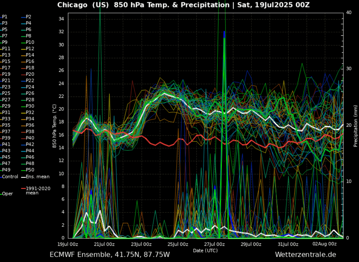
The attached meteogram for Chicago, IL, over the following 14 days reveals that rapid warming is forecast underneath the new Heat Dome after the ongoing near-average conditions.
Temperatures will push much higher throughout the atmosphere, meaning a significant blocking ridge (High) will occur. Thus, a much warmer weather period with excessive heat will develop.
So, the upcoming heatwave will be intense and occur with the establishment of a Heat Dome aloft. Let’s examine this large-scale feature.
What is a Heat Dome?
When significant and historic record-breaking heatwaves occurred in Europe, the United States, and Canada in the past, the Heat Dome was a contributing factor. The heat dome is usually the dominant feature of summer weather patterns on both continents.
We refer to this phenomenon as a heat dome when extremely high temperatures develop. Here’s how it works and why understanding it on a broader scale is essential.
The upper-level ridge pattern, or very warm air mass in the higher altitudes, also known as the Upper High (or blocking High), usually forms the heat dome. This weather pattern brings high and sometimes record-breaking temperatures to the region underneath.
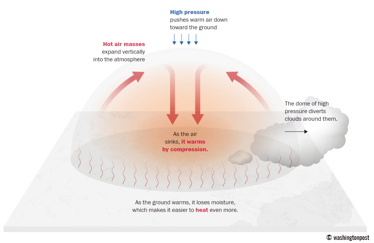
This term is used when a broad area of high-pressure air parks over a large portion of the continent. If the event is remarkably stable and extreme, it usually lasts several days or weeks.
The heat dome works like a lid on a pot. The extensive dome traps warm air at all levels underneath, with layers sinking toward the ground. Therefore, the air mass becomes anomalously warm at the lowest elevations and extremely hot near the surface.
How does it impact the life underneath?
Excessive heat in heat domes can significantly impact human health and be dangerous to particularly vulnerable populations, such as elderly individuals, children, and those with pre-existing health conditions that can be worsened by extreme heat.
Due to prolonged exposure to high temperatures, construction workers, farmers, and agricultural workers who work outdoors for long hours are at increased risk of heat-related illnesses. People living in poverty are also more susceptible to the fatalities of heat domes, as their houses are often built with heat-trapping surfaces such as concrete and asbestos.
Heat exhaustion occurs upon exposure to high temperatures for extended periods. It leads to dehydration, dizziness, and, in more severe cases, heat exhaustion can progress to heat stroke.
High relative humidity during a heatwave can also significantly affect the body. For this reason, we use a Heat Index to represent the natural feel of scorching hot temperatures and high humidity. These graphics illustrate the natural relationship between temperature and humidity.
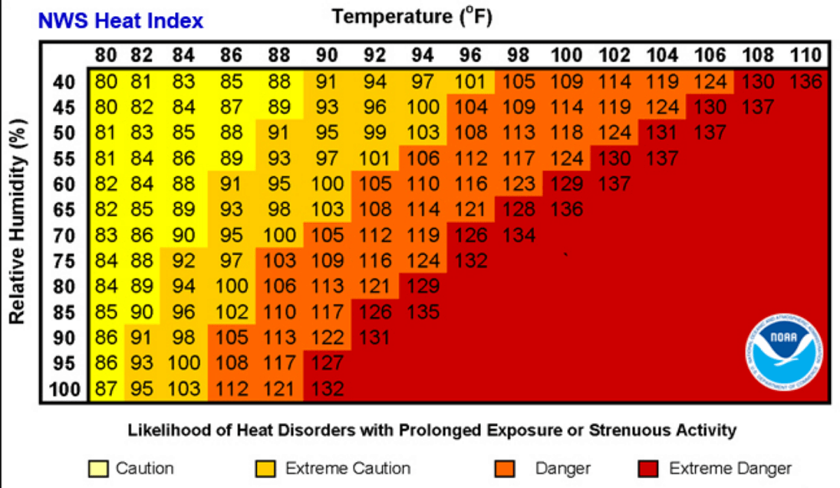
As we can see, when the air mass has a temperature around 90°F, humidity below 60 percent is much less challenging than when the humidity is very high, e.g., above 80%. Thus, the actual feel temperature would be near 113 degrees F.
Heat waves have also been associated with increased rates of heart attacks, strokes, and respiratory illnesses.
For further details on the health risks, please refer to our additional article “Health Risks during a Heatwave and Sweltering Hot Weather”.
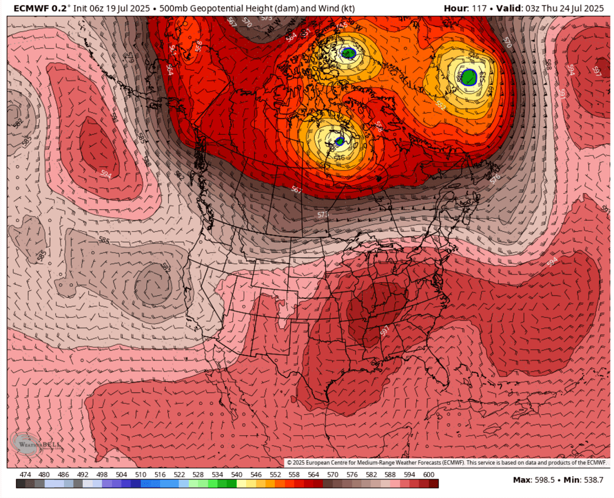
A new upper ridge expands over the east-central U.S., intensifying the Heat Dome and heatwave next week
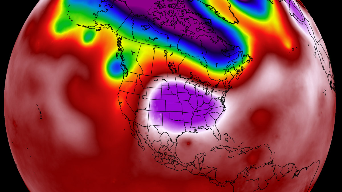
The general weather picture over the Contiguous U.S. for early to mid-next week indicates a typical dipole weather pattern. An upper wave/low is emerging into the western U.S., and a broad area of high pressure is forecast to its east, gradually developing beneath the upper ridge.
At the same time, a Heat Dome begins forming aloft, stabilizing the ridge and strengthening its core even further. This traps a much warmer air mass underneath, leading to increased sweltering hot conditions and high humidity.
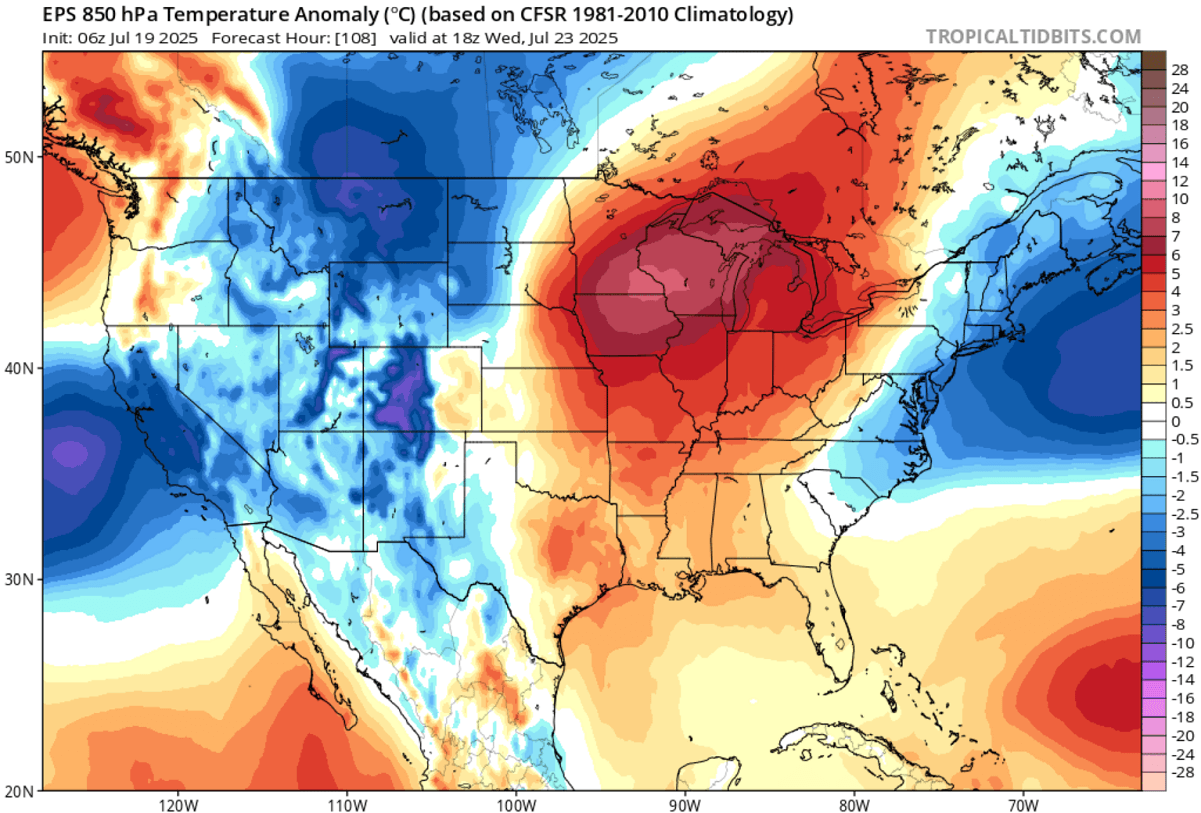
By early next week, the warmest air mass will first spread across the southern and central U.S. into the Midwest, with the highest anomalies reaching around 10 °C above normal at the 850 mbar level. With the strengthening Heat Dome aloft throughout the week, the air mass becomes even warmer and anomalous into the Upper Midwest and Great Lakes after mid-week.
The 5-day temperature anomaly is attached below, indicating where the hottest air mass will develop next week.
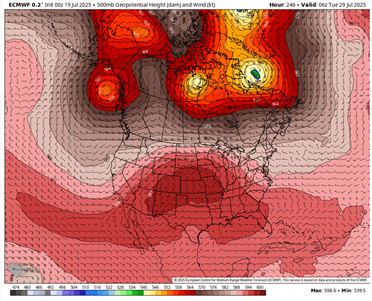
The following weather pattern chart hints at the major country’s dominance of the blocking High after Monday. Centered over the Great Lakes and the Upper Midwest. The upper blocking High and ridge will mature across the eastern two-thirds of the country, with excessive hot weather trapped underneath the heat dome.
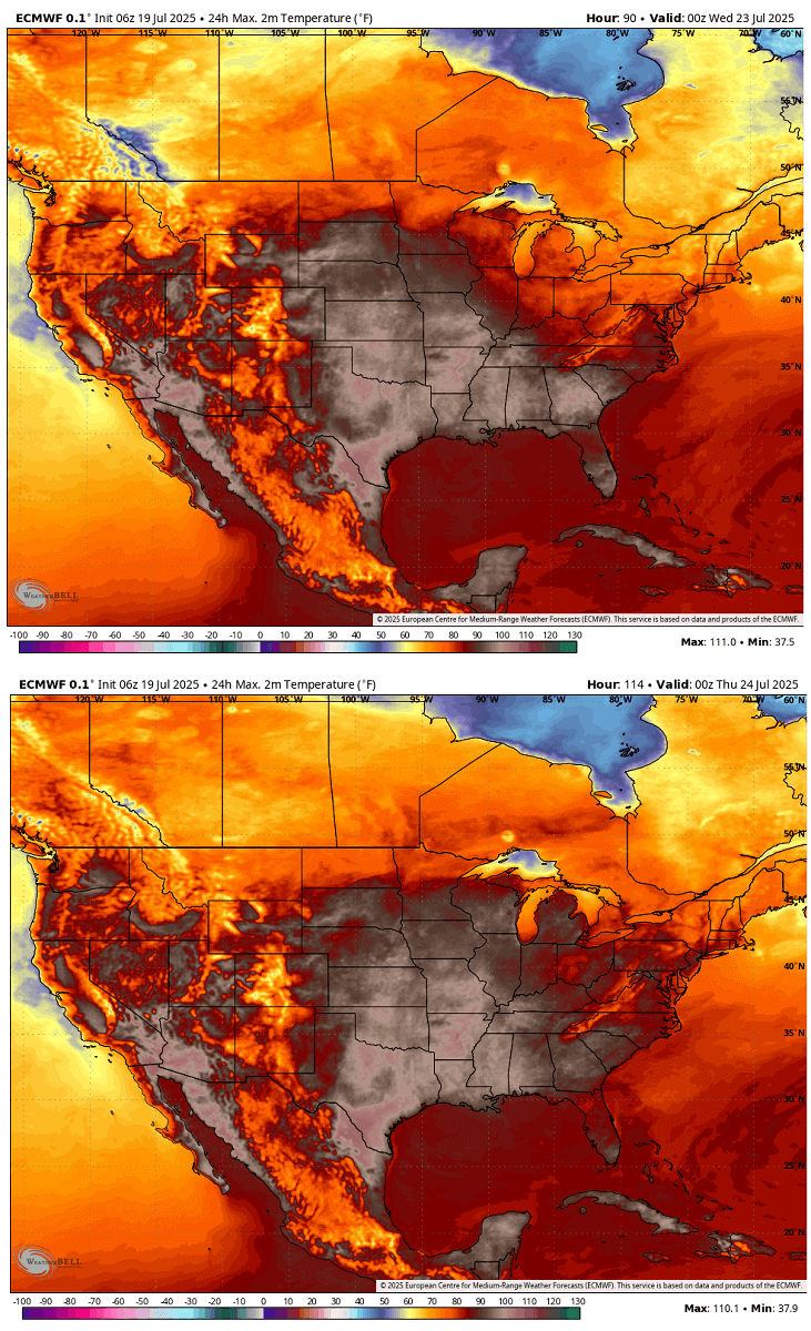
This translates into significantly warmer days at the surface, with temperatures already pushing above 100°F for many after Monday. Those will continue increasing throughout the week as the Heat Dome aloft matures.
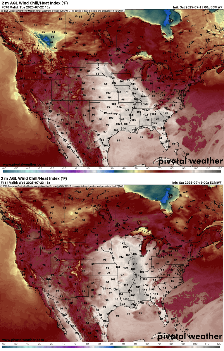
After multiple rounds of fronts and storms through May, June, and recently, an above-normal amount of rainfall has been observed across the central, south, and eastern parts of the United States. With the arrival of hot summer weather, hot temperatures also introduce significant evapotranspiration from the crops, combined with moist air mass advected from the Gulf.
Thus, this leads to extremely high Heat Index values nationwide, a mixture of high temperatures and high relative humidity.
As we see on the following chart for Wednesday and Thursday, upper 90s to around 110°F will develop across a large part of the country. The most extreme values are across the Mississippi, the Midwest, the Upper Midwest, and the Great Lakes, where the highest moisture is present.
The Mississippi River and Ohio Valley will experience excessive heat as the blocking High aloft parks over the region for days. The air mass underneath will be ‘overheating’, typical during intense Heat Dome events.
Very hot weather is forecast to continue the following weekend, potentially expanding north and west and lasting further.
After the following week’s pattern, the general trends in global weather models also indicate that the heat dome will likely maintain its strength and continue through the remainder of July. A gradual expansion towards southern Canada and the western United States is also forecast, causing excessive heat in most countries.
We will continue to monitor the evolution of the weather pattern and update the forecasts accordingly. Stay tuned.
Pivotalweather, Wxcharts, WeatherBell, and Wetterzentrale provided images for use in this article.
See also: