What has been forecast on the weather charts is a high probability of a powerful heatwave that will develop into southwestern Europe first, then gradually spread into western Europe this week. A strong and persistent heat dome will take place across France and Spain. The upcoming heatwave is following soon after the extremely hot and dry May 2022. It was the hottest May on record for much of southwestern Europe and northwestern Africa countries.
The extreme heat has already been intensifying across the Iberian peninsula this weekend, where Spain, Portugal, Morocco, and Algeria have experienced low 40s during the peak afternoon hours. The heat will also spread north-northeast into France in the coming days and intensify more.
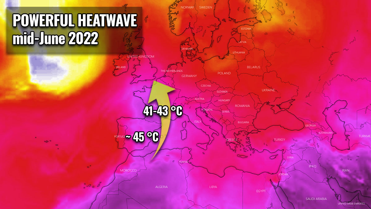
Temperatures are forecast to rise into the low to mid-40 °C across south-central France, even higher across Spain where they could exceed 45 °C. Both countries could be challenging some historic heat records for the month of June. These will be *extremely* high temperatures for western and southwestern Europe for the first half and mid-June.
Aside note: The all-time heat record in Spain has been set on June 27th, 1965 when the temperature peaked at an astonishing 45.2 °C.
Attached below is the quick video animation of the developing heat dome and a strengthening heatwave from southwestern into western Europe. Becoming particularly intense and anomalous over Spain, Portugal, and France.
Some of the heat also reaches Germany, Benelux, and England later this week and could potentially extend into next week.
WHAT IS A HEAT DOME AND WHY DOES IT BRING INTENSE HEAT?
Let’s first quickly go through the primary background cause of the upcoming intense heatwave. We have already heard the term heat dome in the past, no matter if you live in Europe or in the United States. In 2021 for example, it was the dominant feature of summer weather patterns on both continents.
Heat dome will be the term we will use when extremely high temperature develops, here is why.
The upper-level ridge, which we know as the blocking High pattern, normally forms a so-called heat dome. This weather pattern brings often very high, sometimes record-challenging temperatures for the region affected underneath. A heat dome is a term that we use when a broad area of high-pressure parks over a large portion of the continent. It usually stays there for several consecutive days or even weeks.
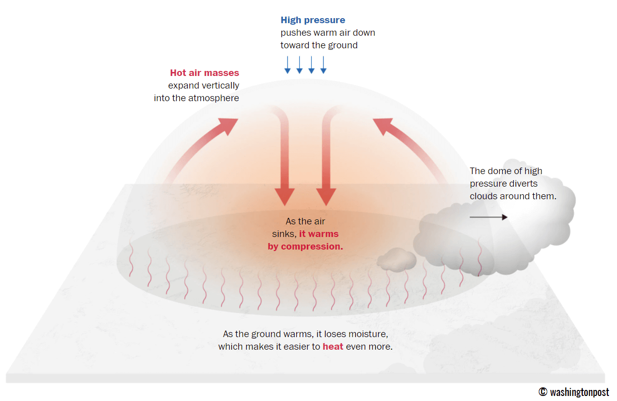
The simple explanation we could use when debating about the heat dome is that it works like a lid on a pot. The large dome results in the trapping of a very warm air mass at all levels underneath, particularly at the lowest elevations. Thus it is creating very stable weather and often also very dry air mass with minimal chances for precipitation, or even clouds. Resulting in rising temperatures into extreme values, thanks to sinking air parcels in the center of the heat dome.
Typically, extreme heat is its result which leads also to a significantly enhanced wildfire threat due to developing drought or even worsening the ongoing, pre-existing very dry conditions. Therefore, heat dome is often also to blame for being responsible for deadly heatwaves around the world.
The daily maximum temperature, and average temperatures in particular, under the heat dome, are typically well above normal. They often challenge or even break the existing, historic records. Especially if the heat dome develops during early summer or early autumn/fall season.
POWERFUL HEATWAVE GRADUALLY DEVELOPING OVER SPAIN AND PORTUGAL, TEMPERATURE TOWARDS 45 °C
This week, a developing blocking weather pattern across west-southwestern Europe is forecast to be a part of the newly developed heat dome. The heatwave underneath is expected to extend across many countries and last for at least 5-7 days, possibly even longer across southern France and the Iberian peninsula.

Therefore, the weather situation is favorable for a significant increase in temperatures across the Iberian Peninsula first. What makes this pattern develop this way is a cold drop (known as upper low) gradually isolating itself over the Azores and sliding towards the Iberian peninsula. This leads to the establishment of a particularly hot southerly flow from northwestern Africa into Spain and Portugal.
The southwesterly flow in the upper levels will be advecting hot and dry airmass directly from the desert areas of Morocco and western Algeria. We know this pattern as the “Spain plume”.
As a result, temperatures are in a rather rapid increase at the lowest levels of the atmosphere this past weekend and will gradually further intensify into the new week. The temperature is forecast to be reaching more than 28 °C at the 850 mbar pressure level. This is extremely high for the mid-summer period, thus making this heatwave quite exceptional for the first half of June.
The strengthening heat dome is resulting in the first powerful heatwave of the year 2022, with scorching heat over the Iberian Peninsula these days. Especially southern Spain and Portugal have prone areas for very high temperatures in the past, and it will be rather similar this week.
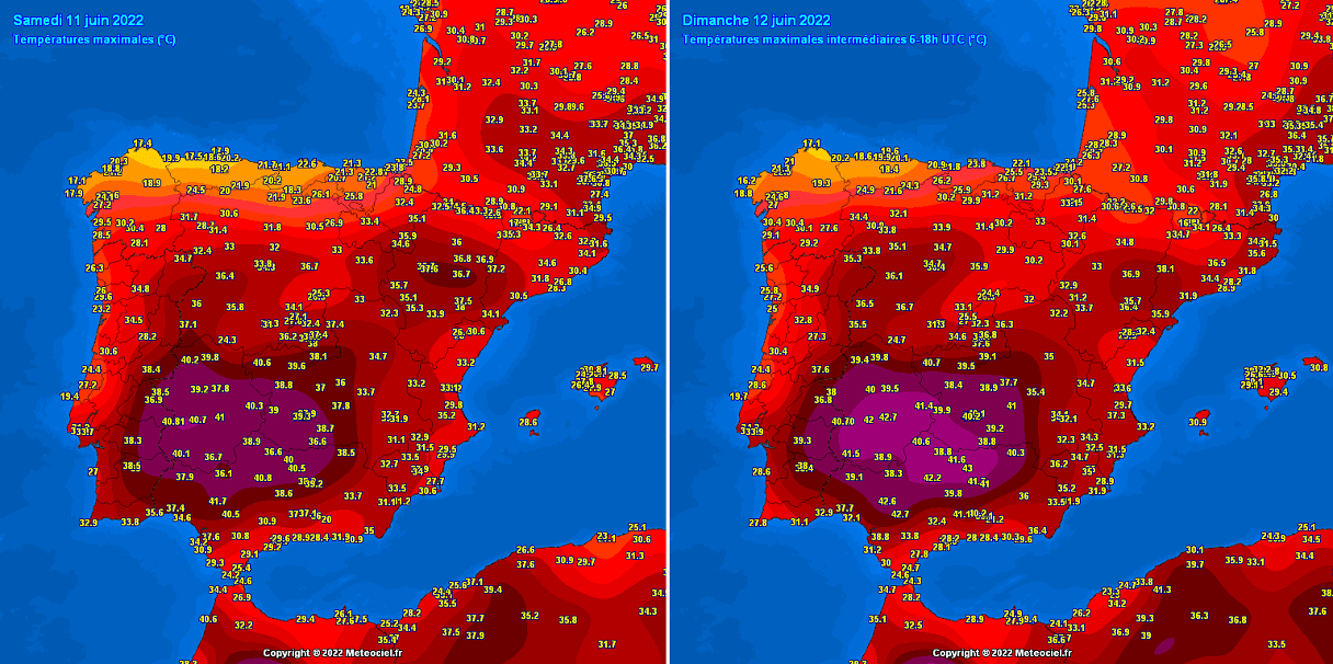
In recent days, scorching heat has already been reported. This Sunday brought 43.0 °C in Andajor, 42.7 °C in Moron de la Frontera, and 42.2 °C in Sevilla, Spain. The below charts are showing the highest temperatures on Saturday and Sunday.
Temperatures are forecast to be even higher in the coming days when the most extreme values of this heatwave are expected. Temperatures across parts of Spain and Portugal could exceed 42-43 °C in the southern regions. Even higher daytime peak temperatures are locally possible, reaching from 44-45 °C between Monday and Thursday. Thus challenging June’s record of 45.2 °C in Seville, Spain.
These temperatures are exceptional for the early-mid June period in southern Iberia. Attached below is the peak temperature forecast for Monday (left) and Wednesday (right chart) across southwestern Europe. The GFS model hints at not far from the 45 °C mark in the southwestern part of Spain.
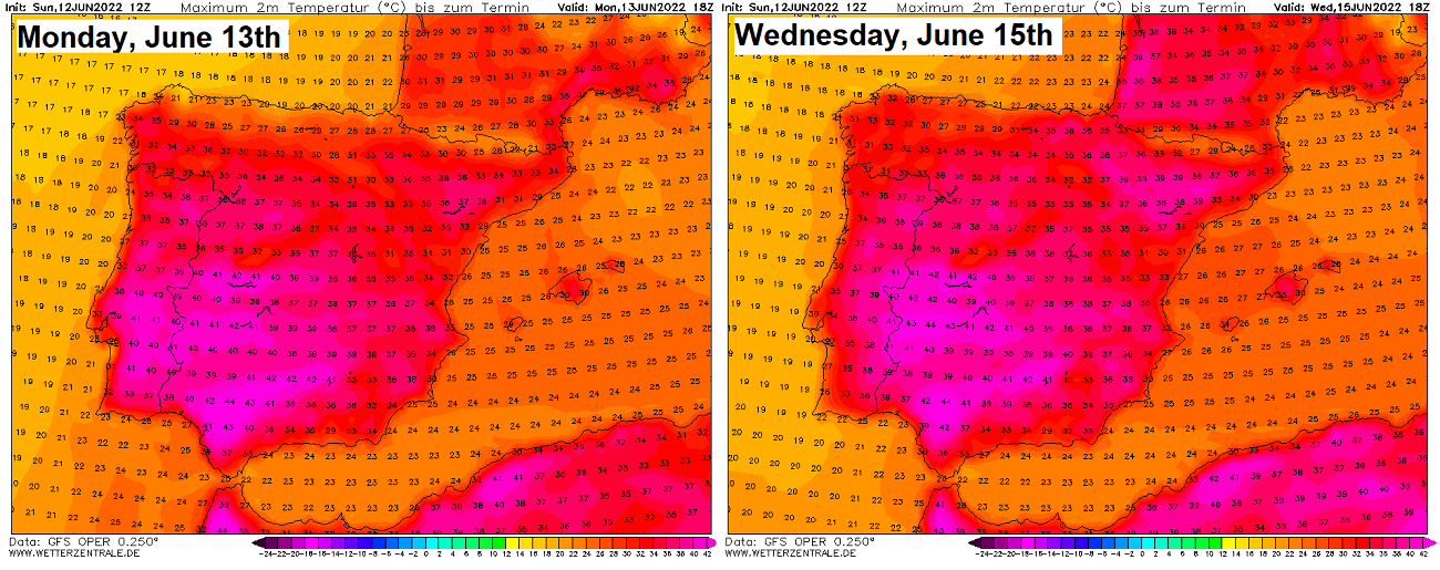
Note, that the national heat record in Spain is held by the city of Montoro from August 2021 when the scorching heat of 47.4 °C has been recorded. The values forecasted in the next few days could well approach the record values for June.
HEAT DOME EXPANDS INTO FRANCE, HEATWAVE SIGNIFICANTLY INTENSIFIES
As the general weather pattern stays pretty similar also into the mid-this week, the heat dome and heatwave underneath will also spread farther north and northeast into France, Swiss, and the western Alps. Also towards western Germany, Benelux, and England towards the next weekend.
The most intense heat is, however, expected for southern Spain, but the strengthening upper High over France will rise temperatures into the low 40s there as well.
With the upper wave sitting over northwestern Iberia, the very warm airmass will easily advect towards France. Introducing high temperatures at all levels across the atmosphere. The heat dome is strengthening aloft at the same time, leading the heat to quickly intensify.
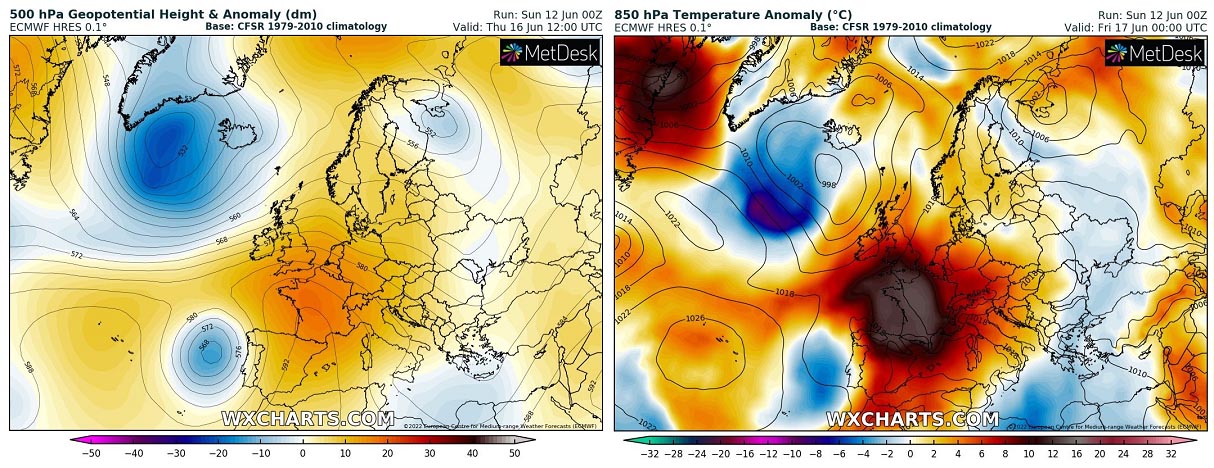
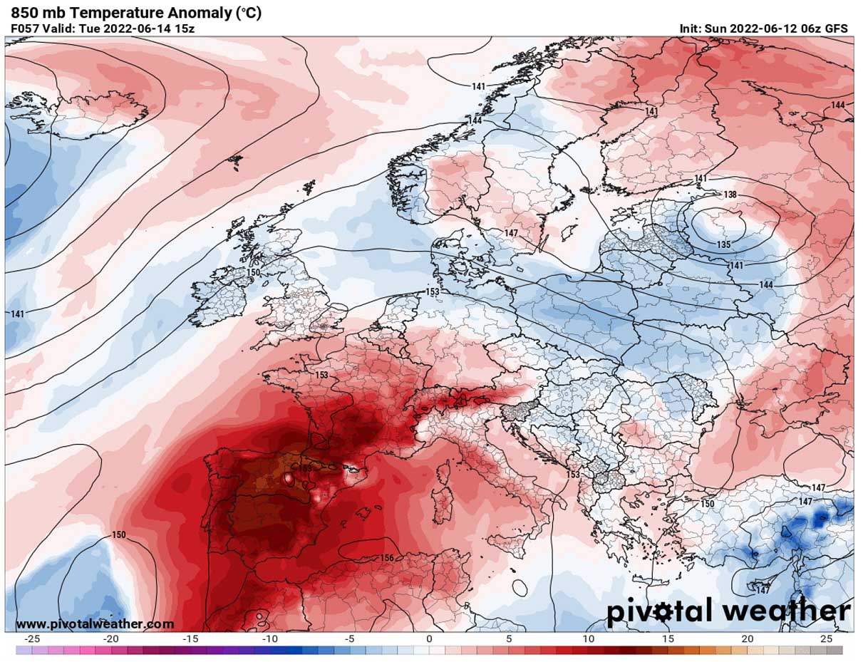
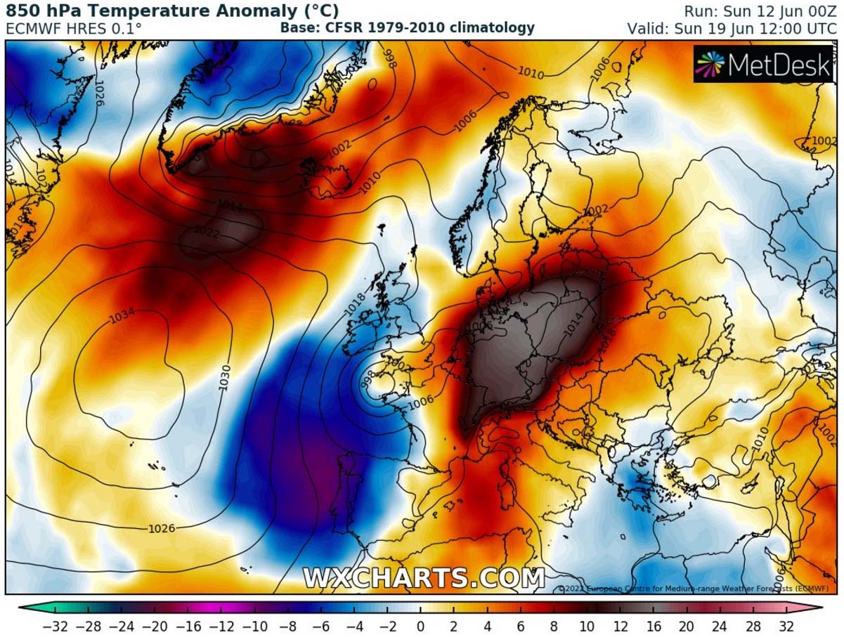
As we can see from the 500 mbar heights and 850 mbar temperature anomaly charts above, an omega blocking pattern dominates the whole of western Europe through mid-week days. Temperatures at about 1250 m above the ground rise to more than 15 °C above normal for mid-June. This means that the exact temperature values at 850 hPa (approx. 1250 m ASL) are forecast to reach 22 to 25 °C in the second part of this week, particularly in southern and southwestern France.
This is really exceptional for this period.
So high temperatures at these levels will not only bring near-record breaking temperatures for the higher elevations but will indeed also translate to the ground levels as air masses are sinking underneath the dome of heat. Temperatures will be higher every day from Monday through Thursday, as the High is forecast to be the strongest from Wednesday into Thursday over France.
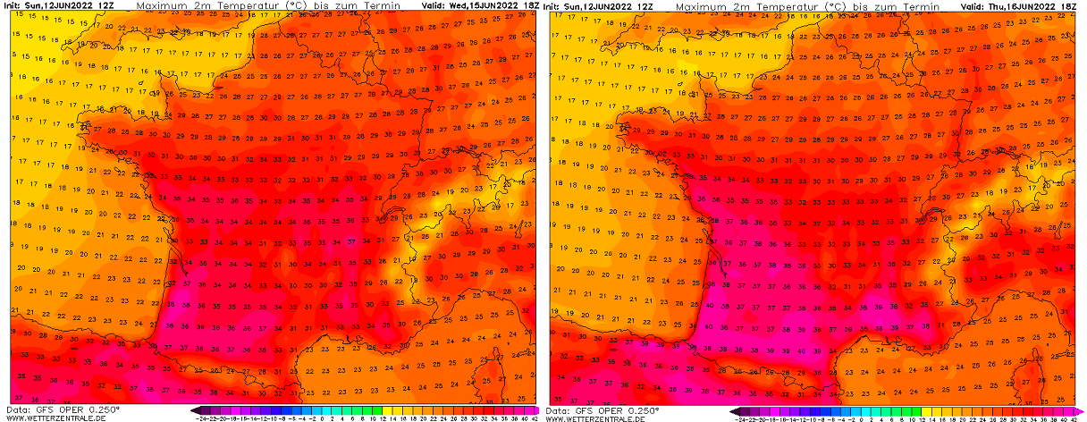
Temperatures will be the highest in southern and southwestern lowlands, with extreme high, possibly record-challenging temperatures for the month of June. The scorching heat is literally warranted by all-weather models across the southern half of France. Likely being the most intense from Wednesday through Saturday. The chart above reveals peak temperatures forecast for Wednesday and Thursday.
Nonetheless, this heatwave will likely bring the earliest 40 °C ever recorded in mainland France, as temperatures this extremely high during the first half of June are exceptional and rare. According to the latest weather model forecast, this threshold will easily be breached in the coming days.
Actually, this is likely to be the earliest heat wave of this intensity ever observed since the start of meteorological records in France.
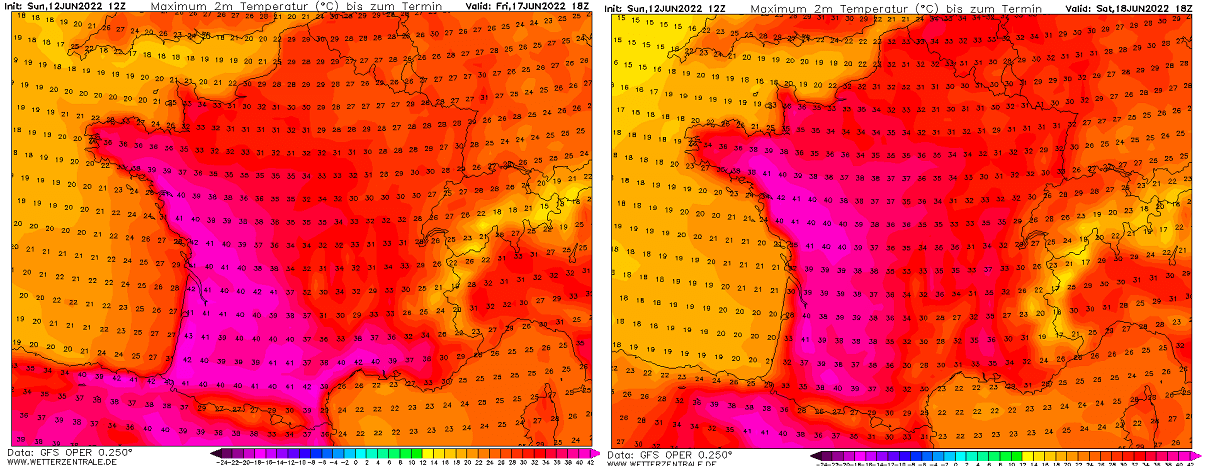
As we can see from the chart above, the heatwave will likely persist into the next weekend. On Friday into Saturday, temperatures are expected to be the highest across western and also northwestern France. Thanks to the upper High gradually expanding towards western Germany and Benelux.
The national highest temperature record for France in June is an astonishing 46 °C in Vérargues (34) on June 28th, 2019. This heatwave will likely not challenge this record, but low to locally mid-40s are easy to be expected on some of the days. Especially across the south, southwest, and also western France through late this week.
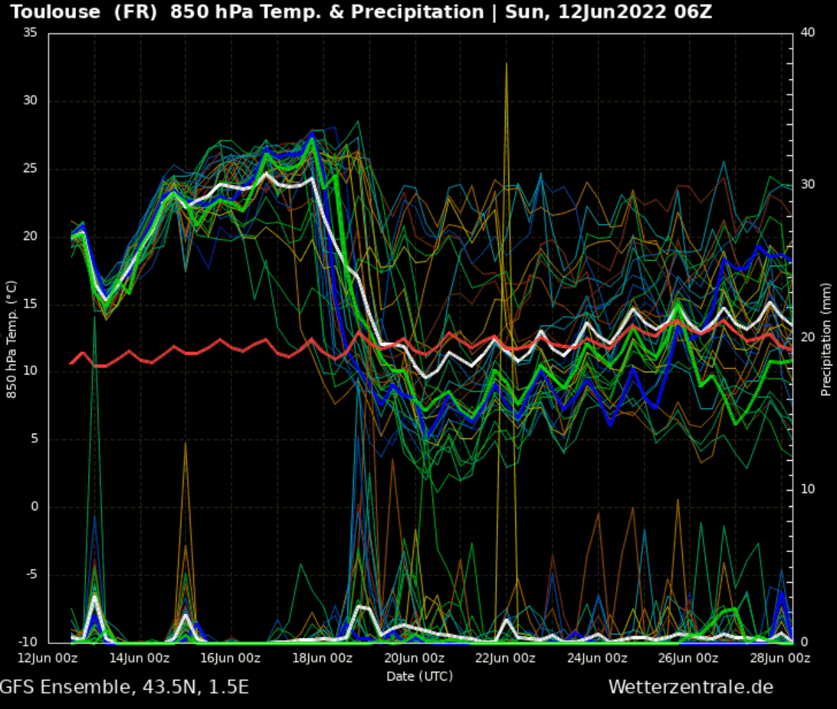
The above Meteogram forecast chart for Toulouse, France surely hints at how intense the heatwave will be this week. While the long-term temperature at the 850 mbar pressure level is around 11-12 °C, the forecast calls for 24-25 °C at this level in southern France. That’s 12-13 °C above normal, very high for mid-June to say at least.
The upcoming period of very hot and also dry air mass will undoubtedly worsen the ongoing drought conditions in France, Spain, and Portugal. The drought conditions are getting worse and worse this month, followed by extremely dry and unusually hot May.
HOW LONG WILL THE HEATWAVE LAST, AND COULD SEVERE WEATHER FOLLOW AFTERWARDS?
The heatwave is likely to begin vanishing late next weekend from north to south as the intrusion of the upper wave from the North Atlantic could lead to the lowering of geopotential heights from western Europe into the Bay of Biscay and towards the Iberian peninsula. Although the period is still quite far in advance, some hints on the general weather pattern change are seen in the forecast models.
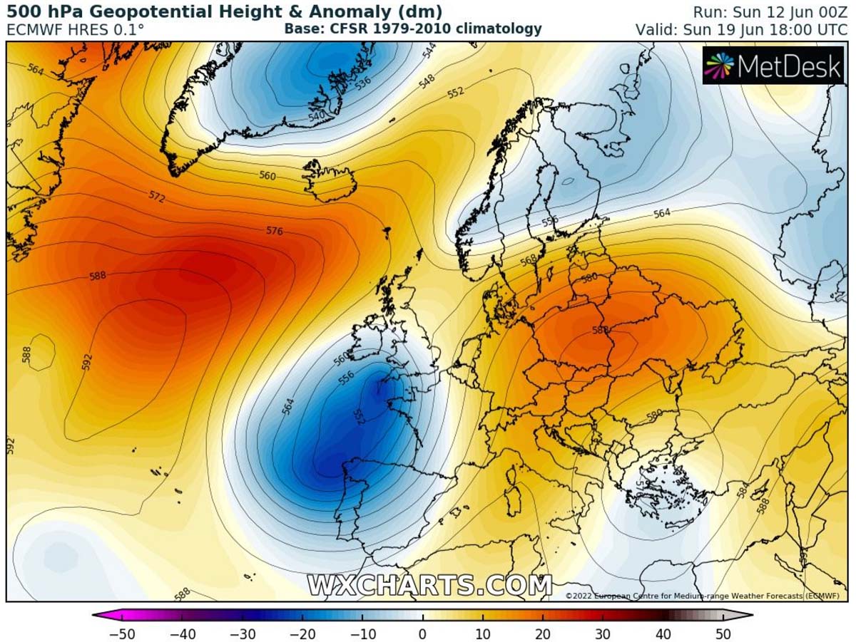
The chart above by the ECMWF forecast model is indicating the development of a large upper wave/low across western and southwestern Europe, causing the upper High to move farther east towards central and eastern Europe. This would indeed increase temperatures over Italy, around the Alps, with Germany, Poland, and Czechia in particular. Being placed under the core of the heat dome.
At the same time, extreme heat would eventually continue and extend across parts of southwestern Europe, from southern France to at least eastern Spain into early next week. Attached below is the temperature anomaly on Sunday, we can see how the heatwave strengthens under the shifted blocking High from the Alps to Germany and the Baltic region.
Besides the higher temperatures over this part of Europe after the weekend, we could see some more progressive weather patterns developing if the trough from the Atlantic digs deeper into the overheated European continent. This could cause another round of more dynamic and stormy weather, but trends have not been too clear with this scenario at this time.
There is a weak cold front coming up around Monday which could spark some severe weather in central Europe. However, especially the European ECMWF model is kind of hinting at the extension of the heat across central parts of Europe next week. That could rise temperatures into the mid to upper 30s again. The GFS, for instance, is leaning more towards the refreshing next week.
Images used in this article were provided by Windy, Pivotalweather, and Wxcharts.
See also: