A rare early Stratospheric Warming event is starting to appear in the forecast for the coming weeks. It shows a weakening and a disruption of the Polar Vortex. This will have a strong impact on the atmospheric circulation, resulting in much colder early Winter 2025/2026 weather over the United States, Canada, and parts of Europe.
An early disruption event in the stratosphere can have a strong effect on the weather patterns as we head into Winter, usually favoring a colder and snowier season.
First, we will quickly look at what the Polar Vortex actually is and why it matters. Then, we will focus on the upcoming stratospheric warming event and how it will help to create a colder early Winter season across the United States, Canada, and potentially also Europe.
NORTHERN POLAR VORTEX
The best way to understand the Polar Vortex is to visualize it in full size. But to keep it simple, the Polar Vortex is just a name that describes the broad winter circulation over the northern (and southern) hemispheres.
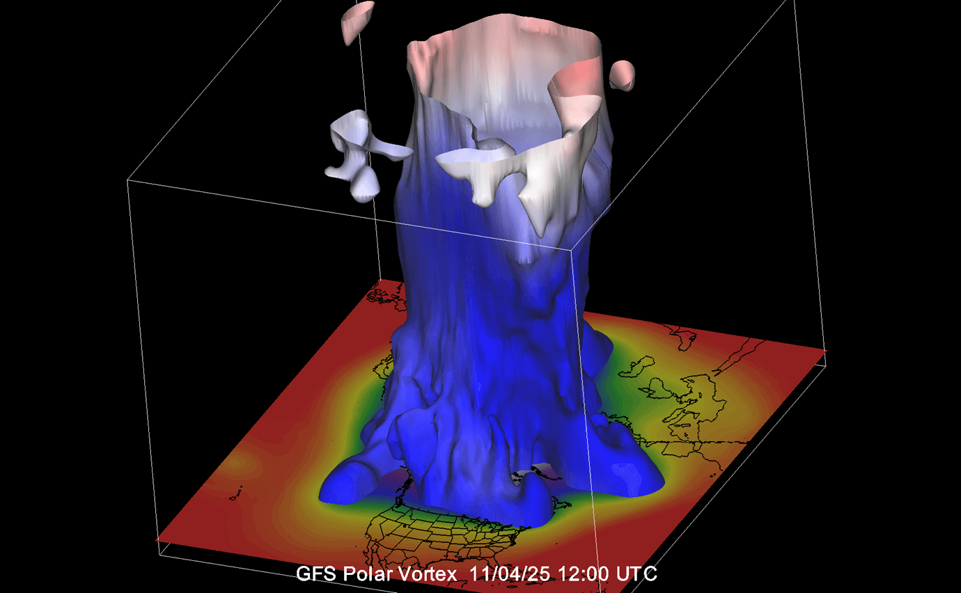
Below, you can see a 3-dimensional image of the Polar Vortex. The vertical axis is greatly enhanced for better visual presentation. It basically shows the actual structure of the Polar Vortex across the atmosphere, connecting to the lower levels and the weather patterns below.
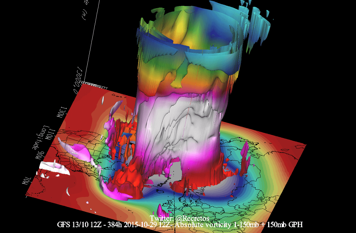
The Polar Vortex extends high up into the atmosphere. The lowest level of the atmosphere is called the troposphere, where all the weather events occur. But above that, we have the stratosphere, a deeper and drier layer, and the home of the ozone layer.
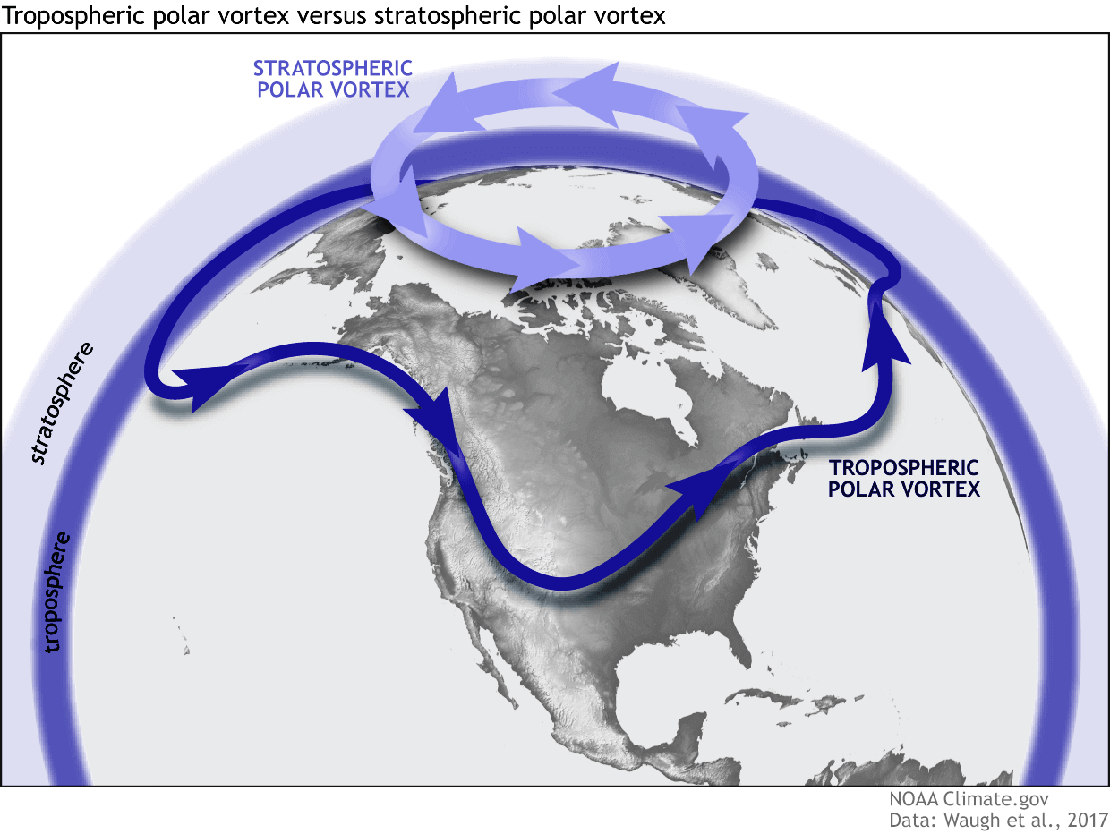
For this reason, we separate the entire Polar Vortex into an upper (stratospheric) and a lower (tropospheric) part. They both play their role differently, so we monitor them separately. But both parts together form the winter circulation across the Northern Hemisphere and the resulting weather patterns.
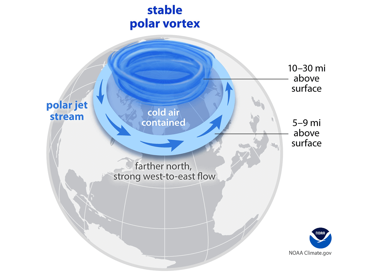
There are several reasons why we care about the Polar Vortex, its strength, and its shape/size. To keep it simple, you can imagine the Polar Vortex as a “wall” spinning over and around the polar regions from the surface to the stratosphere, containing the cold polar air inside.
When the Polar Vortex is strong, it usually means strong polar circulation and jet stream. This basically locks the colder air into the polar regions, preventing its escape, and creating milder conditions for most of the United States, Europe, and other mid-latitudes.
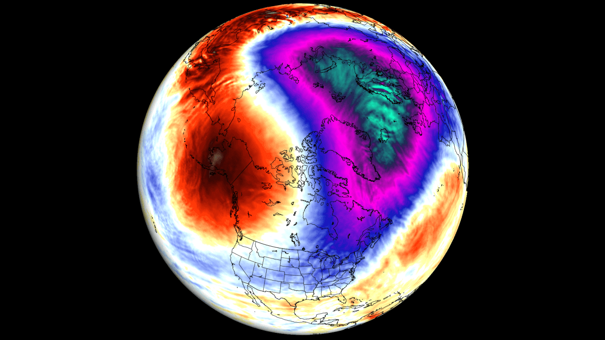
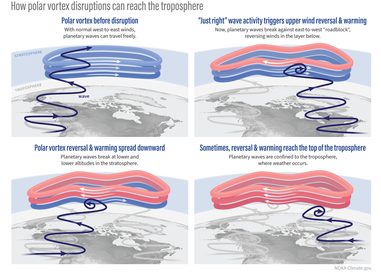
But when the Polar Vortex slows down or gets disrupted, it has a much harder time containing the cold air, which can now more freely escape from the polar regions into the United States or other mid-latitude regions. Below is an example of how a disrupted Polar Vortex helps to release the cold polar air into the United States and Europe at the same time. Both images are by NOAA-Climate.
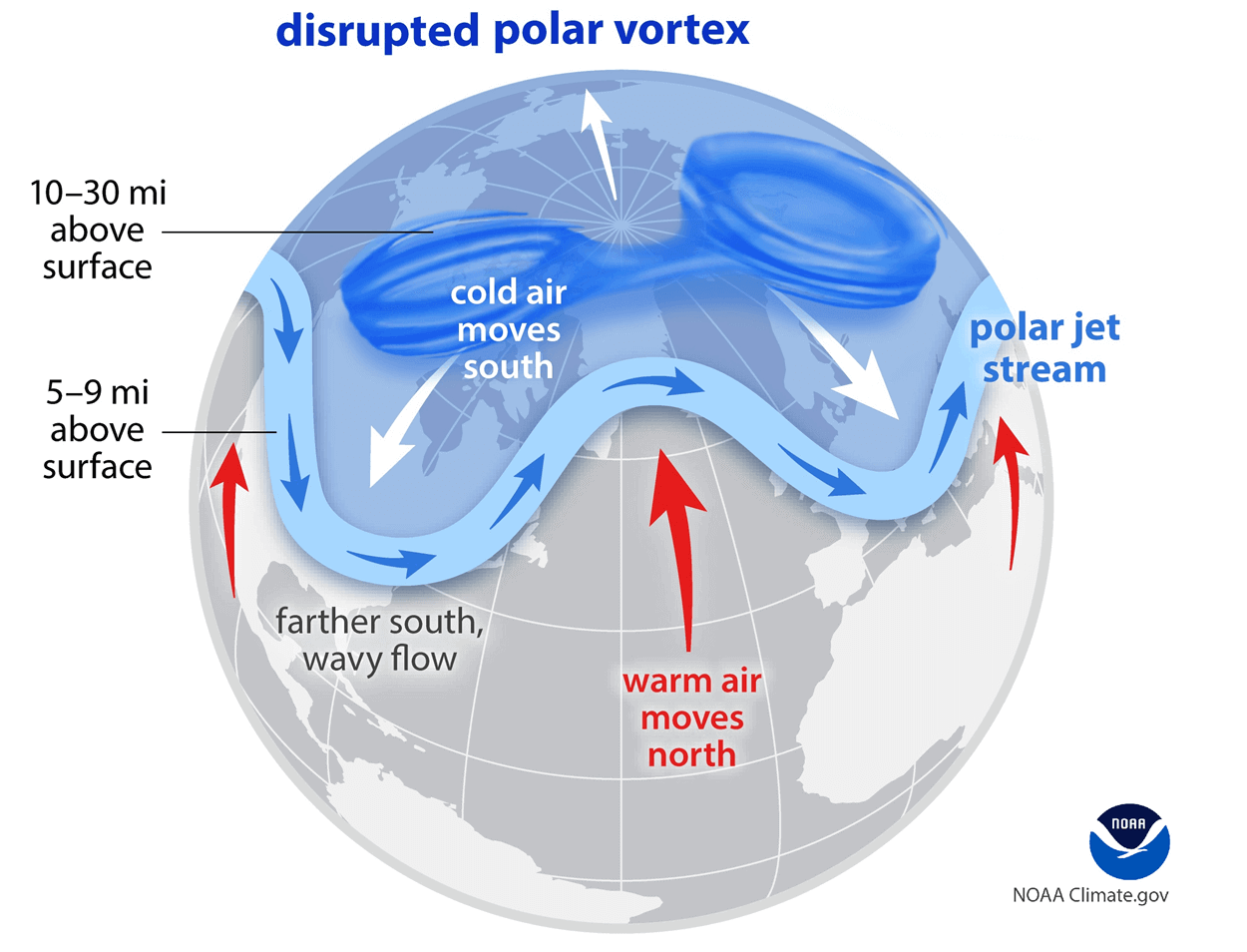
So, if you are a fan of a warmer/mild Winter across the United States or Europe, you will prefer a strong Polar Vortex. But if you like proper Winter weather with cold and snow, a weak/disrupted Polar Vortex is exactly what you want to see.
To put the Polar Vortex into perspective, we produced a high-resolution video below, which shows the Polar Vortex in 3D, giving you a better idea of what it actually looks like. Video shows the latest Polar Vortex forecast and the start of a disruption in the 2025/2026 season.
The main takeaway from the video should be that the Polar Vortex is one large circulation, connected through many layers of the atmosphere.
Now that we know what the Polar Vortex is, we will look at the latest analysis and the weakening prediction, and how it will help to bring a colder start to the 2025/2026 Winter season.
CALM BEFORE THE STORM
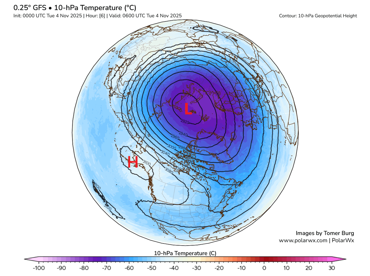
The Polar Vortex is currently normal in size and running at near-normal power. The image below shows geopotential height and temperature analysis in the mid-stratosphere at the 10mb level (30km/18.5miles height). The stratospheric Polar Vortex looks like a large “cyclone” with a cold core near its low-pressure center. Image by PolarWX
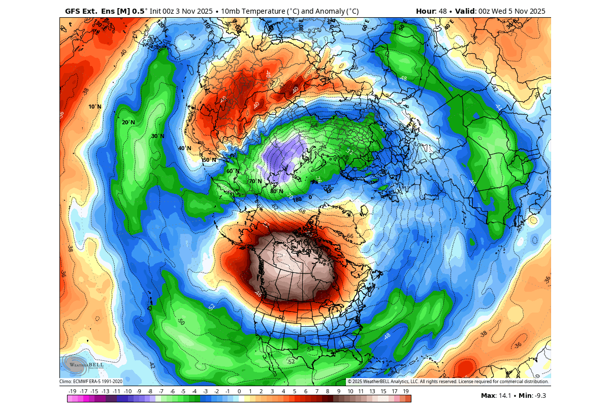
In the image below, you can see the temperature anomaly at the same level in the stratosphere, which shows that the main core of the Polar Vortex is slightly colder than normal. But notice an area of above-normal temperatures over Canada, driven by a local high-pressure area development.
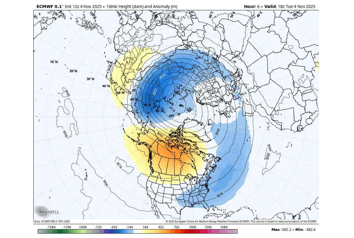
You can see this better in the pressure anomaly image below for the same level. The Polar Vortex is running with lower pressure than usual around its core. But you can see a small high-pressure anomaly over Canada, starting to slightly deform the outer vortex area.
If we look at the 3D analysis of the whole Polar Vortex, we can fully see its current compact structure. It has a somewhat circular shape, and you can also see how it connects to the lower levels, extending its “cold arms”, which are actually areas of low pressure. You can see a small “dent” in the middle levels caused by the area of higher pressure seen above.
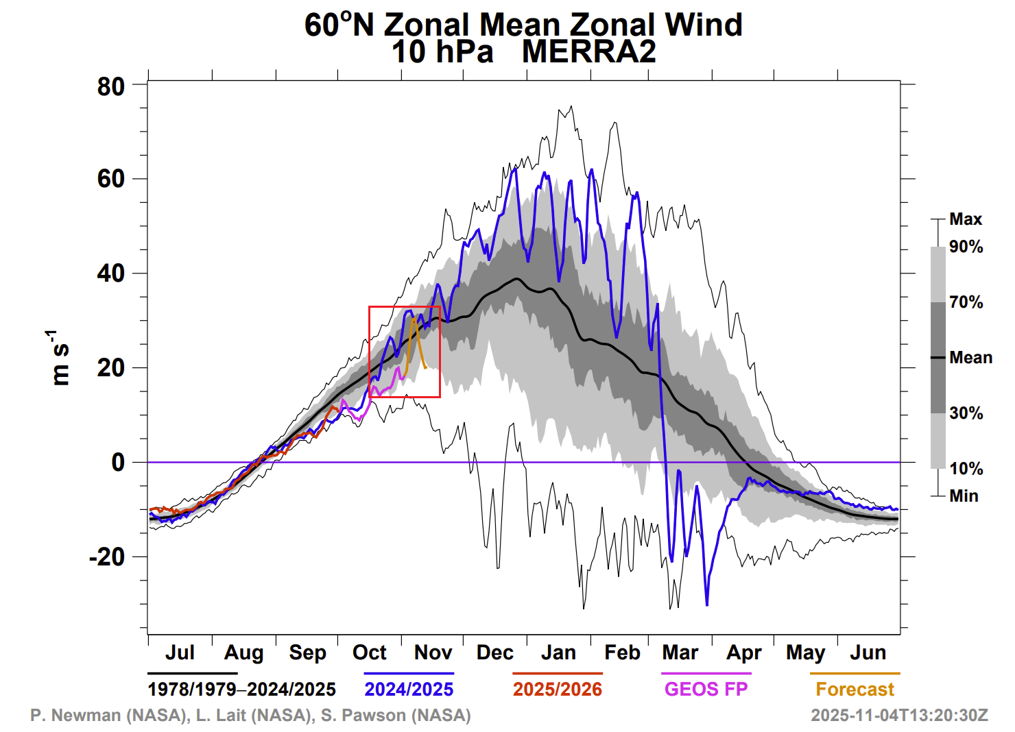
But how do we measure the strength of the stratospheric Polar Vortex? The simple answer is the winds. The more organized the stratospheric Polar Vortex is, the stronger the winds around its core, which usually translates to a stronger influence on the surface.
Below is the latest analysis and forecast of the stratospheric winds around the Polar Vortex from NASA. The latest month is marked, and you can see the Polar Vortex is running slightly weaker than normal. A brief peak in power is forecast, with a rapid reversal into a slowdown.
But what can cause such a rapid deceleration of the Polar Vortex? To slow down such a strong and large circulation takes a lot of energy. There is one event called Sudden Stratospheric Warming (SSW), which is as strong as it sounds and can greatly impact the whole Polar Vortex and change its weather impact.
Most SSW events occur in mid-to-late winter. But this year, the forecast shows a rare early stratospheric warming event, just in time to impact the beginning of the new winter season.
2025/2026 EARLY STRATOSPHERIC WARMING EVENT
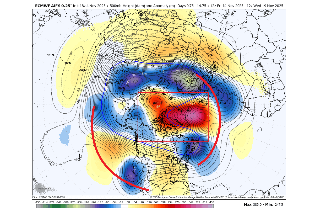
The image below shows the stratospheric extended range wind forecast for the coming weeks. You can see an unusual early weakening (slowdown) of the Stratospheric Polar vortex in the next 4 weeks, bringing Polar Vortex strength to near record lows for this time of year. And for December, its forecast to remain weaker than normal (red box).
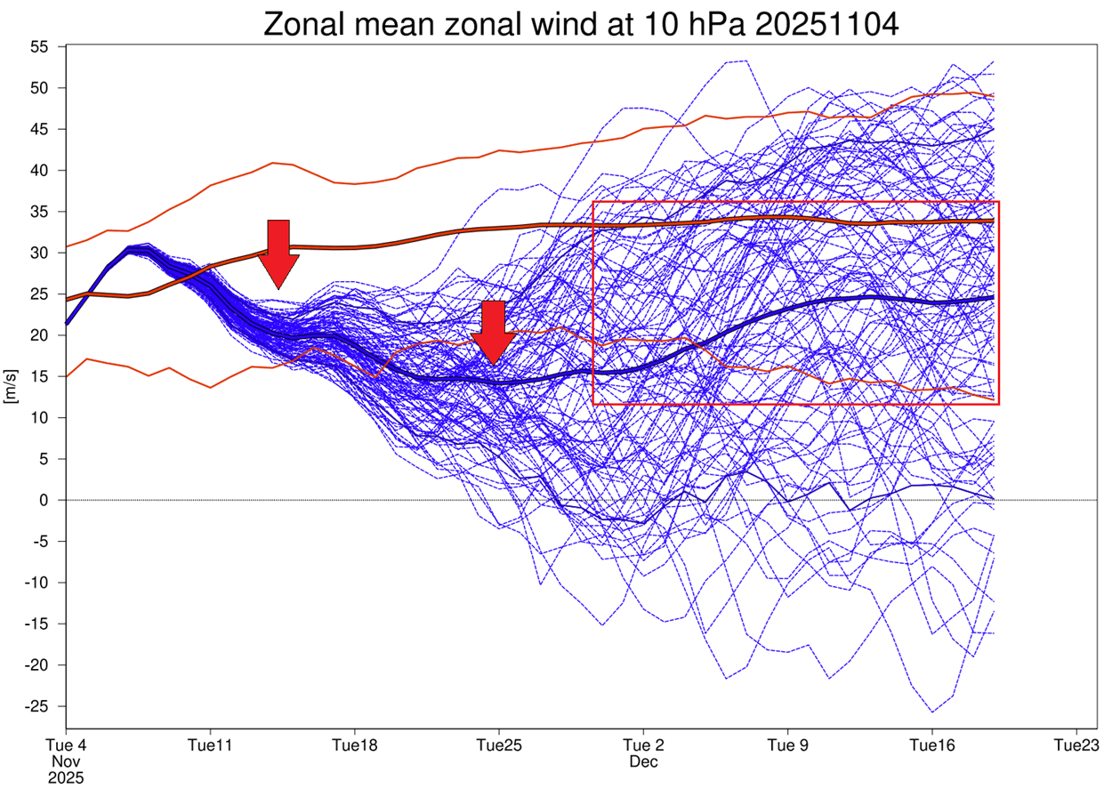
This signals a disruption of the stratospheric Polar Vortex due to a stratospheric warming event. These effects usually transfer down to the lower levels, with some delay, heavily altering the weather patterns.
But how does something so large and strong as the Polar Vortex suddenly start to lose power? Below is a simple schematic of how a Polar Vortex starts to weaken. The main energy comes from the lower levels first, with atmospheric waves bringing disruptive energy into the stratosphere.
This wave energy starts to disrupt the Polar Vortex by creating areas of higher temperature and pressure in the stratosphere, eventually creating a full-blown stratospheric warming event if persistent enough. The disruption of the Polar Vortex then allows for the cold air to more freely escape the polar regions, and cover the United States and Europe in Winter.
As said, it all begins with very strong pressure waves and anomalies in the lower levels (5km/3miles). You can see this below on the forecast for mid-month. Two strong pressure waves are forecast, along with a strong high-pressure system blocking over Greenland, creating a very energetic lower-level pressure pattern.
Such strong pressure waves can send a lot of energy upwards into the stratosphere. This manifests as a rise in pressure and temperature around the Polar Vortex, which is why we see a slowdown in the forecast towards December.
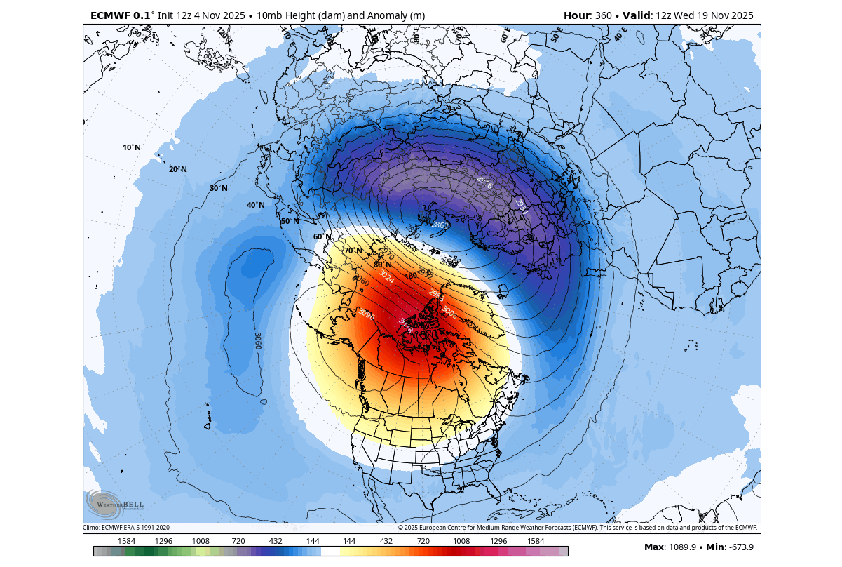
Below is the mid-stratosphere pressure anomaly forecast for the same period. In this image, you can better see the growing high-pressure anomaly in the mid-stratosphere at the 10mb level (30km/18.5miles height), squeezing the Polar Vortex, disrupting and slowing it down in the process.
Such a stratospheric warming event is important at this time of year. Any large-scale pressure changes in the stratosphere, especially of this magnitude, can mean substantial weather impacts down the line as we go into Winter.
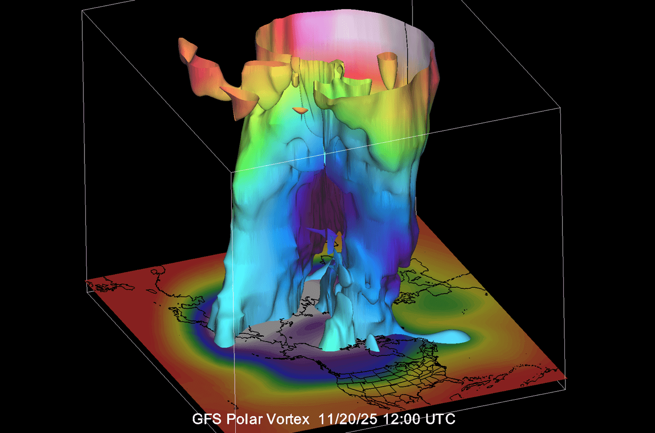
Below is also a 3D structure forecast of the Polar Vortex for around mid-month. You can clearly see the split structure in the lower levels of the stratosphere, which is where the high-pressure anomaly is making a large “dent” into the Polar Vortex. This is what you usually expect to see when a forecast calls for a warming/disruption event.
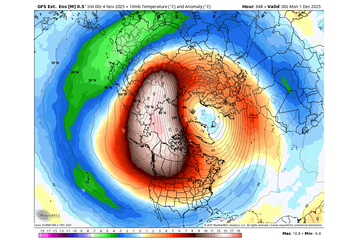
We can look at the extended ensemble forecast for early December trends. The forecast below currently shows an ongoing stratospheric warming event, with a strong warming wave further weakening the Polar Vortex, right on the doorstep of the Winter season.
So, what will be the impacts of this stratospheric warming event and the Polar Vortex weakening on the Winter 2025/2026? For this, we will now move into the lower levels, using the latest forecast data.
STRATOSPHERIC WARMING AND EARLY WINTER WEATHER
Sudden Stratospheric Warming (SSW) basically means a strong temperature and pressure rise in the Stratosphere. That causes a major disturbance in the circulation and, as a result, can full collapse the Polar Vortex. But how does it actually change the weather?
Below is a typical example of how a stratospheric warming event works. The image below shows pressure anomalies across the atmosphere over the whole period of an SSW event. You can see how the main event in the stratosphere affects the surface layers downwards over a certain time period.
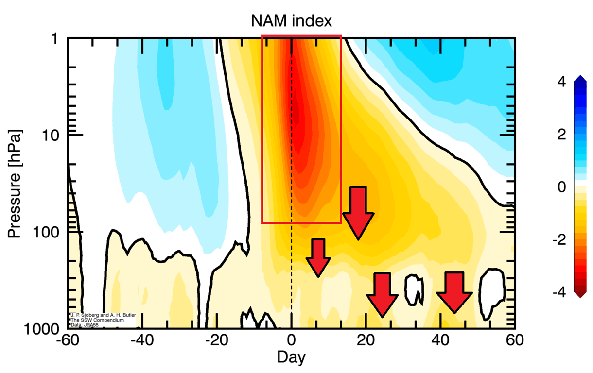
A stratospheric warming event usually means that high-pressure anomalies from the stratosphere can make their way to the surface. This disrupts the jet stream, helping to release cold air from the polar regions down into the United States, southern Canada, and Europe.
Based on this information, we can look at the lower-level pressure anomaly forecast for early December (start of meteorological Winter) for potential impacts. You can see how the forecast shows the expected blocked North Pole, with low-pressure areas and cold air being released into the mid-latitudes.
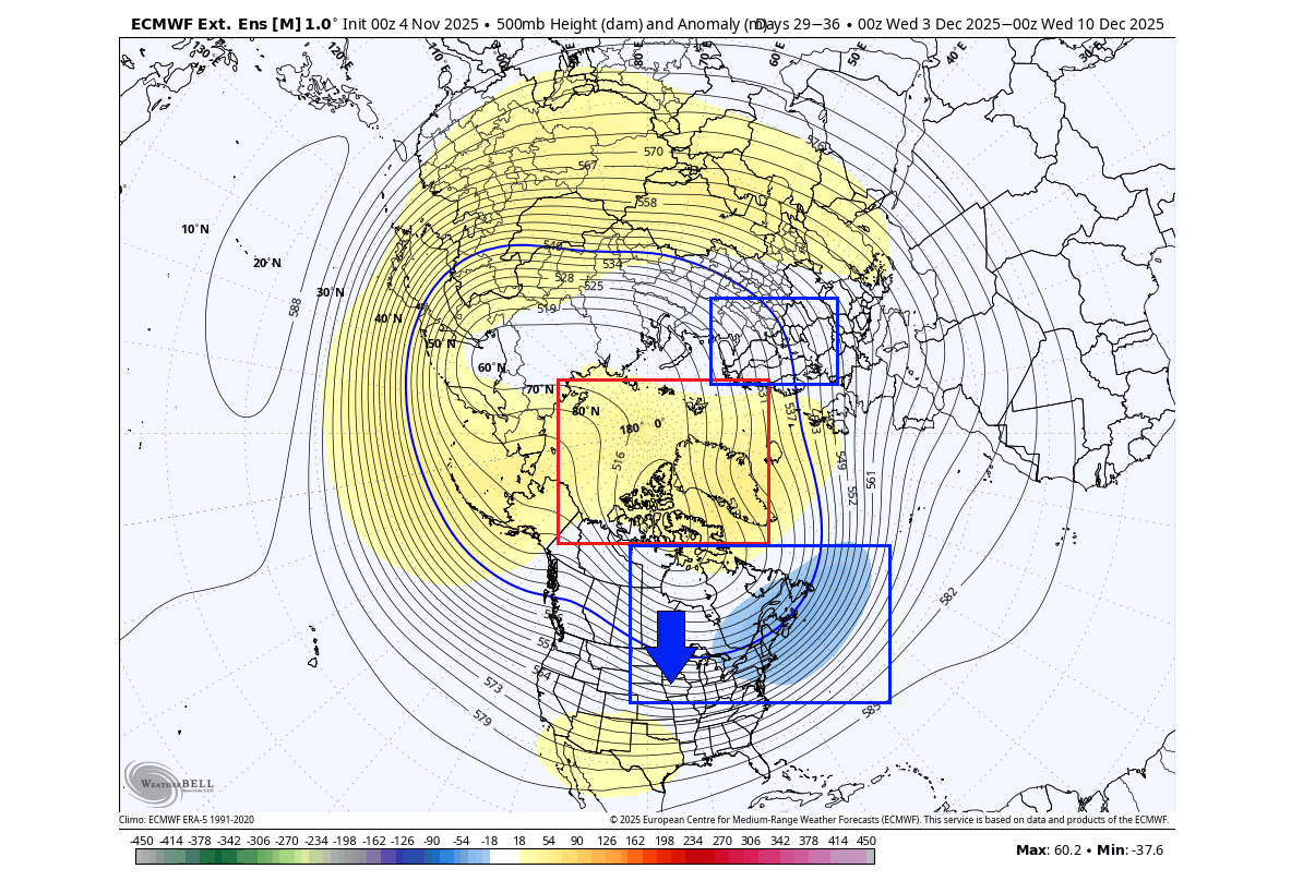
This is exactly what we would expect to see following a disruption and a split of the lower Polar Vortex. We can see this as a strong indication of a cold (snowy) start to Winter across the United States, southern Canada, and parts of Europe.
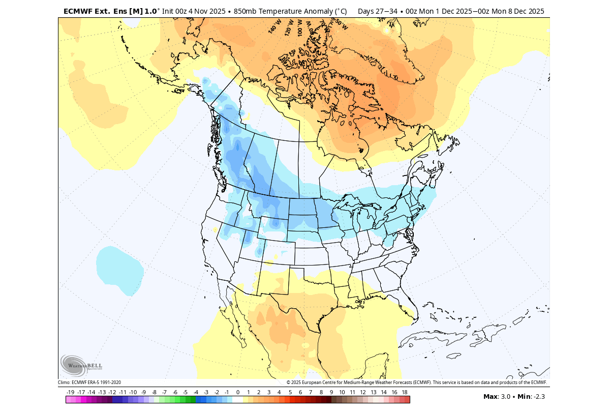
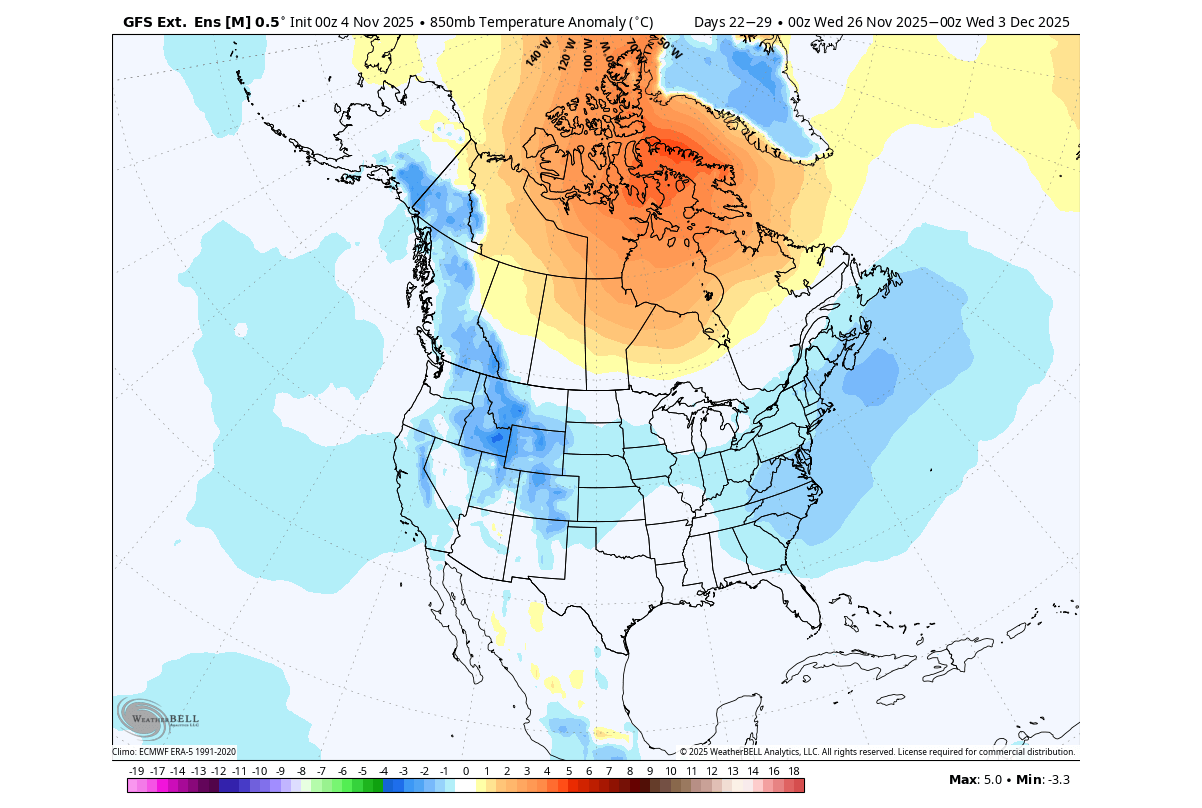
The temperature forecast for early December indicates a potentially strong cold polar air outbreak across the northern, central, and eastern United States. Despite being an extended-range forecast, this is what we usually expect to get from Polar Vortex disruption events in the stratosphere.
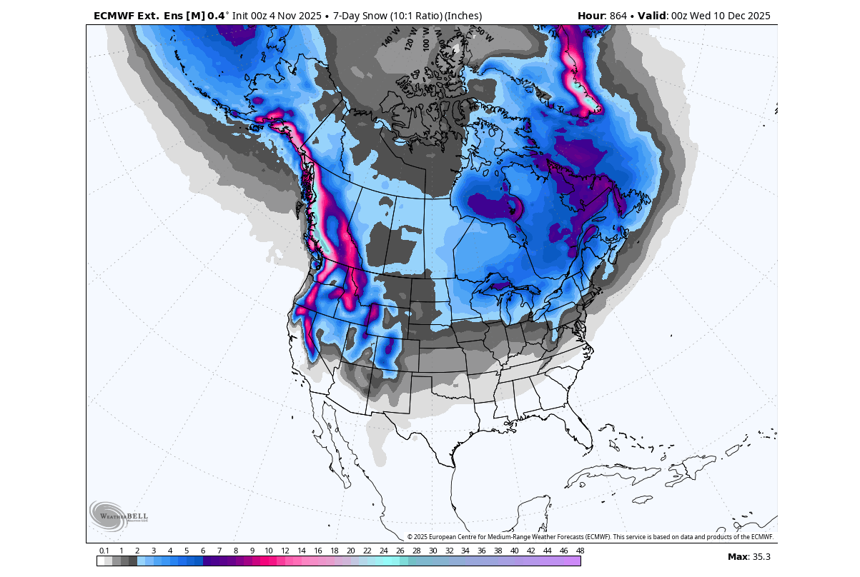
Looking at the snowfall forecast for the first half of December, you can see a good spread of total snowfall from southern Canada into northern, western, and northeastern United States, with possible spread also over the Plains and the east. This is, of course, an ensemble average, so what matters is not the actual numbers but the overall coverage.
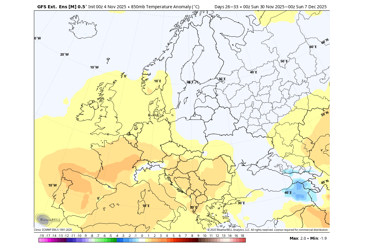
Over Europe, we currently see support for a cold air anomaly over the northern and central parts, and also over the UK. This is due to the low-pressure area sitting over the north/northeast, enabling a northerly flow into the continent.
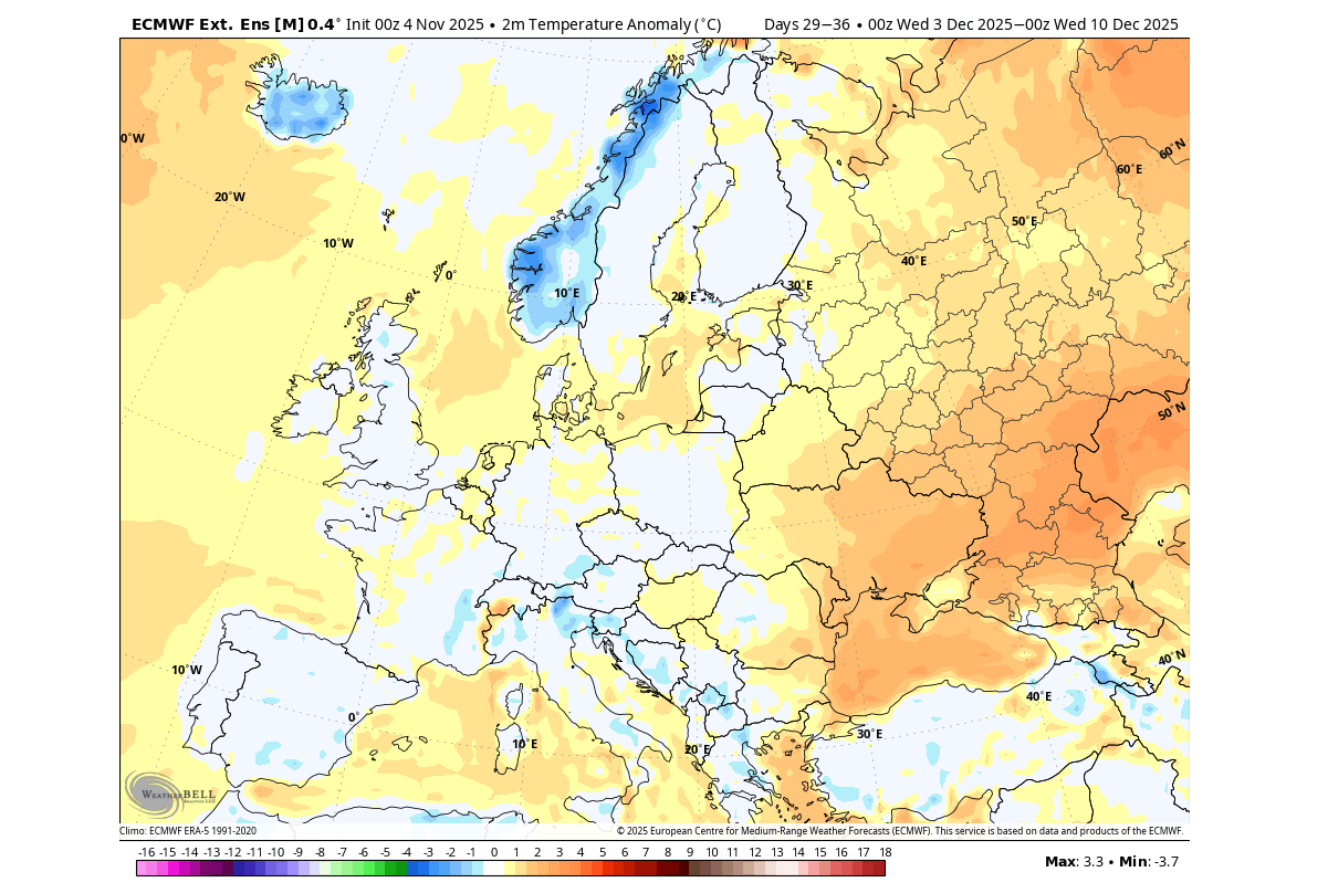
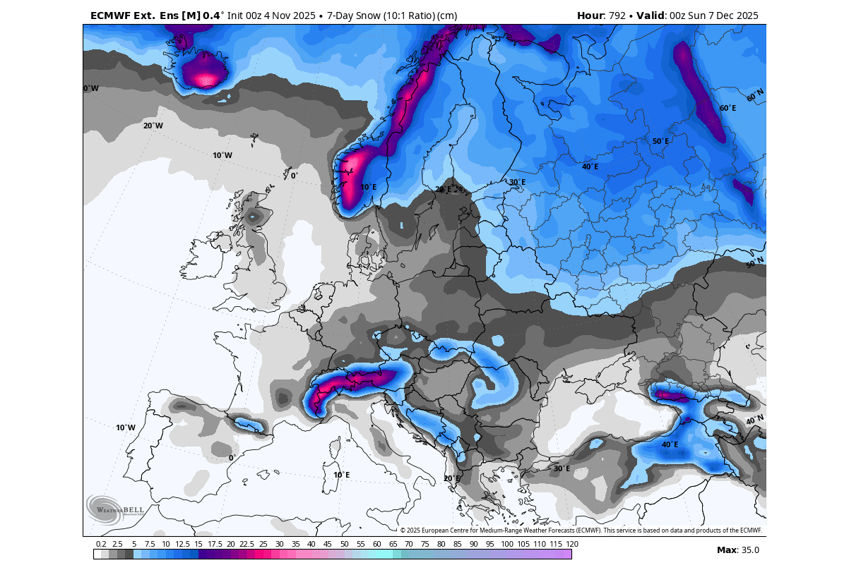
Snowfall forecast for this period shows snowfall spread over central and northern parts, and over parts of the UK. And of course, here we also have to add that this is an extended ensemble mean, so the total forecast numbers are usually underestimated, especially at this far range, where coverage is what matters.
Below is the temperature anomaly forecast for the same early December period, but from another model (GEFS). We tend to look at different forecasts because if more models agree on a similar pattern, it usually means that it is a more likely scenario. You can see the same cold air “spill” scenario across the United States and southern Canada.
This model shows a weaker cold signal for Europe, mainly hinting at northern and northeastern parts, while the rest show a warmer anomaly. The reason is the position of the low-pressure area over this sector, which is further to the northeast than in the first model.
At this point, what matters is that we have the stratospheric warming response signal, so that there is a visible impact on the early Winter weather patterns. Typically, North America benefits more often than other regions of the Northern Hemisphere, but current signs do leave an open door for cold also over Europe.
The latest long-range forecast from the Canadian CanSIPS model was also just released. It shows a cold air anomaly spreading in the same pattern from southern Canada into the northern, central, and eastern United States. This is a monthly average, so it’s even more impressive to show such a cold spread.
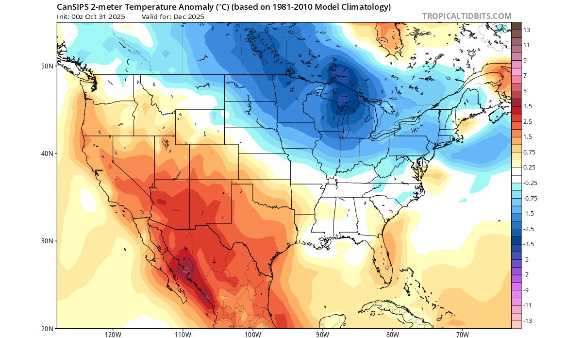
Overall, we are witnessing a developing trend for a properly cold weather period, at least in the first half of December, due to the disrupted Polar Vortex in the stratosphere.
We will keep you updated on the global weather pattern development, so don’t forget to bookmark our page. Also, if you have seen this article in the Google App (Discover) feed, click the like button (♥) there to see more of our forecasts and our latest articles on weather and nature in general.
The main forecast images in this article are from WeatherBell, using a commercial forecaster license.
Don’t miss: